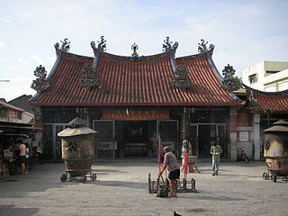
Goddess of Mercy temple
Jalan Masjid Kapitan Keling, George Town, 10200 George Town, Pulau Pinang, Malaysia

Kong Hock Keong Temple also Kuan Ying Teng Temple (Goddess of Mercy temple) is a Taoist and Buddhist temple in George town, Penang built in 1800 by early Chinese settlers of the Hokkien and Cantonese communities. It is located on Jalan Kapitan Keling in north-west Malaysia. It is dedicated to the worship of Guanyin.
Constructed in accordance to Feng Shui principles, the Kong Hock Keong Temple has three wells – one on the right side of the main shrine, another outside the temple and the third hidden under the main altar of the Goddess of Mercy. The water from the wells is believed to be able to cure illnesses.
The Kong Hock Keong Temple has come through threats, unscathed, time and again. Not only did it survive a bomb dropped by the Japanese invasion of the Second World War, but also other threats through the years, including the fire of 1846, the terrorist granade attack on the Penang power sub-stations at Pitt Lane and the Chinese Town Hall next door to the temple,[5] and the middle-of-the-night blaze that destroyed the nearby stalls selling oil and joss paper.
Source : Wikipedia
https://www.youtube.com/watch?v=8-Zvg5JXxK0
https://www.youtube.com/watch?v=oihuxpo0Sz4
Reviews
Visiting hours : Early morning to Late evening
Getting there : The Goddess of Mercy temple can be easily found within the center of George Town. Usually travelers are staying somewhere around Chulia Street; it is very near this popular backpackers area.From Chulia Street, head right just past the Indian temple into Jalan Masjid Kapitan Keling. From here it is a 5 minute walk to the temple entrance.


_-_base_du_mandapa.jpg?resize=403%2C538&ssl=1)