https://www.youtube.com/watch?v=lsjbBZX56VI

Mount Hua Shan
Mount Hua is a mountain located near the city of Huayin in Shaanxi province, about 120 kilometres (75 mi) east of Xi’an. It is the western mountain of the Five Great Mountains of China, and has a long history of religious significance. Originally classified as having three peaks, in modern times the mountain is classified as five main peaks, of which the highest is the South Peak at 2,154.9 metres (7,070 ft)
Villarica Volcano
Villarrica is one of Chile’s most active volcanoes, rising above the lake and town of the same name, 750 km (470 mi) south of Santiago. It is also known as Rucapillán, a Mapuche word meaning “Pillan’s house”. It is the westernmost of three large stratovolcanoes that trend NW-SW obliquely perpendicular to the Andean chain along the Mocha-Villarrica Fault Zone, along with Quetrupillán and the Chilean portion of Lanín, are protected within Villarrica National Park. Guided ascents are popular during summer months.
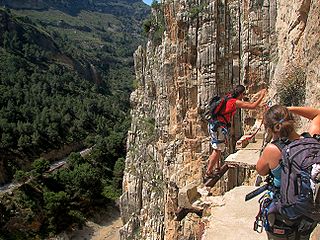
El Caminito del Rey
El Caminito del Rey is a walkway, pinned along the steep walls of a narrow gorge in El Chorro, near Ardales in the province of Málaga, Spain. The name is often shortened to Camino del Rey (English: King’s pathway). The walkway had fallen into disrepair and was partially closed for over a decade. After four years of extensive repairs and renovations, the walkway re-opened in 2015. It has been known in the past as the “world’s most dangerous walkway” following five deaths in 1999 and 2000.
Yosemite National Park
Yosemite National Park is a national park spanning portions of Tuolumne, Mariposa and Madera counties in Northern California. The park, which is managed by the National Park Service, covers an area of 747,956 acres (1,168.681 sq mi; 302,687 ha; 3,026.87 km2) and reaches across the western slopes of the Sierra Nevada mountain range. On average, about 4 million people visit Yosemite each year, and most spend the majority of their time in the seven square miles (18 km2) of Yosemite Valley. The park set a visitation record in 2016, surpassing 5 million visitors for the first time in its history.
Poison Garden
The Alnwick Garden is a complex of formal gardens adjacent to Alnwick Castle in the town of Alnwick, Northumberland, England. A garden featuring intoxicating and poisonous plants was added in February 2005. Species of the Poison Garden include Strychnos nux-vomica (source of strychnine), hemlock, Ricinus communis (source of harmless castor oil but also deadly ricin), foxglove, Atropa belladonna, Brugmansia and Laburnum.The mission of the Poison Garden also includes drug education, with featured plantings of cannabis, coca and the opium poppy Papaver somniferum.
Mount Everest
Mount Everest, also known in Nepal as Sagarmāthā and in China as Chomolungma, is Earth’s highest mountain. Its peak is 8,848 metres (29,029 ft) above sea level. Mount Everest is in the Mahalangur Range. The international border between China (Tibet Autonomous Region) and Nepal runs across Everest’s summit point. Its massif includes neighbouring peaks Lhotse, 8,516 m (27,940 ft); Nuptse, 7,855 m (25,771 ft), and Changtse, 7,580 m (24,870 ft).
Praia De Boa Viagem
The Boa Viagem is the most famous urban beach of the city of Recife , the state capital of Pernambuco . Being approximately seven kilometers (7 km) long and located in the Boa Viagem neighborhood (South Zone of the capital of Pernambuco), it is bounded by Praia do Pina (Praia do Sport) on one side and Praia de Piedade on the other.
Most of Boa Viagem beach is protected by a barrier of natural reefs , which gave its name to the city.
Colorado River
The Colorado River (Spanish: Río Colorado, lit. “colored”, with an implication of reddish) is one of the principal rivers of the Southwestern United States and northern Mexico (the other being the Rio Grande). The 1,450-mile-long (2,330 km) Colorado River drains an expansive, arid watershed that encompasses parts of seven U.S. and two Mexican states. Starting in the central Rocky Mountains in the U.S., the river flows generally southwest across the Colorado Plateau and through the Grand Canyon before reaching Lake Mead on the Arizona–Nevada border, where it turns south toward the international border. After entering Mexico, the Colorado approaches the mostly dry Colorado River Delta at the tip of the Gulf of California between Baja California and Sonora.
Source : wikipedia