Sooryakanthi Rd, Nanthancodu, Thiruvananthapuram, Kerala 695033
Phone : +91 471 2473952
Image Credit : tripadvisor.in
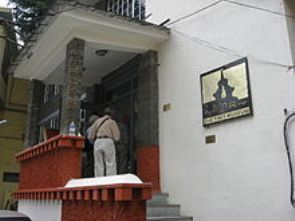
The Sree Chithra Gallery near the Napier Museum was opened in 1935 by the then Maharaja of Travancore, Sree Chithira Thirunal, displays rare collection of paintings by Raja Ravi Varma, Svetlova and Nicholas Roerich; exquisite works from the Mughal, Rajput and Tanjore schools of art. An oriental collection consisting of paintings from China, Japan, Tibet and Bali offers a visual treat and are a tribute to the art and culture of these countries. The collection also includes unique copies of Indian mural paintings from pre-historic times down to the 18th Century.
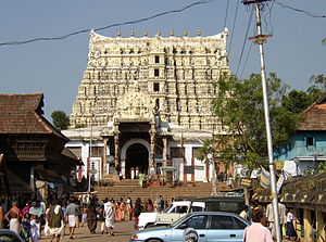
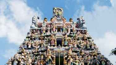
Sree Padmanabhaswamy temple is located in Thiruvanathapuram, Kerala, India. The temple is built in an intricate fusion of the indigenous Kerala style and the Dravidan style of architecture associated with the temples located in the neighboring state of Tamil Nadu, featuring high walls, and a 16th-century Gopuram While theMoolasthanam of the temple is the Ananthapuram Temple in Kasargod, architecturally to some extent, the temple is a replica of the Adikesava Perumal temple located in Kanyakumari District. It is the richestHindu temple in the world. In terms of assets gold and precious stones, it is by far the wealthiest institution and place of worship of any kind, in the recorded history of the world.
The principal deity Vishnu is enshrined in the “Anantha Shayanam” posture, the eternal yogic sleep on the serpent Adisheshan. Sree Padmanabhaswamy is the tutelary deity of the royal family of Travancore. The titular Maharaja of Travancore Moolam Thirunal Rama Varma is the trustee of the temple as Sree Padmanabhadasa, the slave of Lord Padmanabha. In line with the Temple Entry Proclamation, only those who profess the Hindu faith are permitted entry to the temple and devotees have to strictly follow the dress code.
Padmanabhaswamy Temple is the wealthiest place of worship in the world. It is conservatively estimated that the value of the monumental items ( from the 5 vaults among the six ) is close to 1.2 lakh crore or 1.2 trillion (US$18 billion). If the antique and cultural value were taken into account these assets could be worth ten times the current market price. The gold and precious stones contained in Vault B, which is by far the largest and the only vault (of the reported six) that is unopened so far, since the discovery of the treasure, were worth 12,000 crores. Considering the subsequent inflation of the rupee, and the increase in the prices of gold and precious metals and precious stones since in general, the treasure in the unopened vault B alone, would be worth at least 50 trillion (US$1 trillion) in present-day terms, without the cultural value being factored in.
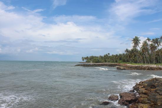
The Parasurama Temple at Thiruvallam is located 7 km from Thiruvananthapuram in Kerala. It is a 2000-year-old temple on the banks of the River Karamana and is the only one in Kerala dedicated to Sree Parasurama, the mythological creator of the State. This temple is a venue for ancestor worship. As part of the bali ritual, devotees make offerings to the souls of the departed, after taking a dip in the holy water.
Source : keralatourism.org
This temple is situated at Thiruvallam in Thiruvananthapuram City on Kazhakkuttam-Kovalam by-pass road. The temple is located at the ‘Triveni Sangama’ of rivers Karamana, Killi and Parvathiputhanar. The main speciality of this temple is that, it is a Trimurthy temple were Lord Shiva, Lord Vishnu and Lord Brahama have separate shrines.
Kottakkakam Road, Thrippunithura, Ernakulam, Kerala 682301
Phone: 0484 277 6655
Image Credit : commons.wikimedia.org
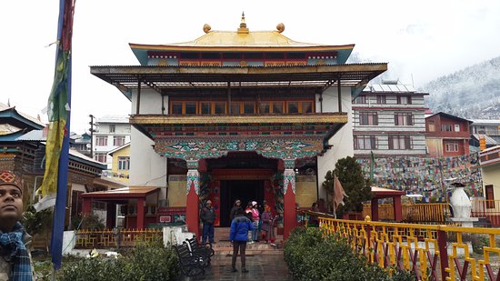
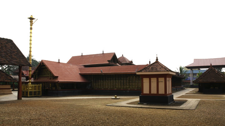
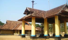
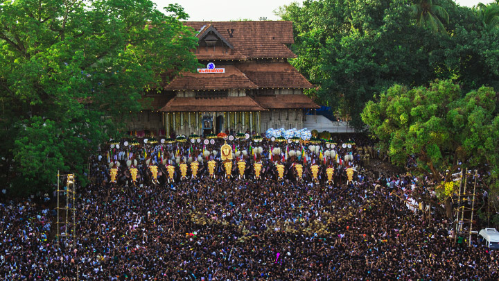
Sree Poornathrayesa temple is situated in Tripunithura, Kochi, the capital of the former Kingdom of Cochin. The temple is considered among the greatest temples in Kerala and was first among 8 royal temples of erstwhile Kochi Kingdom. The deity was also considered as National deity of Cochin and protector guardian of the town of Tripunithura.
The temple is famous for its yearly Utsavams or festivals. The main one is the Vrishchikoltsawam,[1] which is conducted every year in the month of Vrishchikam (November–December), kicking off the ‘Ulsava’ Season in Kerala. And this Vrishchikolsavam is the biggest temple festival of Ernakulam District and one of the biggest temple festivals of Kerala also.
The deity in this temple is Lord Vishnu who is in the form of Santhanagopala Murthy. It is well believed that childless couples will be blessed with children on praying Poornathrayesan.
Temple Structure
The temple is designed in accordance of Kerala temple architecture. A major fire occurred in 1920, which destroyed much of the original structure particularly the sanctum sanctorium which was built extensively in wood. This led to redesigning the temple with concrete structure, for the first time in Kerala. Designed by the illustrious architect Late Sri Eachara Warrier, the temple was redesigned with concrete structure, covered cleverly with copper plates, wooden panels and granite tiles to recreate the traditional structure feeling.
The side walls of sanctum sanctorim where heavily decorated with large brass sheets with statutes of gods and goddess, while the roof is covered with copper sheets, while the entrances of sanctum sanctorium were covered with gold sheets.
Architecture
The first floor of the two-storied gopuram consists of a mandapam (Dias), and eight beautifully carved wooden pillars support the Mandapam.
Famous Festivals Vrishchika Ulsavam
This festival usually starts in the November–December time frame every year. The festival lasts for 8 days, with events running 24/7. Events feature traditional folk art forms such as Ottanthullal, Kathakali, Thayambaka, Chenda melam, Kacheri. Stalls are set up in front of and behind the temple selling food and various articles.
Source : wikipedia https://www.youtube.com/watch?v=FBediMEl5DY https://www.youtube.com/watch?v=VZDjzGQ-bQc Timings : 3.45 am -11.am, 4 p.m-8.30 pm Reviews https://goo.gl/cd5qiC
Jalan Tun H S Lee, 50000 Kuala Lumpur, Wilayah Persekutuan Kuala Lumpur, Malaysia
Phone : +603 2078 3467
Sri Mahamariamman TempleThe temple’s main shrine to Sri Maha Mariammman
The Sri Mahamariamman Temple is the oldest Hindu temple in Kaula Lumpur, Malaysia. Founded in 1873, it is situated at edge of Chinatown in Jalan Bandar (formerly High Street). In 1968, a new structure was built, featuring the ornate ‘Raja Gopuram’ tower in the style of South Indian temples.
From its inception, the temple provided an important place of worship for early Indian immigrants and is now an important cultural and national heritage.
Built in the South Indian style, the temple’s most outstanding feature is the impressiven 5-tiered gopuram (tower). It is the tallest structure in the temple. The dramatic 22.9m (75ft) high pyramid-shaped gate tower is decorated with depictions of Hindu gods sculpted by artisans from southern India. The chief sculptor was the late S. T. Muniappa from Tamil Nadu and is credited for creating the 228 idols on the gopuram.
This Temple resembles the form of a human body lying on its back with the head positioned towards the west and the feet towards the east. The temple’s 5-tiered gopuram corresponds to the feet of the body. It is the threshold between the material and spiritual world.
A silver chariot is housed within the premises. This chariot is a prominent feature during the annual Thaipusam festival. It used during this occasion for transporting the statuettes of Lord Muruga and his consorts (Valli and Teivayanni) through the city streets to Batu Caves. It made its debut in 1893 and was built at a cost of RM350,000 using 350 kilograms of silver.
The chariot was made in India and shipped here in 12 parts to be assembled. It is 6.5 metres tall and has 240 bells and a pair of horses on it. Before the silver chariot, a wooden one was used which was made 1930 by Indian craftsmen at a cost of RM50,000.
Getting there : The temple is located within Chinatown, near Petaling Street. If you are coming by metro, just exit at the Pasar Seni LRT station. From there you have to walk about 50 meters along Jalan Sultan, and then turn left into Jalan Tun H. S. Lee. You will see Sri Mahamariamman on your left side after 50 meters. Jalan Tun H. S. Lee runs parallel to Petaling Street.
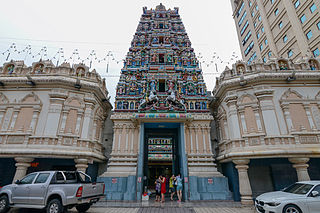
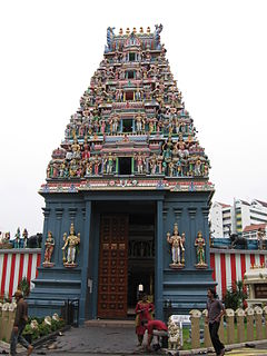
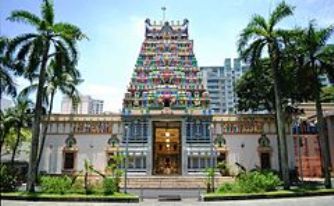
The Sri Mariamman Temple is Singapore’s oldest Hindu temple. It is an agamic temple, built in the Dravidian style. Located at 244South Bridge Road, in the downtown Chinatown district, the temple serves the majority Hindu Singaporeans, Tamilians, in the city-state. Due to its architectural and historical significance, the temple has been gazetted a National Monument and is a major tourist attraction. Sri Mariamman Temple is managed by the Hindu Endowments Board, a statutory board under the Ministry of Community Development, youth and Sports .
The Sri Mariamman Temple was founded in 1827 by Naraina Pillai, eight years after the East India Company established a trading settlement in Singapore. Pillai was a government clerk from Penang who arrived in Singapore with Sir Stamford Raffles on his second visit to the island in May 1819. Pillai went on to set up the island’s first construction company, and also entered the textile trade. He rapidly established himself in business and was identified as a leader of the Indian community.
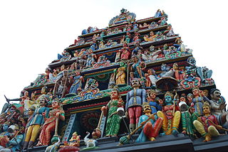
Built in the South Indian Dravidian style, this temple features a gopuram that rises above the main entrance along South Bridge Road. It is richly embellished with six tiers of sculptures of Hindu deities, other figures and ornamental decorations. The tower tapers up towards to a moulded ornamental ridge. The scale of each tier and its sculptures is slightly smaller than that of the tier immediately below it. This helps to create the illusion of height and adds to the symbolic importance of the building. Flanking the gopuram are a sculpture of Murugan on the right and Krishna on the left (as one enters). The sculptures are all of plaster, which allows for fine detailing. They are painted in a variety of bright colours, which adds to the visually spectacular quality of the gopuram.
The floor plan of the gopuram base block is rectangular and is bisected by an entrance passageway. The entrance contains a pair of very large double-leaf timber doors. The scale of these doors is intended to induce humility in the visitor and emphasise the diminutive human scale in relation to the divine. The doors are studded with small gold bells arranged in a grid pattern, which devotees are supposed to ring as they move through. Footwear is also stored around the entrance area, as it is not allowed within Hindu temples as a sign of respect.
The main entrance with the gopuram is only one of the entrances into the temple compound, which is surrounded by a perimeter wall. Side openings also exist, which open on to the flanking Pagoda Street and Temple Street. However, these are mainly used as service entrances, with all devotees and visitors entering through the gopuram doors. The compound wall is also decorated with ornamental mouldings, as well as figures placed on top of the wall at various points, including several prominent seated cow sculptures.
Within the walled compound, the temple comprises a combination of covered halls, shrines and service areas, as well as courtyards open to the sky. Leading directly from the gopuram entrance through a covered hall is the main prayer area, with richly ornamented columns and ceilings with frescoes. The ceiling paintings include a large mandala diagram.
Sri Srinivasa Perumal Temple or Sri Perumal Temple is one of the oldest temples in Singapore. It is located in Little India on Serangoon Road, where its tall Gopuram (tower) shows the different incarnations of Lord Vishnu. This large complex, dedicated to Vishnu, dates from 1855, but the 20-metres-tall Gopuram is a relatively recent addition, built in 1966 at a cost of S$300,000. The temple’s five-tier Gopuram was a donation from P.Govindasamy Pillai, one of the earliest Indian migrants who made good. He ultimately set up a chain of popular general goods stores in Little India and was known for his philanthropic works, a legacy continued by his sons today.
The area around the Perumal Temple was once filled with ponds and vegetable gardens. A stream used to lead into the temple and was an important source for devotees to ritually cleanse themselves before beginning worship. Inside the temple’s inner courtyard, a well marks the spot where the stream used to flow. There is also aTulasi (thulassi) (basil plant plant), the Hindus’ symbolic holy bush.
Inside the temple you will find a statue of Perumal, or Vishnu, his consorts Lakshmi and Andal, and his bird-mount, Garuda. Perumal Temple is at the centre of the Hindu trinity made up of Brahma the creator, Vishnu the preserver, and Shiva the destroyer. The temple is dedicated to Krishna, one of the incarnations of Vishnu. Perumal is another name for Krishna and statues of him – coloured blue to signify blue-blood – are everywhere in the temple. There are also statues, Lakshmi and Andal, the goddesses of wealth and beauty respectively, and of his mount, the mythical Garuda bird. The temple ceiling is dominated by a colourful circular pattern depicting the nine planets of the universe.
This temple is the starting point for devotees during the annual Thaipusam festival. Devotees, their tongues and cheeks pierced by great metal skewers supporting Kavadi (cage-like constructions decorated with wire and peacock feathers), make their way to the Chettiar Hindu Temple on Tank Road in this colourful procession. This is done in gratitude or supplication to Lord Murugan.
The Sri Thendayuthapani Temple, better known as the Chettiars’ Temple or the Tank Road temple, is one of the Singapore Hindu community’s most important monuments. It was gazetted as a national monument on 21 October 2014. It was built in 1859 by Nattukottai Chettiar community.
This Hindu temple, dedicated to the six-faced Lord Subramaniam (Lord Muruga), is at its most active during the festival of Thaipusam. It is here that hundreds of pilgrims, their bodies pierced by hooks, spears and spiked steel structures called kavadi, end their Kavadu Attam procession from the Sri Srinivasa Perumal Temple on Serangoon Road. This act of penance and propitiation is carried out by devotees in gratitude to Lord Subramanian or Murugan, son of Lord Siva, for granting their prayers. Facilities at the temple
Knowing the needs of the Singapore Hindu Community, the temple has a beautifully decorated and spacious wedding hall for conducting marriages and such functions.
Some highlights:
Fully renovated and Air-Conditioned Wedding Hall ( called as Kalyana Mandapam in Tamil)
One of the biggest Wedding Hall in Singapore
Beautifully decorated Alangara Mandapam
Seating Capacity of the hall is around 500
Capacity of the dining hall is around 300
Ample parking facilities
Temple Priests available for reciting Hindu Religious Mantras
Temple Religious Music is provided
Hindu Religious Utensils used in wedding rituals are provided
Centrally located and easily accessible from all parts of Singapore. Festivals
Sri Thendayuthapani Temple celebrates various festivals with pomp and splendour and every year six important festivals are celebrated, which are: ThaiPusam, LetchaArchanai for Meenakshi Amman & Durgai Amman, Navarathri, Skantha Shashti and Thiru Karthigai. Of which Thaipusam is a famous festival in South East Asia that attracts thousands of Hindu Devotees and hundreds of tourists to Singapore.
Source : Wikipedia
Step into one of Singapore’s oldest Hindu temples, the Sri Veeramakaliamman Temple, dedicated to the goddess and destroyer of evil, Sri Veeramakaliamman or Kali.
This distinctive landmark in the heart of Little India has fascinating stories to tell of colonial Singapore.
From its earliest days, it was linked with early migrant workers from India, who would have worshipped the goddess to feel safe in a new foreign land.
One of its first names was Soonambu Kambam Kovil, or the “temple at the lime village” in Tamil. Many Indians who prayed at the temple worked in lime kilns in the area. Lime was a building material used back then.
During the Japanese air raids in World War II, many people sought physical refuge at the temple as well as prayed for Kali’s protection. As luck – or fate – would have it, the temple and all its statues escaped the bombings unscathed.
In the 1980s, major reconstruction work took place, with a ‘Rajagopuram’ (front tower) added as well as eight main domes and several other minor ones. The annexe building was also built at the back of the temple.
It was again renovated in 1999, with the temple’s consecration ceremony taking place in 2000.
In June 2014, the temple had another consecration ceremony which marked the culmination of the major restoration works, as well as the construction of a new six-storey building with various new facilities including a wedding hall, multi-purpose hall and staff quarters.
With its colourful and intricate statues and detailing, the temple remains one of the most spectacular experiences in Singapore.
Source : yoursingapore.com
The building is constructed in the style of South IndianTamil temples common in Tamil Nadu India as opposed to the style of Northeastern Indian Kali temples in Bengal, where Her worship is extremely widespread but the style of temple construction differs considerably.
The church is about 2 km from McLeod Ganj, towards Forsythe Ganj.
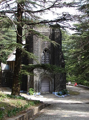
St. John’s Church in the Wilderness is an Anglican Church dedicated to John the Baptist built in 1852, located near Dharamsala, India, on the way to McLeodGanj, at Forsyth Gunj. Set amidst deodar forest, and built in neo – Gothic architecture, the church is known for its Belgian stained-glass windows donated by Lady Elgin (Mary Louisa Lambton), wife of Lord Elgin.
Though St. John’s Church in the Wilderness’ structure survived the 1905 Kangra earthquake, which killed close to 19,800 people, injured thousands in the Kangra area, and destroyed most buildings in Kangra, McLeodGanj and Dharamsala; its spire, Bell tower, was however destroyed. Later, a new bell, cast in 1915 by Mears and Stainbank, was brought from England and installed outside in the compound of the church.
Memorial
Grave memorial of James Bruce, 8th Earl of Elgin, Viceroy of India (1862–1863) at the church
Its churchyard is the final resting place of Lord Elgin, who served as Governor General of the Province of Canada, who oversaw the Creation of Responsible Government in Canada, and later, while in China, ordered the complete destruction of the Old Summer Palace. He became Governor-General & Viceroy of India in 1861 during the British Raj, though he soon died at Dharamshala on November 20, 1863, and was buried there.
There is a church by the same name in Nainital as well, built in 1844.
Click On The URL Or PICTURE for the complete News, Videos and more photos.
Saint Patrick’s Day, or the Feast of Saint Patrick, “the Day of the Festival of Patrick”), is a cultural and religious celebration held on 17 March, the traditional death date of Saint Patrick (c. AD 385–461), the foremost patron saint of Ireland.
Saint Patrick’s Day was made an official Christian feast day in the early 17th century and is observed by the Catholic Church, the Anglican Communion (especially the Church of Ireland), the Eastern Orthodox Church, and the Lutheran Church. The day commemorates Saint Patrick and the arrival of Christianity in Ireland, and celebrates the heritage and culture of the Irish in general. Celebrations generally involve public parades and festivals, cèilidhs, and the wearing of green attire or shamrocks. Christians also attend church services and historically the Lenten restrictions on eating and drinking alcohol were lifted for the day, which encouraged and propagated the holiday’s tradition of alcohol consumption.
Saint Patrick’s Day is a public holiday in the Republic of Ireland, Northern Ireland, the Canadian province of Newfoundland and Labrador (for provincial government employees), and the British Overseas Territory of Montserrat. It is also widely celebrated by the Irish diaspora around the world, especially in Great Britain, Canada, the United States, Argentina, Australia, and New Zealand. Saint Patrick’s Day is celebrated in more countries than any other national festival. Modern celebrations have been greatly influenced by those of the Irish diaspora, particularly those that developed in North America. In recent years, there has been criticism of Saint Patrick’s Day celebrations for having become too commercialised and for fostering negative stereotypes of the Irish.
Source : wikipedia
Opp. Post Office, St Francis Church Road, Fort Kochi, Kochi, Kerala 682001
Phone: 0484 221 7505
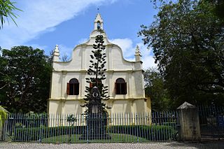
St. Francis CSI Church, in Fort Kochi (a.k.a. Fort Cochin), originally built in 1503, is the oldest European church in India and has great historical significance as a mute witness to the European colonial struggle in the subcontinent. The Portuguese explorer Vasco da Gama died in Kochi in 1524 when he was on his third visit to India. His body was originally buried in this church, but after fourteen years his remains were removed to Lisbon.
History
Vasco da Gama, who discovered the sea route from Europe to India, landed at Kappad near Kozhikode (Calicut) in 1498. He was followed by Pedro Álvares Cabral and Afonso de Albuquerque. They built Fort Emmanuel at the Fort Kochi Beach with permission from the Raja of Cochin. Within the fort, they built a church with a wooden structure, which was dedicated to St. Bartholomew. The neighbourhood is now known as Fort Kochi.
Francisco de Almeida, the Portuguese viceroy, was allowed, in 1506, by the Raja of Cochin to reconstruct wooden buildings in stone and masonry. The wooden church was rebuilt, presumably by the Franciscan friars, with bricks and mortar and a tiled roof was erected. In 1516, the new church was completed and it was dedicated to St. Anthony.
The Franciscans retained control over the church till the Dutch captured Kochi in 1663. While the Portuguese were Roman Catholics, the Dutch were Protestants. They demolished all the churches except this one. They reconditioned it and converted it into a government church.
In 1795, the British captured Kochi from the Dutch but they allowed the latter to retain the church. In 1804, the Dutch voluntarily handed over the church to the Anglican Communion. It was placed under the Ecclesiastical Department of the Government of India. It is believed that the Anglicans changed the name of the patron saint to St. Francis.
The Church was declared a protected monument in April 1923 under the Protected Monuments Act of 1904. As a protected monument it is under the Archaeological Survey of India but is owned by the Kochi diocese of Church of South India. It has services on Sundays and commemorative days. On weekdays it is kept open for visitors.
Source : wikipedia https://www.youtube.com/watch?v=NMglKcxGEHs https://www.youtube.com/watch?v=Rb7A_-NqKLc Reviews https://goo.gl/MVWbY3 Visiting hours : 07.00Am to 06.30Pm │ 08.30AM to 06.30PM (Sunday)
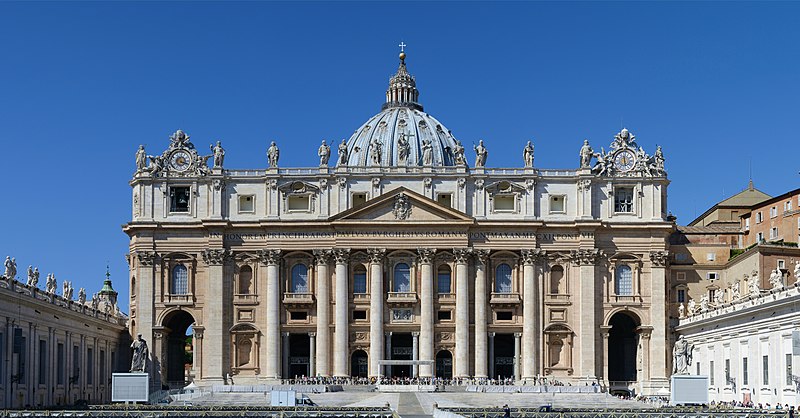
St. Peter’s Basilica, known in Italian as “Basilica di San Pietro in Vaticano,” is one of the most iconic and important religious buildings in the world. Located within Vatican City, an independent city-state enclave in Rome, Italy, St. Peter’s Basilica is a major pilgrimage site and a masterpiece of Renaissance and Baroque architecture. Here are some key facts about St. Peter’s Basilica:
Historical Significance: St. Peter’s Basilica is built on the site traditionally believed to be the burial place of Saint Peter, one of the twelve apostles of Jesus and the first Bishop of Rome. It has been a place of Christian worship for centuries.
Architectural Marvel: The basilica’s design is primarily attributed to the great Renaissance architects Donato Bramante, Michelangelo, Carlo Maderno, and Gian Lorenzo Bernini. It is a remarkable example of Renaissance and Baroque architecture.
Dome: The dome of St. Peter’s Basilica is one of its most distinctive features. Designed by Michelangelo, it rises to a height of 136 meters (446 feet) and is one of the largest domes in the world. Visitors can climb to the top of the dome for a panoramic view of Rome.
Interior: The interior of the basilica is lavishly decorated with marble, sculptures, and ornate artwork. The central nave is flanked by massive columns and has a stunning baldacchino (canopy) designed by Bernini over the papal altar.
Statue of St. Peter: Inside the basilica, there is a statue of Saint Peter, which is traditionally touched or kissed by pilgrims. This has resulted in the noticeable wear and tear on the right foot of the statue.
Papal Functions: St. Peter’s Basilica is often used for important papal functions, including liturgical ceremonies, blessings, and the election of new popes.
Vatican Grottoes: Beneath the basilica, there are the Vatican Grottoes, which house the tombs of numerous popes and other important figures of the Catholic Church.
Piazza San Pietro: The basilica is located in the famous St. Peter’s Square (Piazza San Pietro), which was designed by Gian Lorenzo Bernini. It is a large open space in front of the basilica where people gather for events and papal audiences.
Visitors: St. Peter’s Basilica is a major tourist attraction and an important religious site. Visitors can explore the basilica’s interior and, in some cases, attend papal audiences or Mass celebrated by the Pope.
Holy Door: St. Peter’s Basilica has a Holy Door, which is normally sealed and opened only during Jubilee years, as part of the Catholic Church’s holy year celebrations.
St. Peter’s Basilica is not only a religious and architectural marvel but also a symbol of the Vatican City and the Catholic Church. It continues to draw visitors and pilgrims from around the world who come to admire its beauty and historical significance.
St. Peter’s Square
St. Peter’s Square, known as “Piazza San Pietro” in Italian, is a large open space located in front of St. Peter’s Basilica in Vatican City, an independent city-state enclave within Rome, Italy. It is one of the most famous and recognizable squares in the world, known for its stunning architectural and historical significance.
St. Peter’s Square is not only a religious and architectural marvel but also a symbol of the Vatican City and the Catholic Church. It is a place where countless pilgrims and visitors gather to witness historical and religious events and admire the beauty of its design and symbolism.
St.Andrews Cathedral , Singapore’s largest cathedral is a stellar example of colonial-era architecture and heritage.
If you’re in the Civic District, you cannot miss the imposing tower and spire of St Andrew’s Cathedral. This is, after all, Singapore’s largest cathedral and the oldest Anglican house of worship.
Designed by Colonel Ronald MacPherson in 1856, an executive engineer and superintendent of the Public Works Department, the English Gothic structure replaced the original chapel which was destroyed by not one, but two lightning strikes in 1852.
Scottish merchants funded the early construction of the church building, so the church was named after the patron saint of Scotland. Trained Indian convict labourers were involved in the cathedral’s construction.
In 1942, shortly before the fall of Singapore during World War II, the cathedral was used as an emergency hospital during the frequent air raids. Church service resumed in 1945, after the Japanese surrendered.
Gazetted as a national monument in 1973, the cathedral and its grounds hold a number of memorials and dedications.
Among them, the stained glass windows in the apse are dedicated to Singapore’s founder, Sir Stamford Raffles; its second British Resident, John Crawfurd; and Straits Settlements Governor, Major-General William Butterworth. You can also find tablets commemorating victims of the 1915 Sepoy Mutiny in Singapore.
Pick up a tour pamphlet and visit this grand St.Andrews Cathedral at your own pace during opening hours. Free guided tours are also available, but do call beforehand.
Source : yoursingapore .com
Architecture
The existing St.Andrews Cathedral cathedral was designed in a Neo-Gothic architectural style, and was finished with Madras chunam. The architect is said to have drawn inspiration for aspects of the design from Netley Abbey, a ruined thirteenth century church in Hampshire, England. The piers of the nave of Saint Andrew’s closely resemble the surviving piers at Netley.
Three stained glass windows are dedicated to three figures in Singapore’s early colonial history: the window at the center is dedicated to Sir Stamford Raffles; the windows on either side to John Crawfurd, the first major Resident of Singapore, and Major General William Butterworth, the Governor of the Straits Settlements. These windows are located at the apse, however, the original stained glass windows were destroyed during the Second World War. MacPherson is remembered in the grey and red granite memorial monument surmounted by a Maltese cross in the grounds and by the stained glass window over the big west door. Jalan Klapa was renamed MacPherson Road in remembrance of his work. The gallery at the West end was not part of MacPherson’s plan but added after the Cathedral opened. It has the only decorated elements in the church, with foliated pillars and pilasters, and crocketed arches.
St. George Syro-Malabar Catholic Forane Church, popularly known as Edappally Mar Geevarghese Sahada Palli or Edapally Palli is situated in Edappally, Kochi, India. This is one of the oldest churches in India, built in 594 AD. It was originally dedicated to the Virgin Mary, called Marth Mariam in the vernacular. In 1080, a new church was built adjacent to the old church. Every year, a nine-day festival is celebrated here in the month of April – May. The church is also popular among the non-Christians as a pilgrimage centre and the popular offerings at the church are chicken and eggs.
History
The St. George Syro-Malabar Forane Church is known to have a history of 14 centuries. Edappally was then a small hamlet, a part of the princely kingdom of Elangalloor. The Syrian Christian congregation at Edappally was small in number and were the descendants of the people converted into Christianity by St. Thomas the Apostle who came to India in 52 AD.
Since the old church was found to be too small to accommodate the overgrown congregation, a new church was built in the present location in A.D. 1080. The main altar and the facade of this church was later renovated. The altar was renovated by incorporating the picture of Virgin Mary which was surrounded by sculptures, angels and vines. The facade also was renovated thirty years back, but the facade of the present day church is a return to the original one.
On 1 January 2001, at 8 A.M., the foundation stone, blessed by Pope John Paul II, was laid for the third church. This new church, which was consecrated in April 2015, has a combination of European and Keralite architectural features and is one of the largest in India with a built up area of over 88000 square feet. It can hold 5000 worshipers at a time in the main chapel measuring 19500 square feet. Vastushilpalaya, an architectural firm run by Koshy K. Alex and Zeril S. Jose, are the architects of the project. The church courtyard holds a well and the devotees believe the water in the well has curative powers.
Source : wikipedia https://www.youtube.com/watch?v=8kUjbvyb9HY https://www.youtube.com/watch?v=fRdjvNFDW5k https://www.youtube.com/watch?v=e11L5f_ihWk Reviews https://goo.gl/Ln8cpx Timings :https://goo.gl/Q993qr
Among the oldest churches in Kerala, the St.Mary’s Basilica Champakulam Church in Alappuzha is believed to be one of the seven established by St. Thomas in AD 427. Situated on the western bank of River Pamba, The annual feast of St.Mary’s Basilica Champakulam falls on the 3rd Sunday of October every year. The feast of St. Joseph is celebrated on March 19th. Nearby is a place that makes wooden statues of Christ to export around the world.
Source : keralatourism.org
Kalloorkadu St.Mary’s Basilica Champakulam (also called Champakulam Valia Palli) is one of the oldest Christian churches in India and the mother church of almost all Catholic Syrian churches in Alleppey District. It is the first one under the church at Niranam which is believed to have been founded by St.Thomas,the Apostle himself. Believed to be established in AD 427. Rebuilt many times and the many rock inscriptions found around the church tell us about the history of the church. The open air Rock Cross at Champakulam church is one of the most ancient ones with clear documentation of its antiquity up to AD 1151. There are many archaeological artifacts found around the church about its history. Champakulam church was once under Niranam Church, which was founded by the Apostle Saint Thomas himself.. Champakulam Church had very friendly relations with the Jacobite Syrian group and had a pivotal role in many ecumenical efforts in the Eighteenth century. One of the martyrs of east syrian catholics (nasranis), Ikkako Kathanar was born to this parish.
On 27-Nov-2016, the church was announced as a Basilica. This is the first basilica in the archdiocese of Changanasserry. So this is the 23rd basilica in India and 9th basilica in Kerala. Also, it is the 4th Syro-Malabar basilica in India.
Source : wikipedia
57, Lebuh Chulia, George Town, 10200 George Town, Malaysia
The “Kids on Bicycle” mural located at Lebuh Armenian is painted by Ernest Zacharevic, a young Lithuania-born artist. This photo of George Town is courtesy of TripAdvisor
Take an amazing tour around George Town to discover the unique painted walls mimicking life in the city and the wrought-iron caricatures with anecdotal descriptions of the streets that they adorn.
Blending humour and historical facts, these metal sculptures describe the prevailing colloquial demeanor of the early settlement days that gave memorable moniker to the streets and landmarks that are George Town icons today. Like voices from the past, they creatively symbolize the intimate relationship the people have in their daily lives with these landmarks that stand to this day.
Source : tourismpenang.net.my
An enjoyable way to spend a few hours in George Town is to follow the Penang Street Art trail, which takes you through the Historic UNESCO World Heritage Zone, in search of unique art murals and wrought-iron caricatures.
In 2012, Lithuanian born Ernest Zacharevic was commissioned to paint a few murals around the city to capture the spirit and lives of the local people. These fun and free-spirited murals proved to be quite a success as they were followed up with additional paintings from other artists contributing to a growing arts and culture scene throughout George Town.
Today, you can follow the ‘Penang Street Art’ and ‘Marking George Town’ trails, taking in various murals found on the sides of buildings, down small streets and some even within shops. The wrought-iron installations are found on the streets throughout city.
Of the Art Murals, the most enjoyable were ‘Kids on Bicycle’, ‘Old Motorcycle’ ‘Children Playing Basketball’ and some of the new murals spotted along Lebuh Cannon and Lebuh Armenian Streets.
Click On The URL Or Image for the complete News, Videos and more photos.
The World Photography Organisation is a global platform for photography initiatives. Working across up to 180 countries, our aim is to raise the level of conversation around photography by celebrating the best imagery and photographers on the planet. We pride ourselves on building lasting relationships with both individual photographers as well as our industry-leading partners around the world. Sony World Photography Awards
Free to enter and open to all photographers, the world’s largest photography competition celebrates its 10th anniversary in 2017. Winning photographers are flown to London to receive their prizes at the annual awards ceremony. Winning, shortlisted and commended photographers are showcased at the Sony World Photography Awards Exhibition each Spring in London, United Kingdom.
Source : worldphoto.org
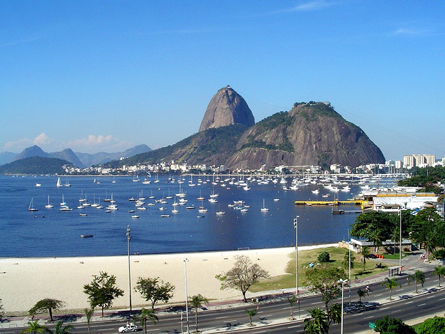
Urca, Rio de Janeiro – State of Rio de Janeiro, Brazil
Image Credit : commons.wikimedia.org/
Sugarloaf Mountain is a peak situated in Rio de Janeiro, Brazil, at the mouth of Guanabara Bay on a peninsula that juts out into the Atlantic Ocean. Rising 396 m (1,299 ft) above the harbor, its name is said to refer to its resemblance to the traditional shape of concentrated refined loaf sugar. It is known worldwide for its cableway and panoramic views of the city and beyond.
The mountain is one of several monolithic granite and quartz mountains that rise straight from the water’s edge around Rio de Janeiro. Geologically, it is considered part of a family of steep-sided rock outcroppings known as non-inselberg bornhardts.
The mountain is protected by the Sugarloaf Mountain and Urca Hill Natural Monument, created in 2006. This became part of a World Heritage Site declared by UNESCO in 2012.
Cable car
A glass-walled cable car, capable of holding 65 people, runs along a 1,400 m (4,600 ft) route between the peaks of Sugarloaf and Morro da Urca every 20 minutes. The original cable car line was built in 1912 and rebuilt around 1972–73 and in 2008. The cable car goes from a ground station, at the base of Morro da Babilônia, to Morro da Urca and thence to Sugarloaf’s summit.
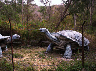
Shivalik Fossil Park, also known as the Suketi Fossil Park ,located at a distance of 22 kms from Nahan , is a fossil park with a collection of prehistoric vertebrate fossils and skeletons recovered from the upper and middle Siwaliks geological formations of sandstones and clay at Suketi in the Sirmaur district in the Indian state of Himachal Pradesh. The park has a display of the fossil finds and also an open-air exhibition of six extinct mammals formed in life-size models made of fiberglass, in a natural ambiance of the Sivalik Hills environment of the Plio-Pleistocene era (circa 2.5 million years) from where the fossils were unearthed. There is also a museum, within the precincts of the Suketi Fossil Park, where the fossils are curated and exhibited. It is Asia’s biggest fossil park. The exhibits in the park are used for generating scientific interest in the public and for facilitating special international studies by visiting research scholars from all over the world, apart from tourism development.
Location
The Suketi Fossil Park is named after the Suketi village where it is located, at the site where the fossils were found, in the Markanda River valley, at the foot of the Himalayas. It is at a distance of 22 kilometres (14 mi) southwest of Nahan, the district headquarters of Sirmaur district. Kala Amb, a small industrial town, is 5 kilometres (3.1 mi) away on the Kala Amb-Bikramabad road. The park, extensively forested, is spread out over an area of 1.5 square kilometres (0.58 sq mi) at Suketi. A tourism information desk is maintained at the park.
Features
The fiberglass models on display in an open area, outside the museum are of six extinct animals.They are: Huge land tortoise, gharial, four–horned giraffe, sabre-toothed cat, large tusked elephant, and hippopotamus.
The Saketi Park has a unique feature, in a miniature form, of the prehistoric biological record of the Upper Siwalik rocks, similar to those found in the Patwar Plateau and adjacent hills, also in Mangla dam areas in the region.
Models
The model of the sabre-tooth cat, almost similar to the present day species, is depicted with very long upper canine teeth, used to tear its prey. This animal became extinct about a million years ago; at the same time many species of elephants also became extinct. The hippopotamus model, made life-size similar to its present-day counterpart, has six incisors with a comparatively larger mouth but with a small brain hole, longer lower jaw and legs like the pig. This species, which existed in large numbers about 2.5 million years ago, is now extinct. The model of the giant land tortoise, representing a species found in the Shivalik region, is the largest of all tortoises but its present-day counterpart is much smaller. Models of the giant-sized elephants are of those which roamed 7 to 1.5 million years ago here, had a smaller cranium (bone portion of the skull), unusually long pair of tusks and huge limbs; these species numbering 15 vanished about 1.5 million years ago. The model of a four-horned giraffe, an ancestor of the present species, lived in the region 7 to 1.5 million years ago; it has an unusually large skull but a comparatively short neck. The models were initially within the park, however after the fire in jungle, few of the models were damaged and now the remaining ones are placed outside the museum.
Museum
The exhibits in the museum contain skeletal remains of different groups of skulls and limbs of mammals, skulls of hippopotamuses, tortoises, gharials and crocodiles, tusks of 22 species of elephants, rocks and charts and paintings related to the several aspects of plant and animal life of the past and present. The stone items on display belong to the Early Palaeolithic Man. Also preserved in the museum are fossils of two genera of extinct primates, Sivapithecus and Ramapithecus. The museum also houses antiquities unearthed by Captain Cautley in the area, from which he dug out the remains of Asia’s oldest human ancestor.
Exhibits also include an Indian postage stamp with images of two elephants and tusks, issued in 1951 on the occasion of the centenary of the Geological Survey of India.
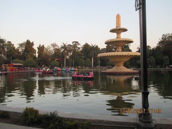
Sukhadia Circle(Square) is a popular recreational centre in Udaipur in Indian state of Rajasthan. It is a large roundabout in the city’s northern suburb of Panchwati, on the road to Ranakpur and Mt. Abu. It providing options for fast food centers, camel and horse rides, boat ride and kids play zone areas.
Sukhadia Circle is a small pond, at center of which lies lies a 21 ft high three-tiered fountain. The fountain is made of white marble, and is shaped like a wheat-ear motif, which stands as a symbol of prosperity. The pond offers boat ride, and options for camel and horse ride around the Sukhadia Circle are also available. It is also surrounded by many small gardens and food joints, and kids play-zone areas around it.
The Circle was built in 1968 and opened for public in 1970. It has been named after Late Mohan Lal Sukhadia, the ex-Chief Minister of Rajasthan and a native of Udaipur.
It is situated at city’s northern suburb of Panchwati, which is around 4.6 km from Udaipur City railway station. Visitors can take auto-rickshaws and taxis to reach Sukhadia Circle. There is no visiting fee for the fountain, while boat-ride and other rides has nominal charges.
Source : wikipedia
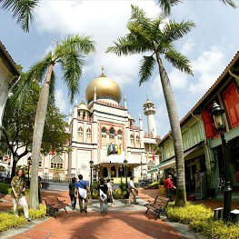
Also known as Masjid Sultan, the impressive Sultan Mosque in historic Kampong Glam is the focal point for Singapore’s Muslim community.
With its massive golden domes and huge prayer hall, Sultan Mosque is a must-see if you’re in the historic Kampong Glam district.
Masjid Sultan, as it is also known, is a prominent mosque in Singapore and one of the country’s most impressive religious buildings.
The Sultan mosque was built in 1824 for Sultan Hussein Shah, the first sultan of Singapore. Sir Stamford Raffles, the founder of Singapore, gave $3,000 to the construction of a single-storey building with a double-tiered roof.
A hundred years later, the old mosque was in desperate need of repair. The present mosque as you see it today was designed by Denis Santry from Swan and Maclaren, Singapore’s oldest architectural firm, and rebuilt in 1932.
A little-known fact is that during this reconstruction, North Bridge Road was actually forced to bend around the mosque as it was extended beyond Arab Street.
While you’re there, look closer at the onion domes. Each dome base is decorated with glass bottle ends, donated by poor Muslims during its construction so that all Muslims, not just the rich, could contribute.
Gazetted as a national monument in 1975, the mosque is a focal point for the Muslim community then as now. If you’re there during Ramadan, the Muslim month of fasting, check out the night market in the area and its many food stalls.
And do hop on the mosque’s informative guided tours – guides can speak English, Malay, Chinese, and even Japanese.
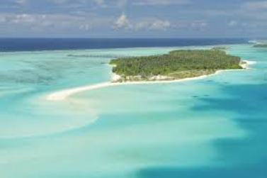
The Maldives are a group of islands in the Indian Ocean. They are southwest of India. They are made up of the Maldive and Suadive archipelagos, with over 1,200 islands. These islands are a part of 26 atolls. People live on about 200 of the islands. It has more than 1126 coral reefs. It is the flattest country in the world. The highest point in the Maldives is only 2 m (7 ft) high above the level of the sea.
Sun Island set in the magnificent island of Nalaguraidhoo, will capture your heart with its exotic tropical flowers and beautiful greenery in the gardens that takes you to the purest of stunning blue sapphire lagoons. Located 62 miles from the male’ airport, Nalaguraidhoo is the most breathtaking and picturesque island in South Ari Atoll.
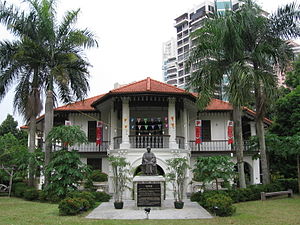
The Sun Yat Sen Nanyang Memorial Hall , is a two-storey colonial style villa in Balestier, Singapore. The villa is now a museum commemorating Sun Yat-Sen, the founding father of the Republic of China, who visited Singapore nine times between 1900 and 1911.
The villa is now home to a collection of close to 400 artefacts, including calligraphy works, photographs, old books, paintings, sculptures & etc., all spread over the five galleries in two levels. The villa is redecorated in the style of an old Peranakan house and has 180 new artefacts added. Most of the paintings, the bronze wall mural, and the bronze statues and busts, worth over S$1.5 million,which were commissioned by the museum, were paid for by the Lee Foundation
Highlights
A two-metre tall bronze wall mural which spans 60 metres to the back of the building and depicts Singapore’s history from the 1840s to the 1940s. It was sculpted by artists from China between 1999 and early 2005 at a cost of around S$1 million. It depicts scenes of Singapore as a fishing village in the 1840s and the Sook Ching Massacre in 1942.
Bronze statues scattered around the garden, including those of persons who helped Sun Yat-sen in the Xinhai Revolution. There is a one-metre tall sculpture of Sun Yat-sen seated on a chair, which was presented by the Chinese government in 1937. More bronze sculptures of Sun line the hallway leading to the museum’s entrance.
Oil and watercolour paintings and calligraphy works by Singaporean and Chinese artists, such as painter Liu Kang, Buddhist monk and artist Reverend Song Nian, and Cultural Medallion -winning artists Ong Kim Seng and Tan Swie Hian. These are found in the galleries on level two.
Photograph of Sun Yat-sen and members of the Tongmenghui’s Singapore branch, taken at Wan Qing Yuan around 1906.
Sundar Nagar located 25 kms from mandi, is a City and a municipal council in Mandi district in the Indian State of Himachal Pradesh. Formerly it was a princely state, known as Suke
There is a mixture of Himachalis and other states people in this town. This is due to the presence of the Bhakra Beas Management Board (B.B.M.B), which is a Govt. of India project having Punjab, Haryana, Rajsthan and Himachal Pradesh as partners and hence the employees are mostly from Punjab, Haryana and Rajsthan. Now the number of people from Bihar are also increasing due to different construction works going on (mainly houses).
The place as a whole is quite peaceful. There are lot of scenic beauties to see like sunset across the lake, valley view from the road going to Keran etc. There are two open big grounds in the colony where a lot of children play, people usually go for a walk in the evenings and mornings, usually on the roads towards nearby villages like Chambi and Keran.
Sundar Nagar has emerged as an educational hub in past few years, having an Government Engineering College, Government Dental college, Government Polytechnic College, Government Sanskrit College and Semi Government Degree College.
S Street Rd, opposite Pension Treasury, Fort, East Fort, Pazhavangadi, Thiruvananthapuram, Kerala 695023
Phone: +91 94473 41974
Wax sculptor Sunil Kandalloor brings Sunil’s Wax Museum
“Kabali da!” The dialogue pops up in my mind while standing next to a wax model of Rajinikanth at the newly-opened Sunil’s Wax Museum in the city. One can’t miss the swag and style of the superstar in Kabali. Seated next to him is Mohanlal as Stephen Nedumpally from his mega hit Lucifer.
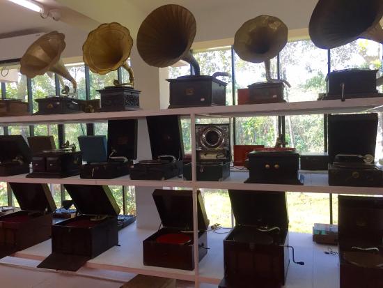
The remarkable collector Sunny Mathew has over 1 lakh (100,000) rare records, including records in their earliest form and about 260 gramophones/record players/phonographs of different varieties in his self-built Discs and Machines Museum, in Kottayam, Kerala. It is a shrine for music lovers and students of history of sound recording. M Dharma Kirthi, Sundeep Pahwa and Rocky Abraham find themselves transported into a mesmerising world of discs, gramophones and record players, painstakingly collected, archived and preserved by an unassuming, retired Forest Officer, Sunny Mathew. Dharma Kirthi chronicles this amazing journey of discovery as Sunny Mathew takes the visitors through his collections and creations with passion, energy and enthusiasm.
Source : learningandcreativity.com
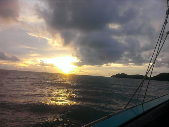
Langkawi Sunset Cruise is a mid-afternoon daytrip that takes you sailing on the Andaman Sea as you kick back and relax on board a yacht. The upscale adventure starts off at the Awana Porto Malai jetty; once on board, there is an open bar with chilled soda, fruit juice, wine, and beer. The cruise takes you within almost-touching distance of some of Langkawi’s deserted islets – unique limestone outcrops and exotic marine life are part and parcel of the voyage. Friendly yacht staff top up drinks and generally encourage a boisterous time. The million-dollar moment happens when the sun sets on the horizon and you are lounging in a deck chair with a cold drink.
Source : langkawi-info.com
Try out this four hour Cruise which is an awesome experience. Trip to Langkawi is not complete without the cruise. The cruise takes you within almost-touching distance of some of Langkawi’s deserted islets – unique limestone outcrops and exotic marine life are part and parcel of the voyage.
Sunset Point, located in South West of Nakki Lake provides you a scenic view of the setting sun. Hundreds of people swarm this area in the evening amidst a carnival atmosphere. Food stalls, souvenir shops abounds the area. The scenic hills, tranquil surrounding, and the pleasant climate makes it a favorite spot of the tourists. The Honeymoon Point located close by is another attraction of Mount Abu. Itis a good place to pick up trinkets and knick knacks. Carved marble statues, sandalwood idols, wooden toys and the likes can be seen all over the spot.
3, Jalan PJS 11/11, Bandar Sunway, 47500 Selangor Darul Ehsan,Malaysia.
Phone : +603 5639 0182
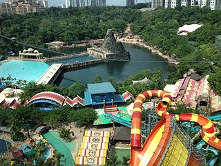
The Sunway Lagoon is a theme park in Subang Jaya, Selangor,Malaysia. It was officially opened on 29 April 1993 (17 September 1997). It is a multipark extravaganza, with 80 attractions spread over 360,000 square metres (89 acres; 36 hectares). It features rides in both the water park and the adjacent amusement park, excluding Scream Park, Wildlife Park & Extreme Park. In late 2008, new parks were added and minor improvements were made to the existing park.
In 2016, TripAdvisor Travellers’ Choice awards ranked Sunway Lagoon at number 5 in its Asia’s Top Water Parks ranking.
Sunway Lagoon became the official theme park in Malaysia of UEFA Euro 2016.
Extreme Park has a variety of activities, including rides and games of skill.
Scream Park provides an interactive “scare” experience by using audio and visual effects and live actors.
Sunway Lagoon is one of the world’s largest man-made surf beach, a title recognized by the Malaysia Book of Records.
Wildlife Park is an interactive and educational zoo with exotic, small and friendly animals from a range of birds, reptiles and mammals. The Wildlife Park is home to more than 150 species, with the pygmy marmoset and white lions among its latest additions.
Each of the animal sanctuaries has a different name such as Pet Village, Jungle Trail, Aviary, Tropical Enclosure, Tree Top Terrace and Bird Savannah.
The new Nickelodeon themed attraction was opened on 2 February 2016.[6] The development costs RM 100 million and is expected to attract 2 million visitors to Sunway Lagoon in 2016.[7] The attraction is the first Nickelodeon-themed land in Asia.[8] The new attractions feature 14 immersive attractions, some of which are built around Nickelodeon properties, including SpongeBob SquarePants, Dora the Explorer and Teenage Mutant Ninja Turtles, as well as a daily signature slime event, waterslide rides, retail shops and more.
Syntagma Square is the central square of Athens. The square is named after the Constitution that Otto, the first King of Greece, was obliged to grant after a popular and military uprising on 3 September 1843.
It is located in front of the 19th century Old Royal Palace, housing the Greek Parliament since 1934. Syntagma Square is the most important square of modern Athens from both a historical and social point of view, at the heart of commercial activity and Greek politics. The name Syntagma (Greek: Σύνταγμα) alone also refers to the neighbourhood surrounding the square.
The square is located near many of Athens’ oldest and most famous neighbourhoods and tourist attractions, all within walking distance.
The Old Royal Palace neoclassical building, housing the Greek Parliament since 1934, is immediately across Amalias Avenue to the east, and surrounded by the extensive National Gardens, which are open to the public; the Parliament itself is not open to the public, even when not in session. Every hour, the changing of the guard ceremony, performed by the Presidential Guard, is conducted in front of the Tomb of the Unknown Soldier on the area between the Syntagma Square and Parliament building. On certain days, a ceremonial changing of the guard occurs with an army band and the majority of the 120 Evzones present at 11 am.
Tabo Monastery (or Tabo Chos-Khor Monastery is located in the Tabo village of Spiti Valley, Himachal Pradesh, northern India. It was founded in 996 CE in the Tibetan year of the Fire Ape. by the Tibetan Buddhist lotsawa (translator), Rinchen Zangpo (Mahauru Ramabhadra), the king of western Himalayan Kingdom of Guge. Tabo is noted for being the oldest continuously operating Buddhist enclave in both India and the Himalayas. A large number of frescoes displayed on its walls depict tales from the Buddhist pantheon. There are many priceless collections of thankas (scroll paintings), manuscripts, well-preserved statues, frescos and extensive murals which cover almost every wall. The monastery is in need of refurbishing as the wooden structures are aging and the thanka scroll paintings are fading. After the earthquake of 1975, the monastery was rebuilt, and in 1983 a new Du-kang or Assembly Hall was constructed. It is here that the 14th Dalai Lama held the Kalachakra ceremonies in 1983 and 1996.The monastery is protected by the Archaeological Survey of India (ASI) as a national historic treasure of India.
Tabo Monastery (Tabo ‘Chos-hKhor’ or Doctrinal Enclave now has nine temples, four decorated stupas, and cave shrines. The paintings date to the 10th-11th centuries for main temple (Tsug la Khang), 13th-14th centuries for the stupas, and from the 15th to the 20th centuries for all the other temples. Yeshe-Ö and his two sons when they built the monastery in 996 AD blended the provincial and regional characteristics with that of India and Central Asia. One particular feature mentioned in this regard is the iconographic themes of non-Buddhist traditions emanating from the protectress deity Wi-nyu-myin. The main temple is conjectured to represent the entire Vajradhatu Mandala.The monastery has a huge collection of manuscripts and Pramana texts, which were filmed between 1991 and 1998.
Many festivals are held in the precincts of the monastery. The Tibetan monks perform traditional Buddhist and regional songs and dances. The most popular religious festival held here is the Chakhar Festival, which is dedicated to the peace and happiness of all. This is held every three years, usually during September or October. On this occasion, religious masked dances, songs and general festivities are the main events.
Source : wikipedia
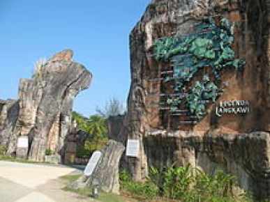
Taman Lagenda or Legend Park is a recreational area opened on 27 April 1996 dedicated to Langkawi’s heritage of myths and fables. The park covers an area of 20 hectares of reclaimed land, and is more of an open-air ‘garden museum’ featuring sculptures, scenic gardens, ponds and fountains, and fruit trees growing around pathways and along the ponds.
Along with the flowering vegetation, the park has 17 sculptures that depict the many legends found in Langkawi, such as the duel between two giants that led to the formation of Mat Cincang and Raya Mountains, mythical birds and fairy-tales of princesses. In addition, there are 4 artificial lakes and a man-made beach to complement the picturesque scenery. The park is open from morning till late at night and is within walking distance from the jetty.
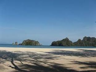
Located about 20 kms. from Kuah town, just beyond Pantai Pasir Hitam, Tanjung Rhu Beach is one of Langkawi’s best shorelines. The waters are as clear as crystal, the sand is powder-fine and you have to drive through dense forests to reach here. The area is absolutely secluded and the atmosphere is silent and peaceful. A nature lover’s paradise, Tanjung Rhu has centuries-old limestone caves, mangroves and waterways. The blue waters of the ocean will tempt you into taking a swim and exploring the rich coral and marine life.
Located just beyond Pantai Pasir Hitam, Tanjung Rhu Beach has one of Langkawi’s best shorelines. The waters are as clear as crystal, the sand is powder-fine and driving towards this beach you’ll have to pass a dense corridor of jungle. The area is absolutely secluded and the atmosphere is silent and peaceful. Bordered by intermittent limestone crags, Tanjung Rhu is gorgeously breathtaking and even though it may be as hot as Hades in some of the other areas of Langkawi, here the air is crisp, clean and cool. There are a few roadside stalls selling Langkawi’s local favourite – mee gulung – but other than that the area is quiet. Featuring clean roads, this quarter of Langkawi Island is the domicile of the Tanjung Rhu Resort as well as the Four Seasons Resort and the well-heeled tend to gravitate here.
Source :langkawi-info.com
Maa Bhagwati Tara Devi temple is located on Tarav Parvat in the western side of shimla Town about 15 Km from Shimla situated by the side of Kalka- Shimla National Highway near Shoghi. The road meandering uphill through the sweet smelling pine forests and lush green meadows with the cool gentle breeze touching one softly infusing a freshness and vigor in the devotees, pilgrims and tourists visiting this holy shrine. The location of the temple on the Hill top makes it appear that the goddess Maa Tara Devi seems to keep everyone under the protective gaze ,showering innumerable blessings on her worshippers. The picturesque view from the temple is indeed breath taking and captivating with the superb panorama of the lofty and majestic forested mountains around, which offers a calm peaceful and tranquil countryside, a site that has a soothing and rejuvenating effect, being away from the din, pollution and the taxing effect of a fast urban life style.
Tattapani village is located in Mandi district at a distance of 51 km from Shimla and 29 km from Naldehra. It is situated on the right bank of river Sutlej at an altitude of 2,230 ft. above the sea level. In local language, ‘Tattapani’ means ‘hot water’. The place is famous for its hot water springs that is spread over an area of one square kilometre. It’s pure water is rich in sulphur content and is believed to have curative power for various kinds of bodily and skin diseases.
Tourists can visit a popular Hindu religious place called Shivji Ka Gufa (Shiva’s cave) which is just 4 km away from Tattapani. Adventure lovers can go for white water rafting on Sutlej river. One can also enjoy a bonfire with family or friends at night along the river side. Visitors can get accommodation at various guesthouses, budget hotels and luxury resorts that are located nearby.
Source : goibibo.com
Tattapani can be visited all the year round, especially in winters when the sulphur springs make the place a little warm.
Interestingly, the sulphur springs disappear when the level of the Sutlej rises in June-July and reappear in November-December.
Tazia Tower of Jaisalmer is one of the major tourist attractions. It is situated in the excellent ‘Badal Palace’ complex located near Amar Sagar Gate. These were the homes of the former royal family. The tower is a 5-storied structure where each story has significance in its own. On each floor there is a balcony that is famous for their individual designs. This was built by Muslim craftsmen and is based on the shape of Tazia. Tazia is actually the replica of Mausoleum of various Imams. They are made of wood, thermocol and colored papers. The architects gifted it to the then royal patrons.
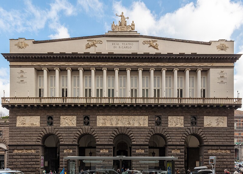
The San Carlo Theatre, known in Italian as “Teatro di San Carlo,” is an historic and renowned opera house located in Naples, Italy. It is one of the oldest continuously active opera houses in the world and holds a special place in the history of opera and classical music. Here are some key details about the San Carlo Theatre:
History: The San Carlo Theatre was founded in 1737 by King Charles VII of Naples and is named in his honor. It is the oldest opera house in Europe, predating the Teatro alla Scala in Milan and the Teatro La Fenice in Venice.
Architecture: The theater is known for its stunning Neoclassical architecture, designed by architect Giovanni Antonio Medrano. Its grand façade, opulent interior, and impressive Royal Box are iconic features.
Acoustics: San Carlo Theatre is renowned for its excellent acoustics, making it an ideal venue for opera and classical music performances.
Opera Performances: The theater has a long tradition of hosting world-class opera performances. Over the years, it has been the stage for many famous opera composers and singers.
Ballet and Concerts: In addition to opera, the San Carlo Theatre also hosts ballet performances and classical concerts, further contributing to its cultural significance.
Museum: The theater has an associated museum, Museo del Teatro di San Carlo, where visitors can explore the history of the theater, view costumes, and learn about its performers and productions.
Location: The theater is centrally located in the heart of Naples, near the Piazza del Plebiscito and the Royal Palace.
Guided Tours: The theater often offers guided tours, allowing visitors to explore its beautiful interiors, including the Royal Box and the stage, and learn about its rich history.
If you are a fan of opera, ballet, or classical music, or if you appreciate architectural and cultural heritage, a visit to the San Carlo Theatre in Naples is a must. It continues to be a cultural gem and a testament to Naples’ enduring passion for the performing arts. Be sure to check the official website of the San Carlo Theatre for the latest information on performances, tickets, and guided tours.
Source : openai.com Visiting hours : Monday to Saturday from 10.30 am to 12.30 am and from 14.30 pm to 16.30 pm. On Sunday from 10.30 am to 12.30 pm. Entrance fee : Adults: € 9 (US$ 9.50).
Young people under 30/seniors over 60: € 7 (US$ 7.40).
Children under 10 years old: € 4 (US$ 4.20).
Telaga Tujuh Waterfalls is considered as Langkawi Island’s most beautiful natural attraction. Its name means Seven Wells Waterfalls, referring to a series of seven connected natural pools fed by seven separate waterfalls in Mount Mat Cincang. At Telaga Tujuh, there are two viewing areas – one at the base of the waterfall and the other at the higher area where the seven pools are situated. It is said that the Telaga Tujuh Waterfalls are home to fairies and they used to come down to the pools to bath. To get to the seven pools, you have to climb around 300 steps.
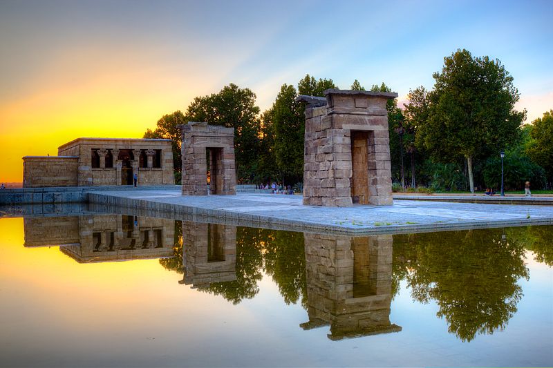
The Temple of Debod is an ancient Egyptian temple that was dismantled and rebuilt in Madrid, Spain.
The shrine was originally erected 15 kilometres (9.3 mi) south of Aswan in Upper Egypt, very close to the first cataract of the Nile and to the great religious center in Philae dedicated to the goddess Isis. In the early 2nd century BC, Adikhalamani (Tabriqo), the Kushite king of Meroë, started its construction by building a small single-room chapel dedicated to the god Amun. It was built and decorated in a similar design to the later Meroitic chapel on which the Temple of Dakka is based. Later, during the reigns of Ptolemy VI, Ptolemy VIII, and Ptolemy XII of the Ptolemaic dynasty, it was extended on all four sides to form a small temple, 12 by 15 metres (39 ft × 49 ft), which was dedicated to Isis of Philae. The Roman emperors Augustus and Tiberius completed its decorations.
From the quay, there is a long processional way leading to the stone-built enclosure wall, through three stone pylon gateways, and finally to the temple itself. The pronaos, which had four columns with composite capitals, collapsed in 1868 and is now lost. Behind it lay the original sanctuary of Amun, the offering table room and a later sanctuary with several side-rooms and stairs to the roof.
In 1960, due to the construction of the Aswan High Dam and the consequent threat posed by its reservoir to numerous monuments and archeological sites, UNESCO made an international call to save this rich historical legacy. As a sign of gratitude for the help provided by Spain in saving the Abu Simbel temples, the Egyptian state donated the temple of Debod to Spain in 1968.
The temple was rebuilt in one of Madrid’s parks, the Parque del Oeste, near the Royal Palace of Madrid, and opened to the public in 1972. The reassembled gateways have been placed in a different order than when originally erected. Compared to a photo of the original site, the gateway topped by a serpent-flanked sun was not the closest gateway to the temple proper. It constitutes one of the few works of ancient Egyptian architecture that can be seen outside Egypt and the only one of its kind in Spain.
Source : wikipedia https://www.youtube.com/watch?v=dwKQyk2G3Xo https://www.youtube.com/watch?v=7sK1bo69xXo https://www.youtube.com/watch?v=makqVkANfYw Reviews http://bit.ly/2GrNkhP Visiting hours : 1 April to 30 September
Tuesday to Friday, from 10:00 a.m. to 2:00 p.m. and from 6:00 p.m. to 8:00 p.m.
1 October to 31 March
Tuesday to Friday, from 9:45 a.m. to 1:45 p.m. and from 4:15 p.m. to 6:15 p.m.
Saturdays and Sundays, from 10:00 a.m. to 2:00 p.m.
This monument is closed on mondays and public holidays. Entry : Free entry
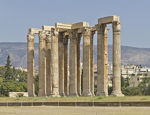
The Temple of Olympian Zeus, also known as the Olympieion or Columns of the Olympian Zeus, is a former colossal temple at the center of the Greek capital Athens. It was dedicated to “Olympian” Zeus, a name originating from his position as head of the Olympian gods. Construction began in the 6th century BC during the rule of the Athenian tyrants, who envisaged building the greatest temple in the ancient world, but it was not completed until the reign of the Roman Emperor Hadrian in the 2nd century AD, some 638 years after the project had begun. During the Roman period the temple, which included 104 colossal columns, was renowned as the largest temple in Greece and housed one of the largest cult statues in the ancient world.
The temple’s glory was short-lived, as it fell into disuse after being pillaged during a barbarian invasion in 267 AD, just about a century after its completion. It was probably never repaired and was reduced to ruins thereafter. In the centuries after the fall of the Roman Empire, it was extensively quarried for building materials to supply building projects elsewhere in the city. Despite that, a substantial part of the temple remains today, notably sixteen of the original gigantic columns, and it continues to be part of a very important archaeological site of Greece.
Click On The URL Or Image for the complete News, Videos and more photos.
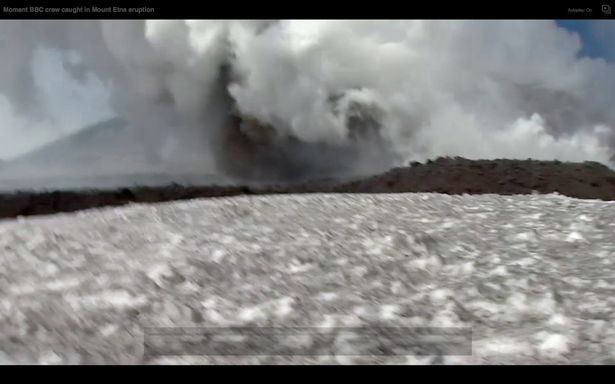
Mount Etna Volcanos is one of the most active volcanoes in the world and is in an almost constant state of activity. The fertile volcanic soils support extensive agriculture, with vineyards and orchards spread across the lower slopes of the mountain and the broad Plain of Catania to the south. Due to its history of recent activity and nearby population, Mount Etna Volcanos has been designated a Decade Volcano by the United Nations. In June 2013, it was added to the list of UNESCO World Heritage Sites.
Etna is one of Sicily’s main tourist attractions, with thousands of visitors every year. The most common route is through the road leading to Sapienza Refuge ski area, lying at the south of the crater at elevation of 1910 m. From the Refuge, a cableway runs uphill to an elevation of 2500 m, from where the crater area at 2920 m is accessible. Stage 9 of the 2011 Giro d’Italia finished at the Sapienza Refuge. Alberto Contador initially took the win, but he was later disqualified and the stage win passed onto Jose Rujano. Stage 4 of the 2017 Giro d’Italia will also finish at Sapienza, the other ski resort is Etna Nord-Linguaglossa.
Ferrovia Circumetnea – Round-Etna railway – is a narrow-gauge railway constructed between 1889 and 1895. It runs around the volcano in a 110-km long semi-circle starting in Catania and ending in Riposto 28 km north of Catania.
There are two ski resorts on Etna: one at the Sapienza Refuge, with a chairlift and three ski lifts, and a smaller one on the north, at Piano Provenzana, with three lifts and a chairlift.
Source : wikipedia https://goo.gl/Xv9cGa
Thamaramkulankara Road, Kottakakom, Thrippunithura, Kochi, Kerala 682301
Image Credit : youtube
Thamaramkulangara Sree Dharma Sastha temple is one of the most prominent temple in the royal city of Tripunithura, Kerala, India. It is dedicated to Lord Ayyappa worshiped as Dharmasastha.
Origin
According to anecdotes Lord Dharma Sastha of Chamravattom (in Malappuram District) followed one of his priests from Morakkala Mana who had shifted to Tripunithura. Lord Dharma Sastha assumed the form of a lizard and came with the priest comfortably by sitting on his traditional umbrella made up of palm leaves. Since then Lord Ayyappa is worshiped here bringing prosperity to the place.
History
The temple was initially owned by Morakkala Mana, but the prosperity of family was challenged and the day-to-day affairs were in question. The high priest finally approached the Maharajah of Cochin and handed the temple over to him in the 1930s. The King ordered the renovation of the temple and the Nithya Nidhanam (daily pooja) was funded by Nadumittom Devasom. This state of affairs continued with minor changes until the Fall of the Kingdoms when India got Independence. Again the temple affairs was in disarray.
In 1953 the youth in and around the temple came together for the betterment of the temple, precincts and restart the temple festival. This movement strengthened up with time, involving in many activities. These people in 1963 formed the Thamaramkulangara Ayyapa Seva Samithy (TASS). TASS spearheaded a development campaign which drove a dramatic rise of the temple from obscurity to center stage of temple landscape in Ernakulam. In 1984 with others, the temple was transferred to Kerala Uranma Devaswom Board.
Upadevathas
Besides Dharmasastha devotees also worship Lord Ganesha and Bhadrakali along with Nagaraja and Brahmasrakshas. Separate rituals and pooja is performed as required to these Upadevathas also.
Makaravilakku
Makaravilakku, the annual festival of this temple, bears a unique status. It occurs in January. As per the Malayalam era, the first day of the Makaram Month is celebrated as the Makaravilakku in the temple. Thamaramkulangara Ayyappa Seva Samithy organises the events of Makaravilakku in a way to keep the holiness of the temple precincts. The six days of celebrations begins with the Holy Flag hoisting (Kodiyettam) by chief priest (Thantri) five days before the Makaravilakku day.
Festivals
Thamaramkulangara Sree Dharmasastha temple celebrates many festivals apart from Makaravilakku. Some of them are:[2]
Dwaja Prathishta Dinam is the anniversary of the erection of the Holy Flag Post (Kodimaram) in the temple. It is celebrated every year on Meenam 14th as per Malayalam calendar.
Painguni Uthram is the birthday of Lord Sree Dharmasastha. Uthram star in the month of Meenam, as per Malayalam era is celebrated as Painguni Uthram.
Vishu is celebrated on the first day of Medam as per Malayalam Calendar. This year it will be celebrated on Friday,14 April by conducting Maha Ganapathy Homam.
The temple is decorated with flowers and traditional oil lamps in the last day of the Karkidakam month of the Malayalam calendar. This day is celebrated as the Karkidaka Niramala.
Navarathri is celebrated in the temple on the Durgashtami, Mahanavami and Vijayadasami day every year with cultural programmes that cultivates Bhakthi in the temple precincts and Vidyarambham is performed in the temple on VijayaDasami day. It is considered to be very auspicious to have Vidyarambham in front of Lord Sree Dharmasastha.
Mandalavilakku is celebrated on the 41st day of the Mandalakaalam. Mandalakaalam begins on the first day of Vrischikam. This signifies the end of Mandala Vratham, a mandatory prerequisite to visit the sacred Lord Ayyappa temple at Sabarimala.
Sasthaam Paattu is a traditional art form found in the central Kerala. It is also known as Ayyappan Paattu. It is a musical art form in which a team of people sing, songs praising Lord Ayyappa by playing a unique percussion instrument called ‘Udukku’. The main attraction among the songs is the song that describes the birth of Lord Ayyappa.
In Thamaramkulangara, Sasthaam Paattu is performed on the first Saturday of Vrischikam as per the Malayalam era. In the noon of same day, Annadhaanam is performed by devotees and TASS volunteers to all the devotees, which has a unique menu and is popular.
Source : wikipedia https://www.youtube.com/watch?v=uScAykus-0I
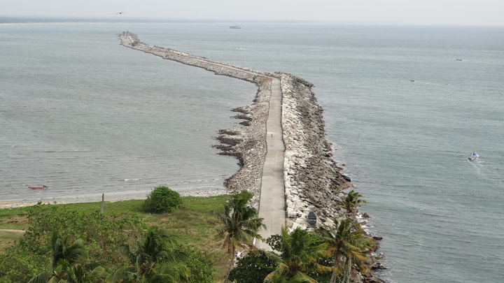
Thangasseri or ‘Dutch Quilon’ as it was called, was once a British enclave. Meaning ‘gold village’ in local parlance, this was the hub of a flourishing trade that used gold as currency. This seaside village of historic importance shelters the ruins of an old Portuguese fort and churches built during the 18th century. It is situated 5 km away from Kollam town in the state of Kerala.
The famed lighthouse of Thangasseri was built in 1902 and stands 144 ft high. The beacon can be seen up to 13 miles out at sea. Check out the lighthouse at Thangasseri which is open to visitors from 15.30 – 17.30 hrs.
Get to see the sun setting and the moon rising simultaneously at Thangasseri on the drive down the Lighthouse Road, which gives you a breathtaking view of the sea as well.
Source : keralatourism.org
The Thangassery beach is a 3km stretch of pristine white sands and shallow waves that make it perfect for splashing and swimming. The backdrop of tall swaying coconut trees makes for a relaxing backdrop to the serene, quiet beach. The 3km long breakwater along the beach is a major attraction and a ride along it can improve on the enchantment quotient!
The Thattekkad Bird Sanctuary, covering an area of barely 25 km2, and located about 12 km from Kothamangalam (Kerala state, India), was the first bird sanctuary in Kerala. Salim Ali, one of the best known ornithologist described this sanctuary as the richest bird habitat on peninsular India. Thattekkad literally means flat forest, and the region is an evergreen low-land forest located between the branches of Periyar River, the longest river in Kerala.
The Thattekkad Bird Sanctuary has a rich and varied birdlife. Several species of birds, both forest birds as well as the water birds, visit the sanctuaries, and the important ones include the following:
The Indian pitta, which visits the sanctuary during winter and spends almost six months here.
The sanctuary is a habitat for different varieties of cuckoos and a region of the sanctuary popularly called “Cuckoo Paradise” is home to them, among which are the:
Drongo cuckoo, which may be easily mistaken for drongo,
Indian hawk cuckoo, which is highly vocal, and the
Large hawk cuckoo, which looks relatively massive compared to other types of cuckoos, and is characterized by a dark grey and heavily streaked throat.
The Edamalayar forest is located about 15 km from Thattekkad Bird Sanctuary. This is also an evergreen forest located above the Edamalayar River. The mountain hawk eagles are found in this forest. Other birds in this forest include dark-fronted babbler, brown-cheeked fulvetta, brown-backed and white-rumped needletails, and emerald green pigeons.
Source : wikipedia https://www.youtube.com/watch?v=g0nQqzVInzM
River Bank Road, Thazhathangadi, Kottayam, Kerala 686005
Image Credit : keralatourism.org
Thazhathangady Juma Masjid is a mosque situated in Thazhathangady, one of the Heritage Zones of Kerala, India, near the town of Kottayam. It is one of the oldest mosques in India and is more than 1000 years old. It is famous for its richness of architecture, wood carvings and the beauty. Southern half of it is demolished and extended with iron pillars, aluminium sheets and minars in 2012. This mosque is situated on the banks of the Meenachil river.
Thazhathangady Juma Masjid is also called as the “Taj Juma Masjid”. The ancestors of this Masjid came and settled in Kottayam, from different parts of Kerala.The Muslims who lived here played an active role in Freedom Struggle and other National Movements.
This mosque is known for its intricate wooden carvings and architecture.
Source : wikipedia https://www.youtube.com/watch?v=k0c4E6IP_kk https://www.youtube.com/watch?v=xnCnvnhxUpI Reviews https://goo.gl/DG7l1y Timings : 0700 – 1800 hrs
Click On The URL Or PICTURE for the complete News, Videos and more photos.
A yacht is a recreational boat or ship. The term originates from the Dutch word jacht “hunt”, and was originally defined as a light fast sailing vessel used by the Dutch navy to pursue pirates and other transgressors around and into the shallow waters of the Low Countries. After its selection by Charles II of England as the vessel to carry him to England from the Netherlands for his restoration in 1660 it came to be used to mean a vessel used to convey important persons.
In modern use of the term, yachts differ from working ships mainly by their leisure purpose. There are two different classes of yachts: sailing and power boats. With the rise of the steamboat and other types of powerboat, sailing vessels in general came to be perceived as luxury, or recreational vessels. Later the term came to encompass large motor boats for primarily private pleasure purposes as well.
Yacht lengths normally range from 10 metres (33 ft) up to dozens of meters (hundreds of feet). A luxury craft smaller than 12 metres (39 ft) is more commonly called a cabin cruiser or simply a cruiser. A superyacht generally refers to any yacht (sail or power) above 24 m (79 ft) and a megayacht generally refers to any yacht over 50 metres (164 ft). This size is small in relation to typical cruise liners and oil tankers.
Source : wikipedia
Click On The URL Or PICTURE for the complete News, Videos and more photos.
A stealth ship is a ship which employs stealth technology construction techniques in an effort to ensure that it is harder to detect by one or more of radar, visual, sonar, and infrared methods.
These techniques borrow from stealth aircraft technology, although some aspects such as wake and acoustic signature reduction (Acoustic quieting) are unique to stealth ships’ design. Though radar cross-section (RCS) reduction is a fairly new concept many other forms of masking a ship have existed for centuries or even millennia.
In designing a ship with reduced radar signature, the main concerns are radar beams originating near or slightly above the horizon (as seen from the ship) coming from distant patrol aircraft, other ships or sea-skimming anti-ship missiles with active radar seekers. Therefore, the shape of the ship avoids vertical surfaces, which would perfectly reflect any such beams directly back to the emitter. Retro-reflective right angles are eliminated to avoid causing the cat’s eye effect. A stealthy ship shape can be achieved by constructing the hull and superstructure with a series of slightly protruding and retruding surfaces. Furthermore, round shapes on the ship are eliminated or covered up, examples include smokestacks and gun turrets. Also cavities that present a horizontal face are to be eliminated since they act like a trap and are very visible to radar. To get around these limitations many ships use features such as panels that cover reflective surfaces or use alternate designs of hardware. Also every effort must be made to have the smallest gaps on the ship as possible. Common hull shapes include tumblehome hull designs which slope inward from the waterline, and SWATHhulls which allow for better stability when using a tumblehome hull. These RCS design principles were developed by several navies independently in the 1980s using work done on aircraft RCS reduction as the starting point…………………
Source : wikipedia
Image Credit : Photo: SZIGET – Published by miror.co.uk
A music festival is a festival oriented towards music that is sometimes presented with a theme such as musical genre, nationality, or locality of musicians, or holiday. They are commonly held outdoors, and are often inclusive of other attractions such as food and merchandise vending, performance art, and social activities. Many festivals are annual, or repeat at some other interval. Some, including many rock festivals, are held only once. Some festivals are organized as for-profit concerts and others are benefits for a specific cause. Another type of music festival is the educative type, organized annually in local communities, regionally, or nationally, for the benefit of amateur musicians of all ages and grades of achievement.
SOurce : wikipedia
The Boeing KC-46 Pegasus is a military aerial refueling and strategic military transport aircraft developed by Boeing from its 767 jet airliner. In February 2011, the tanker was selected by the United States Air Force (USAF) as the winner in the KC-X tanker competition to replace older KC-135 Stratotankers. The first 18 combat-ready aircraft are scheduled to be delivered to the U.S. Air Force in early 2018 under the terms of the development contract.
The U.S. Air Force ran a procurement program to replace around 100 of its oldest KC-135E Stratotankers, and selected Boeing’s KC-767. The Boeing tanker received the KC-767A designation from the United States Department of Defense in 2002 and appeared in the 2004 edition of DoD model designation report. The Air Force decided to lease 100 KC-767 tankers from Boeing.
Despite several nations leasing military aircraft, there was criticism. US Senator John McCain and others criticized the draft leasing agreement as being wasteful and problematic. In response to the protests, the Air Force struck a compromise in November 2003, whereby it would purchase 80 KC-767 aircraft and lease 20 more. In December 2003, the Pentagon announced the project was to be frozen when an investigation of allegations of corruption led to the jailing of one of its former procurement executives who applied to work for Boeing. The Air Force’s KC-767A contract was officially canceled by the DoD in January 2006.
Source : wikipedia
Stuart Hwy, Coober Pedy SA 5723, Australia
+61 1800 637 076
This photo of Spirit Safaris is courtesy of Tripadvisor
The Kanku-Breakaways Conservation Park (prior to July 2013 called The Breakaways Reserve or just simply The Breakaways) is a protected area in northern South Australia, just off the Stuart Highway 33 km (21 mi) north of Coober Pedy. The Breakaways CP is managed under a co-management agreement by the Department of Environment, Water, and Natural Resources in conjunction with the Antakirinja Matu-Yankunytjatjara Aboriginal Corporation and the District Council of Coober Pedy.
The park got the name “The Breakaways” because the mesas and low hills appear from a distance as if “broken away” from the higher ground of the escarpment. The site is significant for the Antakirinja Matuntjara Yankunytjatjara People, whose name for the area is Umoona, meaning “long life”, referring to a particular species of tree found in the area.
Access to the main lookout over the site is provided by a 5 km (3.1 mi) dirt road from the sealed Stuart Highway, or alternatively, via the Dog Fence Scenic Tourist Drive Road. A 65.8 km (40.9 mi) circuit can be made by mountain bike from Coober Pedy along the Stuart Highway to the Breakaways, along the dog fence track and returning to Coober Pedy by the Oodnadatta Track.
Château de Cormatin, 71460 Cormatin, France Phone: +33 3 85 50 16 55
Image Credit : burgundy-tourism.com
The Castle of Cormatin is located in the commune of Cormatin in the Saône-et-Loire , on an island in the river Grosne . Built in the early xvii th century , it preserves rare original details like the staircase and the decoration of some parts. The castle is classified as a historical monument in 1862 and 1903 and various parts of the park are listed in 1995.
Source : wikipedia https://www.youtube.com/watch?v=6RLnfImkVVw https://www.youtube.com/watch?v=pZBKdEUR40s Reviews https://bit.ly/2PPxj7P Opening hours : 10.00Am to 12.00Pm and 02.00 PM to 05.30 PM Entry : €9.50 per adult and €4.50 per child (under 8 years free)
The Church of Notre-Dame of Dijon is a Roman Catholic church in Dijon. Considered a masterpiece of 13th-century Gothic architecture, it is situated at the heart of the preserved old centre of the city. It is located in Place Notre-Dame, near the Palace of the Dukes of Burgundy and opposite the rue Musette.
Work on the church began around 1230. The church contains the statue of Notre-Dame de Bon-Espoir, formerly called the Black Madonna. The church’s decorations also include two symbols of Dijon: the jacquemart (bell-striking automaton) and the owl. The church was classified as a Monument Historique in the List of historic monuments of 1840. The chapel of the Assumption, the sacristy, and the gallery that links them have been listed as Monuments Historiques since 5 July 2002.
The church has a Latin cross floor plan. The central space, flanked by columns, has three levels: six high arcades supported by cylindrical columns, then above that a triforium covered by slabs which serve as the floor to the third level, a gallery with high windows.
The transept is also emphasised. Above a full base there are five lancet windows, and above that, a rose window. At the crossing of the transept there is a lantern tower, comprising a triforium surmounted by eight windows. There are two apsidioles, one at each corner between the arms of the transept and the choir.
The choir has four levels: a base decorated with blind trefoil arcades, then a level with lancet windows, then a triforium, pierced in the 17th century with large oculi, and a final level with high windows.
Source : wikipedia https://www.youtube.com/watch?v=SPAeN0Oko44 https://www.youtube.com/watch?v=T-QC8rJ7Pzo Reviews https://bit.ly/2pRPpL0
The Kilim Karst Geoforest Park (The Kilim River) ( Mangrove Tour )
Source : tripadvisor.com
The Kilim Karst Geoforestpark consists of three river estuaries that stretch from the Kisap village approximately 10 km to Tanjung Rhu and they are all interconnected. They are rich in wildlife and tourists may see hairy nosed sea otters, brown winged kingfishers, monitor lizards and swimming macaque monkeys. Limestone, inherently porous, forms caves and there are several in the mangroves. One of Langkawi’s natural beauty spots is the Pirate Lagoon just outside the river. Technically this is a collapsed cave (hong) consisting of a cave entrance from the sea emerging into a hidden lagoon with towering, limestone escarpments and smaller caves.
Source : Wikipedia
Kilim Karst Geoforest Park Langkawi, spanning almost 100 square kilometres, is noteworthy for mangrove swamps, pristine beaches, and vertical karstic hills jutting out towards the Andaman Sea. Set along the northeast tip of Langkawi Island, the park is accessible within a five-minute drive from Tanjung Rhu Beach. There’s a good variety of wildlife found in Kilim Karst Geoforest Park Langkawi, ranging from otters and monitor lizards to macaques and tree crabs hiding amongst the thick mangroves. During the migratory seasons (September to March), you can spot birdlife of varying species, including kingfishers, white-bellied fish eagles and kite eagles.
Source : langkawi-info.com
Mall Road is the main street in Shimla, the capital city of Himachal Pradesh, India. Constructed during British colonial rule, the Mall road is located a level below the ridge. Automobiles, except emergency vehicles are not allowed on this road. For this reason, the locals — and tourists (including Indian and foreign) — are often found strolling on this road in the evenings.
Mall road has a number of showrooms, department stores, shops, restaurants and cafes. A Himachal emporium that offers handicraft products of Himachal Pradesh like locally designed woollen cloths, branded cloths, pottery items, and jewellery is also located here. There are at least three books shops including one that sells old books.
Attractions Nearby
Scandal point
Scandal point is where the Mall road joins Ridge road on the west side. The name arose from the commotion caused by the supposed elopement of a British lady with an Indian Maharaja. The story goes that the then Maharaja of Patiala had eloped with the daughter of the British Viceroy. This had led to the Maharaja being banished from entering Shimla by the British authorities. He countered the move by setting himself a new summer capital – now famous hill resort of Chail, 45 km from Shimla.
The most prominent feature of the point today is a statue of the Indian freedom fighter Lala Lajpat Rai (no relation to the scandal). Next to Scandal Point is the General Post Office, Shimla.
Gaiety Theater
Gaiety Theater, located on the Mall, was opened on the 30th of May, 1887. Many popular film personalities have performed on its stage.
Today, the Gaiety is primarily known for its social club. Schools in Shimla use this theater for performing arts.The theater has been renovated with the original structure untouched to keep its heritage preserved while making it more attractive.
Kali Bari Temple
The temple was built in 1845. It is dedicated to the goddess Kali. It is believed that in an ancient temple of Shimla, the goddess Kali existed, near Jakhoo. In the temple a wooden image is worshiped locally.
Town Hall
The recently renovated Municipal Corporation building of Shimla adds to the surrounding architecture,[6] reminiscent of the pre-independence era. The building is preserved in its original form. The large steps and the entrance to this building are a common site for pictures depicting the Mall at Shimla. More than 5 crore rupees were spent in renovating this colonial architectural marvel.
Image credit : edition.cnn.com – Macron and his wife enjoy a break during a campaign stop at the Grand Tourmalet ski resort in France.
Click On the Headline Or the Image for the complete News, Videos and more photos.
Emmanuel Jean-Michel Frédéric Macron (French: [emanɥɛl makʁɔ̃]; born 21 December 1977) is a French politician, senior civil servant, and former investment banker. Born in Amiens, he studied Philosophy at Paris Nanterre University, completed a Master’s of Public Affairs at Sciences Po, and graduated from the École nationale d’administration (ENA) in 2004. He worked as an Inspector of Finances in the Inspectorate General of Finances (IGF) and then became an investment banker at Rothschild & Cie Banque.
A member of the Socialist Party (PS) from 2006 to 2009, Emmanuel Jean-Michel Frédéric Macron was appointed as deputy secretary-general under François Hollande’s first government in 2012. He was appointed Minister of Economy, Industry and Digital Affairs in 2014 under the Second Valls Government, where he pushed through business-friendly reforms. He resigned in August 2016 to launch a bid in the 2017 presidential election. In November 2016, Macron declared that he would run in the election under the banner of En Marche!, a centrist[5] political movement he founded in April 2016. He qualified for the runoff after the first round of the election on 23 April 2017.
Source : wikipedia
Av. Chile, 245 – Centro, Rio de Janeiro – RJ, 20031-170, Brazil
Image Credit : commons.wikimedia
The Metropolitan Cathedral of Saint Sebastian better known as the Metropolitan Cathedral of Rio de Janeiro (Catedral Metropolitana do Rio de Janeiro) or as the Cathedral of St. Sebastian of Rio de Janeiro (Catedral de São Sebastião do Rio de Janeiro), is the seat of the Roman Catholic Archdiocese of São Sebastião do Rio de Janeiro. The cathedral is the See of the Metropolitan Archbishops of the city of Rio de Janeiro, Brazil. The church is dedicated to Saint Sebastian, the patron saint of Rio de Janeiro.
The cathedral was designed by Edgar de Oliveira da Fonseca in a modern style based on Mayan architectural style of pyramids. The current cathedral was built between 1964 and 1979 and replaced as seat of the Archdiocese a series of churches that had served as cathedrals since 1676, the most recent and notable of those being the Church of Our Lady of Mount Carmel of the Ancient See, now known as the Old Cathedral, built in the 18th century, and that had been declared Rio’s cathedral in the early 19th century.
The New Cathedral, as it is sometimes called, is located in the center of the city. Conical in form and with a 96 metres (315 ft) internal diameter — 106 metres of external diameter — and an overall height of 75 metres (246 ft). Inside, the area measures 8,000 square meters and sufficient 5,000 seats(; it has a standing-room capacity of 20,000 people).
Mount Hua Shan
Mount Hua is a mountain located near the city of Huayin in Shaanxi province, about 120 kilometres (75 mi) east of Xi’an. It is the western mountain of the Five Great Mountains of China, and has a long history of religious significance. Originally classified as having three peaks, in modern times the mountain is classified as five main peaks, of which the highest is the South Peak at 2,154.9 metres (7,070 ft) Villarica Volcano
Villarrica is one of Chile’s most active volcanoes, rising above the lake and town of the same name, 750 km (470 mi) south of Santiago. It is also known as Rucapillán, a Mapuche word meaning “Pillan’s house”. It is the westernmost of three large stratovolcanoes that trend NW-SW obliquely perpendicular to the Andean chain along the Mocha-Villarrica Fault Zone, along with Quetrupillán and the Chilean portion of Lanín, are protected within Villarrica National Park. Guided ascents are popular during summer months. El Caminito del Rey
El Caminito del Rey is a walkway, pinned along the steep walls of a narrow gorge in El Chorro, near Ardales in the province of Málaga, Spain. The name is often shortened to Camino del Rey (English: King’s pathway). The walkway had fallen into disrepair and was partially closed for over a decade. After four years of extensive repairs and renovations, the walkway re-opened in 2015. It has been known in the past as the “world’s most dangerous walkway” following five deaths in 1999 and 2000. Yosemite National Park
Yosemite National Park is a national park spanning portions of Tuolumne, Mariposa and Madera counties in Northern California. The park, which is managed by the National Park Service, covers an area of 747,956 acres (1,168.681 sq mi; 302,687 ha; 3,026.87 km2) and reaches across the western slopes of the Sierra Nevada mountain range. On average, about 4 million people visit Yosemite each year, and most spend the majority of their time in the seven square miles (18 km2) of Yosemite Valley. The park set a visitation record in 2016, surpassing 5 million visitors for the first time in its history. Poison Garden
The Alnwick Garden is a complex of formal gardens adjacent to Alnwick Castle in the town of Alnwick, Northumberland, England. A garden featuring intoxicating and poisonous plants was added in February 2005. Species of the Poison Garden include Strychnos nux-vomica (source of strychnine), hemlock, Ricinus communis (source of harmless castor oil but also deadly ricin), foxglove, Atropa belladonna, Brugmansia and Laburnum.The mission of the Poison Garden also includes drug education, with featured plantings of cannabis, coca and the opium poppy Papaver somniferum. Mount Everest
Mount Everest, also known in Nepal as Sagarmāthā and in China as Chomolungma, is Earth’s highest mountain. Its peak is 8,848 metres (29,029 ft) above sea level. Mount Everest is in the Mahalangur Range. The international border between China (Tibet Autonomous Region) and Nepal runs across Everest’s summit point. Its massif includes neighbouring peaks Lhotse, 8,516 m (27,940 ft); Nuptse, 7,855 m (25,771 ft), and Changtse, 7,580 m (24,870 ft). Praia De Boa Viagem
The Boa Viagem is the most famous urban beach of the city of Recife , the state capital of Pernambuco . Being approximately seven kilometers (7 km) long and located in the Boa Viagem neighborhood (South Zone of the capital of Pernambuco), it is bounded by Praia do Pina (Praia do Sport) on one side and Praia de Piedade on the other.
Most of Boa Viagem beach is protected by a barrier of natural reefs , which gave its name to the city. Colorado River
The Colorado River (Spanish: Río Colorado, lit. “colored”, with an implication of reddish) is one of the principal rivers of the Southwestern United States and northern Mexico (the other being the Rio Grande). The 1,450-mile-long (2,330 km) Colorado River drains an expansive, arid watershed that encompasses parts of seven U.S. and two Mexican states. Starting in the central Rocky Mountains in the U.S., the river flows generally southwest across the Colorado Plateau and through the Grand Canyon before reaching Lake Mead on the Arizona–Nevada border, where it turns south toward the international border. After entering Mexico, the Colorado approaches the mostly dry Colorado River Delta at the tip of the Gulf of California between Baja California and Sonora.
Source : wikipedia
Mount Tai
Mount Tai is a mountain of historical and cultural significance located north of the city of Tai’an, in Shandong province, China. The tallest peak is the Jade Emperor Peak, which is commonly reported as 1,545 metres (5,069 ft) tall, but is described by the PRC government as 1,532.7 metres (5,029 ft). Konitsa
Konitsa is a town of Ioannina in Epirus, Greece, near the Albanian border. It is located north of the capital Ioannina, and northeast of a group of villages known as the Zagorochoria. The town was built amphitheatrically-shaped on a mountain slope of the Pindos mountain range from where it overlooks the valley where the river Aoos meets the river Voidomatis. Carrick-a-Rede Rope Bridge
Carrick-a-Rede Rope Bridge is a famous rope bridge near Ballintoy in County Antrim, Northern Ireland. The bridge links the mainland to the tiny island of Carrickarede (from Irish: Carraig a’ Ráid, meaning “rock of the casting”). It spans 20 metres (66 ft) and is 30 metres (98 ft) above the rocks below. The bridge is mainly a tourist attraction and is owned and maintained by the National Trust. In 2009 it had 247,000 visitors. The bridge is open all year round (subject to weather) and people may cross it for a fee. Royal Gorge Bridge
The Royal Gorge Bridge is a tourist attraction near Cañon City, Colorado within Royal Gorge Bridge & Park, a 360-acre (150 ha) amusement park located along the edge of the Royal Gorge around both ends of the bridge. The bridge crosses the gorge 955 feet (291 m) above the Arkansas River and held the record of highest bridge in the world from 1929 until 2001 when it was surpassed by the Liuguanghe Bridge in China. The Royal Gorge Bridge maintained the title of the world’s highest suspension bridge until the Beipan River Guanxing Highway Bridge was completed in 2003, also in China. The bridge remains the highest bridge in the United States and was among the ten highest bridges in the world until 2012. Apurimac River
The Apurimac River (Spanish: Río Apurímac, ) rises from glacial meltwater of the ridge of the Mismi, a 5,597-metre-high (18,363 ft) mountain in the Arequipa Province in southern Peru.
The Apurimac is a source of the world’s largest river system, the Amazon River. Apurimac River rises in the south-western mountain ranges of Peru, 10 km (6.2 mi) from the village Caylloma, and less than 160 km (99 mi) from the Pacific coast. Puente de Ojuela
The Ojuela Bridge or the Mapimi Bridge (Puente de Ojuela, Spanish name) is a suspension bridge located in Mapimí, in the Mexican state of Durango, at the site of the Ojuela Goldmine. The Ojuela Bridge was designed by Wilhelm Hildenbrand and built by the firm of John A. Roebling Sons Company, New York. Completed in 1898 the bridge was restored as a tourist attraction in 1991. It has a main span of 271.5 metres and the distance between the pylons is 315.5 metres. Currently this bridge is only used for pedestrians. Hussaini Hanging Bridge
Known as the most dangerous bridge in the world, the Hussaini Hanging Bridge is only one of many precarious rope bridges in Northern Pakistan.
………………………………………………………………………
Source : wikipedia
The Granite Mountain Records Vault (also known simply as The Vault) is a large archive and vault owned by The Church of Jesus Christ of Latter-day Saints (LDS Church) excavated 600 feet into the north side of Little Cottonwood Canyon. The Granite Mountain facilities feature a dry, environment-controlled facility used for long-term record storage, as well as administrative offices, shipping and receiving docks, a processing facility and restoration laboratory for microfilm.
Records stored include genealogical and family history information contained in over 2.4 million rolls of microfilm and 1 million microfiche. This equals about three billion pages of family history records. The vault’s library of microfilm increases by up to 40,000 rolls per year. Since 1999, the church has been digitizing the genealogical microfilms stored in the vault. The church makes the records publicly available through its Family History Centers, as well as online at its FamilySearch website.
There is a second vault, two miles further up the canyon. However, this vault is owned and operated by Perpetual Storage Inc., and run for-profit.
Source : wikipedia
Jalan Perdana, 50480 Kuala Lumpur, Wilayah Persekutuan Kuala Lumpur, Malaysia
The National MosqueMinaret of the National MosqueAn inside view of the Mosque
The National Mosque of Malaysia is located in Kaula lumpur. It has a capacity of 15,000 people and is situated among 13 acres (53,000 m2) of beautiful gardens. The mosque was built in 1965 on the site of a church, the Venning Road Brethren Gospel Hall, which had stood there since 1922 but was appropriated by the Malaysian government. The mosque is a bold and modern approach in reinforced concrete, symbolic of the aspirations of a then newly independent Malaysia.
Its key features are a 73-metre-high minaret and a 16-pointed star concrete main roof. The umbrella, synonymous with the tropics, is featured conspicuously – the main roof is reminiscent of an open umbrella, the minaret’s cap a folded one. The folded plates of the concrete main roof are a creative solution to achieving the larger spans required in the main gathering hall. Reflecting pools and fountains spread throughout the compound.
History
On 30 July 1957, in the meeting of the Federal Executive Council an idea to build a national mosque as a symbol of the country’s independence was mooted. In another meeting on 5 March 1958, Chief Ministers of the eleven states in the Federation of Malaya, a proposal was made to name the mosque Masjid Tunku Abdul Rahman Putra Al-Haj, in recognition of Prime Minister Tunku Abdul Rahman’s efforts in guiding the country to gaining independence. However, Tunku refused this honour; on the contrary he named it Masjid Negara in thanksgiving for the country’s peaceful independence without bloodshed. On Friday, 27 August 1965, the mosque was declared open by the third Yang di-Pertuan Agong, the late Tuanku Syed Putra of Perlis.
The mosque underwent major renovations in 1987, and the once-pink concrete roof is now clad in green and blue tiles. Today, Masjid Negara continues to stand sleek and stylish against the Kuala Lumpur skyline. An underground passage leads to the National Mosque located near the railway station, along Jalan Sultan Hishamuddin. Its unique modern design embodies a contemporary expression of traditional Islamic art calligraphy and ornamentation. Near the mosque is the Makam Pahlawan (Heroes’ Mausoleum), a burial ground of several Malaysian Muslim leaders. Makam Pahlawan is a 7-pointed star concrete roofed structure.
The Pantheon is a remarkable ancient Roman building located in the heart of Rome, Italy. It is one of the best-preserved and most influential architectural structures from antiquity and continues to be an iconic symbol of Roman engineering and design.
Key facts about the Pantheon:
History: The Pantheon was commissioned by Marcus Agrippa, a Roman statesman, and was originally constructed in 27 BC. The current structure, however, is not the original building; it was rebuilt by the Roman Emperor Hadrian in around 126 AD after the original structure was damaged by fire.
Architectural Significance: The Pantheon is celebrated for its architectural innovation, particularly its massive concrete dome. The dome is an engineering marvel of its time, and it remains one of the largest unreinforced concrete domes in the world.
Design: The building is a rotunda, or a circular building, with a portico in front supported by large granite Corinthian columns. The interior is characterized by a vast open space with a domed ceiling. The dome features an oculus, a circular opening at the top, which provides both light and ventilation to the interior.
Purpose: The exact purpose of the Pantheon is debated among historians. It is generally believed to have been a temple dedicated to all the gods of ancient Rome, which is reflected in its name, “Pantheon,” meaning “all gods.” Some argue it might have also served as a place of public assembly or for various ceremonial purposes.
Religious Transformation: In the early 7th century, the Pantheon was consecrated as a Christian church, known as “Santa Maria ad Martyres” or “Basilica di Santa Maria Rotonda.” This transformation played a crucial role in its preservation.
Influence: The Pantheon’s design has had a significant influence on architecture through the ages. It served as a model for many Renaissance and neoclassical buildings and continues to be a source of inspiration for architects.
Tourist Attraction: Today, the Pantheon is a popular tourist attraction and is open to the public. Visitors can admire its stunning architecture, interior design, and the play of light through the oculus. It is also the final resting place of several notable individuals, including the painter Raphael.
Accessibility: The Pantheon is located in the
historic center of Rome, not far from the Piazza Navona, and it is easily accessible on foot or by public transportation.
Panthéon Place du Panthéon
75005 Paris Ph. : 33 / (0)1 44 32 18 00
Image credit : wikipedia
The Panthéon is a building in the Latin Quarter in Paris, France. It was originally built as a church dedicated to St. Genevieve and to house the reliquary châsse containing her relics but, after many changes, now functions as a secular mausoleum containing the remains of distinguished French citizens. It is an early example of neo-classicism, with a façade modelled on the Pantheon in Rome, surmounted by a dome that owes some of its character to Bramante’s Tempietto. Located in the 5th arrondissement on the Montagne Sainte-Geneviève, the Panthéon looks out over all of Paris. Designer Jacques-Germain Soufflot had the intention of combining the lightness and brightness of the Gothic cathedral with classical principles, but its role as a mausoleum required the great Gothic windows to be blocked.
Looking for the best Paris attractions? The Pantheon is surely one of them! Don’t be mistaken with the Pantheon in Rome, we are talking about the Paris Pantheon here – located in the Latin Quarter of Paris and a short walk from the Jardin du Luxemburg.
GET TO KNOW THE PANTHEON IN PARIS
This one time church now functions as a secular mausoleum, housing the remains of some of the most distinguished French citizens including Victor Hugo and Marie Curie. But it’s not only what’s located underneath the Pantheon that makes it a must-visit attraction… The 360 degree panoramic views of the city are some of the best in all of Paris, and with shorter waiting times than that of the Eiffel Tower visiting the Pantheon can save you valuable time if you’re on a tight schedule.
King Louis XV vowed to build a church dedicated to Sainte-Genevieve, patroness of Paris, when he was diagnosed with a serious illness in 1744. The Marquis of Marigny was trusted with the construction of the Church and was to replace the 6th century basilica, then known as the Abbey of Sainte-Genevieve. The construction began in 1757 and due to insufficient funds it stalled for quite a few years until Guillaume Rondelet took charge of the project and completed it in 1791, in the midst of the French Revolution.
In 1851, the Paris Pantheon was also the place where the astronomer Jean Bernard Léon Foucault first held his experiment which tried to prove that the world spins on its axis. If you decide to climb to the top where the colonnade overlooks the city, you will need to be accompanied by a guide, free of charge. This can only be done at regular hours.
Place de l’Opéra, 75009 Paris. 8 Rue Scribe, 75009 Paris. Phone: +33 1 71 25 24 23
Image Credit : wikipedia
The Palais Garnier is a 1,979-seat opera house, which was built from 1861 to 1875 for the Paris Opera. It was called the Salle des Capucines, because of its location on the Boulevard des Capucines in the 9th arrondissement of Paris, but soon became known as the Palais Garnier, in recognition of its opulence and its architect, Charles Garnier. The theatre is also often referred to as the Opéra Garnier (French About this sound (help·info)) and historically was known as the Opéra de Paris or simply the Opéra, as it was the primary home of the Paris Opera and its associated Paris Opera Ballet until 1989, when the Opéra Bastille opened at the Place de la Bastille.The Paris Opera now mainly uses the Palais Garnier for ballet.
The Palais Garnier has been called “probably the most famous opera house in the world, a symbol of Paris like Notre Dame Cathedral, the Louvre, or the Sacré Coeur Basilica.” This is at least partly due to its use as the setting for Gaston Leroux’s 1910 novel The Phantom of the Opera and, especially, the novel’s subsequent adaptations in films and the popular 1986 musical. Another contributing factor is that among the buildings constructed in Paris during the Second Empire, besides being the most expensive, it has been described as the only one that is “unquestionably a masterpiece of the first rank.” This opinion is far from unanimous however: the 20th-century French architect Le Corbusier once described it as “a lying art” and contended that the “Garnier movement is a décor of the grave”.
The Palais Garnier also houses the Bibliothèque-Musée de l’Opéra de Paris (Paris Opera Library-Museum), although the Library-Museum is no longer managed by the Opera and is part of the Bibliothèque Nationale de France. The museum is included in unaccompanied tours of the Palais Garnier.
Looking for interesting things to do in Paris? Visit one of the most popular museums in the city – the Grand Palais, otherwise known as the Grand Palais des Champs-Élysées. But, before you book your tickets, you might like to know a bit more about the Grand Palais.
This “palace” is a large historic complex, adjacent to the famous Champs Elysees, and as of today, it is home to a museum complex, a national gallery and an event hall. Something not everyone knows, is that it served as a military hospital during World War I and employed local artists to make molds for soldiers to be used as artificial limbs!
GET TO KNOW THE GRAND PALAIS IN PARIS
The Grand Palais is situated in the 8th arrondissement of Paris and built in Beaux-Art style architecture. It is considered to be the largest iron and glass structure in the world, with 9000 tons of steel and 15 thousand square meter of glass. It was built for the Universal Exposition of 1900, together with the adjacent Petit Palais and the bridge Pont Alexandre III. It hosts very popular exhibitions – so make sure you check what’s on while you’re in Paris!
The best way to see Paris is to plan in advance and that is done by booking a Paris city tour, which is free when you have the Paris Pass. With the Paris Pass you will be able to skip the endless lines, and see much more while spending less money! How is that possible? The Paris Pass, which you can buy a few weeks before you go on your vacation already, gains you free entrance to over 60 of the most popular Paris tourist attractions!
Located not far from the Grand Palais is the famous Arc de Triomphe, at the Place Charles de Gaulle. If you hold the Paris Pass you can get on a hop on hop off bus and hop off next to the Arc, to see the wonderful sights and walk to the Palais to enjoy the art and the special building. Want to know more about Paris sightseeing? Watch the rest of our guides for tips, ideas and lots of information.
The Payar Island Marine Park is situated in the northern part of the Straits of Melaka, 19 nautical miles (35 km) south of Langkawi and encompasses the islands of Payar, Lembu, Segantang and Kaca which are surrounded by coral reefs. The marine park teems with a diversity of marine life and vegetation.
Many endangered species of fishes and marine organisms live within the sanctuary. Measuring 2 km long and 1/4 km wide, Payar Island is the most popular of the islands as its sheltered waters are ideal are for snorkelling, diving and swimming. Among the dive spots is the “Coral Garden”, an area covered with bright, multi-hued soft corals.
There are several sandy beaches on Payar island for picnics as well as hiking trails for those who wish to explore the island. Just off the beach, one can indulge in the experience of feeding baby sharks. Facilities include gazebos, picnic tables, barbecue pits and restrooms at selected areas. There is also a Visitors’ Centre that provides information about the marine park. Pulau Payar Marine Park Scuba diving is popular, even with the recent coal bleaching, and still very good. There are plenty of coral dive sites and a wide variety of marine life.
Visitors can get to Payar Island Marine Park from the Kuah jetty point by catamaran or speed boat. The catamaran services operated by Langkawi Coral, takes about 45 minutes to get to Payar Island while the speed boat takes an hour. It is advisable to book the catamaran service a day before the trip. Enquiries can be made with any travel agent in Kuah or at the jetty point for those intending to travel by speed boat. Apart from the fare, a levy of RM5.00 for adults and RM2.50 for children is charged for entry to the Payar Island marine park.
Paseo del Prado, s/n, 28014 Madrid, Spain
Phone ; +34 913 30 28 00 Art Walk
The Prado Museum, the Thyssen-Bornemisza Museum and the National Museum Center of Art Reina Sofía, are three of the most important museums in the world that are located to each other a few meters, in the Madrilenian Paseo del Prado, forming a triangle magic called ‘Art Walk’. These galleries, which develop activities for all kinds of public, also have an important focus activity for children and families.
Image Credit : wikipedia
The Prado Museum is the main Spanish national art museum, located in central Madrid. It is widely considered to have one of the world’s finest collections of European art, dating from the 12th century to the early 20th century, based on the former Spanish Royal Collection, and the single best collection of Spanish art. Founded as a museum of paintings and sculpture in 1819, it also contains important collections of other types of works. El Prado is one of the most visited sites in the world, and it is considered one of the greatest art museums in the world. The numerous works by Francisco Goya, the single most extensively represented artist, as well as by Hieronymus Bosch, El Greco, Peter Paul Rubens, Titian, and Diego Velázquez, are some of the highlights of the collection.
The collection currently comprises around 8,200 drawings, 7,600 paintings, 4,800 prints, and 1,000 sculptures, in addition to a large number of other works of art and historic documents. As of 2012, the museum displayed about 1,300 works in the main buildings, while around 3,100 works were on temporary loan to various museums and official institutions. The remainder were in storage. The museum received 2.8 million visitors in 2012. It is one of the largest museums in Spain.
The best-known work on display at the museum is Las Meninas by Velázquez. Velázquez and his keen eye and sensibility were also responsible for bringing much of the museum’s fine collection of Italian masters to Spain, now the largest outside Italy.
The Hameau de la Reine, (The Queen’s Hamlet) is a rustic retreat in the park of the Château de Versailles built for Marie Antoinette in 1783 near the Petit Trianon in Yvelines, France. It served as a private meeting place for the Queen and her closest friends, a place of leisure. Designed by the Queen’s favoured architect, Richard Mique with the help of the painter Hubert Robert, it contained a meadowland with lakes and streams, a classical Temple of Love on an island with fragrant shrubs and flowers, an octagonal belvedere, with a neighbouring grotto and cascade. There are also various buildings in a rustic or vernacular style, inspired by Norman or Flemish design, situated around an irregular pond fed by a stream that turned a mill wheel. The building scheme included a farmhouse, (the farm was to produce milk and eggs for the queen), a dairy, a dovecote, a boudoir, a barn that burned down during the French Revolution, a mill and a tower in the form of a lighthouse. Each building is decorated with a garden, an orchard or a flower garden. The largest and most famous of these houses is the “Queen’s House”, connected to the Billiard house by a wooden gallery, at the center of the village. A working farm was close to the idyllic, fantasy-like setting of the Queen’s Hamlet.
The hameau is the best-known of a series of rustic garden constructions built at the time, notably the Prince of Condé’s Hameau de Chantilly (1774–1775) which was the inspiration for the Versailles hamlet. Such model farms, operating under principles espoused by the Physiocrats, were fashionable among the French aristocracy at the time. One primary purpose of the hameau was to add to the ambiance of the Petit Trianon, giving the illusion that it was deep in the countryside rather than within the confines of Versailles. The rooms at the hameau allowed for more intimacy than the grand salons at Versailles or at the Petit Trianon.
Abandoned after the French Revolution, it was renovated in the late 1990s and is open to the public.
Reviews https://bit.ly/2OR0A4u Opening hours : All year longEvery day except Monday During high season: Marie-Antoinette’s Estate is open from 12:00 noon to 6:30 p.m. (no admission after 6:00 p.m.) from Tuesday to Sunday except for certain holidays or official ceremonies. During low season: Marie-Antoinette’s Estate is open from 12:00 noon to 5:30 p.m. (no admission after 5:00 p.m.) from Tuesday to Sunday except for certain holidays or official ceremonies. Suggested duration : 40 minutes
The Ridge Road. Seen in the picture are the Church, and the State library
The Ridge road is a large open space, located in the heart of Shimla, the capital city of Himachal Pradesh, India. The Ridge is the hub of all cultural activities of Shimla. It is situated along the Mall Road, which is the famous shopping center of Shimla. Most major places of Shimla like Snowdon, Mall, Jakhoo hill, etc. are connected through the Ridge.
It runs east to west alongside the Mall Road, and joins it at the Scandal Point on the west side. On the east side, The Ridge road leads to Lakkar Bazaar, a wooden crafts market. It’s the major landmark and the most easily recognized face of the hill station. When winter sets in and when the country had its first major snowfall of the year, most news papers printed photos of the ridge submerged in clumps of fresh snow.
Prominent landmarks on the Ridge are a neo-Gothic structure of Church from 1844 and a tudorbethan styled library building built in 1910. There are three statues on the ridge; that of Mahatma Gandhi, Indira Gandhi, and Dr. Y.S. Parmar, the first chief minister of Himachal Pradesh.
The biggest hill station of the world, at one time the base ridge of Shimla had the thickest forest of the area, now the green slopes are covered with firs, pines, the Himalayan oak and carmine rhododendron trees, among which are dotted red-roofed chalets, half-timbered houses and Gothic Government buildings are visible from The Ridge.
The Ridge houses a large water reservoir which acts as the main supply of Shimla town. The main water supply of Shimla comes from this tank.
The Ridge is famous for the various government functions and fairs that are held here. It is usually the venue for all such celebrations and events. The most famous festival that is held at the Ridge is the Summer Festival. This famous festival is held during the months of April or May and the whole of Shimla comes alive with colors and a riot of activities. Prominent landmarks on The Ridge include Christ Church, a neo-Gothic structure built in the 1850s, and a Tudorbethan-styled library building.
Considered as one of the finest examples of Rajasthani art and architecture, Devi Kund Sagar, situated 8 kilometers from Bikaner attracts large number of tourist every year. Devi Kund is a classic example of the Rajputana style of architecture. Devi Kund is a royal crematorium with elegant cenotaphs (known as chhattris) and each of these has something unique about it. The members of ruling family of Bikaner subsequent to Jet Singh, the great grandson of Rao Bikaji, have been cremated here.On the sides of reservoir of water lie the Royal cenotaphs of rulers of Bikaner dynasty from Rao Kalyan Singhji 1542-71 A.D. to last Maharaji Karni Singhji 1950-88 A.D.as well as those of their wives and other important members of families.There are cenotaphs (Chhatries) of 22 SATIES of royal family prior to Maharaja Gaj Sigh Ji (1745-1787). There is also one cenotaph of a SATA (male sati) of a ruler. The cenotaphs of the earlier rulers of Bikaner are in Dulmera red stone and the later ones are made of marble. Among these memorials, the cenotaph of Maharaja Anup Singh (1669-98A.D.) is a marvelous piece of art and architecture. It stands on 16 pillars and bears carvings depicting acts of Lord Krishna, floral patterns, peacocks and other birds and animals. The architecture of the cenotaphs is the prime attraction of this place. Maharaja Surat Singh’s Chhatri is built entirely in white marble with spectacular Rajput paintings on its ceiling. Close by is a Dargah of Rustal Ali Shah Peer which is held in high esteem by muslim community and other people.
The Surya Gate is found at the famous Jaisamler Fort popularly known as ‘Golden Fort’.
Image credit : tripadvisor.in
A 12th century gate, the Surya Gate is found at the famous Jaisamler Fort popularly known as ‘Golden Fort’.
Located on top of Trikuta Hill, the fort has four gates that you have to cross before you get to the palace. The other gates are – Akhai Gate, Ganesh Gate and Hawa Gate. This Gate is narrow and is decorated with stone carvings. As you go from the first gate you will also cross small gift shops.
Once you get to the fort, you can also visit the palaces and the Jain and Hindu Temples located inside.
Paseo del Prado, 8, 28014 Madrid, Spain
Phone: +34 917 91 13 70 Art Walk
The Prado Museum, the Thyssen-Bornemisza Museum and the National Museum Center of Art Reina Sofía, are three of the most important museums in the world that are located to each other a few meters, in the Madrilenian Paseo del Prado, forming a triangle magic called ‘Art Walk’. These galleries, which develop activities for all kinds of public, also have an important focus activity for children and families. https://www.youtube.com/watch?v=8L9AEY8iENY
Image Credit : wikipedia
The Thyssen-Bornemisza Museum or simply the Thyssen, is an art museum in Madrid, Spain, located near the Prado Museum on one of city’s main boulevards. It is known as part of the “Golden Triangle of Art”, which also includes the Prado and the Reina Sofia national galleries. The Thyssen-Bornemisza fills the historical gaps in its counterparts’ collections: in the Prado’s case this includes Italian primitives and works from the English, Dutch and German schools, while in the case of the Reina Sofia it concerns Impressionists, Expressionists, and European and American paintings from the 20th century.
With over 1,600 paintings, it was once the second largest private collection in the world after the British Royal Collection. A competition was held to house the core of the collection in 1987–88 after Baron Thyssen, having tried to enlarge his Museum in Lugano (Villa Favorita), searched for a location in Europe.
The museum received 850,500 visitors in 2017.
Source : wikipedia
The Thyssen-Bornemisza Museum offers visitors an overview of art from the 13th century to the late 20th century. In the nearly one thousand works on display, visitors can contemplate the major periods and pictorial schools of western art such as the Renaissance, Mannerism, the Baroque, Rococo, Romanticism and the art of the 19th and 20th centuries up to Pop Art. The museum also features works from some movements not represented in state-owned collections, such as Impressionism, Fauvism, German Expressionism and the experimental avant-garde movements of the early 20th century. In addition, it boasts an important collection of 19th-century American painting not found in any other European museum institutions.
H H Dalai Lama Temple Complex, Temple Rd, McLeod Ganj, Dharamshala, Himachal Pradesh 176219
The Tibet Museum is the official museum of the Central Tibetan Administration’s Department of Information and International Relations and is located near the main temple of the 14th Dalai Lama, Tsuglag Khang, in the Dharamsala suburb of McLeodGanj. The Tibet Museum aims to disseminate knowledge of Tibetan history and culture while raising awareness of the Occupation Of Tibet and the ongoing human rights abuses committed by China. Established in 1998, the Tibet Museum now has a collection comprising over 30,000 photographs, a traveling exhibition, and a permanent exhibition that documents the Tibetan journey into exile across the Himalayan ranges.
The Tibet Museum’s mission is to document, preserve, research, exhibit and educate the public on all matters related to the Tibetan history and culture. Initially named the Tibetan National Commemoration and Documentation Center, many different ideas were discussed before the final concept was agreed upon by the Central Tibet Administration. On April 30, 2000, His Holiness the 14th Dalai Lama inaugurated the museum in a ceremony attended by around 300 dignitaries and volunteers. The Tibet Museum presents Tibet’s history and visions for its future through texts, photographs, videos and installations.
The museum is closed on Mondays and Saturdays (except for the 1st Saturday of the month). Moreover, the museum will be closed during Tibetan festivals and other gazetted holidays.
With a huge population of Tibetan people settled in the region of Kullu, several Tibetan Monasteries have been set up in Manali. The monasteries are rich in preserving the culture of the Tibetan people. The literature and the handicrafts of the people of Tibet are preserved in the Tibetan monasteries in Manali.
The Tibetan monastery is a major attraction of Manali. There are two monasteries in Manali, the Gadhan Thekchhokling Gompa and Himalayan Nyingamapa Gompa.. Gadhan Thekchhokling Gompa, built in 1969 is situated at old Manali Road and Nyingamapa Gompa near the market square at Manali. These monasteries are known for their handicrafts, especially paintings and carpets. The aroma of incense sticks, sounds of hymns/chants and the rotating prayer wheels together creates a divine ambience.
The unique feature of the Gadhan Thekchoking Gompa is the handicrafts of Tibetan artistry and the carpets that are woven and sold in the monastery. The architecture of the monastery represents the Tibetan style of architecture designed with hued frescoes. The statue of the Lord Buddha presides in the monastery.
The architecture of Nyingamapa Gompa replicates a more modern style than the earlier one. Placed in the midst of sunflowers, the monastery glows at night with light bulbs lit to lighten it up. The huge gold faced statue of Lord Buddha presides over the monastery.
65, Persiaran Endah, Taman Persiaran Desa, 50460 Kuala Lumpur, Wilayah Persekutuan Kuala Lumpur, Malaysia
Phone : +60 3-2274 7088
Front view of Thean Hou TempleInterior of the TempleSmall fountain with the Goddess of Mercy dispensing water from her jar
The Thean Hou Temple is a landmark six-tiered Chinese temple in Kaula Lumpur. It is located on a 1.67 acres (6,760 m²) of land atop Robson Heights along Lorong Bellamy, overlooking Jalna Syed Putra (Federal Highway). It was completed in 1987 and officially opened in 1989. The property belongs to and is run by the Selangor & Federal Territory Hainan Association. The temple, built by the Hainanese community living in Kuala Lumpur, is dedicated to Goddess Tian Hou (The Heavenly Mother).
This syncretic temple with elements of Buddhism, Taoism and Confucianism is a grandiose structure and represents a successful combination of modern architectural techniques and authentic traditional design featuring imposing pillars, spectacular roofs, ornate carvings and intricate embellishments. Its grand architecture has made it a popular tourist destination.
The front entrance of the Thean Hou temple features a multi-arched gateway with red pillars, the colour symbolic of prosperity and good fortune.
The prayer hall Thean Hou temple houses 3 altars, each with a sculpture of one deity or goddess. As one enters the prayer hall, the altar on the right is dedicated to Guan Yin, the Goddess of Mercy. Tian Hou is in the centre while Shui Wei Sheng Niang (the Goddess of the Waterfront) is at the left. In the middle of the hall and between the altars are two pairs of Kau Cim oracles that can be used by visitors.
In addition to her altar in the prayer hall, there is also a smaller statue of Guan Yin to the right of the hall, set amongst rocks and falling water. Here one can kneel and receive a blessing of water from the statue. Outside the temple at the entrance to the grounds, there is a larger statue, similarly set amongst rocks and falling water.
Other features include a Chinese Medicinal Herbs Garden, a Wishing Well as well as a Tortoise Pond.
Finally there is a large statue of the goddess opposite the temple, along with a collection of other large statues that include representations of the twelve animals of Chinese astrology.
Getting there : The best way to get to Thean Hou Temple is by driving there. It is situated on top of the Robson Hill. The journey up to the top of the hill is rather steep. Parking is ample but is not free during the weekends.
Thekkady (Idukki district) is the location of the Periyar National Park, which is an important tourist attraction in the Kerala state of India.
Overview Thekkady is located about 257 km (160 mi) from Trivandrum, 114 km from Madurai City and Madurai Airport, 145 km from Cochin International Airport and 114 km from Kottayam railway station. Thekkady is located near to Kerala-Tamil Nadu border. The sanctuary is famous for its dense evergreen, semi-evergreen, moist deciduous forests and savanna grass lands. It is home to herds of elephants, sambar, tigers, gaur, lion-tailed macaques and Nilgiri langurs. The Periyar Wildlife Sanctuary is spread across 777 km2 (300 sq mi), of which 360 km2 (140 sq mi) is thick evergreen forest. The wildlife sanctuary was declared a tiger reserve in 1978. The splendid artificial lake formed by the Mullaperiyar Dam across the Periyar River adds to the charm of the park. The greatest attractions of Periyar are the herds of wild elephants, deer and bison that come down to drink in the lake. The sanctuary can be accessed through a trekking, boating or jeep safari.
Thekkady is considered as a heaven for natural spices such as black pepper, cardamom, cinnamon, nutmeg, nutmace, ginger, and clove.
Nearby places of interest Murikkady
This place consists of spices and coffee plantations. It is about 5 km from Thekkady.
Chellar Kovil
This is located about 15 km from Kumily en route to the Theni district of Tamil Nadu. This place has a lot of picturesque waterfalls and cascades.
Anakkara
Located at about 13 km from Kumily on the Kumily-Munnar road. A new airport is proposed at Anakkara and is under review by the Airports Authority of India.
Mangala Devi Temple
It is situated about 15 km from Thekkady at an altitude of 1337 m above sea level. It is surrounded by lush greenery and is closed throughout the year except during the Chitra Pournami festival. At other times tourists can still visit it by getting a special letter from the forest ranger. The view from the temple premises is spectacular and one can see part of Eastern Ghats and some villages from adjacent state of Tamil Nadu.
Source : wikipedia wikipedia https://www.youtube.com/watch?v=HWceKQlhGV8 https://www.youtube.com/watch?v=d8iHr44YIeQ
Thenmala is a tourist place near Punalur town, Kollam district in Kerala. It is the first planned eco-tourism destination in India. The Thenmala dam was built across Kallada River. It is famous for being the shooting location in Malayalam and Tamil movies.
The place attracts foreign and domestic tourists with a host of attractions. Boating on the lake, a rope bridge, trekking, mountaineering, biking and a musical fountain. It is approachable both from Trivandrum and Punalur by road. The waterfall called Palaruvi is a prime attraction nearby. Also nearby is a deer rehabilitation center where visitors can see deer in a forest setting and have a peep into a traditional tree house used by forest dwellers to escape harm from wild animals. Other places near Thenmala are Kulathupuzha, Anchal, Punalur, Kamukmchery and Sengottai in Tirunelveli district (Tamilnadu). It is 72 km from Thiruvanathapuram and 16 km from Palaruvi Falls.
Thevally Palace is a popular heritage Palace situated at the banks of Ashtamudi Lake, inThevally, , Kollam city. It is an important historic monument in the state of Kerala in India. It was built in between 1811 and 1819 the reign of Gowri Parvati Bayi. The Kings of Travancore had used Thevally Palace during their visits to Kollam in order to meet the British Residents and to discuss with the officials. The architecture of the palace is a mixture of British, Dutch and Portuguese. The palace was once used for the administrative purposes. Kollam was the capital of Travancore kingdom then. The total skeleton of the palace, made of materials like laterite and lime plaster. The main attraction of the palace is that, it is situated on the banks of Ashtamudi Lake. The palace includes a temple of Lord Sastha.
Thian Hock Keng Temple is one of the oldest and most important Hokkien temple in Singapore. It is visited by Chinese immigrants giving thanks to Ma Zu ( Goddess of the sea ) for their safe voyage.
In 1839, under the leadership of Mr.Tan Tock Seng and Mr Si Hoo Keh, the Hokkien clan built the temple in Telok Ayer Street. It also housed the clan’s office and served as a meeting venue. The construction of Thian Hock Keng was completed in 1842. The details of the temple’s history are recorded in granite tablets on the wall inside the Entrance Hall.
There is also a plaque inscribed with the words Bo Jing Nan Ming ( Gentle Waves over the south Seas ) presented by Qing Dynasty Emperor Guang Xu in 1907, evidence of the temple,s stature.
The Thian Hock Keng Temple was built in traditional southern Chinese architectural style. The entire structure was assembled without nails. It is an architectural masterpiece of stone, tiles and wood, dragons and phoenixes, amazing carvings, intricate sculptures and imposing columns.
Source : .thianhockkeng.com.sg Architecture : Courtyard and front of main temple
Thian Hock Keng Temple is built on a square site and is of traditional Chinese design whereby a group of buildings or pavilions cluster around the main courtyard. It has the standard layout of three halls commonly found in such temple, with an entrance hall, a main hall, and a rear hall.[2] The temple is constructed in the temple architecture style commonly found in Fujian. Dragons and other decorative motifs are placed on the roofs of the entrance hall as well as the main hall. The entrance hall has one main door and two side doors, with a high step in front. Guarding the doors are the traditional sentinels of Taoist temple – stone lions and Door Gods. The Thian Hock Keng Temple is richly decorated with coloured tiles, red, black and gold lacquered wood, figures of dragons and phoenix, and gilded beams and ceilings. Entrance hall
The entrance leads directly into main courtyard. Overlooking the courtyard is the temple proper where the shrine of Ma Cho Po is located. On either side of the temple are pagodas with octagonal base – the one on the left is a shrine of Confucius while the one on the right houses ancestral tablets of immigrants who founded the temple. Behind the main shrine is another courtyard
Click On The URL Or PICTURE for the complete News, Videos and more photos.
WhatsApp Messenger is a freeware, cross-platform and end-to-end encrypted instant messaging application for smartphones. It uses the Internet to make voice calls, one to one video calls; send text messages, images, GIF, videos, documents, user location, audio files, phone contacts and voice notes to other users using standard cellular mobile numbers. It also incorporates a feature called Status, which allows users to upload photos and videos to a 24-hours-lifetime feed that, by default, are visible to all contacts; similar to Snapchat, Facebook and Instagram Stories.
WhatsApp Inc., based in Mountain View, California, was acquired by Facebook in February 2014 for approximately US$19.3 billion. By February 2016, WhatsApp had a user base of over one billion, making it the most popular messaging application at the time.
Source : wikipedia
Remember text messages? Those little 160 character SMS packages of joy? The “vvvrrrfff-vvvrrrff” of your phone, accompanied by a little pixelated envelope?
As of 2009, Whatsapp has been doing its utmost to see the world shift from the Short Message Service to its streamlined app. The world sends over 30 billion messages a day with it, along with some 200 million photos – and now people are making phone calls through it. It’s one of the largest uses of phone data packages across the globe.
And yet, we bet you didn’t know it could do all this…
David Cornish
The beach is situated at 6 km away from the heart of Kollam city.
Image Credit : tripadvisor.in
Thirumullavaram Beach is one of the popular twin beaches in the city of Kollam and a beautiful tourism destination in the state of Kerala. The beach is situated at Thirumullavaram, an important neighbourhood of Kollam city. The beach is very famous for conducting the Karkidaka Vavubali rituals. Thousands of devotees arrive on the beach to perform the Vavubali Tharpanam every year. It is one of the most attractive beaches located in South India.
Panorama of Thirumullavaram beach
Thirumullavaram beach is one among the twin beautiful beaches in the Cashew Capital of the World. The secluded beach soothe your mind and body with its natural beauty. The beach will give an estuary feel for the tourists as the area is full of coconut palms which makes the place a shady paradise and it is a very silent place. The beach is ideal for early morning walks. The beach is ideal for swimming and sun bathing and no danger zones are identified. The beach is connected with all the major roads around the state and it can be easily accessed to reach the place. The taste of local cuisine that is mostly flavored with coconut and spices like cardamom, black pepper, cloves, cinnamon and ginger also attract a good number of visitors. A water hillock named Njyarazhcha Para which means Sunday Rock, is another allurement for the tourists visiting here. During low tides, this hillock can be seen clearly from the shore about one and a half km into the sea.
Temple Rd, Thirunakara, Kottayam, Kerala 686001
Phone: 0481 258 3898
Image credit ; keralatourism.org
Thirunakkara Mahadevar Temple situated in the heart of Kottayam city is one of the 108 revered Shivalayas in central Kerala. The temple is about 500 years old and was built by the Thekkumkoor raja. It also preserves a number of unique sculptures and murals of various Hindu deities. A common belief is that the idol of Shiva here is installed by sage Parashurama himself. The Thekkukkoor royal family considered the idol as their paradevatha (tutelary deity) in the form of “Thirunakkara thevar”
Brahmarakshas
There is an interesting story behind the Brahma Rakshas. One person called Moose was a great friend of the king. The king was not known for his beauty but his friend Moose was very handsome. The queen fell in love with this friend knowing which the king ordered his servants to kill Moose. Instead of killing him, the King’s servants killed the junior priest of the temple (keezh santhi). The wife of the priest became a Brahma Rakshas and started seeking revenge. So the king built a temple for her. For a long time afterwards, women do not prefer to enter this temple.
Temple structure
The temple situated in the heart of Kottayam town is built in the traditional architectural styles of Kerala. The first entrance to the temple includes a small temple for lord Ganapathi which was built recently. After crossing the entrance, we could see the big ground leading to the holy steps of the temple. There is a banyan tree on steps which is considered sacred by the devotees. The Aanakottil and Kodimaram is placed close to the eastern entrance. The Kodimaram built in 1960 is only 42 feet long. To the side of Kodimaram lies the Balikkalpuras. Like that in Guruvayoor temple, one could clearly see the idol of chief deity from the main entrance itself.
Sreekovil
The two storeyed sreekovil of temple is very attractive and it is adorned by a golden Finial. The sreekovil includes three separate rooms, one in the west is Garbhagriha which has the Shiva linga idol installed. An idol of Parvathi devi made up of Panchaloha is also installed next to it. This complex has a number of murals depicting the stories of Shiva and Dashavathara. A complete rotation of the temple is not allowed because it is a Shiva shrine.
Source : wikipedia
Image Credit : Kevin Grace – published in mirror.co.uk
The Dolomites are a mountain range located in northeastern Italy. They form a part of the Southern Limestone Alps and extend from the River Adige in the west to the Piave Valley (Pieve di Cadore) in the east. The northern and southern borders are defined by the Puster Valley and the Sugana Valley (Italian: Valsugana). They are nearly equally shared between the provinces of Belluno, South Tyrol and Trentino.
There are also mountain groups of similar geological structure that spread over the River Piave to the east – Dolomiti d’Oltrepiave; and far away over the Adige River to the west – Dolomiti di Brenta . There is also another smaller group called Piccole Dolomiti located between the provinces of Trentino, Verona and Vicenza (see map).
The Dolomiti Bellunesi National Park and many other regional parks are located in the Dolomites. In August 2009, the Dolomites were declared a UNESCO World Heritage Site.
Source : wikipedia
Thommankuthu is a popular picnic spot situated about 18 km from Thodupuzha town. The waterfall gets its name from Kolumban, a tribal leader who was washed away in the water long ago. The height of the waterfall is 1,500m. Foreign and native tourists in large numbers visit the place to spend time at the seven-step waterfall with pools at each step.
A 12km trek would take you to the top of the mountain and the journey and the view from the top are equally beautiful. Trekking, night camping and bird watching are some of the recommended experiences.
Travellers can contact the District Tourism Promotion Council, Idukki, or the Divisional Forest Office of the State Department of Forests and Wildlife for enquiries.
District Tourism Promotion Council Office
Idukki
Ph: +91 486-2232248
Source : keralatourism.org https://www.youtube.com/watch?v=oRnSIJFzkZo https://www.youtube.com/watch?v=Eef10HthVnM Reviews https://goo.gl/mghVot
Cochin, Edappally – Pukkattupady Rd, Thrikkakara, Edappally, Ernakulam, Kerala 682021
Image Credit : makemytrip
Thrikkakara Temple is one of the few temples in India dedicated to Lord Vamana. It is situated in Thrikkakara, a Municipality near Kochi (formerlyCochin) in the state of Kerala, South India. The temple houses lithic records of historic significance, and it finds mention in many of the hymns sung by the Tamil Vaishnavite Alwars, particularly Nammalvar who lived 5000 years back. It is the center of celebrations and place of origin for the popular Onam festival of Kerala. The temple is around two millennia old. It is also listed as one of the 108 Divya Desams (divine places).
The main temple festival is during the Onam season, which falls on the month of August or September. The most important event of the religious calendar here is Onam. The Onasadya or the Onam feast is held in a grand manner in the temple with a large number of people cutting across religious barriers participating in it. In earlier times the Onam festival was jointly organized by the 61 Naduvazhis (local rulers) under the leadership of the Maharaja of Travancore. Communal harmony continues to be the hallmark of the celebrations, with people belonging to different faiths and religions turning out in large numbers for the Sadya in keeping with the spirit of the festival. Apart from Onam, the temple also observes important festivals in the Hindu calendar such as Vishu, Diwali, Makar Sankranti, Navrathri and Saraswati Puja.
Architecture and deities
The temple complex, which is enclosed in a large area in picturesque surroundings, holds the main sanctum dedicated to Lord Vamana. The sanctum sanctorum of the main shrine houses the idol of Maha Vishnu. The idol is in the form of Lord Vamana preparing to place his foot on the Asura King Mahabali. Lord Parashurama is said to have established the temple.[8] The temple also houses records containing the earliest mention of the celebration of the Onam festival dating to 861 A.D. The temple is under the administration of the Travancore Devaswom Board.
The sub-deities of Vamana temple are Bhagavati, Sasthavu, Gopalakrishna, Nāga, Brahmarakshasa and Yakshi. The Brahmarakshasa shrine is located in the outer complex, along with a Banyan-tree god and the Sarpa Kavu. Surrounding the inner complex walls is a series of thousands of lamps called Chuttuvilakku which translates to ‘surrounding lamps’. There are two ponds associated with the temple. One is the Kapilatheertham located closer to the temple on the Northern side of the sanctum sanctorum, and is accessible only to priests. The other pond is located on the Northern side outside the temple walls, and is used regularly during the Aaraattu ceremonial bath of the idol during Onam celebrations.
There is also a Shiva temple beside the main Vamanamoorthy temple, which was renovated in 2014. It houses idols of the deities Shiva, Ganesha, Karthikeya and Durga. Not much is known about the age and origin of the Shiva temple except that it underwent renovation around a hundred years ago.
Legend
The Bhagavata Purana describes that Vishnu descended as the Vamana avatar to restore the authority of Indra over the heavens, as it had been taken by Mahabali, a benevolent Asura King. Bali was the grandson of Prahlada, the son of Virochana. King Mahabali was generous, and engaged in severe austerities and penance and won the praise of the world. With the praise from his courtiers and others, he regarded himself as the all powerful in the world.
Vamana, in the guise of a short Brahmin carrying a wooden umbrella, went to the king to request three paces of land. Mahabali consented, against the warning of his guru, Sukracharya. Vamana then revealed his identity and enlarged to gigantic proportions to stride over the three worlds. He stepped from heaven to earth with the first step, from earth to the netherworld with the second. King Mahabali, unable to fulfill his promise, offered his head for the third.
Vamana then placed his foot and gave the king immortality for his humility. In worshiping Mahabali and his ancestor Prahláda, he conceded sovereignty of Pátála, the netherworld. Some texts also report that Vamana did not step into the netherworld, and instead gave its rule to Bali. In giant form, Vamana is known as Trivikrama. The legend is associated with the temple and also with Ulagalantha Perumal Temple, Tirukoyilur and Ulagalantha Perumal Temple, Kanchipuram.
Onam festival
Thrikkakara temple is considered to be the centre of Onam celebrations over the world, as Thrikkakara is considered to have been the abode of the King Mahabali. The celebration of the Onam festival is the main religious event in the temple. The festival is celebrated over a period of ten days in the Malayalam month of Chingam. The temple houses the main deity Lord Vamana. During the Onam celebration period, a pyramidal statue symbolizing Lord Vamana is installed as a symbol of honour at all other sites of the celebration, and named Thrikkakara-appan. The temple is the site at which the king Mahabali is said to have been sent to the underworld Patala by Lord Vamana with his foot, hence marking the genesis of the Onam festival. The etymology of the name Thrikkakara (‘Thiru-kaal-kara’ meaning ‘place of the holy foot’) is also derived this way.
Source :wikipedia
The Thrissur Pooram is an annual temple festival held in Thrissur, Kerala, India. It is held at the Vadakkunnathan (Shiva) Temple in Thrissur every year on the Pooram day—the day when the moon rises with the Pooram star in the Malayalam Calendar month of Medam. It is the largest and most famous of all poorams.
Thrissur Pooram was the brainchild of Rama Varma Kunhjippilla Thampuran, or Rama Varma IX, famously known as Sakthan Thampuran, the Maharaja of Cochin (1790–1805).
Participants
Sakthan Thampuran ordained the temples into two groups, namely “Paramekkavu side” and “Thiruvambady side”. These are headed by the principal participants, Paramekkavu Bagavathi Temple at Thrissur Swaraj Round and Thiruvambadi Sri Krishna Temple at Shoranur road.
The Pooram is centered on the Vadakkunnathan Temple, with all these temples sending their processions to pay obeisance to the Shiva, the presiding deity. The Thampuran is believed to have chalked out the program and the main events of the Thrissur Pooram festival.
Flag Hoisting
The pooram officially begins from the event of flag hoisting (കൊടിയേറ്റം).
The flag hosting ceremony (Kodiyettam) begins seven days before Thrissur Pooram. All the participating temples of Thrissur Pooram are present for the ceremony, and there is a light fireworks to announce the commencement of the festival.
Poora Vilambharam
Poora Vilambaram is a custom where the elephant pushes open the south entrance gate of the Vadakkunnathan Temple, which hosts the Thrissur Pooram, with the idol of ‘Neithilakkavilamma’ atop it.
Display of fireworks (first round)
The first round of pyrotechnics, known as Sample Vedikettu, happens on the fourth day after the flag hoisting of the Pooram. It is a one-hour show presented by Thiruvambady and Paramekkavu Devaswoms. Swaraj Round is venue for this fireworks and starts at 7:15 pm. The display usually has innovative patterns and varieties of fireworks.
Display of caparisons
The golden elephant caparison (Nettipattam), elephant accoutrements (Chamayam), ornamental fan made of peacock feathers (Aalavattom), royal fan (Venchamarom), sacred bells and decorative umbrellas are prepared new by Thiruvambady and Paramekkavu Devawsoms separately. Paramekkavu Devaswom exhibits this at the Agrasala in Thrissur City, and the Thiruvambady Devaswom displays the caparisons at the Church Mission Society High School in Thrissur City on the fourth and fifth day before the Pooram.
Main pooram
The pooram starts at the time of Kanimangalam sasthavu ezhunnellippu in the early morning and is followed by the ezhunnellippu of other six temples. One of the major events in Thrissur Pooram is “Madathil varavu”, a panchavadhyam melam, participating more than 200 artists, with instruments such as thimila, madhalam, trumpet, cymbal and edakka. At 2:00, inside the vadakkumnathan temple starts the Ilanjithara melam, consisting of drum, trumpets, pipe and cymbal.
The pooram has a good collection of elephants (more than 50) decorated with nettipattam (decorative golden headdress), strikingly crafted Kolam, decorative bells, and ornaments.
At the end of the pooram, after the Ilanjithara melam, both Paramekkavu and Thiruvambadi groups enter the temple through the western gate, come out through the southern gate and array themselves face to face in distant places. The two groups in the presence of melam exchange colourful and crafted umbrellas competitively at the top of the elephants, called Kudamattom, which is the eye-catching attraction of the pooram.
Later all poorams conclude at Nilapaduthara near western gopuram of Vadakkunnathan Temple.
Another notable feature of the pooram is its secular nature. All religious communities actively participate and play prominent roles in the festival. While most of the pandal works are crafted by the Muslim community, materials for the umbrellas for Kudamattom are offered by the churches and their members. This harmonious relationship amongst various religious groups that has been prevalent historically in the region is something Keralites are extremely proud of.
Display of fireworks (main round)
Thrissur pooram main fireworks are well renowned all over the country. This amazing display of fireworks is held in the heart of Thrissur city, in Thekkinkadu Maidan.
Thiruvambadi and Parmekavu are the main participants in this event. The main fireworks begin in the early morning of the seventh day. Most pooram enthusiasts stay up all night to get a better view of the fireworks. People come from faraway places to watch this amazing display of pyrotechnics. There are four major firework displays in Thrissur Pooram: the ‘sample fireworks’ on the day before the Pooram, the colorful sparklers that light up the sky (amittu) by both sides on the Pooram evening after the Southward Descent, the most impressive event that mark the peak of Pooram celebrations in the early morning hours, and the final fireworks the following noon after the goddesses bid farewell to each other that mark the end of the pooram.
Farewell ceremony
The seventh day of the pooram is the last day. It is also known as “Pakal Pooram” For the people of Thrissur, the pooram is not only a festival but also a time for hospitality. Upacharam Cholli Piriyal (farewell ceremony) is the last event held at Swaraj Round. Thiruvambadi Sri Krishna Temple and Paramekkavu Bagavathi Temple idols were taken from the Swaraj Round to their respective temples to mark the end of the Pooram celebrations. The festival ends with display of fireworks known as Pakal Vedikkettu.
Cultural influences
Despite being a Hindu festival, the Thrissur Pooram is attended by different sections of Kerala society. Several replicas of the festival are held in places in Kerala[18] as well as outside the state.
Town Hall Rd, Udaya Nagar, Chembukkav, Thrissur, Kerala 680020
Phone: 0487 233 3056
Image credit : wikipedia
Thrissur Zoo or State Museum & Zoo, Thrissur (formerly the Trichur Zoo) is a 13.5-acre (5.5 ha) zoo that opened in 1885 in a small area called Chembukkavu, in the heart of Thrissur City, Kerala, India. It is one of the oldest zoos in the country, and is home to a wide variety of animals, reptiles, and birds. The zoo compound includes a natural history museum and an art museum that showcase the social and cultural heritage of the region. The Thrissur Zoo is 2 kilometres (1.2 mi) from the Thrissur City center and is open from 10:00 AM till 5:15 PM, except on Mondays. Being one of the two Zoological Parks in the state of Kerala, it sees many visitors on a regular basis. Still and video cameras are allowed in the park for a small fee.
Exhibits
The zoo includes a Zoological Garden, Botanical Garden, Art Museum, and Natural History Museum in its compound.
Animals
Wildlife at the Thrissur zoo includes tigers, deers, lions, sloth bears, monkeys, hippopotamus, camels, cobras, kraits, vipers, rat snakes, pink flamingos, mithun of the north-eastern hills, and lion-tailed macaques. There is also a special building which houses snakes.
Reviews https://bit.ly/3imuCM9 Visiting hours : 9:00 AM – 5:15 PM – All days of the week except Monday Entry : Rs. 6 per person Adults & Rs.4 per person Children
Plaça del Tibidabo, 3, 4, 08035 Barcelona, Spain
Phone : +34 932 11 79 42
Image Credit : wikipedia
Tibidabo Amusement Park is an amusement park located on Tibidabo in the Collserola Ridge in Barcelona. The park was built in 1899 by the entrepreneur Salvador Andreu and opened in 1905. The park is among the oldest in the world still functioning. It is Spain’s longest running amusement park and Europe’s third-oldest. Most of the original rides, some of which date to the turn of the 20th century, are still in use. The park is now owned by the Barcelona City Council.
A popular ride at the park is the 1928 Avió airplane ride, a single-car carousel giving the impression of flight above the city, a novelty at the time. Riders board a replica of the aircraft that first flew from Barcelona to Madrid. The park was featured in the Woody Allen film Vicky Cristina Barcelona.
Tibidabo’s Automata Museum on site houses more than 40 mechanical figures from the 19th and 20th centuries.
Source : wikipedia
Welcome to a magical place. And one of Barcelona’s landmarks. We invite you to take a tour through our Amusement Park – now over 100 years old and one of the oldest in the world, yet still constantly improving. Learn about our history, explore the magical open spaces, enjoy all the rides and attractions – old favourites as well as the latest ones we’ve just opened – and enjoy all the thrills that have been designed for kids, teenagers and adults alike. To top it all, you get amazing views over the city of Barcelona! You’ll find more than 30 attractions and great shows for all ages, as well as street theatre – which makes walking around the Park a fun attraction in itself. We also offer a range of other services including restaurants and cafes with incredible views, indoor dining, picnic areas, and everything you need to make your visit to the Park as enjoyable as possible.
Step into the home of Tiger Beer and see how they brew Singapore’s iconic beer, with just four high-quality ingredients! The Tiger Brewery Tour takes you behind each step of the brewing process-from milling the malt to packaging. You’ll even get a chance to taste the “wort”, which is beer before it is fermented for alcohol! To round it off, you will try your hand at tapping the perfect pint of draught beer, and sample some of the freshest beers that will touch your lips. Visitors Centre
Learn more about the illustrious history and heritage of Singapore’s iconic beer right here. With 80 years of brewing excellence under its belt, find out how this humble local beer has now grown in stature to achieve international acclaim with fans all over the world. Get to know the other beers in its winning portfolio as well as challenge yourself in the art of beer brewing with a specially created multimedia brewing game. TIGER TAVERN
“It’s like stepping into heaven… I’d imagine the Pearly Gates looking a bit like this”, was a statement once uttered by a guest from overseas. The Tiger Tavern is a timeless place; decorated in rich wood and leather, it exudes an old world charm. This is your unique chance to have a glass of the freshest Tiger Beer available anywhere in the world. Sample the range of brews available here, but remember, drink responsibly and know your own limits. TIGER DEN
Pick up some souvenirs and Tiger Collectibles to remember your trip. The items are unique to the Tiger Den and you will only find them in this corner of Singapore! Some of the favourites include the heritage t-shirt, the Tiger Beer shuttle and the limited edition Tiger figurine with Swarovski crystals.
Source : tigerbrewerytour.com
Senchal Forest, Senchal Rd, Darjeeling, West Bengal 734123
Phone: 0353 251 1974
(Located 11 km.from the town of Darjeeling )
Panorama of the Kangchenjunga massif from Darjeeling’s Tiger Hill.
Tiger Hill (2,590 m) is located in Darjeeling is the summit of Ghoom (Ghum (also spelt Ghoom) is a small hilly locality in the Darjeeling Himalayan hill Region of West Benga,l India. It comes under ward number one of the Darjeeling Municipality. Ghum railway station of the Darjeeling Himalayan Railway is the highest railway station in India. It is situated at an altitude of 2,258 metres (7,407 ft). The place is the home of the Ghum Monastry and the Batasia Loop, a bend of the Darjeeling Himalayan Railway.), the highest railway station in the Darjeeling Himalayan Railway – a UNESCO World Heritage Site. It has a panoramic view of Mount Everest and Mt. Kangchenjunga together.
It is 11 km from the town of Darjeeling and can be reached either by jeep or by foot through Chowrasta, Alubari or Jorebangla and then climbing up the incline to the summit.
At sunrise, the peaks of Kangchenjunga are illuminated before the sun is seen at lower elevations.
From Tiger Hill, Mount Everest (8848m) is just visible. Makalu (8481m) looks higher than Mt. Everest, owing to the curvature of the Earth, as it is several miles closer than Everest. The distance in a straight line from Tiger Hill to Everest is 107 miles (172 km).
On a clear day, Kurseong is visible to the south and in the distance, along with Teesta River, Mahanada River,Balason River and Mechi River meandering down to the south. Chumal Rhi mountain of Tibet, 84 miles (135 km) away, is visible over the Chola Range.
Senchal Wildlife Sanctuary is close to Tiger Hill.