The Tour Starts From Jordan.
Madaba Map ( Greek Orthodox church ) │ Byzantine Church


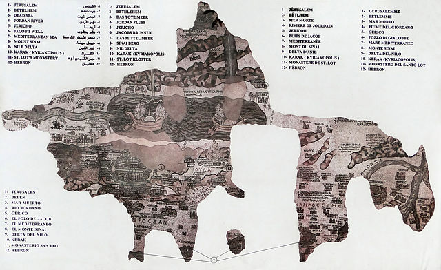
The Madaba Map (also known as the Madaba Mosaic Map) is part of a floor mosaic in the early Byzantine church of Saint George at Madaba, Jordan. The Madaba Map is a map of the Middle East. Part of it contains the oldest surviving original cartographic depiction of the Holy Land and especially Jerusalem. It dates to the 6th century AD.
History
Reproduction of the Madaba Map
The Madaba Mosaic Map depicts Jerusalem with the Nea Church, which was dedicated on the 20th of November, AD 542. Buildings erected in Jerusalem after 570 are absent from the depiction, thus limiting the date range of its creation to the period between 542 and 570. The mosaic was made by unknown artists, probably for the Christian community of Madaba, which was the seat of a bishop at that time. In 614, Madaba was conquered by the Persian empire. In the 8th century AD, the Muslim Umayyad rulers had some figural motifs removed from the mosaic. In 746, Madaba was largely destroyed by an earthquake and subsequently abandoned. The mosaic was rediscovered in 1884, during the construction of a new Greek Orthodox church on the site of its ancient predecessor.[1] In the following decades, large portions of the mosaic map were damaged by fires, activities in the new church and by the effects of moisture. In December 1964, the Volkswagen Foundation gave the Deutscher Verein für die Erforschung Palästinas (“German Society for the exploration of Palestine”) 90,000 DM to save the mosaic. In 1965, the archaeologists Heinz Cüppers and Herbert Donner undertook the restoration and conservation of the remaining parts of the mosaic.
Description
The floor mosaic is located in the apse of the church of Saint George at Madaba. It is not oriented northwards, like modern maps, but faces east towards the altar in such a fashion that the position of places on the map coincides with the actual compass directions. Originally, it measured 21 by 7 m and contained over two million tesserae. Its current dimensions are 16 by 5 m.
Source : wikipedia
https://www.youtube.com/watch?v=ArjXVkS_JuA
https://www.youtube.com/watch?v=_hTFBNjTJGQ
Reviews
Visiting hours : 09.30am to 05.00pm
Entry : Adult JD 1 and Children below 12 years free
Rate this article