Langkawi


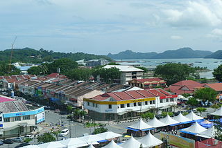
Langkawi, officially known as Langkawi the Jewel of Kedah is an archipelago of 104 islands in the Andaman Sea, some 30 km off the mainland coast of northwestern Malaysia. The islands are a part of the state of Kedah, which is adjacent to the Thai border. By far the largest of the islands is the eponymous Langkawi Island with a population of some 64,792, the only other inhabited island being nearby Tuba Island. Langkawi is also an administrative district with the town of Kuah as largest town. Langkawi is a duty-free island.
Climate
Langkawi receives more than 2,400 mm (94 in) of rain annually. Langkawi has a true dry season from December until February while March to November is a long raining season. September is the wettest month, when it normally receives more than 500 mm (20 in).
Airport
The Langkawi International Airport is one of 7 international airports in Malaysia and connects the island to Kaula Lumpur, Singapore, Penang and also Subang. On the island, a main road runs through the whole island.
Tourism
On 1 June 2007, Langkawi Island was given a World Geopark status by UNESCO. Three of its main conservation areas in Langkawi Geopark are Machincang Cambrian Geoforest Park, Kilim Karst Geoforest Park and Dayang Bunting Marble Geoforest park (Island of the Pregnant Maiden Lake). These three parks are the most popular tourism area within Langkawi Geopark.
Source : Wikipedia
Map of Langkawi
http://www.maps-of-langkawi.com/
Tourist attractions
https://www.youtube.com/watch?v=X076EvJpbNU


Places Of Interest
Beras Basah Island
LangkawiShare this:
Beras Basah Island Pulau Beras Basah, Kedah, Malaysia Phone : +604-966 7789 Langkawi Tourist Information Centre Located at the western tip of Langkawi, Beras Basah Island offers a relaxing getaway with its pristine beaches and lush green forest. Visitors to Beras Basah island usually come as part of a 4- hour island hopping tour, which … Continue reading Beras Basah Island →
Cenang Beach
LangkawiShare this:
Cenang Beach Pantai Cenang Beach is the busiest beach town on Langkawi Island, where you can find a diverse mix of cafes and restaurants, as well as souvenir shops, and duty-free outlets along its picturesque beach strip. Just a 10 minute drive from Langkawi International Airport, it is a popular holiday destination for travelling families … Continue reading Cenang Beach →
Eagle Square
LangkawiShare this:
Eagle Square Kuah Jetty, 07000 Kuah, Malaysia Phone : (604) 966 7789 (Langkawi Tourist Information Centre) Dataran Lang” or ‘Eagle Square’, is the location of a large sculpture in the shape of a sea-eagle perched on rocks in pre-flight pose. This 12-meter high statue greets visitors who come to Pekan Kuah by ferry as they … Continue reading Eagle Square →
Jet Ski Adventure
LangkawiShare this:
Jet Ski Adventure How in the world can you grasp the beauty of all these islands when you only have a few days to visit? An island Jet Ski Tour! Easily the fastest (and most fun!) way to see the islands is to zip around on a jet-ski. There is no other perfect combination! Sun, sea, … Continue reading Jet Ski Adventure →
Langkawi Cable Car
LangkawiShare this:
Langkawi Cable Car The Langkawi Cable Car, also known as Langkawi SkyCab, is one of the major attractions in Langkawi Island, Kedah, Malaysia. It provides an aerial link from the Oriental Village at Telik Burau to the peak of Gunung Machinchang, which is also the location of the Langkawi Sky Bridge. The total length is 2.2 km (1.4 mi), with a journey time from the … Continue reading Langkawi Cable Car →
Langkawi Sky Bridge
LangkawiShare this:
Langkawi Sky Bridge Kedah, Malaysia Phone : +60 4-959 4225 Langkawi Sky Bridge is a 125-metre (410 ft) curved pedestrian cable-stayed bridge in Malaysia, completed in 2005. The bridge deck is located 660 metres (2,170 ft) above sea level at the peak of Gunung Mat Chunchang on Pulau Langkawi, an island in the Langkawi archipelago in Kedah. The Langkawi Sky Bridge can be reached by first taking the Langkawi Cable … Continue reading Langkawi Sky Bridge →
Oriental Village
LangkawiShare this:
Oriental Village Oriental Village, 07000 Langkawi, Kedah, Malaysia Phone : +604 959 3099 The Oriental Village is located in the Burau Bay or north-western quadrant of Langkawi, at the foothills of Mt. Machincang, one of three main areas of interest of Langkawi Geopark. It is owned and managed by LADA Eco-Tourism Sdn Bhd, a fully-owned … Continue reading Oriental Village →
Skytrex Adventures
LangkawiShare this:
Skytrex Adventures Jalan Teluk Yu, Kampung Kok, 07000 Langkawi, Kedah, Malaysia Phone : +60 19-280 5679 Located within the pristine enclosure of Burau Bay, the park tops the ‘must do’ list of all visitors to the magical island of Langkawi. Be enthralled by the dramatic landscape of Gunung Mat Cincang set as the backdrop of … Continue reading Skytrex Adventures →
Sunset Cruise
LangkawiShare this:
Sunset Cruise Langkawi Sunset Cruise is a mid-afternoon daytrip that takes you sailing on the Andaman Sea as you kick back and relax on board a yacht. The upscale adventure starts off at the Awana Porto Malai jetty; once on board, there is an open bar with chilled soda, fruit juice, wine, and beer. The … Continue reading Sunset Cruise →
Taman Legenda
LangkawiShare this:
Taman Legenda Next to Eagle Square and Jetty Point Kuah Jetty, 07000 Kuah, Malaysia Phone : 603 966 4223 Taman Lagenda or Legend Park is a recreational area opened on 27 April 1996 dedicated to Langkawi’s heritage of myths and fables. The park covers an area of 20 hectares of reclaimed land, and is more … Continue reading Taman Legenda →
Tanjung Rhu Beach
LangkawiShare this:
Tanjung Rhu Beach Located about 20 kms. from Kuah town, just beyond Pantai Pasir Hitam, Tanjung Rhu Beach is one of Langkawi’s best shorelines. The waters are as clear as crystal, the sand is powder-fine and you have to drive through dense forests to reach here. The area is absolutely secluded and the atmosphere is … Continue reading Tanjung Rhu Beach →
Telaga Tujuh Waterfalls
LangkawiShare this:
Telaga Tujuh Waterfalls Gunung Mat Cincang in Kuah, Langkawi Telaga Tujuh Waterfalls is considered as Langkawi Island’s most beautiful natural attraction. Its name means Seven Wells Waterfalls, referring to a series of seven connected natural pools fed by seven separate waterfalls in Mount Mat Cincang. At Telaga Tujuh, there are two viewing areas – one … Continue reading Telaga Tujuh Waterfalls →
The Kilim Karst Geoforest Park (The Kilim River) ( Mangrove Tour )
LangkawiShare this:
The Kilim Karst Geoforest Park (The Kilim River) ( Mangrove Tour ) The Kilim Karst Geoforestpark consists of three river estuaries that stretch from the Kisap village approximately 10 km to Tanjung Rhu and they are all interconnected. They are rich in wildlife and tourists may see hairy nosed sea otters, brown winged kingfishers, monitor lizards … Continue reading The Kilim Karst Geoforest Park (The Kilim River) ( Mangrove Tour ) →
The Payar Island Marine Park
LangkawiShare this:
The Payar Island Marine Park Source : youtube.com The Payar Island Marine Park is situated in the northern part of the Straits of Melaka, 19 nautical miles (35 km) south of Langkawi and encompasses the islands of Payar, Lembu, Segantang and Kaca which are surrounded by coral reefs. The marine park teems with a diversity of … Continue reading The Payar Island Marine Park →
Underwater world
LangkawiShare this:
Underwater world Kampung Buku Malaysia, Lubuk Semilang, Kedah, 07000 Langkawi, Malaysia Phone : +60 4-955 6100 Source : youtube Underwater World Langkawi (UWL) the largest aquarium in Malaysia houses a large collection of over 4000aquatic lives. There are more than 500 species of animals and sea creatures in more than 100 specially designed tanks … Continue reading Underwater world →
Wildlife park and Birds Paradise
LangkawiShare this:
Wildlife park and Birds Paradise Lot 1485, Jalan Ayer Hangat, Kampung Belanga Pecah, 07000 Langkawi, Kedah, Malaysia. Phone : +604-9665855, +6010-7789619, Source : youtube.com Langkawi Wild Life Park and Birds Paradise is located in Kilim area, 10 minutes drive from Kuah town is spreaded in 5.5 acres of land. There are about 150 different species … Continue reading Wildlife park and Birds Paradise →