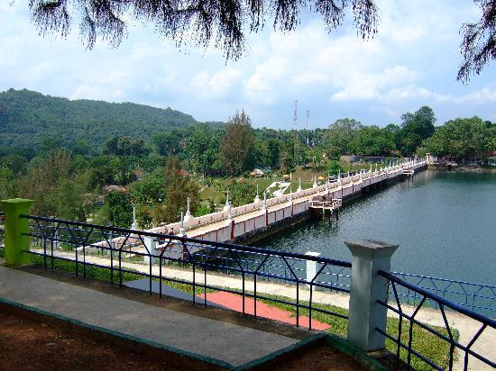
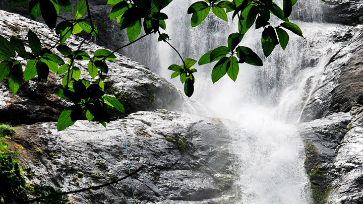
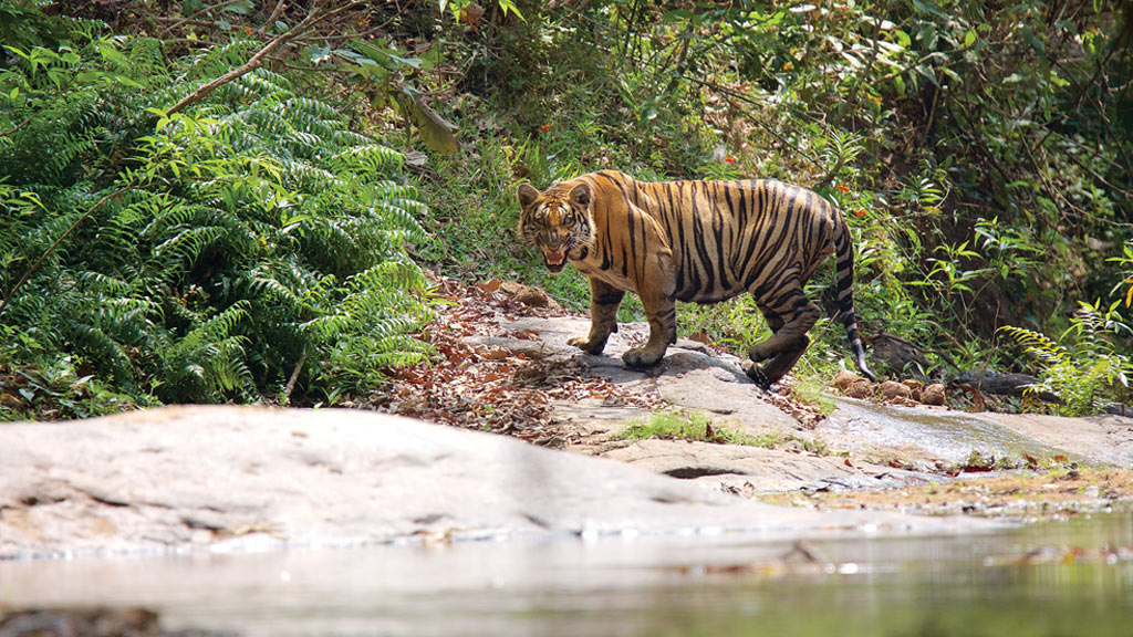
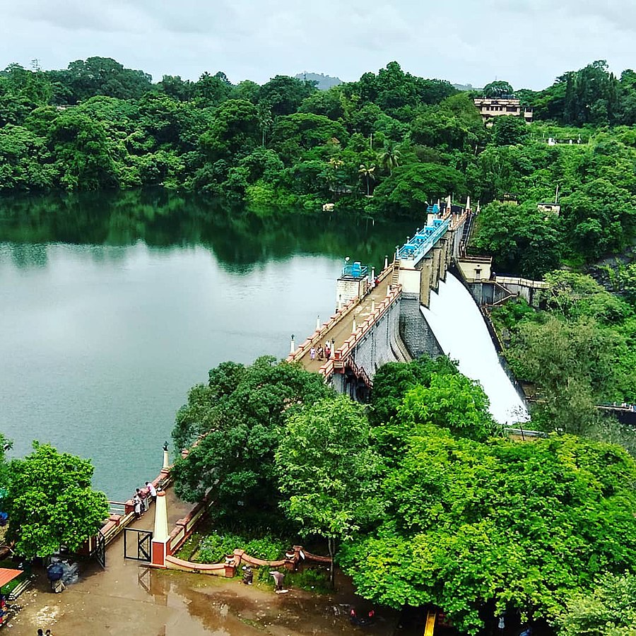
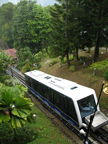
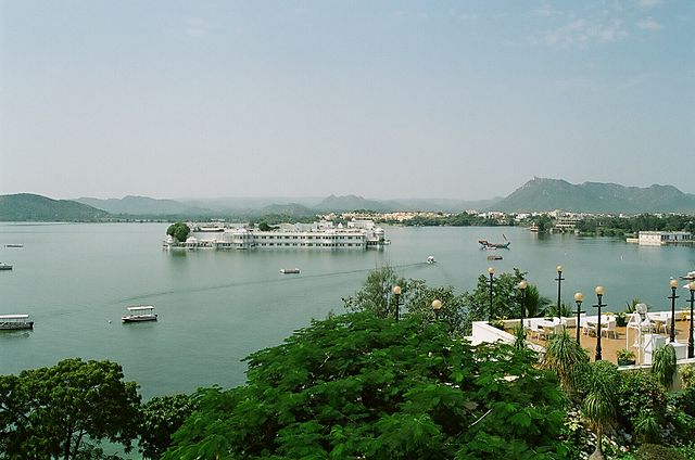
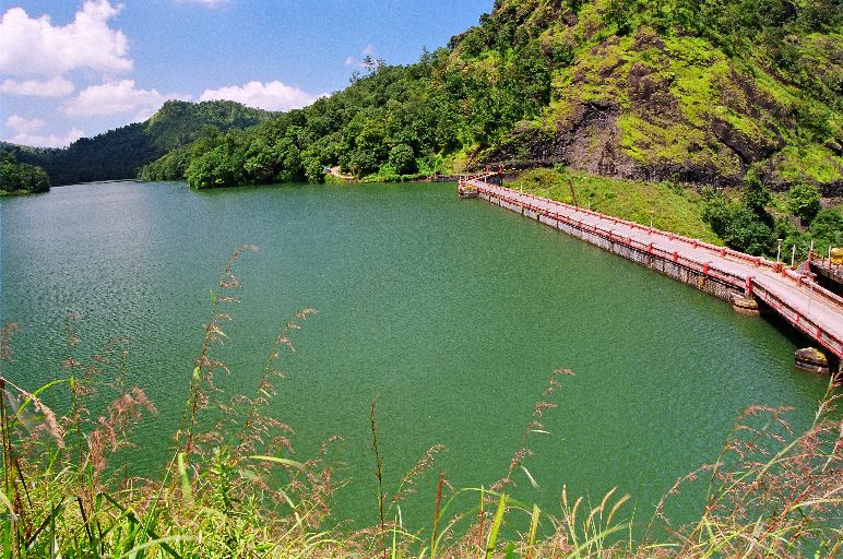
This photo of Neyyar Wild Life Sanctuary is courtesy of TripAdvisor
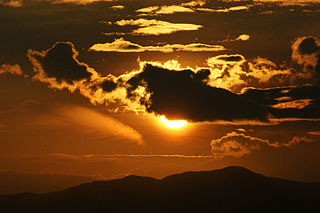
Neyyar dam is a gravity dam on the Neyyar River in Thiruvanathapuram district of Kerala, South India, located on the foot of the Western Ghats about 30 km from Thiruvanathapuram It was established in 1958 and is a popular picnic spot. Lying against the southern low hills of the Western Ghats, Neyyar Dam has a scenic lake.
Image credit : keralatourism.org
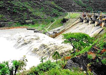
The Neyyar Dam is a Rubble masonry gravity-type dam with a height of 56 m (184 ft) and length of 295 m (968 ft). Its structural volume is 105,000 m3 (3,708,040 cu ft). The dam creates a reservoir of 106,200,000 m3 (86,098 acre·ft) of which 101,000,000 m3 (81,882 acre·ft) is active (useful) capacity. The reservoir’s surface area is 91 km2 (35 sq mi) and the dam’s spillway has a 809.40 m3/s (28,584 cu ft/s) maximum discharge capacity.
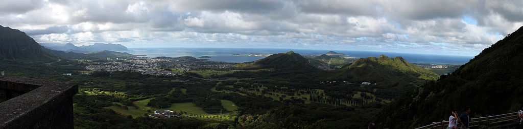
Panorama of Neyyar river
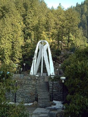
Yoga
Neyyar Dam is home to the beautiful and peaceful Sivananda Yoga Vedanta Dhanwanthari Ashram where you can take courses in Yoga and practice meditation. The trees that are growing inside the Ashram are astonishing by their height and vigor, which is due to both care by the people.Try drinking the juice from a local coconut and eating the white milky lining. On the journey from Trivandrum you will see rubber plantations and the local harvest of the white latex that comes from the trees.
Boating
Tourists can hire a speed boat for Rs 250 per head to view the surrounding forests.
Crocodile Rehabilitation and Research Centre
A crocodile farm was set up in 1977. It also includes a habitat for otters near the administrative complex. The Crocodile Rehabilitation and Research Centre in Neyyar Wildlife Sanctuary was named initially by the Kerala government after the late naturalist Steve Irwin as Steve Irwin National Park.
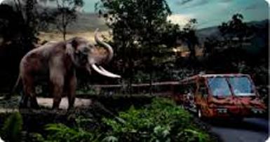
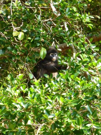
The Neyyar Wildlife Sanctuary of which the dam is a part is the habitat of over a hundred species of fauna including Asian Elephant, Tiger, Leopard, Slender Loris and reptiles like King Cobra, Travancore Tortoise, etc. A crocodile breeding centre and a lion safari park are also located in the dam site.
The Night Safari is the world’s first nocturnal zoo and is one of the most popular tourist attractions in Singapore. Constructed at a cost of S$ 63 million, the Night Safari was officially opened on 26 May 1994 and occupies 35 hectares (86 acres) of secondary rainforest adjacent to the Singapore Zoo and Upper Seletar Reservoir. The Night Safari currently houses over 2,500 animals representing over 130 species, of which 38% are threatened species. The Night Safari is managed by Wildlife Reserves Singapore, and about 1.1 million visitors visit the safari per year. The Night Safari received its 11 millionth visitor on 29 May 2007.
Unlike traditional nocturnal houses, which reverse the day-night cycle of animals so they will be active by day, the Night Safari is an entire open-air zoo set in a humid tropical forest that is only open at night. It is divided into seven geographical zones, which can be explored either on foot via four walking trails, or by tram.
The animals of the Night Safari, ranging from Indian rhinoceros to tarsiers, are made visible by lighting that resembles moonlight. Although it is brighter than full moonlight by a few orders of magnitude, it is dim enough not to disturb nocturnal and crepuscular animals’ behaviour. London based lighting designer Simon Corder created the lighting for Night Safari.
The naturalistic enclosures simulate the animals’ native habitat. Animals are separated from visitors with natural barriers, rather than caged, similar to the Singapore Zoo’s open concept. Instead of vertical prison-like cages, cattle grids were laid all over the park to prevent hoofed animals from moving one habitat to another. These are grille-like metal sheets with gaps wide enough for animals’ legs to go through. Moats were designed to look like streams and rivers to enable fishing cats and servals to be put on show in open areas, and hot wires were designed to look like twigs to keep animals away from the boundaries of their enclosures.
Cultyural performances are a regular feature at the safari, and include tribal dances, blowpipe demonstrations and fire eating displays. Creatures of the Night Show is a performance presented by the animals in the Night Safari.
Food and beverage outlets in the Night Safari include Ulu Ulu Safari Restaurant, Bongo Burgers, and Casa Italia. Visitors can also experience dining on the move with the Cocktail Safari Express and Gourmet Safari Express.
Niranam Pally as Niranam Valiya Pally or St. Mary’s Orthodox Syrian Church, Niranam, a church under the Niranam Diocese of the Indian Orthodox Church.is one of the oldest churches in Kerala. It is believed that the church was founded by St.Thomas, one of the twelve Apostles of Jesus Christ, in AD 54. The church was reconstructed several times since then. The stones in the church shows the reconstruction in 1259.
Niranam Pally witnessed a number of historical events in the Malankara Orthodox Church history including the establishment of a Catholicate in India. The first Catholicose and second Catholicose of the church were ordained at Niranam Church (in 1912 and 1925). Four of the Malankara Metropolitans of the Church died while staying here and two were buried here.
The tall granite cross at the right side of the entrance is a relic of the past, probably from 1259, the time at which the third renovation of the church building took place. The base of the cross has carvings resembling Hindu Temples.
Niranam Church celebrate the feasts of Saint Mary in whose name the church is dedicated, the feast of Saint Thomas who is the founder of Malankara Orthodox Syrian Church and the Apostle of India and the feasts of Mar Thoma II and Mar Thoma V whose mortal remains are buried in the church.
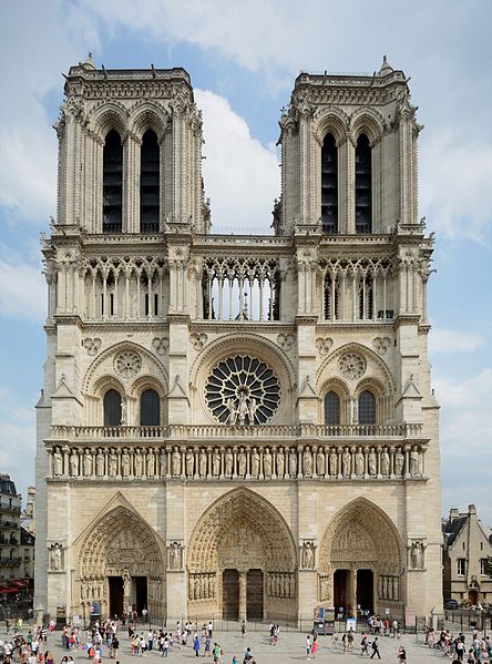
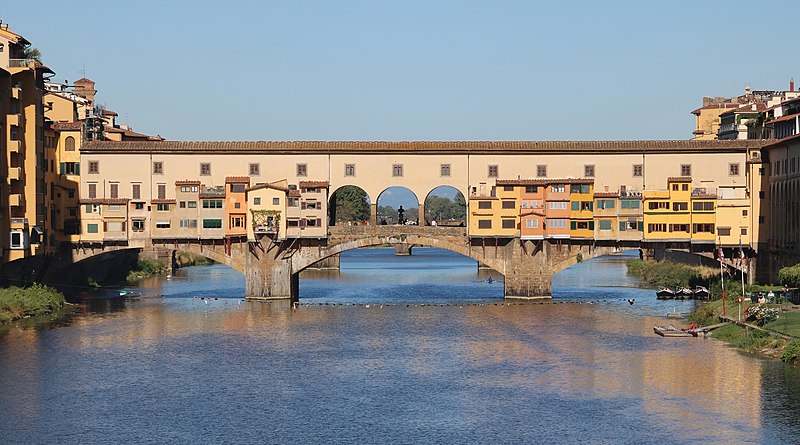
6 Parvis Notre-Dame – Pl. Jean-Paul II, 75004 Paris, France Phone +33 1 42 34 56 10
Image Credit : wikipedia
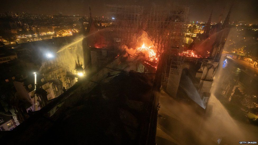
Notre-Dame de Paris, also known as Notre-Dame Cathedral or simply Notre-Dame, is a medieval Catholic cathedral on the Île de la Cité in the fourth arrondissement of Paris, France. The cathedral is widely considered to be one of the finest examples of French Gothic architecture. The innovative use of the rib vault and flying buttress, the enormous and colorful rose windows, and the naturalism and abundance of its sculptural decoration all set it apart from earlier Romanesque architecture.
The cathedral was begun in 1160 and largely completed by 1260, though it was modified frequently in the following centuries. In the 1790s, Notre-Dame suffered desecration during the French Revolution when much of its religious imagery was damaged or destroyed. Soon after the publication of Victor Hugo’s novel The Hunchback of Notre Dame in 1831, popular interest in the building revived. A major restoration project supervised by Eugène Viollet-le-Duc began in 1845 and continued for twenty-five years. Beginning in 1963, the facade of the Cathedral was cleaned of centuries of soot and grime, returning it to its original color. Another campaign of cleaning and restoration was carried out from 1991-2000.
As the cathedral of the Archdiocese of Paris, Notre-Dame contains the cathedra of the Archbishop of Paris, currently Michel Aupetit. 12 million people visit Notre-Dame yearly, which makes it the most visited monument in Paris.
The Cathedral Notre Dame is one the top attractions in Paris and probably the most well known Roman Catholic cathedral in the entire world, thanks to Victor Hugo’s novel The Hunchback of Notre Dame. The cathedral is located on the eastern half of the Ile la Cite along the Seine, in the fourth arrondissement. The cathedral is a fine example of Gothic architecture and has a reputation for being one of the most impressive churches worldwide, with its sculptures and stained glass.
GET TO KNOW THE NOTRE DAME CATHEDRAL IN PARIS
The Bishop of Paris Maurice de Sully ordered the old cathedral to be demolished in 1160 and construction of the new cathedral, the Notre Dame, was completed in 1345. During the French Revolution, the Cathedral suffered major damages, especially to its religious imagery, but was restored later by Eugene Viollet le Duc starting in 1845. And more recently, in 1991, more restorations took place.
The details of the Notre Dame cathedral worth checking out aren’t all above ground though… beneath the cathedral is an archaeological crypt, which was built in 1965 in order to protect historical relics dating back to the earliest settlements in Paris, and were discovered during construction. One of the major factors in the cathedral is the organ. Several of them have been installed over time but the first ones were not suitable. The first organ that was noteworthy was installed in the 18th century and was built by Francois Henri Clicquot. In the 19th century the organ was nearly completely rebuilt, consisting of 7,374 pipes, but some of the original pipes can still be heard. Due to its overwhelming popularity it’s best to visit Notre Dame during the week when lines to visit the top are shorter. Be sure to check out the crypts of Cathedral Notre Dame which is an often forgotten treasure of this beautiful building!
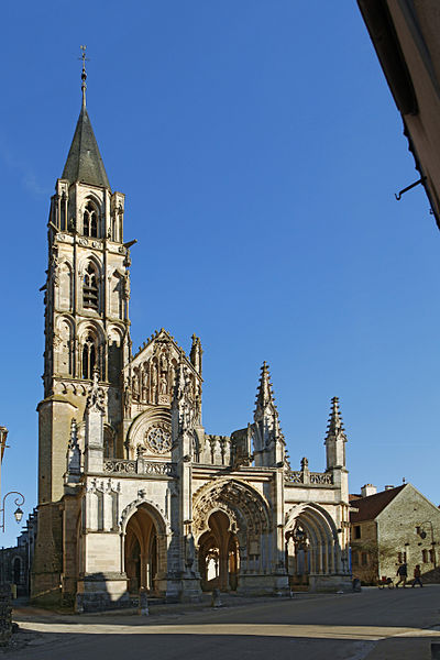
A true gem of Burgundian Gothic art, the Church of Saint-Père deserves the greatest attention.
Built from the 13th to the 15th century. and dedicated to the Virgin, it became a parish church in the sixteenth century, succeeding the old church of St. Peter (which we can still see the ruins at the southern exit of the village) which gave its name to the village .
The bell tower, of the thirteenth century, elegant and airy, more than fifty meters high, presents at the four corners of the tower, angels ringing the olifant to call all the men before the Sovereign Judge.
Under the porch one can see, carved in the round, a woman accompanied by a man holding a model church and specialists admit this couple as the founders. This man and this woman, although very fortunate, were not noble and after their disappearance, the church could not enjoy any income, as the curious inscription of the central trilobe portal specifies. The porch is also home to a beautiful woman’s tomb dated 1258. This is the only item dated from the church.
At the great pinnacle dominating the narthex, Christ sits on a throne, surrounded by saints and according to the meticulous description of Father Pissier, erudite archaeologist and former pastor of the village, the grand facade of the church and the porch is like an immense representation of the last judgment, which testifies to the essentially funerary character of this church.
The interior of the monument, very bare, has a luminous nave of great purity, completed by five radiant chapels. In the entrance we can see two cast iron font of the fourteenth century and, along the collateral, the tombs of the supposed founders of which one of the recumbent, unfortunately mutilated, is still in place.
Source : tourisme-yonne.com https://www.youtube.com/watch?v=XC_MX1HybF4 Reviews https://bit.ly/2ROYcdi Opening hours : Guided tours: all year long, from 9 am to 12 pm and from 1 pm to 6:30 pm Suggested duration : 1 hour
Nuʻuanu Pali is a section of the windward cliff of the Koʻolau mountain located at the head of Nuʻuanu Valley on the island of Oʻahu. It has a panoramic view of the windward (northeast) coast of Oʻahu. The Pali Highway (Hawaii State Highway 61) connecting Kailua/Kāneʻohe with downtown Honolulu runs through the Nuʻuanu Pali Tunnels bored into the cliffside.
The area is also the location of the Nuʻuanu Freshwater Fish Refuge and the Nuʻuanu Reservoir in the jurisdiction of the Hawaiʻi Department of Land and Natural Resources.
The Nuuanu Pali State Wayside is a lookout above the tunnels where there is a panoramic view of the Oʻahu’s windward side with views of Kāneʻohe, Kāneʻohe Bay, and Kailua. It is also well known for strong trade winds that blow through the pass (now bypassed by the Nuʻuanu Pali Tunnels). The The Tunnels were built in 1958. Before this road opened, people would use the what is now known as the Old Pali Road. The Old Pali Route is now a popular hiking route
Source : wikipedia https://www.youtube.com/watch?v=6iUt-F0xSzI Reviews https://bit.ly/2zN5w4n
Click On The URL Or PICTURE for the complete News, Videos and more photos.
A nursery worker was caught on CCTV slapping and kicking a baby so hard the tot suffered a fractured skull and internal bleeding.
Afsana Shaikh was filmed beating nine-month-old Ritisha Sinha during nap time at the day care centre in western India.
The shocking attack took place on the infant’s first day at the nursery, in the city of Kharghar, in Maharashtra State.
Ritisha’s mother, Ruchita, noticed a bruise on the little girl’s face when she collected her.
Dad Rajat said: “Ritisha was fast asleep but there was a bruise under her eye. When my wife asked about it, the centre owner said she had hit herself while playing.
“Initially, we thought that Ritisha may have been stressed because it was her first day, and we believed the caretaker.
“But at home, she was crying continuously and refused to eat anything.”
Rajat, 31, and Ruchita, 29, discovered more bruises on their daughter’s back and behind her ear.
Rishita also developed a fever and started vomiting.
The worried parents took her to a doctor the next day and a hospital CT scan later revealed that she had suffered a small fracture at the back of her skull, which had led to internal bleeding.
Medics at the nearby Fortis Hospital told the couple that Rishita’s injuries were most likely the result of an assault.
The horrified parents returned to the day care centre and demanded to see CCTV footage but were reportedly told by the nursery owner, Priyanka Nikam, that they must first file a police complaint.
Kharghar police officers were notified and checked the CCTV footage before arresting both the carer and the owner.
Mum Ruchita said: “We could not believe our eyes while watching the CCTV footage.”
Dad Rajat added: “It was inhuman. The carer was manhandling my daughter – hitting her with toys and throwing her on the mat.
“We just saw what she did to my baby, who knows how she is treating the other kids at the centre.”
According to reports, the owner has been released on bail while the carer remains in custody facing charges over the incident.
The Oachira Temple is an extremely ancient temple located in Oachira in Kollam district in the South Indian state of Kerala. According to the Puranas, this temple is one of the famous sacred places of Kerala and India. Oachira is on the border of Kollam and Alappuzha districts, next to the National Highway 47. This very ancient pilgrimage center is centered on the Parabrahma temple (that is dedicated to the Para Brahmam (or Param Brahman) or Ohmkaram, the Universal Consciousness), and covers thirty-six acres of land.
Every year the Oachira Vrischikam Festival is celebrated during December and January. Oachirakkali is a famous ritual performed here during June and it involves mock-fighting in muddy water by traditional martial art experts. And “Irupathattam onam” (28 days after Onam) is also celebrated. It is the festival of cattle. In this festival, huge “Eduppu kala” (gigantic idols of bull madeof cloth&hay) are made. They are then pulled on giant wheels to the Oachira Temple from the site where they are made. Normally there are around 50 such structures. It is the biggest festival in “Onattu Kara” which is an area of a few square miles. Oachirakkali was actually a war exercise performed annually by soldiers of Kayamkulam Raja. Nearby, about 108 Kalaries were in 52 karas up to the beginning of 20th century. Soldiers belonging to the above Karas met together at Oachira in the Malayalam month of Mithuna every year and performed war-like exercises. This is what is called Oachirakkali. During the years of the Kayamkulam Rajah, Oachirakkali was started after the blessings of nearby Nambiathiris, high order Nambudiri Brahmins, having the knowledge of Dhanurveda (the science of arms) who were also experts in Smrithy Sasthras.
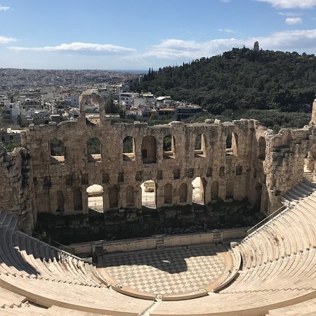
(Located on the southwest slope of the Acropolis)
The Odeon of Herodes Atticus is a stone Roman theatre structure located on the southwest slope of the Acropolis of Athens, Greece. The building was completed in AD 161 and then renovated in 1950.
Ancient times
It was built in AD 161 by the Roman citizen Herodes Atticus in memory of his Roman wife, Aspasia Annia Regilla. It was originally a steep-sloped theatre with a three-story stone front wall and a wooden roof made of expensive cedar of Lebanon timber. It was used as a venue for music concerts with a capacity of 5,000. It lasted intact until it was destroyed and left in ruins by the Heruli in AD 267.
Modern events
The audience stands and the orchestra (stage) were restored using Pentelic marble in the 1950s. Since then it has been the main venue of the Athens Festival, which runs from May through October each year, featuring a variety of acclaimed Greek as well as International performances.
Source : Wikipedia https://www.youtube.com/watch?v=mzp3Ka4Yn-4 https://www.youtube.com/watch?v=Gav6zpE7nls Reviews https://bit.ly/3LqNbdV Opening hours : 08 AM to 08.00PM Entry : A normal entry pass to just sightsee will cost 20 Euros (1598 INR) or a reduced 10 Euros (799 INR). One can also buy the Acropolis special ticket for 30 Euros (2397 INR)
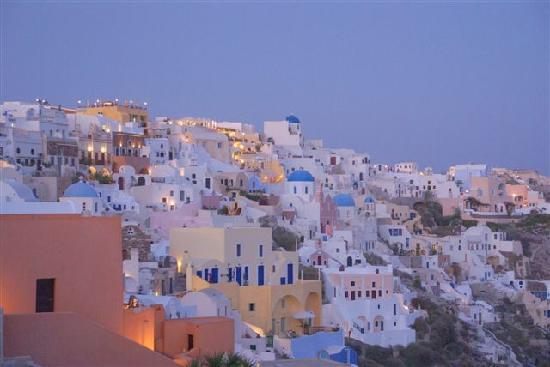
Oia is a small village and former community in the South Aegean on the islands of Thira (Santorini) and Therasia, in the Cyclades, Greece. Since the 2011 local government reform it has been part of the municipality of Santorini, of which it is a municipal unit. It covers the whole island of Therasia and the northwesternmost part of Santorini, which it shares with the municipal unit of Santorini. The main street is named Nikolaou Nomikou.
Oia was previously known as Apano Meria (“upper side”), a name which still occurs locally as Pano Meria and the inhabitants are still called Apanomerites . The Ancient Greek Oia was one of the two harbours of ancient Thera and was located in the southeast of the island, where Kamari is now.
Source : Wikipedia https://www.youtube.com/watch?v=jxDt16dXLRk https://www.youtube.com/watch?v=_2kpOruxKNA
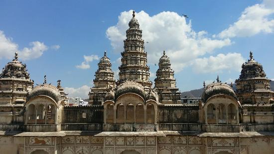
Old Rangji Temple is one of the most popular temples among tourists. Built 150 years back, having a blend of Mughal and Rajput architecture, the visit to the temple will be a memorable experience. The high-rising Gopuram also reflects South Indian architectire, and adds more charm to the temple. The temple is dedicated to Lord Rangji, an incarnation of Lord Vishnu. In 1823, the temple was built by Seth Puran Mal Ganeriwal. The temple houses an image of Garuda, Lord Vishnu’s mount and is considered one of the holiest temples of Pushkar.
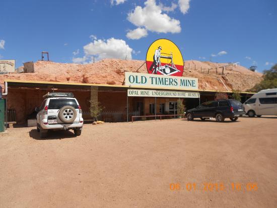
2190 Crowders Gully Road,
Coober Pedy,
South Australia 5723 Australia
+61 8 8672 5555
Image Credit : tripadvisor.in
Explore how miners lived and worked during the opal mining times in early 1900s. As you walk through the cave and tunnels at Old Timers Mine, you will see old pick marks and even streaks of opal that have been left in the rocks. You can visit an underground house used by the miners that now displays a collection of opals and various artifacts from the mine’s history. Outside, try your hand at the old manufacturing process with an interactive session using a pipe to filter the stones. The gift shop features polished opals and jewelry. Plan to visit Old Timers Mine during your Coober Pedy vacation using our convenient.
Source : inspirock.com https://www.youtube.com/watch?v=uTxnBhVLhf4
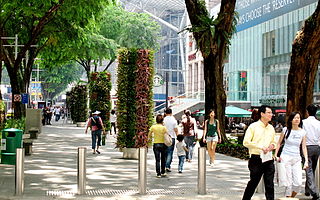
Orchard Road, a 2.2 kilometre-long boulevard, is the retail and entertainment hub of Singapore. Often known colloquially as Orchard, the area is a major tourist attraction. It is also known as Tang Leng Pa Sat Koi (Tanglin Market Street) and Vaira Kimadam (Fakir’s Place) by the Singaporean Chinese and Singaporean Tamils respectively.
The Orchard Planning Area a planning area as specified by the Urban Redevelopment Authority. It is part of the Central Area located within the Central Region. Orchard is bordered by Newton in the east and north, Tanglin in the west, River Valley in the south and Museum to the southeast.
The Road underwent a $40 million revamp in 2009, with the addition of new street lamps, planter boxes, urban green rooms, street tiling and flower totem poles, which have since been removed.
Orchard Road got its name from the nutmeg, pepper and fruit orchards or the plantations that the road once led to. Such plantations were common in the area in the 19th century. Other sources attribute the name to Mr Orchard, a gardener and the owner of plantations which were located at the corner of present-day Scotts Road and Orchard Road.
The first shop of note on Orchard Road was Tangs founded in 1934 and established on Orchard Road in the 1950s.
The Road is flanked by pedestrian shopping centres. Orchard Road contains numerous upmarket restaurants, coffee chains, cafés, nightclubs and hotels. It is the site of the official residence and office of the President of Singapore, the Istana.
Tanglin Mall is located at the junction of Tanglin Road and Grange Road. Its customer base is made up of expatriates, yuppies and professionals. Anchor tenants include Tanglin Market Place, a gourmet supermarket and bakery, and Tasty Food Court where up to 15 varieties of local cuisine can be found.
Orchard Central distinguishes itself from other shopping centres on Orchard Road with architectural and design forms. Fronted by an exterior featuring local artist Matthew Ngui’s digital art membrane, the shopping centre offers cluster concept shopping by grouping complementary offerings for shoppers. The shopping centre houses the world’s tallest indoor Via Ferrata climbing wall, a large collection of public art installations by international artists and a 24/7-operational Roof Garden and Discovery Walk. The Roof Garden offers dining options on an open-air veranda.
Source : wikipedia
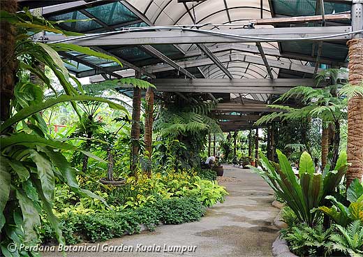
Jalan Tembusu, 50480 Kuala Lumpur, Wilayah Persekutuan Kuala Lumpur, Malaysia
The orchid park is close to the bird park and the butterfly park and is worth spending an hour just looking around at the different colour blooms and displays. The Orchid Park houses up to 800 species of orchids. The garden comprises a semi circle pergola for the climbing and epiphytic variety and a rock garden for the terrestrial variety.
Just a stone throw away is the Kuala Lumpur Hibiscus Garden where you will be able to see the many colours of hibiscus being grown here. Hibiscus is the National Flower (Hibiscus Rosa-Sinensis) of Malaysia and this garden was created in the year 1989 with an area of 0.9 hectares. There are over 5,000 species that are planted here. The Hibiscus Park showcases the various species of Malaysia’s national flower, the Bunga Raya (Hibiscus Rosa Sinensis). Some of the attractions in the garden include a 4-metre high waterfall, pools and fountains. A lovely colonial style building has been converted into an exhibition hall with a tearoom and a gallery.
Admission : The admission fee is FREE during the Weekday but a nominal fee of RM1 is charged for each garden during the Weekend.
Getting there : Bus 21C or 48C from behind Kotaraya Plaza runs a route past the KL Bird Park (which is right opposite the Orchid & Hibiscus Gardens). If you are coming from Chow Kit, you can hop on bus 18 or 21A and get off at the old railway station: the gardens are a short walk away from here.
To get back to the city walk to the KL Bird Park: there are usually plenty of taxis waiting here. If you do not want to walk to the Bird Park, then it may be worth chartering a taxi or booking one ahead of time.
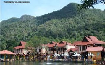
The Oriental Village is located in the Burau Bay or north-western quadrant of Langkawi, at the foothills of Mt. Machincang, one of three main areas of interest of Langkawi Geopark. It is owned and managed by LADA Eco-Tourism Sdn Bhd, a fully-owned subsidiary of the Langkawi Development Authority (LADA).
The Village may be synonymous with “Langkawi Cable Car,” but the Village truly has more to offer visitors than just cable car rides. In fact, the Village offers more than 50 activity providers; food & beverage outlets; souvenir & retail stores; galleries; hotels and spas, making it the largest outdoor lifestyle mall in the northern region.
One should set aside a good day aside to enjoy the activities, shopping and gastronomic delights the Village has to offer.
Cable Car Rides & Elephant Rides
The primary attraction of the Village is Langkawi Cable Car. However, aside for this exciting ride into Mt. Machincang, the Village also offers elephant rides, ATV trails, motor-cross rides and SEGWAY tours in and around the Village.
With more than a dozen food & beverage outlets at the Oriental Village, hungry visitors will not be disappointed as F&B outlets at the Village offer a diverse range of cuisine, especially the Malaysian or Oriental types. Western menus are also available here.
Shopping
There are moer than 20 souvenir and retail outlets and kiosks around the Village, offering some of the best value-for-money souvenir shopping on the island.
The largest retail or souvenirs stores at the Oriental Village are the Zon Duty-free Emporium and Langkawi Shopping Zone.
Galleries
The Village features several galleries of interest including the Langkawi Geopark Information Center, the National University of Malaysia (UKM) Reseach Exhibition and the Tiger! Tiger! Gallery & Exhibit that features a “live” tiger exhibit.
Click On The URL Or PICTURE for the complete News, Videos and more photos.
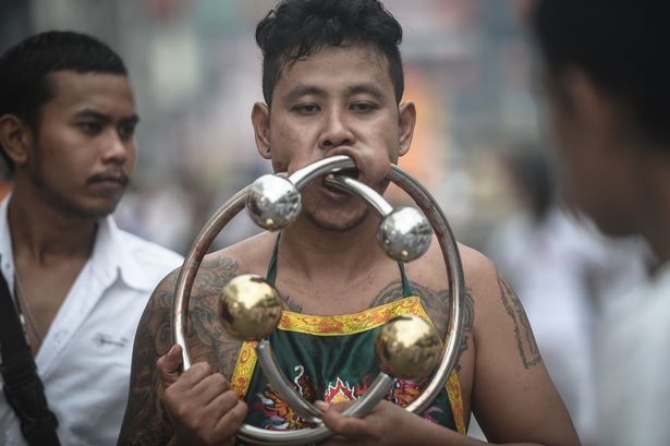
Swords, skewers and needles inserted in flesh are standard sights at the annual Phuket Vegetation Festival .
The event offers an extreme showcase of those who show religious devotion through ritualistic self-mutilation and pain trials.
When participants aren’t putting kebab skewers through their cheeks, some are running over hot coals just to show how authentic their faith is.
The Phuket Vegetation Festival is an annual event held during the ninth lunar month of the Chinese calendar.
It is believed that the vegetarian festival and its accompanying sacred rituals for the Nine Emperor Gods bestow good fortune upon those who religiously observe this rite.
Residents of Chinese ancestry strictly observe a 10-day vegetarian or vegan diet for the purposes of spiritual cleansing, and sacred rituals are performed at various Chinese shrines and temples.
As well as walking barefoot over hot coals, some attendees ascend ladders with bladed rungs.
The devotees, names ‘Ma Song’, or entranced horses, believe that gods enter them during the fest.
They manifest supernatural powers and perform self-tortures in order to shift evil from individuals onto themselves, and to bring the community good luck.
Throughout the festival fireworks and drums are sounded – the louder the better, because the noise drives away evil spirits.
Canadian tourist Barry Rafftery told AFP: “It’s an unforgettable experience,” adding: “I’m surprised by the lack of blood.”
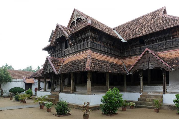
The Palace is located 16 kms. from Nagercoil and 52 kms. from Trivandrum.
A magnificent wooden palace of the 16th century, Padmanabhapuram Palace lies at the land’s end of mainland India – Kanyakumari. An enticing ediffice to any lover of art and architecture this old palace of the Rajas of the erstwhile Travancore (1550 to 1750 AD) is a fine specimen of Kerala’s indigenous style of architecture. The antique interiors are replete with intricate rosewood carvings and sculptured decor. The palace also contains 17th and 18th century murals. One can see: the musical bow in mahogany, windows with coloured mica, royal chairs with Chinese carvings, ‘Thaikkottaram’ or the Queen Mother’s palace with painted ceilings, rose wood and teak carved ceilings with 90 different floral designs.
Durbar Hall of the palace has a shiny black floor specially made from a combination of egg white, jaggery lime, burnt coconut, charcoal and river sand, granite tubs to cool curd and buttermilk, secret underground passages, the King’s bedroom with a four poster medicinal bed, mural paintings, pictures of Lord Krishna, hanging brass lanterns lit continuously since the 18th century, open air swimming bath, granite dance hall, Saraswathi (goddess of knowledge) temple, large earthen urns, room for scribes and accountants, carved figures on columns holding oil lamps, pooja (worship) rooms with jackfruit tree columns, fish carvings on the ceilings, enormous teak beams, Belgian mirrors and an outer cyclopean stone wall fitted together without mortar.
Visitors to the palace are often overwhelmed by the royal splendour of erstwhile Travancore. Though the palace is situated in Kanyakumari district of Tamilnadu State, it comes under the Government of Kerala’s administration.
Painted Desert Rd, Oodnadatta SA 5734, Australia
Phone : +61 8 8670 7992
Image Credit : Tripadvisor
The Painted Desert is in the Far North of South Australia. It is 120 kilometres (75 mi) north-east of Coober Pedy, in the Arckaringa Station pastoral lease, not far from the homestead. It is notable for its distinctive mesas, mountains, and geological formations. Not far from here on the way to Oodnadatta, there are large areas of ground covered with mica. The entire region is desolate and made up of soft, fragile rock.
The Painted Desert was seabed 80 million years ago. As the land rose, some of the rock has eroded away, leaving the Arckaringa Hills in many shades of orange, yellow, and white shale on the slopes. The Mirackina Range of mesas extends to the west.
The Arckaringa Hills is of geological and biological significance as it is also the site of rare plant species and the southernmost extent of the range of Australia’s largest monitor lizard.
Source : wikipedia https://www.youtube.com/watch?v=COoN-6r2WhM https://www.youtube.com/watch?v=-W4b1ZS-YtM https://www.youtube.com/watch?v=dAZONw4Lh7A Reviews : https://bit.ly/39vwvxF Open : 24 hours
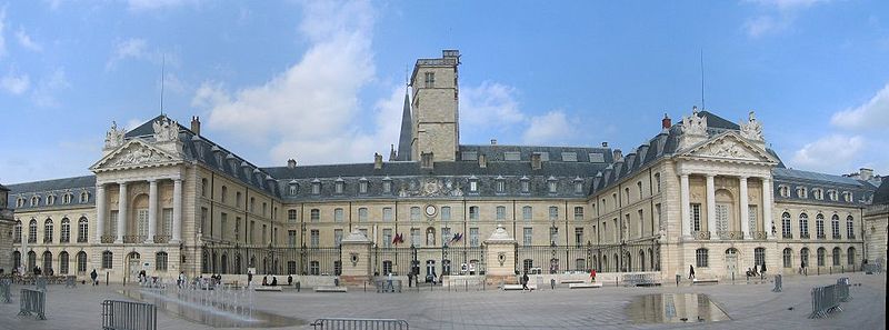
1 Place de la Libération, 21000 Dijon, France Phone : +33 3 80 74 52 09
Image Credit : wikipedia
The Palace of the Dukes and Estates of Burgundy or Palais des ducs et des États de Bourgogne is a remarkably well-preserved architectural assemblage in Dijon. The oldest part is the 14th and 15th century Gothic ducal palace and seat of the Dukes of Burgundy, made up of a logis still visible on place de la Liberation, the ducal kitchens on cour de Bar, the tour de Philippe le Bon, a “guette” overlooking the whole city, and tour de Bar. Most of what can be seen today, however, was built in the 17th and especially the 18th centuries, in a classical style, when the palace was a royal residence building and housed the estates of Burgundy. Finally, the 19th façade of the musée on place de la Sainte-Chapelle was added on the site of the palace’s Sainte-Chapelle, demolished in 1802. The Palace houses the city’s town hall and the musée des Beaux-Arts.
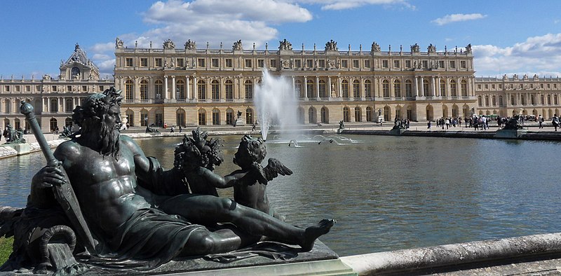
Place d’Armes, 78000 Versailles, France Ph. +33 1 30 83 78 00
Image credit : wikipedia Attribution : G CHP
The Palace of Versailles was the principal royal residence of France from 1682 under Louis XIV until the start of the French Revolution in 1789 under Louis XVI. It is located in the department of Yvelines, in the region of Île-de-France, about 20 kilometres (12 miles) southwest of the centre of Paris.
The palace is now a Monument historique and UNESCO World Heritage site, notable especially for the ceremonial Hall of Mirrors, the jewel-like Royal Opera, and the royal apartments; for the more intimate royal residences, the Grand Trianon and Petit Trianon located within the park; the small rustic Hameau (Hamlet) created for Marie Antoinette; and the vast Gardens of Versailles with fountains, canals, and geometric flower beds and groves, laid out by André le Nôtre. The Palace was stripped of all its furnishings after the French Revolution, but many pieces have been returned and many of the palace rooms have been restored.
In 2017 the Palace of Versailles received 7,700,000 visitors, making it the second-most visited monument in the Île-de-France region, just behind the Louvre and ahead of the Eiffel Tower.
Planning to visit Paris? There are many things to do in and around Paris. One very popular attraction is only 30 minutes away of the city – make sure not to miss Versailles Palace! Chateau Versailles is one of the most extravagant palaces in the world and has been a source of great inspiration for many other palaces. Although the town of Versailles isn’t actually in Paris, it is well worth the visit to this extraordinary place.
GET TO KNOW MORE ABOUT THE VERSAILLES PALACE IN PARIS
The first mention of the town was in the beginning of the 11th century in a charter of the Abbey of Saint-Père de Chartres. The town was prosperous until the 13th century, although after the 100 year war only a handful of people remained.
In the 16th century, King Louis XIII visited the town and liked the place so much he decided to purchase land, which gave much acclaim to the village. In 1632, King Louis became the Lord of the Versailles and began enlarging his Lodge. The Gondi family, who were the rulers of Versailles at the time were bought out by Louis who was to finish his career in 1643. When King Louis XIV, otherwise known as the Sun King, became King, he took an interest in Versailles and due to his distrust of the Parisians, decided to move his residence from the political turbulence of the Louvre to now standing Palace. It was during the French Revolution that most of the paintings, antiques and other works of art were moved to the Louvre, the National Library and the Conservatory of Arts and Crafts. Most of the furniture apparently was sold at auctions.
We highly recommend a visit to the Versailles Palace! But take into consideration that it’s a big place, outside of Paris, and there’s a lot to see, so a trip to Versailles might take up at least half a day, possibly a day. When you already took the trouble of leaving Paris and traveling to the palace, you want to see everything, right? The palace itself, but also the magnificent gardens!
For more information about Paris sightseeing and attractions, check out our video guides.
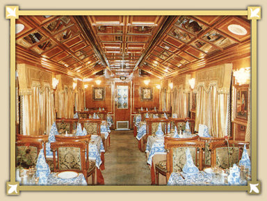
The Palace on Wheels is a luxury tourist train. It was launched by the Indian Railways in association with Rajasthan Tourism Development Corporation to promote tourism in Rajasthan.
The concept of the Palace on Wheels was derived from the royal background of the coaches, which were originally meant to be the personal railway coaches of the erstwhile rulers of the princely states of Rajputana, Gujarat, the Nizam of Hyderabad and the Viceroy of British India.
Each saloon highlights the cultural ethos of the state, represented through the use of furniture, handicrafts, painting and furnishings. Delhi-based interior designer Monica Khanna did the interiors of the train.
There are 23 coaches in the train. 104 tourists can travel in train. Each coach is named after former Rajput States and matches the aesthetics and interiors of the royal past: Alwar, Bharatpur, Bikaner, Bundi,Dholpur, Dungarhgarh, Jaisalmer, Jaipur, Jhalawar, Jodhpur, Kishangarh, Kota, Sirohi and Udaipur. Each coach has four cabins (named chambers or saloons by the company) with luxury amenities and Wi-Fi internet.
The train has two restaurants, The Maharaja and The Maharani with a Rajasthani ambiance serving continental, Chinese cuisine, one bar cum lounge, 14 saloons and a spa.
The train has a 7 nights & 8 days itinerary, departs from New Delhi (Day 1), and covers Jaipur (Day 2), Sawai Madhopur and chittaurgarh (Day 3), Udaipur (Day 4), Jaisalmer (Day 5), Jodhpur (Day 6), Bharatpur and Agra (Day 7), return to New Delhi (Day 8).
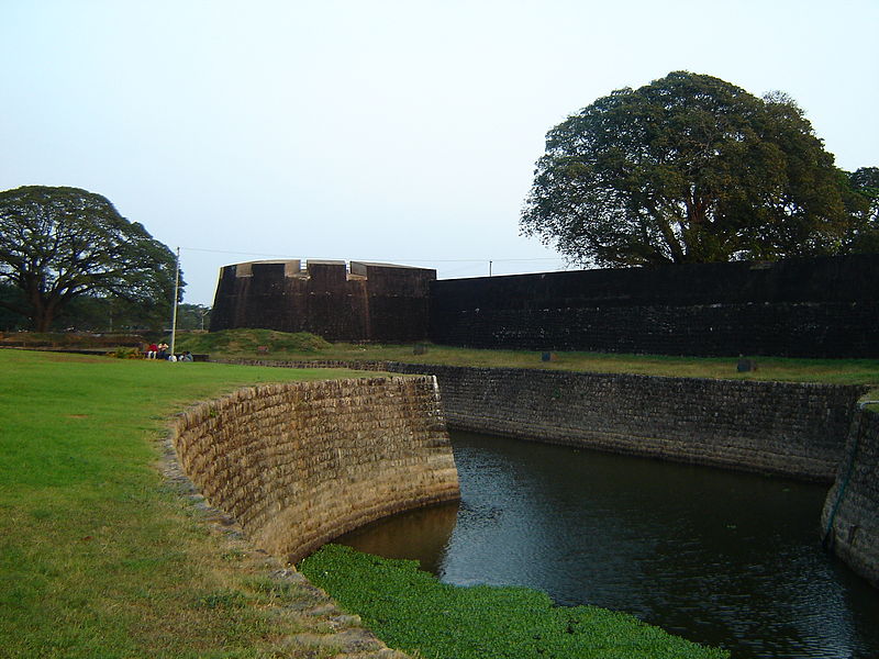
Palakkad Fort is an old fort situated in the heart of Palakkad town of Kerala state, southern India. It was recaptured and rebuilt grandly by Sultan Hyder Ali in 1766 A.D and remains one of the best-preserved forts in Kerala.
There is a large ground between the Fort and the Palakkad Townhall, known as Kota Maidanam (Fort Maidan/Fort Grounds). The ground is now used to stage cricket matches, exhibitions, and public meetings. An open-air auditorium called “Rappadi”, currently under the preservation of the Archeological Survey of India, is also located within the spacious grounds of the Fort. Additionally, there is a children’s park on one side of the Fort.This children’s park is known by the name “Vatika” , which has a beautiful garden alongside outdoor playground equipments for kids.
The Palakkad Special Sub Jail is also located within the fort. There is a small shrine dedicated to Lord Hanuman known as Anjaneya Swamy temple, The temple is situated on the Eastern entrance of the fort, Figure Anjaneya is carved on the inner side of the fort wall. The murti of Lord Anjaneya is south facing, while the lord himself is facing west. It is believed that Tipu and his warriors worshipped the lord to protect them from all enemies. A garden called Vatika-Shilavatika is maintained inside the court.
Source : wikipedia https://www.youtube.com/watch?v=2drrFulJ4lw https://www.youtube.com/watch?v=_Shc6hnoWTM Reviews https://bit.ly/3nF8GhO Timings : 08.00AM to 06.00PM Entry : Free
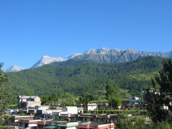
Palampur is a green hill station and a municipal council in the Kangra valley in the Indian State of Himachal Pradesh, surrounded by tea gardens and pine forests before they merge with the Dhauladhar ranges. Palampur is the tea capital of northwest India but tea is just one aspect that makes it a special interest place. Abundance of water and proximity to the mountains has endowed it with mild climate. Palampur is hometown of cap.vikram batra (the real lion of India) Paramvir chakr (The Param Vir Chakra (PVC) is India’s highes military decoration awarded for the highest degree of valour or self-sacrifice in the presence of the enemy. The medal has been awarded 21 times, 14 of which were posthumous awards)
Palampur is well connected by road to all major cities and towns in and around the state. Distances to the major cities are Delhi (530 km), Chandigarh (254km), Shimla (259km), Manali (205km), Kangra (38km) Sandhole ( 60km) etc.
Visitor attractions in Palampur include:
Neugal Cafe is popular cafe in Palampur. It is owned and run by Himachal Tourism. It is one of the those attractions in town from where one can have view of the Dhauladhar mountains as well as the Neugal stream.
View from Neugal Café.
Devi Latti Jakhni’s temple situated at the top of Chandpur village is a place to feel the beauty of Dhauladhar from very close.
There is a trek to the Birni Mata temple from Bundla which winds through thick oak and rhododendron forests.
Old Vindhyavasini temple near the Kingerchhoo (Bundla) falls, 328 ft.
Mata Bandla Devi’s temple, situated around 1.5 km from Neugal Café.
The country’s first ‘bamboo museum’ is set in Institute of Himalayan Bio-resource Technology (IHBT). The museum has a workshop and a laboratory. It also displays bamboo products.
Palampur is just 32 km far from paragliding site Bir Billing. Bir Billing is going to host 1st paragliding world cup in India in the month of October 2015.
Sobha Singh Art Gallary at Andretta 10 km from Palampur towards Panchrukhi Road.
Mata Ashapuri Mandir – view of Dhauladhar range vally view from Ashapuri as well as the Nagri.
Palaruvi which means stream of milk makes its way down the rocks, from a height of 300 feet. It is a beautiful picnic spot. The PWD Inspection Bungalow and the KTDC Motel here offer comfortable accommodation.
The surrounding mist-clad blue hills and green valleys form a stunning backdrop to the milk-white burst of foam whose muffled roar resounds through the otherwise tranquil virgin forest. It is located on the Kollam – Shencottah road,in and around Thenmala Eco – tourism project, 75 kms. from Kollam.
C/ Palau de la Música, 4-6, 08003 Barcelona, Spain
Phone: +34 932 95 72 00
Image Credit : wikipedia
The Palau de la Música Catalana is a concert hall in Barcelona, Catalonia, Spain. Designed in the Catalan modernista style by the architect Lluís Domènech i Montaner, it was built between 1905 and 1908 for the Orfeó Català, a choral society founded in 1891 that was a leading force in the Catalan cultural movement that came to be known as the Renaixença (Catalan Rebirth). It was inaugurated February 9, 1908.
The project was financed primarily by the society, but important financial contributions also were made by Barcelona’s wealthy industrialists and bourgeoisie. The Palau won the architect an award from the Barcelona City Council in 1909, given to the best building built during the previous year. Between 1982 and 1989, the building underwent extensive restoration, remodeling, and extension under the direction of architects Oscar Tusquets and Carles Díaz. In 1997, the Palau de la Música Catalana was declared a UNESCO World Heritage Site along with Hospital de Sant Pau. Today, more than half a million people a year attend musical performances in the Palau that range from symphonic and chamber music to jazz and Cançó (Catalan song).
The design of the Palau is typical of Catalan modernism in that curves predominate over straight lines, dynamic shapes are preferred over static forms, and rich decoration that emphasizes floral and other organic motifs is used extensively.
Source : wikipedia
The Palau, an icon of modernist architecture in downtown Barcelona The Palau de la Música Catalana is one of the most representative monuments of the city and It is one of the most recommended tourist attractions of Barcelona. Built between 1905 and 1908 by the great architect Lluis Domènech i Montaner, the Palau de la Música Catalana is an architectural jewel of Catalonia and essential part of any visit to the city, as any of the most fascinating Gaudi buildings. This historical building, declared a World Heritage Site by UNESCO in 1997, offers an experience so magical that visitors fall in love with it. From the hand of experienced guides, the wonders of this architectural pearl discovered and visitors into a fantasy world full of details and references to the characteristic nature of modernist architecture. An essential visit in the list of top 10 things to see in Barcelona.
Source : tripadvisor https://www.youtube.com/watch?v=ttXt580AXJw https://www.youtube.com/watch?v=G578eqPHefI Reviews http://bit.ly/2VGr2l5 Opening hours : 10.00 Am to 03.30 pm Tickets http://bit.ly/2H4PjsS
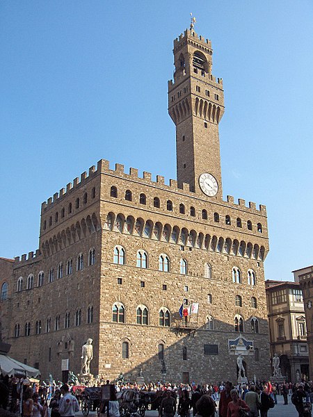
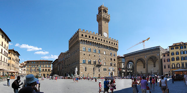
Palazzo Vecchio, also known as the Palazzo della Signoria, is a historic palace and town hall located in the heart of Florence, Italy. It is one of the most significant and iconic buildings in Florence and has played a central role in the city’s political and cultural life. Here are some key details about Palazzo Vecchio:
History: Palazzo Vecchio was built in the late 13th century and served as the seat of the Florentine government. It was designed by the renowned architect Arnolfo di Cambio.
Architecture: The palace is a prime example of medieval civil architecture and reflects a combination of Romanesque, Gothic, and Renaissance architectural styles. It features a crenellated tower and a prominent clock.
Location: Palazzo Vecchio is located in the historic center of Florence, in the Piazza della Signoria. It is surrounded by other significant landmarks, such as the Uffizi Gallery and the Loggia dei Lanzi.
Courtyard: The palace includes a stunning courtyard, known as the Cortile di Michelozzo, which is adorned with classical and Renaissance sculptures.
Art and Decorations: The palace’s interior is richly decorated with frescoes, sculptures, and other artworks, many of which are related to the history and government of Florence. The Hall of the Five Hundred (Sala dei Cinquecento) is particularly famous for its large-scale frescoes by Giorgio Vasari.
Tower: The tower of Palazzo Vecchio, known as the Arnolfo Tower, offers panoramic views of Florence and can be climbed by visitors.
Political Significance: The palace has historical significance as the center of Florence’s political life. It was once the seat of the Signoria, the governing body of the city, and now houses the Florence City Council.
Museum: Today, Palazzo Vecchio is also a museum, allowing visitors to explore its rich history, art, and architecture. The museum includes rooms like the Hall of Maps, the Studiolo of Francesco I, and the private quarters of the Medici family.
Courtyards and Gardens: The palace complex includes several courtyards and gardens, offering peaceful spaces to relax and enjoy the architecture.
Visiting Palazzo Vecchio is a chance to immerse oneself in the history and culture of Florence. The building’s unique blend of architectural styles and its role in the city’s governance make it a must-see for tourists interested in art, history, and Renaissance Italy.
Source : openai.com Visiting hours : 09.00 AM to 07.00PM Thursdays 9.00 AM to 02.00PM Ehtrance : https://shorturl.at/aiowC https://www.youtube.com/watch?v=YSu9ByrRYcE https://www.youtube.com/watch?v=lviNUxX8TXM
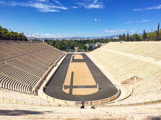
The Panathenaic Stadium is a multi-purpose stadium in Athens, Greece. One of the main historic attractions of Athens, it is the only stadium in the world built entirely of marble.
A stadium was built on the site of a simple racecourse by the Athenian statesman Lykourgos (Lycurgus) c. 330 BC, primarily for the Panathenaic Games. It was rebuilt in marble by Herodes Atticus, an Athenian Roman senator, by 144 AD and had a capacity of 50,000 seats. After the rise of Christianity in the 4th century it was largely abandoned. The stadium was excavated in 1869 and hosted the Zappas Olympics in 1870 and 1875. After being refurbished, it hosted the opening and closing ceremonies of the first modern Olympics in 1896 and was the venue for 4 of the 9 contested sports. It was used for various purposes in the 20th century and was once again used as an Olympic venue in 2004. It is the finishing point for the annual Athens Classic Marathon. It is also the last venue in Greece from where the Olympic flame handover ceremony to the host nation takes place.
The stadium hosted the opening ceremony of the 1997 World Championships in Athletics on a concept by composer Vangelis and along with the performance of soprano Montserrat Caballé.
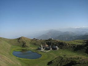
Sunrise view from Panchalimedu – Image Credit : Wikipedia
Panchalimedu is a hill station and view point near Kuttikkanam in Peerumedu tehsil of Idukki district in the Indian state of Kerala. On the Makar Sankranti day, lots of Ayyappa devotees camps there to witness the sacred Makaravilakku (holy flame) that appears in the Ponnambalamedu near Sabarimala temple.
Topography
Predominantly it is a high altitude region situated at a height of 2,500 ft (760 m) above the mean sea level. The place is surrounded by deep valleys and hills, accompanied by meadows, grasslands and cool refreshing climate. From there, the Koruthodu valley near Mundakkayam with widespread rubber plantations can be seen. Parunthumpara hills and Periyar tiger reserve lies to the east of Panchalimedu. Many tourists arrives there during the summer season for trekking and to get refreshed. When monsoon arrives, the place will be covered by charming mist and thick fog. Although, a pleasant climate is experienced here throughout the year. Apart from Pullumedu, Panchalimedu is another spot in the district where lots of pilgrims from the various regions gather to witness the Makaravilakku, a holy flame that is believed to a supernatural phenomenon by the devotees, which appears annually on January 14 in the Ponnambalamedu summit.
Location
Panchalimedu is located on the route to Kanayangavayal in the Azhutha block of Peerumedu tehsil. The place can be accessed from Murinjapuzha (5 km) and Amalagiri (6 km) on the Kottayam – Kumily state highway (K.K road). People from west and south can reach there through Mundakkayam – Thekkemala route. Jeep and auto services are available from Murinjapuzha at fair rates. There are two hills at Panchalimedu, one has the temple dedicated to Bhuvaneswari Devi and the other one have a main cross accompanied by 13 other crosses, which portrays the crucifixion of Jesus. The presence of these crosses and the temple marks the sign of religious harmony.
Nearby attractions Parunthumpara: It is about 22 km (14 mi) from here, situated at a height of 3,600 ft (1,100 m) from mean sea level and also a popular tourist destination in Idukki district. Peeru hills: It is a panoramic hill station named after ‘Peer Mohammed’, who was a Sufi saint. Valanjanganam falls: It is only 6 km (3.7 mi) from here, a scenic waterfall locally known as Ninnumullippara located on the route to Kuttikkanam from Mundakkayam. Valliyamkavu Devi Temple: This historic temple lies 10 km (6.2 mi) southeast to Panchalimedu and it is dedicated to Goddess Durga.
Source : wikipedia https://www.youtube.com/watch?v=QuDsQVEIvh8 https://www.youtube.com/watch?v=RoJ2-F0SSYo
Panchpula is situated at a distance of three kilometers from Dalhousie. One of the famous picturesque spots in the region, the word Panchpula means five bridges. On the there is a spring fall, which is known as the Satdhara spring fall. It is believed that the fresh waters of Satdhara contain healing medical properties. . Panchpula stream is the main source of water supply to Dalhousie and Bahloon. There is an elegant monument erected here where several streams meet at one point. This monument, a samadhi was built in memory of great revolutionary Sardar Ajit Singh who breathed his last here.
This place is suitable for trekking to Dain Kund to see the best natural beauty that lies hidden between the unexplored paths. Tourists can enjoy a break and enjoy the wonderful climate here. There are some food and tea stalls and government tourism restaurant situated around, where visitors can enjoy their trip by eating food, by clicking sightseeing etc. It is located at a short distance from gandhi chowk. so can easily reach there on foot.
The Pandoh Dam is an embarkment dam on the Beas river in Mandi district of Himachal Pradesh, India. Under the Beas Project, the dam was completed in 1977 and its primary purpose is hydroelectric power generation. Part of a run-of-thr-river power scheme, it diverts the waters of the Beas to the southwest through a 38 km (24 mi) long system of tunnels and channels. The water is used for power generation at the Dehar Power House before being discharged into the Sutlej River, connecting both rivers. The power house has an installed capacity of 990 MW. The system diverts 256 cumecs (9000 cusecs) of Beas waters to the Satluj River.
Pandoh Lake is created by Pandoh Dam and is located about 19 kilometres (12 mi) upstream from Mandi on the River Beas.
After Kapros one can find the idyllic landscape of Papafraga, one of the most impressive sites of Milos. From the top of the rock, it resembles a huge natural swimming pool, an enormous cave carved out of the cliff’s side. A tiny path leads to the tiny strip of sand that forms the beach.
Crystalline waters of changing colours, depending on the weather and the light, welcome the visitor and invite him to enjoy their coolness. Deep dark sea caves surround the place.
The most ancient site of Milos is just a few metres away: the amazing Papafragos Beach, the ancient town of Phylakope, the few remaining ruins of walls, buildings and tombs are now almost entirely covered by the water, but still bear witness of the life and civilization existing there during the Neolithic period.
Source : Greeka.com https://www.youtube.com/watch?v=k4yoTnRlt5Q https://www.youtube.com/watch?v=jLlIbSwhyBU Reviews https://bit.ly/3kwYmUp
Anappady, Parambikulam Road, Kerala 678661
Phone: 094422 01690
Image Credit : keralatourim.org
Parambikulam Tiger Reserve, which also includes the erstwhile Parambikulam Wildlife Sanctuary, is a 643.66 square kilometres (248.5 sq mi) protected area lying in Palakkad district and Thrissur district of Kerala state, South India. The Wildlife Sanctuary, which had an area of 285 square kilometres (110 sq mi) was established in part in 1973 and 1984. It is in the Sungam range of hills between the Anaimalai Hills and Nelliampathy Hills. Parambikulam Wildlife Sanctuary was declared as part of the Parambikulam Tiger Reserve on 19 February 2010. Including the buffer zone, the tiger reserve has a span of 643.66 km2. The Western Ghats, Anamalai Sub-Cluster, including all of Parambikulam Wildlife Sanctuary, has been declared by the UNESCO World Heritage Committee as a World Heritage Site. The Tiger Reserve is the home of four different tribes of indigenous peoples including the Kadar, Malasar, Muduvar and Mala Malasar settled in six colonies. Parambikulam Tiger Reserve implements the Project Tiger scheme along with various other programs of the Government of India and the Government of Kerala. The operational aspects of administering a tiger reserve is as per the scheme laid down by the National Tiger Conservation Authority. People from tribal colonies inside the reserve are engaged as guides for treks and safaris, and are provided employment through various eco-tourism initiatives. Parambikulam Tiger Reserve is among the top-ten best managed Tiger Reserve in India. The tiger reserve hosts many capacity building training programmes conducted by Parambikulam Tiger Conservation Foundation in association with various organisations.
Source : wikipedia https://www.youtube.com/watch?v=1gk6KK7KaJs https://www.youtube.com/watch?v=-H06ftf-i98 https://www.youtube.com/watch?v=OsoQCK2SvsA Reviews https://bit.ly/3on0eD5 Visiting hours : 0.700 AM to 04.00 PM For accommodation & Entry : https://bit.ly/3z4wzmS
This is a UNESCO world heritage site.
The Park Güell is a public park system composed of gardens and architectonic elements located on Carmel Hill, in Barcelona, Catalonia, Spain. Carmel Hill belongs to the mountain range of Collserola – the Parc del Carmel is located on the northern face. Park Güell is located in La Salut, a neighborhood in the Gràcia district of Barcelona. With urbanization in mind, Eusebi Güell assigned the design of the park to Antoni Gaudí, a renowned architect and the face of Catalan modernism.
Park Güell is designed and composed to bring the peace and calm that one would expect from a park. The buildings flanking the entrance, though very original and remarkable with fantastically shaped roofs with unusual pinnacles, fit in well with the use of the park as pleasure gardens and seem relatively inconspicuous in the landscape when one considers the flamboyance of other buildings designed by Gaudí. One of these buildings houses a permanent exhibition of the Barcelona City History Museum MUHBA focused on the building itself, the park and the city.
The focal point of the park is the main terrace, surrounded by a long bench in the form of a sea serpent. The curves of the serpent bench form a number of enclaves, creating a more social atmosphere. Gaudí incorporated many motifs of Catalan nationalism, and elements from religious mysticism and ancient poetry, into the Park. Much of the design of the benches was the work not of Gaudí but of his often overlooked collaborator Josep Maria Jujol.
The large cross at the park’s high-point offers the most complete view of Barcelona and the bay. It is possible to view the main city in panorama, with the Sagrada Família and the Montjuïc area visible at a distance.
The park supports a wide variety of wildlife, notably several of the non-native species of parrot found in the Barcelona area. Other birds can be seen from the park, with records including short-toed eagle. The park also supports a population of hummingbird hawk moths.
Source :wikipedia
Park Guell is one of the masterpieces of the Catalan architect Antoni Gaudi, who projected it in 1900. Inaugurated as a public park in 1926, it was listed as a UNESCO World Heritage Site in 1984, reconizing its patrimonial and cultural value as a symbol of modern architecture, being one of the biggest exponents of Gaudi’s modernism. This playful urban park, the work of architect Antoni Gaudi, features peaceful greens, winding paths and many sculptures and mosaics designed by Gaudi himself. We recommend the following options for ensuring that you arrive on time at the Park Guell Monument Precinct: – Metro (green line, get off at Lesseps or Vallcarca). When you leave the station, you’ll have a walk of about 20-25 minutes. – City bus (lines H6 and 32). When you get off the bus, you’ll have a walk of about 15 minutes. – City bus (lines 92 and 24). When you get off the bus, you’ll have a walk of about 5 minutes. – Barcelona City Tour and Bus Turistic. When you get off the bus, you’ll have a walk of about 10 minutes. – Taxi to Park Guell
Click On the Headlines Or the Image for the complete News, Videos and more photos.
Bayerische Motoren Werke AG German for Bavarian Motor Works, usually known under its abbreviation BMW , is a German luxury vehicle, motorcycle, and engine manufacturing company founded in 1916. It is one of the best-selling luxury automakers in the world. The company is a component of the Euro Stoxx 50 stock market index. Headquartered in Munich, Bavaria, the company owns Mini cars and is the parent company of Rolls-Royce Motor Cars. The company produces motorcars under the BMW Motorsport division and motorcycles under BMW Motorrad, and plug-in electric cars under the i sub-brand and the “iPerformance” model designation within the regular lineup……………………………………………………..
Source : wikipedia
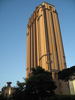
Parkview Square is an office building located in the Downtown Core Planning Area, Central Region, Singapore. It is situated along North Bridge Road, and is near the major commercial hub at Marina Centre. It is next to Bugis MRT Station, Bugis Junction, and The Gateway, and straddles the Rochor Road and Ophir Road corridor.
Parkview Square is one of the most expensive office buildings in Singapore. Parkview Square houses the Honorary Consulate of Oman on the 4th floor, Embassy of the United Arab Emirates on the 9th floor, as well as the embassies of Austria and Mongolia on the 24th floor of the building.
Parkview Square was designed by the US firm James Adams Design, together with DP Architects of Singapore.
It was built as the last major project enterprise by the late Mr. C. S. Hwang, a Taiwanese tycoon chairman of Chyau Fwu Group.
The office space on each floor is column-less so it can be reconfigured according to the tenant’s wish. Although it is a modern building, having been completed in 2002, it is specially designed in the classic Art Deco style, following New York City 1929 Chanin Building as an inspiration. The exterior surface of the building is clad in brown Granite, bronze, lacquer, and glass.
The lobby is also designed mainly in the Art Deco style and features a 15m-high ceiling with hand-crafted details. The bar in the lobby of the building has a unique 3-storey high wine chiller from which a female bar tender dressed as a fairy retrieves bottles on request by means of a flying wire apparatus.
The open plaza of Parkview Square is reminiscent of Piazza San Marco in Venice, with sculptures and statues surrounding the open plaza. There are many bronze effigies of some of the most famous figures in world history, including Sun Yat-Sen, Abraham Lincoln, Salvdor Dali, Mozart, Chopin, Isaac Newton, Pablo Picasso, Rembrandt, Shakespeare, Plato, Dante, Winston Churchill and Albert Einstein.
The building also has widespread use of motifs, sculptures, and ornamentation. The building is “guarded” by eight gigantic fiberglass statues of men holding a light ball in their hands, four of them standing on each broad side of the building’s crown. Another example is the gargoyles decorating the building’s exterior, which are said to be hand-crafted. Locally, the building is often referred to as “Gotham building”, due to its Art Deco architectural style that resembles the fictional Gotham City from the Batman series.
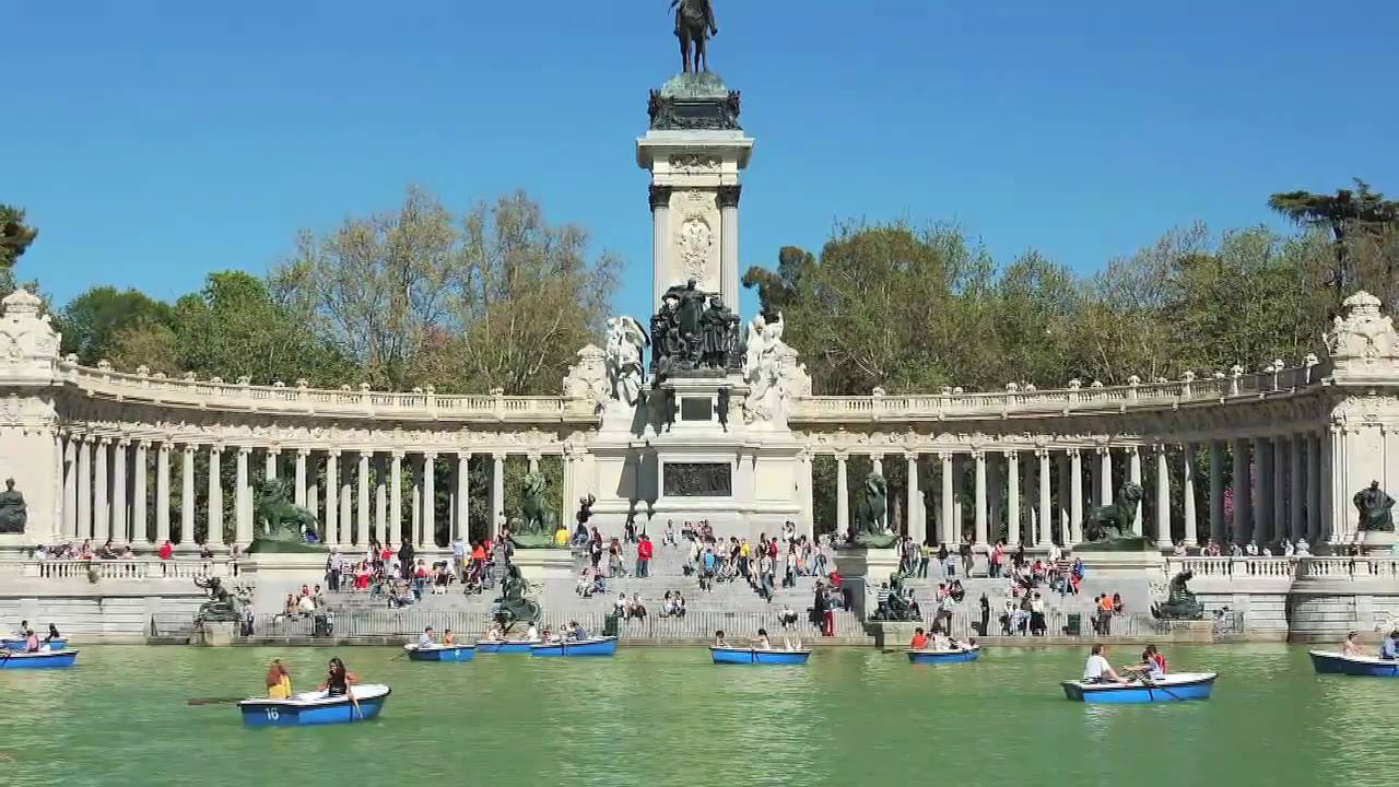
Plaza de la Independencia, 7, 28001 Madrid, Spain
Phone : +34 914 00 87 40
Image Credit : youtube.com
The Buen Retiro Park (Spanish: Parque del Buen Retiro, literally “Park of the Pleasant Retreat”), Retiro Park or simply El Retiro is one of the largest parks of the city of Madrid, Spain. The park belonged to the Spanish Monarchy until the late 19th century, when it became a public park.
The Buen Retiro Park is a large and popular 1.4 km2 (350 acres) park at the edge of the city centre, very close to the Puerta de Alcalá and not far from the Prado Museum. A magnificent park, filled with beautiful sculptures and monuments, galleries, a peaceful lake, and a host to a variety of events, it is one of Madrid’s premier attractions. The park is entirely surrounded by the present-day city.
Close to the northern entrance of the park is the Estanque del Retiro (“Retiro Pond”), a large artificial pond. Next to it is the monument to King Alfonso XII, featuring a semicircular colonnade and an equestrian statue of the monarch on the top of a tall central core.
The Rosaleda rose garden. Among the many rose bushes of all kinds stands the Fountain of the Fallen Angel, erected in 1922, whose main sculpture El Angel Caído (at the top) is a work by Ricardo Bellver (1845–1924) inspired by a passage from John Milton’s Paradise Lost, which represents Lucifer falling from Heaven. It is claimed that this statue is the only known public monument of Satan.
The few remaining buildings of the Buen Retiro Palace, including Casón del Buen Retiro and the Salon de Reinos, now house museum collections. The Casón has a collection of 19th- and 20th-century paintings, including art by the Spanish painter Joaquín Sorolla. The Ejército, one of Spain’s foremost Army museums, has moved to Toledo.
The Paseo de la Argentina, also popularly known as Paseo de las Estatuas (“Statue Walk”), is decorated with some of the statues of kings from the Royal Palace, sculpted between 1750 and 1753.
There are now art galleries in the Crystal Palace, Palacio de Velázquez, and Casa de Vacas.
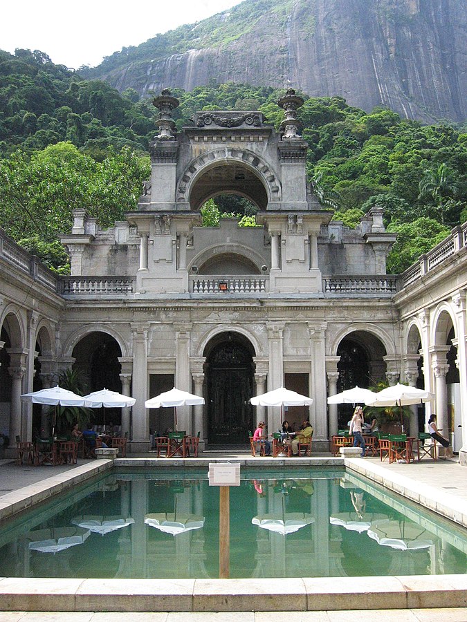
R. Jardim Botânico, 414 – Jardim Botânico, Rio de Janeiro – RJ, 22461-000, Brazil
Phone: +55 21 2334-4088
Image Credit : commons.wikimedia
Parque Enrique Lage is a public park in the city of Rio de Janeiro, located in the Jardim Botânico neighborhood at the foot of the Corcovado, on top of which Christ the Redeemer is located.
The land was formerly the residence of industrialist Henrique Lage and his wife, singer Gabriella Besanzoni. During the 1920s, Lage had the mansion remodeled by Italian architect Mario Vodret, with interior paintings by Salvador Payols Sabaté.
The National Historical and Artistic Heritage Institute (IPHAN) listed Parque Lage, on June 14 1957, as a historical and cultural heritage site for the city of Rio de Janeiro.
In the 1960s, the land became a public park, with walking trails through subtropical forest. The Escola de Artes Visuais do Parque Lage (Visual Arts School of Parque Lage) and a café open to the public operate from the former mansion.
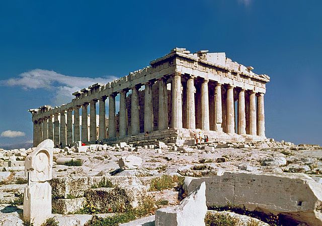
The Parthenon is a former temple on the Athenian Acropolis, Greece, dedicated to the goddess Athena, whom the people of Athens considered their patron. Construction began in 447 BC when the Athenian Empire was at the peak of its power. It was completed in 438 BC, although decoration of the building continued until 432 BC. It is the most important surviving building of Classical Greece, generally considered the zenith of the Doric order. Its decorative sculptures are considered some of the high points of Greek art. The Parthenon is regarded as an enduring symbol of Ancient Greece, Democracy and Western civilization, and one of the world’s greatest cultural monuments. To the Athenians who built it, the Parthenon, and other Periclean monuments of the Acropolis, were seen fundamentally as a celebration of Hellenic victory over the Persian invaders and as a thanksgiving to the gods for that victory.
The Parthenon itself replaced an older temple of Athena, which historians call the Pre-Parthenon or Older Parthenon, that was destroyed in the Persian invasion of 480 BC. Like most Greek temples, the Parthenon served a practical purpose as the city treasury. For a time, it served as the treasury of the Delian League, which later became the Athenian Empire. In the final decade of the 6th century AD, the Parthenon was converted into a Christian church dedicated to the Virgin Mary.
After the Ottoman conquest, it was turned into a mosque in the early 1460s. On 26 September 1687, an Ottoman ammunition dump inside the building was ignited by Venetian bombardment during a siege of the Acropolis. The resulting explosion severely damaged the Parthenon and its sculptures. From 1800 to 1803, Thomas Bruce, 7th Earl of Elgin removed some of the surviving sculptures, now known as the Elgin Marbles, with the alleged permission of the Turks of the Ottoman Empire.
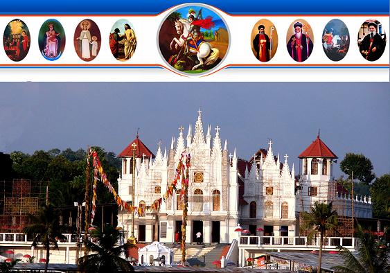
St. Peter’s and St. Paul’s Church, Parumala (Parumala Pally) is a prominent parish church of the Malankara Orthodox Syrian Church.
Parumala is a small stretch of land on the shores of the river Pampa. Malankara Metropolitan Joseph Mar Dionysius wanted to establish a seminary in this area. An ordinary building called ‘Azhippura’ was soon built here for conducting classes for the deacons etc. Syriac classes were begun here under the care of Fr.Yakob. In course of time, Metropolitan Mar Dionysius gave the charge of the seminary to Metropolitan Mar Gregorios (Later known as Parumala Thirumeni), in order to carry on the Syriac teaching sessions more efficiently and also to help him in other church matters.
Temporary church in Parumala was rebuilt by Mar Gregorios and consecrated in 1895.
Present church which can accommodate more than 2000 worshippers was consecrated on 27th October 2000.
Parumala church is the tomb church of Saint Geevarghese Mar Gregorios or Parumala Thirumeni. He died on 2 November 1902 at the age of 54. The funeral was conducted at Parumala on 3 November 1902 in the presence of thousands of people and hundreds of priests. Many testimonies to the saintly intercession of Mar Gregorios made Parumala Church and the tomb a centre of pilgrimage.
In 1947 Mar Gregorios of blessed memory was declared a saint by the Catholicos of the church, Baselios Geevarghese II.
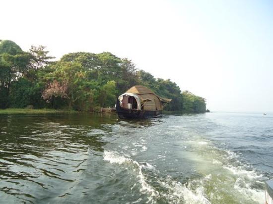
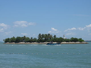
Pathiramanal is a small island in Muhamma Panchayat of Alappuzha district. The name ‘Pathiramanal’ means ‘sands of night’. The scenic beauty of both sides of the lake as well as that of the island is mind blowing. It is home to many rare varieties of migratory birds from different parts of the world.
The Pathiramanal Island is about 1.5 km from Muhamma boat jetty and about 13 km from Alapuzha. From the jetty close by Baker Bungalow the distance to the island is about 5 km and from Kumarakom 4 km towards northwest.
The island (also known as Anantha Padmanabhan Thoppu) was purchased by Chevalier ACM Anthraper, from M/s Bheemji Devji Trust of Cochin and was under the private ownership of Thaimattathil Family until the late seventies. In 1979 after Land Reforms Acts were enforced in the State, the property came under government ownership. The island was returned to the government as a surplus land that crossed the land ceiling. It was later transferred to the Tourism Department and the idea of leasing it out to private enterprises was under consideration. The island at present is uninhabited. Till late seventies of the 20th century 14 worker families resided in the island, who were later rehabilitated on the mainland in the Muhamma panchayath.
The island is an hour and half drive by motor boat or 30 minutes by speed boat from Alappuzha town. One can also take the boats plying in the Muhamma-Kumarako water route. It takes around 40 minutes from Kumarakom to reach Pathiramanal. The journey through Vembanad Lake is a marvellous experience.
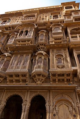
A group of apartments, Patwon-Ki-Haveli is one of the largest and most elaborate of Havelis in Jaisalmer and stands in a narrow lane. It is five storey high and is extensively carved. A part of this beautiful building is owned by the Department of Archaeology and Museum. There are remnants of some paintings on the walls inside as well as some mirror work. This has been the star attraction of Jaisalmer.
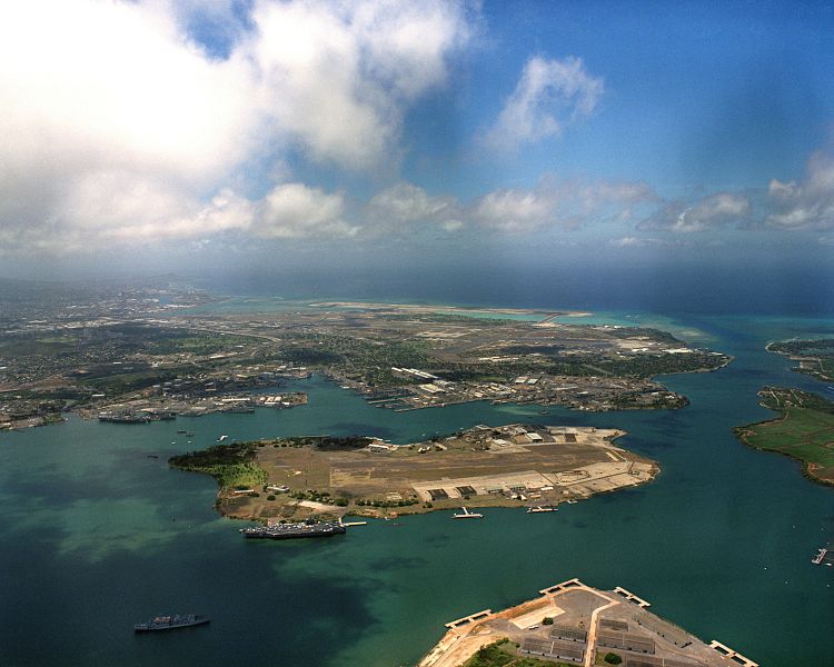
Pearl Harbor is a lagoon harbor on the island of Oahu, Hawaii, west of Honolulu. It has been long visited by the Naval fleet of the United States, before it was acquired from the Hawaiian Kingdom by the U.S. with the signing of the Reciprocity Treaty of 1875. Much of the harbor and surrounding lands is now a United States Navy deep-water naval base. It is also the headquarters of the United States Pacific Fleet. The U.S. government first obtained exclusive use of the inlet and the right to maintain a repair and coaling station for ships here in 1887. The attack on Pearl Harbor by the Empire of Japan on December 7, 1941, was the immediate cause of the United States’ entry into World War II.
Over the years, it remained a main base for the US Pacific Fleet after World War II along with Naval Base San Diego. In 2010, the Navy and the Air Force merged their two nearby bases; Pearl Harbor joined with Hickam Air Force Base to create Joint Base Pearl Harbor-Hickam.
On February 18, 2016, a tourist helicopter fell there, injuring four people; one person was missing and is thought to be dead.
In December 2016, Japanese Prime Minister Shinzo Abe made a joint visit to Pearl Harbor with US President Barack Obama. This trip marked the 75 year anniversary of the attack, and was the first official visit by a sitting Japanese leader.
Source : wikipedia https://www.youtube.com/watch?v=Uzdoo__v5Ew
Peechi Dam thrissur is situated 22 km (14 mi) outside Thrissur city in Kerala, India. The dam was started as an irrigation project for the surrounding villages in Thrissur. At the same time, it catered the drinking water needs of the population of Thrissur City. It serves as an irrigation dam, reaching out to the paddy fields in and around Thrissur city. Built across the Manali River, the dam has a catchment area of nearly 3,200 acres (1,300 ha). Elephants may be seen on the bank of Peechi-Vazhani Wildlife Sanctuary, established in 1958 covering 125 square kilometres (48 sq mi).
Source : wikipedia
The Peechi-Vazhani Wildlife Sanctuary is the ultimate destination for anyone enamoured with the intrinsic beauty of nature. Sprawling over a 125 sq.km complex, it lies about 20 km east of Thrissur. It is situated in the catchment area of the Peechi and Vazhani Dams. It is part of the Palapilli-Nelliampathy forests and forms the northern boundary of the Chimmini Wildlife Sanctuary.
The Peechi-Vazhani Sanctuary is blessed with many a picnic spot along with a plethora of boating options. The highest point here is the 923 m high Ponmudi which offers an excellent view of the underlying valley. There are more than 50 different kinds of orchids, exotic medicinal plants, teak and rosewood here. One can see over 25 species of mammals including the leopard, tiger, Sambar, deer, Spotted Deer, Indian Bison and Asian Elephant. More than 100 species of birds and several species of snakes and lizards are also found here.
These photos of Aquarium of Fisheries Research Institute is courtesy of TripAdvisor
Penang aquarium is located in the southeast tip of Penang Island, Batu Maung, Penang, Malaysia. It is situated right within the Fisheries Research Institute complex. This is one of the most tourist attractions in the fishing village of Batu Maung. The aquarium has a total of 25 tanks to showcase the large variety of marine life, especially those found in the regional waters. Among them are the lion fish, the box fishes, moray eels, tangs, surgeon fish, cat sharks, stone fish, angel fish, blue spotted stingray, fox face fish, parrot fish, squirrel fish, damsels, bivalves and more. The main attraction of the aquarium is the large tank with the measurement of 15ft by 10ft in one of the room. The room is like a big theatre showcasing big fishes including snappers, huge green turtle, tudung periuk and nyior nyior. Apart from fishes, there are also a display of different types of corals and sea anemones.
There are quite a few nearby attractions where you should pay a visit. One of them is the Snake Temple. The Snake Temple is one of its kinds. The temple features many poisonous snakes coiling around the pillar and plants in the temple. For all brave hearted people, you can even take an up close picture with the large snakes in the temple under the guidance of professional there. If you are looking for a place to relax your mind, do get to the nearby island with the name of Jerejak Island (Pulau Jerejak). It is a great getaway from the hustle of Georgetown. Jerejak Island is well known with its unique flora and fauna. It also acts as a habitat for eagles. There are tour packages which are filled with all kind of adventurous activities that get you near to the nature. The place recommended to be added on the list is Penang War Museum. The museum located near to the aquarium and it is a historical place. It was built by the British as fortress to protect from the invasion of Japanese but during the occupation of the Japanese, the place was turned into a place of tortures and interrogations. This place is definitely worth a visit to gain a unique experience that you never have before.
Source : http://penang.attractionsinmalaysia.com/
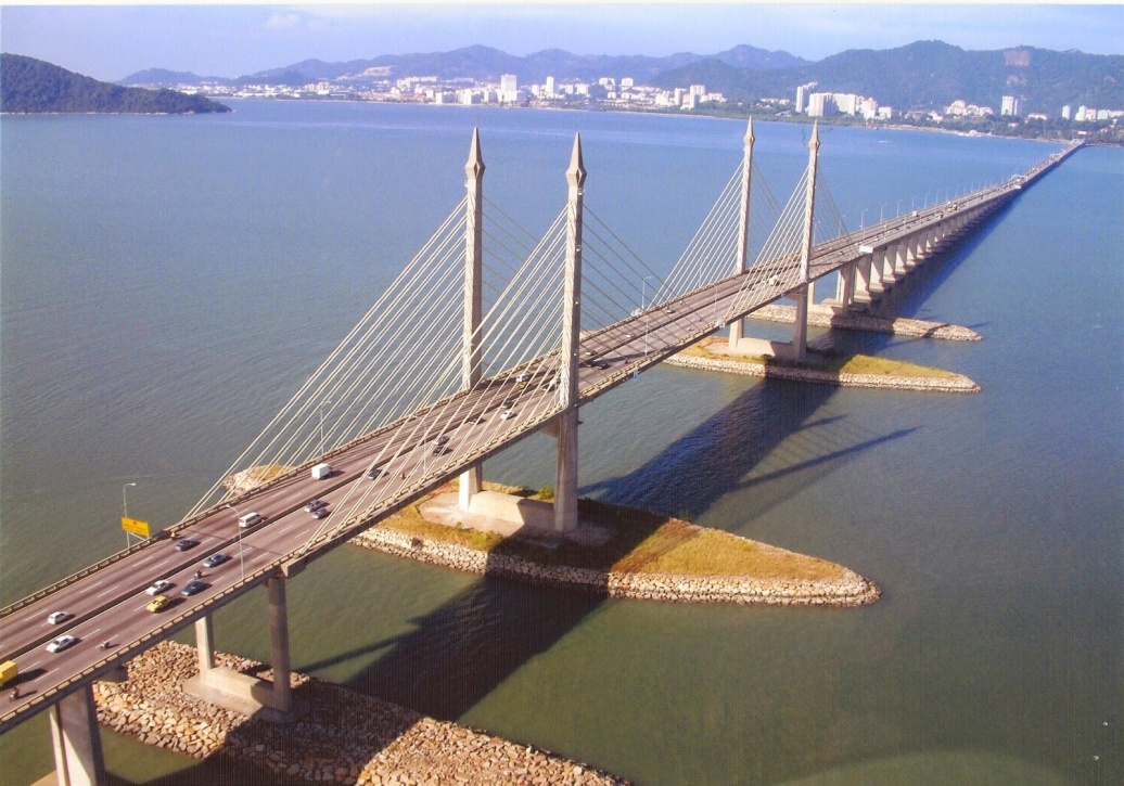
The Penang Bridge is a 13.5km (8.4-mile) dual carriageway toll bridge and controlled-access highway in the state of Penang, Malaysia. The bridge connects Butterworth on the mainland side of the state with Gelugor on the island, crossing the Selatan Strait. The bridge was inaugurated on 14 September 1985 and it is the first road connection between the peninsula and the island. The bridge is well known as the second-longest bridge in Malaysia and the fifth-longest in Southeast Asia by total length, with a length over water of 8.4 kilometres (5.2 miles). The current concession holder and maintainer of the bridge is PLUS Expressway.
Before the bridge was built, Penang Ferries carried passengers between Butterworth and George Town. In the early 1970s, the idea to build a bridge linking Seberang Perai to Penang Island was suggested by the 2nd Prime Minister of Malaysia’s Tun Abdul Razak and the 2nd Chief Minister of Penang’s Tun Dr Lim Chong Eu.
At the end of 1971, the Malaysian government appointed Christiani Nielsen A/S of Denmark to carry out a feasibility study. In the year 1976, Penang Bridge was planned during the term of 3rd Prime Minister of Malaysia’s Tun Hussein Onn.
In November 1976, Howard Needles Tammen & Bergendorf of USA in association with Jurutera Konsultant (SEA) Sdn. Bhd. of Malaysia was appointed to design and supervise the construction of the bridge.
On 23 July 1981, Works Minister of Malaysia’s Dato Seri Samy Vellu announced that Penang Bridge, Penang would be constructed using the cable-stayed concrete girder of the San Francisco’s Golden Gate Bridge instead of the steel-tied arch in the style of the Sydney Harbour Bridge.
Source : penangbridge.com.my
Route description
The route begins at the Penang Bridge interchange with the North–South Expressway Northern Route and Jalan Perusahaan Perai. The route then briefly goes southwest, where island-bound commuters proceed to pay the bridge toll. At the shore where the bridge begins, the route turns westwards, crossing the Selatan Strait. In the middle of the bridge, the route bends slightly northwest towards Gelugor. On the island side, the route ends at the shore at its interchange with the Tun Dr Lim Chong Eu Expressway and the Gelugor Highway.
Jalan Teluk Bahang, 11050 George Town, Pulau Pinang, Malaysia
Phone : +60 4-888 8111
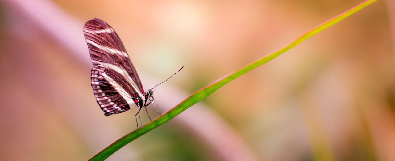
Source : entopia.com
Since opening Entopia’s doors to the public in March 1986, Penang Butterfly Farm – the first tropical butterfly exhibition in the world – has played host to over 4 million visitors. Inspired by our conversations with visitors and academia near and far, we have built on our rich heritage to create the ultimate “Nature Learning Destination”.
It is this same desire to help people live in better harmony with nature that led to our rebirth as ENTOPIA. Imagine nature’s largest classroom and discovery hub, where the butterflies and insects are free to come out to play. This is our very own Entomological Utopia.
Intrinsic value
Butterflies and moths are the second most abundant species of insects in the world, after the beetles.
Butterflies exist on all continents except Antarctica.
Butterflies have a long natural history on Earth. Scientists have discovered butterfly fossils, one being Prodryas persophone, dating back 40 million years ago.
However, scientists suggest that butterflies evolved along with the development of flowering plants during the Cretaceous Period about 65-135 million years ago. Aesthetic value
Generally, butterflies are known to be the most beautiful insects in the world.
Artists, designers, poets and songwriters have been using butterflies as subjects and inspirations in their work.
In some cultures, butterflies are often portrayed as symbols of souls, freedom, love and peace. Educational value
The butterfly’s life cycle is often used as a teaching tool in Science for young children. The transformation process from caterpillar to pupa is one of the most marvelous wonders in nature.
The butterfly is also used in early studies to show an insect’s body parts. Economic value
Studying the arrangement of scales on butterflies’ wings have inspired researchers to invent solar panels.
Butterfly farming encourages eco-tourism. Ecosystem value
Butterflies are important pollinators to most agricultural crops.
In addition to their ecological niche, butterflies are also a food source to predators like birds, spiders, lizards and other animals.
Source : entopia.com
Penang Butterfly Farm, established in 1986 is to function as a tourist destination and to serve as a centre for education, recreation and scientific research. In order to safeguard the various species of butterflies on the island, this conservation centre is dedicated to protecting them and their habitat. The Farm has gained an international reputation within the industry. Today, the Penang Butterfly Farm is the first tropical butterfly farm in the tropical world, with an average flying population of 4000 Malaysian butterflies of 120 different species, including the rare Indian leaf wing (Kallima paralekta) and the endangered Yellow Bird wing( Trides Helena).
The Penang Hill Railway is a one section funicular railway which climbs the Penang Hill from Air Itam, near George town on the island of Penang in Malaysia. The railway first opened in 1923 as a two-section railway, and the system was overhauled in 2010. The total journey time can take between five to twenty minutes. The funicular train coach travels directly from the lower station to the top, but may stop at other intermediate stations upon request.
Go explore the forests of Penang Hill, and discover interesting plants such as tropical oak trees and also the interesting carnivorous pitcher plant. Marvel at the tree Ferns and cycads which remained largely unchanged since the Jurassic period!
The Pitcher plant, a member of the Nepenthes genus, is locally known as the Monkey Cup. True to its name, the plant produces pitchers at the tips of their leaves.
Innocent as it may appear, the pitcher is actually a deadly trap. The rim of the pitcher produces a secretion which attracts insects to it. As insect lands on the slippery rim, it experiences a slippery landing, right into the pool of water at the base of the pitcher.
This liquid contains a digestive enzyme, which will slowly digest and turn the insect into a broth. The decomposed product is then absorbed by the plants as food.
The species commonly found in Penang Hill is the Nepenthes albmarginata, which has a white ring just below the rim, as the name ampl
If asked to suggest the name of a flower that would best represent Penang Hill, or for that matter Penang Island, it would be the orchid flower Paphiopedilum barbatum or Slipper Orchid. The flower is known and sought after throughout the world.
In earlier days, the plant could be found growing luxuriantly on rocks in the cool, shady environment of the hill forest. Unfortunately these plants are being stripped from their natural habitat and exported overseas where they are in great demand. It is indeed sad that this has to happen.
Source : penanghill.gov.my
Fauna
THE DUSKY LEAF MONKEY
The dusky leaf monkey is also known as the spectacled langur, or spectacled leaf monkey. They are very cute looking creatures. There are large white circles ringing each eye giving the appearance of sporting eyeglasses, with a thatch of light fur crowning its head. In addition to the white circles around each eye, the dusky leaf monkey also has white skin surrounding its mouth and creamy white colouring on its stomach region. The hands and feet are capable of grasping and closely resemble those of humans. The palms and soles are hairless and usually black. Newly born dusky leaf monkeys are bright yellow or orange in colour, and have a pink face; the fur changes to a greyish colour within six months
THE BLACK GIANT SQUIRREL
The Black Giant Squirrel is one of the largest squirrels in the world. It inhabits tall primary forest and generally remains high in the canopy, but at times may be found at lower levels when feeding. It is largely solitary in habits and extremely shy, rarely coming to ground. It can confidently make huge leaps from branch to branch in the high canopy. Its upperparts and tail are jet black, but the cheeks, chest, front of the forelimbs and underparts are cream or orange. The tail is long and dorso-ventrally flattened. Fruits, seeds and young leaves make up its diet, supplemented by occasional insects and sometimes birds eggs. It builds a large, spherical nest of leaves and twigs.
GREATER RACKET-TAILED DRONGO
The greater racket-tailed drongo is a medium-sized Asian bird which is distinctive in having elongated outer tail. The tail streamers can be up to 30 cm long. The whole bird looks black. The upper parts are glossy blackish blue and the underparts do not have the glossy except for the throat and breast. Bill black with short rough crest. Eyes are red. The tails is slightly forked with two bare tail streamers that end in a twisted racket of a feather. The tail streamers can sometime be missing or broken off. It is a noisy bird and mimics other bird calls. Can be sighted along the Summit Road and By-paths of Penang Hill.
Source : penanghill.gov.my
VIEWING DECK
At the apex of the hill near to the train station the focus is on enhancing visitors experience, maximizing the stunning views and resolving space needs. Both soft and hard landscaping have been extensively used to augment the hilltop forest experience. The holding area has been expanded for shade and shelter while large viewing decks and pathways with luxuriant planting have been fashioned into the slopes to create a journey of discovery. Three viewing decks with gardens at varying heights provide changing panoramic vistas while two additional platforms at the lower level allow rest under natural forest shading. The Skyway will allow stunning 360° views while fulfilling all accessibility needs.
Source : penanghill.gov.my
SRI ARULOLI THIRUMURUGAN (Penang Hill Hindu Temple)
Sri Aruloli Thirumurugan, or better known as the Penang Hill Hindu Temple, is one of the oldest Hindu temples in Penang. It started off in the 1800’s as a small shrine to the Hindu deity Murugan – the deity associated with Thaipusam – by the Indian sepoys and sedan chair carriers, and is located at a mount within Penang Hill called Gun Hill. A trident, or Murugan Vel, was installed there by the devotees. Over the years, it was enlarged and rebuilt. The present-day incarnation of the Sri Aruloli Thirumurugan is a very ornate Hindu temple in the Dravidian architectural style of South India.
The Dravidian style of constructing Hindu temples calls for four principal parts. The temple proper, or vimana, is the shrine with a tower, a mandapa, or porch, gopurams, or gate towers, and chawadis, or pillar halls. In addition, there would usually be a tank of water for use in sacred rituals or for cleansing.
Source : penanghill.gov.my
MOSQUE
Penang Hill Mosque, or Masjid Bukit Bendera, is the only mosque on Penang Hill. Erected to the use of Muslims living and working on the hill, the mosque is located at a short distance from the Penang Hill Hindu Temple. The majority of users of the mosque are those working at the stalls near the Penang Hill Railway Station, government servants attached to the post office, and other departments on Penang Hill.
The Penang Hill Mosque brings Islamic architecture to the otherwise colonial buildings of Penang Hill. Its minarets and domes stand in stark contrast to the surroundings, balanced only by the existence of the Hindu temple nearby.
Source : penanghill.gov.my
HISTORICAL HERITAGE
Bel Retiro is a government bungalow on Penang Hill. It was built in 1789 for the governor of Penang, and remains within the exclusive use of the government. It is the most prestigious property on Penang Hill, built in the 1800s as a resort for high government officials and visiting dignitaries. Bel Retiro Bungalow was the favourite retreat of the first Yang di-Pertuan Agung and Tunku Abdul Rahman whenever they visit Penang. Senior government officers built their bungalows close to Bel Retiro, on the principle of closeness is next to greatness.
Although the bungalow itself is out-of-bounds to the general public, one can hike up to its gate, a beautiful brick structure with an arch entranceway.
Visitors can go all the way to the gateway of the Bel Retiro Bungalow but no farther as it is private property.
Getting there : Take the Penang Hill Railway to reach Penang Hill then walk along the main road, Jalan Tuanku Yahya Petra until the Penang Hill Police Station. From the Penang Hill Central Square, climb the hill towards the Penang Hill Mosque. Bel Retiro is located just beyond the mosque.
Source : penanghill.gov.my
OWL MUSEUM
Opening hours:
Normal days : 9.00am to 7.00pm
Weekend and public holiday : 8.00am to 9.00pm
Entrance fee :
Adult : RM 12.00
Senior Citizen : RM 6.00
Kids (Above 7 years old) : RM 6.00
Kids (Below 7 years old) : Free
(Total price is inclusive of GST)
The museum’s owls are made from a myriad of materials such as wood, stone, metal, glass, clay, plastic, buffalo horn, seashells, beans, plant fibres, crystal, porcelain, earthenware, paper and recycled items. Special collections on loan from private collectors are also on display.
For more information please contact 04-826 5704
Source : penanghill.gov.my
HENNA ART
Adorn yourself with the art of henna tattoos from the famous Penang Hill Henna Artists. They have been providing amazing and quality work for years since 1994. Their services include face painting, body art and super-fast airbrush tattoos. This henna artist uses all-natural and safe ingredients for a one-of-a-kind piece of body art. Have a patch on you !
Source : penanghill.gov.my
LOVE LOCK
Tour Malaysia’s contribution to the world’s legacy of love as you stands 823 metres above sea level on the observation deck of the Bukit Bendera. Aptly launched on Valentine’s Day of 2014, the lover’s promenade hosts the promises of eternity for couples who seal their affection with creatively-decorated padlocks. There’s no place more suited to profess your love than at Love Lock Penang Hill.
Source : penanghill.gov.my
WAX
Wax Hand is a unique form of souvenir-cum-memorabilia merchandise in Penang Hill. Dip your hand into the liquid wax and create your own art form hand impression. The experience of having your hand made out of wax with your loved ones will increase the sentimental value of the product beyond the price. Virtually any pose formed by the hand can be made. If undecided, you can also imitate the poses from their display showcases. For double hands, both hands are required to be paired up to replicate the best effect. Again, the Wax Hand staffs will guide the pair of hands to form an attractive and befitting pose. Their wax is specially formulated not to cause any harmful reactions to the skin. From their countless experiences, even babies have undergone the waxing process unharmed. Your colourful molded souvenir impression can be taken home and enjoyed by your friends and family.
Jalan Hassan Abas, Teluk Bahang, 11050, Pulau Pinang, Malaysia
Phone : +60 4-881 3530
This photo of Penang National Park is courtesy of TripAdvisor
The Penang National Park spans 1,213ha of land and sea and is used by scientists, researchers, and nature lovers to explore its natural treasures.
Previously known as the Pantai Acheh Forest Reserve, this pristine site is known to harbour 417 flora and 143 fauna species. Pantai Acheh Forest Reserve, located at the northwestern tip of Penang, was declared the Penang National Park in April 2003.
Natural attractions of Pulau Pinang National Park include the hill / lowland dipterocarp forests, mangrove forest areas, sandy beach habitats, a seasonal meromictic lake and the open coastal seas. Stands of seraya (Shorea curtisii) trees, common feature of coastal dipterocarp forest, can be easily seen on steep slopes around Muka Head. There are over 1000 species of plants recorded which are dominated by the families Dipterocarpaceae ,Leguminosae, Apocynaceae, Anacardiaceae, Euphorbiaceae and Moraceae.
Source : Wikipedia
If you don’t feel like walking into the forest you can hire boats at the entrance to take you around the coast. Prices for hiring the whole boat (for up to 10 people) are currently 50RM for Monkey Beach to 100RM to take you around the peninsular to the turtle sanctuary.A popular trip is to take a sunset cruise around the peninsular to Pantai Kerachut where if you’r lucky you may catch a spectacular unset.
Visiting hours : 07.30AM to 06.00PM , all days of the week
Entry fee : There is no entrance fee for visitors to Taman Negara Pulau Pinang. However, for canopy walkway activity, the fee charged for adults is RM5.00 and RM3.00 forchildren.
Getting there : Bus 101 and 102.
The main entrance to the park is through Telok Bahang while the second entrance point located at Kuala Sungai Pinang, Balik Pulau. Recreational facilities for visitors are only available at Pantai Kerachut, Sungai/Teluk Tukun, Pasir Pandak, Teluk Aling, Teluk Duyung dan Muka Head Light House. A nature trail also looped around the unique meromictic lake at Pantai Kerachut.
Jalan Tanjung Bunga, 11200 Tanjung Bungah, Pulau Pinang, Malaysia
Phone:+60 12-460 2096
Image Credit : youtube
Penang Toy Museum is a toy museum located at 1370, Mk 2, Teluk Bahang (Next to SJK (C) Eok Hua School), Penang, Malaysia. With more than 110,000 toys, dolls and other collectible items, it is the largest toy museum in the world. The 1,000 square meters museum, opened in 2005, was also recognised by the Malaysian Book of Records as the first toy museum in the country. The museum is visited by an estimated 100,000 visitors each year.
The Penang Toy museum features more than 110,000 toys and figures. There are another 30,000 toys that are kept in storage as the museum is not big enough to accommodate all of the toys. Some of the toys displayed in the museum were obtained direct from Hollywood.[2]
The museum features a notable 1.8m-tall Japanese Gundam robot, which cost RM9000. Other life size figures include Batman, Indiana Jones, Iron Man, Jack Sparrow, King Kong, Kung Fu Panda, Lara Croft, Monsters, Inc. characters, Power Rangers, Sheriff Woody, Shrek, Silver Surfer, Spider-Man, Superman, WALL-E and others.
The toy collections include Disney’s characters such as 101 Dalmatians, A Bug’s Life, Lilo & Stitch, Peter Pan, Pinocchio, Snow White and the Seven Dwarfs, The Incredible Hulk, The Lion King and The Little Mermaid. Also featured are Barbie dolls, Doraemon, Dragon Ball, the Fantastic Four, Frankenstein, Garfield, the Hulk, Looney Tunes characters, Mr. Bean, Pokémon toys, Snoopy, Spider-Man, Superman, WWE figures, X-Men figures and others.
The walls and ceiling of the museum are decorated with an Egyptian theme, featuring Pharaoh and sphinx statues. Museum Sections
Cave of Dinosaurs
Chamber of Comic Book Heroes
Chamber of Fantasy
Chamber of Horrors
Chamber of Monsters
Fields of Combat
Hall of Beauties
Hall of Cartoons
Hall of Celebrities
Hall of Rock Legends
Hall of Virtual Reality
Star Wars Collections
Get to know Singapore’s vibrant Peranakan community and history at this top-notch museum, filled with fine artefacts and fun exhibits.
It’s safe to say that the Peranakan Museum is the go-to destination for Peranakan heritage and culture. It houses what is reputedly the world’s finest collection of Peranakan artefacts – such as jewellery, furniture and textiles – in 10 permanent galleries over three floors.
Various aspects of this hybrid Southeast Asian culture – made up of Chinese, Malay and Indian elements – are brought to life here, through the interactive and multimedia exhibits.
Highlights include an elaborate 12-day Peranakan wedding, the stories of prominent Peranakans in Singapore’s history and how today’s Peranakans have evolved with their culture.
Their heritage is a tale of adaptation, after all. The term ‘peranakan’ means ‘locally born’ in Malay, and refers to the descendants of foreign traders who married local women in Southeast Asia centuries ago.
Singapore’s Peranakan community is mostly Peranakan Chinese, descendants of Chinese traders who settled in the busy ports of Penang and Singapore in the 19th century.
The Peranakan Museum is housed in a handsome old school. Now a National Monument, the former Tao Nan School was built in 1912, and was the first modern Hokkien school set up in the Straits Settlements.
A little-known fact: The building’s layout is based on Straits Settlements bungalows, where rooms sit around a central hall while toilets and kitchens are outside the main building.
Source : yoursingapore.com The different galleries are found in the following manner:
Gallery 1 (Level 1)
Galleries 2 – 5 (Level 2)
Galleries 6 – 10 (Level 3)
Special Exhibitions Galleries (Level 3)
Gallery 1 titled Origins provides an introduction to Peranakan culture and to various Peranakan communities in Singapore, Malacca, Penang and Southeast Asia. Visitors to the subsequent rooms will learn about the story of the traditional 12-day Peranakan wedding, where significant ceremonies like the lap chai (exchange of gifts) and chiu thau (coming of age) are presented. Visitors can also see the elaborate wedding chamber and a wedding procession taking place indoors on Level 2. Gallery 6 Nonya, features the arts and crafts of Nonyas like beadwork, along with a display on the Nonya kebaya, and the womenfolks’ role of transmitting cultural values to Peranakan children. Gallery 7 shows Religion, on Peranakans and their faiths. Gallery 8 illustrates the commerce, politics and social affairs of prominent Peranakans in Singapore’s history in this exhibition titled Public Life. Gallery 9 on Food and Feasting, provides a grand banquet setting with the world’s best collection of nonya porcelain. And finally the visual experience concludes with an introspection of modern Peranakans and how they feel about their heritage and the future of their culture in Gallery 10 (Conversations). Additional Special Exhibitions Galleries will feature changing specific-themed exhibitions.
Source : wikipedia
Perissa is a village on the island of Santorini, Greece. It is located 13 km to the southeast of Fira, near the Messa Vouno rock.
According to the 2011 census, Perissa has 678 permanent inhabitants. It is part of the community of Emporio.
Perissa boasts magnificent beaches on the Aegean including Perissa Beach itself. There are the remnants of the ancient Early Christian church of Saint Irene; its contracted form is the present name of the island, Santorini.
Source : Wikipedia https://www.youtube.com/watch?v=8jBfW6LdZsg https://www.youtube.com/watch?v=XX082UI-wqw https://www.youtube.com/watch?v=IatDdFm9M6A Reviews https://bit.ly/314z9bD
The beautiful Perissa Beach ,about 13 kilometers away from Fira lies at the base of Mesa Vouno Mountain that separates Perissa from Kamari
Perunthenaruvi waterfalls (also Perumthenaruvi) is located in the dense Sabarimala forest area, just 10 kilometres away from Erumeli, the renowned set off point for Sabarimala Pilgrimage. At Perumthenaruvi, water gushes through a gorge.The display is fantastic.The slant may ultimately reach about 100 ft height.Further, the water gracefully flows through areas of rocks, trees and wild flowers radiating a lovely feel. Great many bees, settled in the adjacent woods, have transformed here to a Kingdom of beehives. Naturally, the stream flowing through this area came to be called the great honey stream – Perunthenaruvi (also Perumthenaruvi) in local vernacular.
Mornings are the best time to visit here as strong sunshine tends to make the rocks hot. Perunthenaruvi, a picnic spot with a secluded feel, rarely gets crowded.
Source : keralatourism.org
Perunthenaruvi waterfalls lies in Vechuchira village of Pathanamthitta District. Once reached Vechuchira, take the approach road next to Navodaya School. The waterfall is at a walking distance of 5 minutes from the School. The nearest towns are Ranni at 12 Kilometres and Thiruvalla at 16 Kilometres, where accommodations and decent restaurants are available.
Jalan Petaling, 50000 Kuala Lumpur, Wilayah Persekutuan Kuala Lumpur, Malaysia
Phone : +60 3-2032 5988
Petaling Street is a China Town located in Kaula lumpur, Malaysia. Haggling is a common sight here and the place is usually crowded with locals as well as tourists.
The area has dozens of restaurants and food stalls, serving local favourites such as Hokkien mee, ikan baker (barbecued fish), asam laksa and curry noodles. Traders here are mainly Chinese but there are also Indian, Malay, and Bangladeshi traders.
There is a McDonalds on the 1st shop lot of Street. Also nearby is a Chinese bookshop. And there are the food stalls selling a variety of local food like Hainanese chicken rice and Noodles. Also nearby is the Jamek Mosque, an old mosque of Moorish architecture and also the tourist attraction known as Central Market all within walking distance. One of Kuala Lumpur’s famous landmarks, the Sri Mahamariamman Temple, Kuala Lumpur, is located along Jalan Tun H.S. Lee. It is one of KL’s oldest and richest Hindu temples, receiving many devotees and tourists daily. The area is served by the Pasar Seni LRT station of the Kelana Jaya Line and the Maharajalela Monorail station.
Petaling Street is still the best place to shop for counterfeit branded products and for trying out its large selection of local Chinese cuisine. For buyers, it is often possible to haggle on the price of watches, clothing and all the counterfeit items. The Street is always crowded not only with tourists, but also with locals.
Although not shot on site, Malaysia’s first period kungfu comedy, Petaling Street Warriors, is set against the backdrop of Petaling Street in the year 1908.
Getting there : Take the Kelana Jaya Line and get down at the Pasar Seni LRT Station. After getting down at the LRT station, a short walking distance will get you to Petaling Street.
Kuala Lumpur City Centre, 50088 Kuala Lumpur, Wilayah Persekutuan Kuala Lumpur, Malaysia
Phone : +60 3-2331 8080
Attribution : Erwinkarim
The Petronas Towers and the Kuala Lumpur Tower dominate the skyline of Kuala Lumpur’s Central Business District.
The Petronas Towers, also known as the Petronas Twin Towers , are twin skyscrapers in Kuala Lumpur, Malaysia. According to the Council on Tall Buildings and Urban Habitat (CTBUH)’s official definition and ranking, they were the tallest building in the world from 1998 to 2004 and remain the tallest twin towers in the world. The buildings are a landmark of Kuala Lumpur, along with nearby Kaula Lumpur Tower.
Tower One is fully occupied by Petronas and a number of its subsidiaries and associate companies, while the office spaces in Tower Two are mostly available for lease to other companies.
Suria KLCC
Entrance of Suria KLCCInside the Suria KLCC
Suria KLCC is a 140,000 m2 (1,500,000 sq ft) up market retail center at the feet of the Petronas Towers. It features mostly foreign luxury goods and high-street labels. Its attractions include an art gallery, a philharmonic theatre, an underwater aquarium and also a Science center. Suria KLCC is one of the largest shopping malls in Malaysia.
KLCC Park
KLCC Park
Spanning 17 acres (6.9 ha) below the building is the KLCC Park with jogging and walking paths, a fountain with incorporated light show, wading pools, and a children’s playground.
Skybridge
A skybridge connects the two towersAn inside view of the skybridge
The Petronas towers feature a double decker skybridge connecting the two towers on the 41st and 42nd floors, which is the highest 2-story bridge in the world. It is not attached to the main structure, but is instead designed to slide in and out of the towers to prevent it from breaking, as the towers sway several feet in towards and away from each other during high winds. It also provides some structural support to the towers in these occasions. The bridge is 170 m (558 ft) above the ground and 58 m (190 ft) long, weighing 750 tons. The same floor is also known as the podium, since visitors going to higher levels have to change elevators here. The skybridge is open to all visitors, but tickets are limited to about 1000 people per day, and must be obtained on a first-come, first-served basis. Initially, the visit was free but in 2010, the tickets started being sold by Petronas. Visitors can choose to opt for package one which is just a visit to the skybridge or go for package two to go to the skybridge and all the way to level 86. Visitors are only allowed on the 41st floor as the 42nd floor can only be used by the tenants of the building.
There is a two hinged arch that supports the skybridge with arch legs, each 51 metres (167 ft) long, that are bolted to level 29 of each of the towers. After being constructed on the ground, the skybridge was lifted into place on the towers over a period of three days in July 1995 but instead of being directly connected to the towers, the skybridge can shift or slide in and out of them to counterbalance any effect from the wind. Residing on the 41st and 42nd floors, the skybridge connects a conference room, an executive dining room and a prayer room.
Piazza della Repubblica is a lively square in the heart of Florence, Italy, known for its historical significance and vibrant atmosphere. Here are some key details about Piazza della Repubblica:
History: The square has a rich history dating back to Roman times when it was the site of the Roman Forum. Over the centuries, it underwent various transformations and served different purposes, including being the site of the city’s market.
Location: Piazza della Repubblica is centrally located in Florence, not far from the Florence Cathedral (Duomo) and the Florence Baptistery. It is a hub for both locals and tourists.
Architectural Highlights: The square is surrounded by notable buildings, including the historic cafes Gilli and Paszkowski, as well as the elegant Hotel Savoy. The arch known as the “Arcone” stands at the entrance to the square.
Cafes and Restaurants: Piazza della Repubblica is home to several cafes and restaurants, making it a popular spot for people-watching and enjoying a meal or a coffee.
Shopping: The square is surrounded by shops and boutiques, adding to its lively and bustling atmosphere. It’s a great place for shopping and exploring local stores.
Carousel: In the center of the square, you’ll find a traditional carousel, adding a touch of nostalgia and charm to the surroundings. It’s a favorite for families and children.
Street Performers: The square often features street performers, musicians, and artists, contributing to the lively and entertaining ambiance.
Events and Festivals: Piazza della Repubblica is a venue for various events, festivals, and cultural activities throughout the year. It hosts celebrations, markets, and concerts.
Historical Markers: While the square has a modern look, there are historical markers and remnants that remind visitors of its rich past, including the ancient Roman columns near the arch.
Nightlife: In the evening, Piazza della Repubblica comes alive with a vibrant nightlife. The cafes and restaurants create a lively atmosphere, and the square is beautifully illuminated.
Piazza della Repubblica serves as a central meeting point in Florence, offering a blend of history, culture, and modern city life. Whether you’re looking to shop, dine, or simply soak in the atmosphere, this square provides a dynamic and enjoyable experience for visitors.
Source : openai.com https://www.youtube.com/watch?v=KtSVcmSuJqs https://www.youtube.com/watch?v=vdu0v0GoptA
Piazza della Signoria is one of the main squares in the heart of Florence, Italy. It has been the political and civic center of the city for centuries and is surrounded by important landmarks, sculptures, and historical buildings. Here are some key details about Piazza della Signoria:
Location: Piazza della Signoria is located in the historic center of Florence, near the Arno River. It is a central and bustling square that serves as a hub for both locals and tourists.
Palazzo Vecchio: The dominant feature of the square is Palazzo Vecchio, the medieval town hall of Florence. This iconic building has a distinctive tower and serves as a symbol of the city’s political power.
Loggia dei Lanzi: Facing Palazzo Vecchio is the Loggia dei Lanzi, an open-air sculpture gallery. The loggia displays several impressive sculptures, including Benvenuto Cellini’s “Perseus with the Head of Medusa” and Giambologna’s “Rape of the Sabine Women.”
Uffizi Gallery: On one side of the square is the Uffizi Gallery, one of the most renowned art museums in the world. The gallery houses an extensive collection of Italian Renaissance art, including works by Michelangelo, Leonardo da Vinci, Botticelli, and Raphael.
Statue of David Replica: In front of the Palazzo Vecchio, there is a replica of Michelangelo’s famous statue of David. The original David is housed in the Accademia Gallery in Florence.
Fountain of Neptune: The Fountain of Neptune, located at the northern end of the square, is a notable Renaissance fountain featuring a statue of Neptune surrounded by sea nymphs and mythological figures.
Copy of the David by Michelangelo: In addition to the replica in front of Palazzo Vecchio, there is another copy of Michelangelo’s David at the entrance of the Palazzo Vecchio.
Cafes and Restaurants: The square is surrounded by cafes and restaurants, making it a lively and vibrant place to relax and people-watch.
Political and Cultural Hub: Piazza della Signoria has been the center of Florentine politics, commerce, and culture for centuries. It has witnessed historical events, public gatherings, and cultural celebrations.
Tourist Attraction: The square is a major tourist attraction, drawing visitors who come to admire its architecture, sculptures, and the vibrant atmosphere.
Piazza Navona is one of the most beautiful and well-known squares in Rome, Italy. Here are some key details about Piazza Navona:
Location: Piazza Navona is located in the historic center of Rome, not far from other iconic landmarks like the Pantheon and Campo de’ Fiori.
Design and Layout: The square is known for its impressive Baroque architecture and is famous for its elegant, elongated shape. It features three beautiful fountains: the Fontana dei Quattro Fiumi (Fountain of the Four Rivers) by Gian Lorenzo Bernini in the center, the Fontana del Moro (Moor Fountain), and the Fontana del Nettuno (Neptune Fountain) at the southern end.
Fontana dei Quattro Fiumi: The central fountain by Gian Lorenzo Bernini represents four major rivers from different continents: the Nile, Ganges, Danube, and Rio de la Plata. It’s a stunning work of art.
Fontana del Moro: The Moor Fountain features a central statue of a Moor wrestling with a dolphin, designed by Giacomo della Porta. It is located at the southern end of the square.
Fontana del Nettuno: The Neptune Fountain at the northern end of the square includes a statue of Neptune surrounded by sea nymphs. It was designed by Giacomo della Porta.
Art and Architecture: In addition to the fountains, Piazza Navona is surrounded by elegant buildings and is home to various art galleries, churches, and outdoor cafes. The Church of Sant’Agnese in Agone, designed by Francesco Borromini and Girolamo Rainaldi, is one of the notable landmarks on the square.
Events and Entertainment: Piazza Navona is often a lively place with street performers, artists, and vendors. It is particularly vibrant during various festivals and events throughout the year.
Piazzale Michelangelo is a famous square located on a hill in Florence, Italy. It offers some of the most breathtaking panoramic views of the city of Florence and the surrounding Tuscan countryside. Here are some key details about Piazzale Michelangelo:
History: Piazzale Michelangelo was designed by the architect Giuseppe Poggi in the 19th century. It was named after the renowned Renaissance sculptor and artist Michelangelo Buonarroti.
Location: The square is situated on a hill in the Oltrarno district on the south side of the Arno River, just a short distance from the historic city center of Florence.
Statue of David Replica: At the center of the square, there is a bronze replica of Michelangelo’s famous statue of David. This statue is a symbol of Florence’s artistic legacy.
Panoramic Views: Piazzale Michelangelo is famous for its panoramic views of Florence. From this vantage point, you can see many of the city’s iconic landmarks, including the Florence Cathedral (Duomo), Palazzo Vecchio, the Arno River, and the rolling hills of Tuscany.
Stairs and Paths: Visitors can reach the square by walking up a series of stairs, which lead from the city center up to the hill. There are also winding pathways that offer a more leisurely ascent.
Sunset Views: Piazzale Michelangelo is a particularly popular spot to watch the sunset, as the fading light bathes Florence in a warm and romantic glow. Many tourists and locals gather here in the evening to enjoy the view.
Cafes and Restaurants: The square has a few cafes and restaurants where you can enjoy a drink or a meal while taking in the views.
Events and Performances: Occasionally, Piazzale Michelangelo hosts cultural events, performances, and local markets.
Lake Pichola, situated in Udaipur city, is an artificial fresh water lake, created in the year 1362 AD, named after the nearby Picholi village. It is one of the several contiguous lakes, and developed over the last few centuries in and around the famous Udaipur city. The lakes around Udaipur were primarily created by building dams to meet the drinking water and irrigation needs of the city and its neighborhood. Two islands, Jag Niwas and Jag Mandir are located within Pichola Lake, and have been developed with several palaces to provide views of the lake.
There are four islands on the lake:
Jag Niwas, where is built the Lake Palace.
Jag Mandir, with the palace of the same name.
Mohan Mandir, from where the king would watch the annual Gangaur festival celebration.
Arsi Vilas, small island which was an ammunition depot, but also a small palace. This one was built by one of the maharanas of Udaipur to enjoy the sunset on the lake. It is also a sanctuary catering to a variety of birds, including tufted ducks, coots, egrets, terns, cormorants and kingfishers.
Three of the numerous lakes found in the vicinity of Udaipur which connect with the Pichola lake and the Saroop Sagar Lake connected by an arched bridge built by Maharana Swaroop Singh (1842-1861) which in turn connects to the Fateh Sagar Lake, the crystal watered lake in the midst of tree lined hills and the smaller Arsi vilas.
Pin Valley National Park is a National park of India located within the Lahaul and Spiti district, within the Cold Desert Biosphere Reserve, in the Himalayas region, in the stateof Himachal Pradesh, in far Northern India.
Spreading south of Dhankar Gompa near the Tibetan border, the park marks the border between the formerly separate districts of Lahaul and Spiti. The elevation of the park ranges from about 3,500 meters (11,500 ft) near Ka Dogri to more than 6,000 metres (20,000 ft) at its highest point.
With its snow laden unexplored higher reaches and slopes, the Park forms a natural habitat for a number of endangered animals including the snow leopard and Siberian ibex.
Because of the park’s high altitude and extreme temperatures, the vegetation density is sparse, consisting mostly of alpine trees and groves of Himalayan cedar (Cedrus deodara). In summer, rare birds such as the Himalayan snowcock, Chukar partridge, Snow Partridge and Snowfinch flourish in the park.
Some plants within the park’s alpine habitats have significant medicinal properties. Twenty-two rare and endangered medicinal plant species, have been discovered in and around Pin Valley National Park, which are distributed over 10 different habitat types.
29, Church St, Georgetown, 10200 George Town, Penang, Malaysia Phone : +60 4-264 2929
Image credit : Youtube
The Pinang Peranakan Mansion in George Town, Penang, Malaysia, is a museum dedicated to Penang’s Peranakan heritage. The museum itself is housed within a distinctive green-hued mansion at Church Street, George Town, which once served as the residence and office of a 19th century Chinese tycoon, Chung Keng Quee.
The mansion contains thousands of Peranakan artifacts, antiques and collectibles, as well as showcasing Peranakan interior design and customs, such as the typical grand long dining table (Malay: tok panjang). Due to its unique architecture and interior design that reflect the lifestyles of the Peranakans in Penang, the mansion has been featured in television series and reality TV shows, such as The Little Nyonya, The Amazing Race and The Amazing Race Asia.
Source : wikipedia https://www.youtube.com/watch?v=1wtl4BpFPlI https://www.youtube.com/watch?v=qascEEwLrVA https://www.youtube.com/watch?v=ec4-9etTrGw Reviews https://bit.ly/2KaY9VX Visiting hours : Monday to Sunday including Public Holidays from 9:30 am to 5 pm Entry : Adults : RM20.00 │ Children (below 6) : Free
Pláka is the old historical neighborhood of Athens, clustered around the northern and eastern slopes of the Acropolis, and incorporating labyrinthine streets and neoclassical architecture. Plaka is built on top of the residential areas of the ancient town of Athens. It is known as the “Neighborhood of the Gods” due to its proximity to the Acropolis and its many archaeological sites.
Plaka is on the northeast slope of Acropolis, between Syntagma and Monastiraki square. Adrianou Street (running north and south) is the largest and most central street in Plaka and divides it into two areas: the upper level, – Ano Plaka – located right under the Acropolis and the lower level – Kato Plaka – situated between Syntagma and Monastiraki.
Plaka is visited by hundreds of thousands of tourists around the year, and is under strict zoning and conservation regulations, as the only neighborhood in Athens where all utilities (water, power, cable television, telephone, internet, and sewage) lie underground in fully accessible, custom-made tunneling.
Plaka Castle, often referred to as the “Venetian Castle of Milos,” is the last remaining artefact on the Greek Island of Milos, which bears testament to the ancient times of Venetian rule. Make the short climb to the top of the mountain from the small town of Plaka below, and embrace the spectacular 360-degree views of the entire island, stretching as far as the eye can see. There is no better way to experience the entirety of Milos than here, and a visit is certainly a must-do for anyone traveling to the island.
Source : beatmypath https://www.youtube.com/watch?v=Hl1Njc6NWHo https://www.youtube.com/watch?v=a-sk-YGiwVQ Reviews https://bit.ly/3dTlBpy
Plaça de Catalunya or “Catalonia Square”; is a large square in central Barcelona that is generally considered to be both its city centre and the place where the old city (see Barri Gòtic and Raval, in Ciutat Vella) and the 19th century-built Eixample meet.
Some of the city’s most important streets and avenues meet at Plaça Catalunya: Passeig de Gràcia, Rambla de Catalunya, La Rambla, and Portal de l’Àngel, in addition to Ronda de Sant Pere, Carrer de Vergara, and Carrer de Pelai. The plaza occupies an area of about 50,000 square metres. It is especially known for its fountains and statues, its proximity to some of Barcelona’s most popular attractions, and the flocks of pigeons that gather in the centre.
Plaça Catalunya hosts quite a few interesting sculptures representative of Noucentisme, Neo-Classicism and different avant-garde movements.
Goddess , by Josep Clarà .
Pastor de Pau , by Pablo Gargallo .
Francesc Macia Monument . It reads: “Catalunya a Francesc Macià “.
Josep Llimona’s sculptures.
The Plaza de Cibeles is a square with a neo-classical complex of marble sculptures with fountains that has become an iconic symbol for the city of Madrid. It sits at the intersection of Calle de Alcalá (running from east to west), Paseo de Recoletos (to the North) and Paseo del Prado (to the south). Plaza de Cibeles was originally named Plaza de Madrid, but in 1900, the City Council named it Plaza de Castelar, which was eventually replaced by its current name.
It is currently delimited by four prominent buildings: the Bank of Spain, the Palacio de Buenavista, the Palace of Linares (“Palacio de Linares”), and the Cybele Palace (“Palacio de Cibeles”). These constructions are located in four different neighbourhoods from three different adjacent districts: Centro, Retiro, and Salamanca.
Over the years, Cybele Palace and her fountain have become symbolic monuments of the city.
The fountain of Cybele is found in the part of Madrid commonly called the Paseo de Recoletos. This fountain is named after Cybele, a Phrygian goddess.
Plaza de España (Spanish for Spain Square) is a large square, a popular tourist destination located in central Madrid, Spain at the western end of the Gran Vía. It features a monument to Miguel de Cervantes Saavedra and is adjacent to two of Madrid’s most prominent skyscrapers. Additionally, the Palacio Real (Royal Palace) is only a short walk south from the plaza.
Right in the center of the square is the monument to Miguel de Cervantes, a sculptural group that was made at the same time as the urbanization of the square itself. Around the monument, a series of landscaped spaces were created for the enjoyment and rest of the passers-by.
In front of the statue of Don Quixote and Sancho Panza, a pond of rectangular form is located that forms one of the most typical views of the Spanish capital, since just behind it see the buildings of Torre de Madrid and Edificio España. Initially, the statues of Don Quixote and Sancho Panza were located, approximately, in what is now the center of the pond, since it was later made. The constructive part of the monument is elaborated in granite, while the sculptural part was decided to be made in red stone from Sepúlveda (and some additions in bronze).
Source : wikipedia https://www.youtube.com/watch?v=PedT0Nt1wd8 https://www.youtube.com/watch?v=g-qGyYy08sc Reviews http://bit.ly/2XAzdwq
The Plaza de la Villa (formerly Plaza de San Salvador ) is located in the historic center of Madrid ( Spain ), next to the main street . In it, there are three small streets, corresponding to the primitive medieval layout of the city: El Codo appears on the east, the Cordon on the south and Madrid on the west.
In its outline are the main facades of three buildings of great historical-artistic value, built in different centuries. The oldest is the House and Tower of Lujanes ( XV century ), built in Gothic-Mudejar style, which is located on the eastern side of the square.
It is followed in antiquity by the Casa de Cisneros ( 16th century ), a plateresque palace that closes the southern part of the enclosure, and the Casa de la Villa ( 17th century ), in the Baroque style , one of the headquarters of the Madrid City Council , located in the western area of the plaza.
The Callao Square is located at the centre of the Spanish capital of Madrid.
Shaped in 1861, the square was formally opened in June 1866; its name remembers the May 1866 battle of Callao between the Spanish naval forces under the command of Casto Méndez Núñez and the Peruvian army.
The square was substantially and aggressively reformed in the 21st century. The reform removed nearly all elements present by that time, except the metro station access and a big tree, turning the square into a pedestrian and homogeneus space, while adding a limited number of pieces of urban furniture. Conversely, big screens were added to the surrounding buildings. Located in a very commercial area of the city, the pedestrian space is often for rent to companies wanting to carry out advertising events.
Source : wikipedia https://www.youtube.com/watch?v=Br-y6AFV_9g https://www.youtube.com/watch?v=1Z7jRc3RvNM Reviews http://bit.ly/2Gtue9V
The Plaza Mayor (English: Main Square) is a major public space in the heart of Madrid, the capital of Spain. It was once the centre of Old Madrid,. It was first built (1580–1619) during the Habsburg period of Philip III’s reign. Only a few Spanish blocks away is another famous plaza, the Puerta del Sol. The Plaza Mayor is for the people of Madrid and tourists to shop, walk around, eat, and enjoy the outdoors.
It dates back to the 15th century where it was originally called the “Plaza del Arrabal” and was used as the main market of the town. In 1561, the plaza was transferred to the city of Madrid.
There is a bronze statue of King Philip III at the center of the square, created in 1616 by Jean Boulogne and Pietro Tacca. Giambologna’s equestrian statue of Philip III dates to 1616, but it was not placed in the center of the square until 1848. The statue was a gift from the Duke of Florence at that time. It was Queen Isabel II ordered to move it from Casa de Campo to become the centerpiece of the Plaza Mayor.
Source : wikipedia https://www.youtube.com/watch?v=73ZiS6lWTZU https://www.youtube.com/watch?v=SKK0ZzwSaME https://www.youtube.com/watch?v=7P_H9wQ5p9Q
Pompeii is an ancient Roman city located near modern-day Naples in Italy. It is famous for its well-preserved archaeological remains and its tragic history. Here are some key details about Pompeii:
History: Pompeii was founded in the 6th century BC by the Oscan people and later became a Roman colony. In 79 AD, the city was buried under volcanic ash and pumice when Mount Vesuvius erupted. The eruption resulted in the tragic destruction of the city and the preservation of its remains.
Excavation and Preservation: The city’s remains were buried for centuries until they were rediscovered in the 18th century. Extensive excavations have taken place since then, revealing a remarkably well-preserved snapshot of daily life in ancient Rome.
Archaeological Site: Today, Pompeii is an archaeological site and open-air museum. It is one of the most visited and important archaeological sites in the world.
Buildings and Artifacts: Visitors to Pompeii can explore ancient Roman buildings, streets, houses, temples, shops, and other structures. Many of these buildings still have their original frescoes and mosaics intact, offering insights into the art and culture of the time.
Bodies of the Victims: The volcanic ash preserved not only buildings but also the shapes and even the bodies of some of Pompeii’s inhabitants. Plaster casts were made of these voids, allowing for a haunting and poignant glimpse into the final moments of the city’s residents.
Museums: In addition to the Pompeii archaeological site, there are several museums in the area, such as the Naples National Archaeological Museum, where artifacts and artwork from Pompeii are displayed.
Visiting Pompeii: Visitors can explore the ruins of Pompeii and learn about the city’s history through guided tours and exhibits. It’s a UNESCO World Heritage Site and an invaluable historical resource.
Mount Vesuvius: While in the area, tourists often take the opportunity to visit Mount Vesuvius, the volcano responsible for Pompeii’s destruction. There are hiking excursions to its summit for those interested in volcanology and geology.
Pompeii offers a unique window into ancient Roman life and the dramatic events that unfolded during the eruption of Mount Vesuvius. It continues to be a source of fascination and education for people from around the world.
Source : openai.com Visiting hours : 08.30 AM to 05.30 PM
Maharana Pratap Sagar located 50 kms from Kangra, in India, also known as Pong Reservoir or Pong Dam Lake was created in 1975, by building the highest earthfill dam in India on the Beas River in the wetland zone of the Siwalik Hills of the Kangra district of the state of Himachal Pradesh. Named in the honour of Maharana Pratap (1572–1597), the reservoir or the lake is a well-known wildlife sanctuary and one of the 26 international wetland sites declared in India by the Ramsar convention. The reservoir covers an area of 24,529 hectares (60,610 acres), and the wetlands portion is 15,662 hectares (38,700 acres).
The Pong Reservoir and Gobindsagar Resevoir are the two most important fishing reservoirs in the Himalayan foothills of Himachal Pradesh. These reservoirs are the leading sources of fish within the Himalayan states.
Fauna
The periphery above the water surface area of the reservoir has recorded fauna species such as barking deer, sambar, wild boars, leopards and oriental small-clawed otters.
Temple & Tourism
Bathu Temple:- 7 km from Jawali, a tehsil of Kangra District, there stands a cluster of antique, unique, tall temples which remain dipped in water for eight months: but stand exposed to the human eye only during March to June.
Water sports
A regional water-sports centre has been established in the Pong Dam Reservoir, which offers focused activities such as canoeing, rowing, sailing, and water skiing, apart from swimming. Training programmes are organized in water safety and rescue measures with three-tier water-sports courses: the basic course, intermediate course, and advanced course. Modern infrastructure facilities have been created with a 75-bed hostel and a 10-suite rest house. It is said to be the only centre of its type in the country.
Ponmudi (the Golden Peak) is a hill station in the Thiruvanathapuram district of Keral in India. It is located 55.2 km north-east of Trivandrum city at an altitude of 1100 m. It is a part of the Western Ghats mountain range that runs parallel to the Arabian Sea.
Ponmudi, blessed with scenic splendor and natural beauty, has a carpet of thick tropical forest that rolls down to the foot of the hill range. No doubt, the salubrious atmosphere and the twisted trails across clear streams must have contributed to her health.
a base fortrekking and hiking. There are also tea gardens in the area. There are 22 hairpin turns along this short route which makes the travel a definitely thrilling experience.
Ponmudi panorama
Other attractions nearby include Golden Valley and a number of rivulets and rapids, some even across the road. The lush forest area has tropical vegetation. A variety of wildlife inhabit the hills. The Golden Valley offers vistas of the hills and access to the Kallar river. Flowing though a wilderness area, it has rounded pebbles, cool water, fish, and lush green trees.
Some notable tourist attractions located in Ponmudi are Peppara Wildlife Sanctuary, Echo Point and various trekking spots. Mist-laden valleys, especially Golden Valley near Kallar River, also draw tourists. Travelers can find a deer park and wood and stone cottages coloured in bright hues while visiting here.Located about 1.5 km from the hill station, is the Ponmudi Falls. Around 3 km from the Ponmudi Resort, is the popular Deer Park. The Meenmutty Falls, another popular attraction of the region, is about 3 km from the Kallar Main Road. Peppara Wildlife Sanctuary, located on the outskirts of Ponmudi, is a preserve spread across 53 km2 and accommodates a variety of wild animals and birds like Asian elephants, sambar, leopards, lion-tailed macaques, Malabar grey hornbills, etc.
Another main attraction in the region is Agasthyarkoodam, one of the highest peaks in the Western Ghats, with the highest peak at 1868 m. This peak is famous for its wilderness, and can be accessed only with the Forest Department’s permission. Agasthyamalai Biosphere Reserve is another popular attraction covering Neyyar, Peppara, Shendumey Wildlife Sanctuaries and divisions of Achencoil, Thenmala, Konni, Punalur, and Thiruvananthapuram
The Ponmudi Dam, in the Idukki district, State of Kerala, India, is a hydroelectric project constructed across the Panniar River, a tributary of the Periyar River which is the longest river in Kerala. Built in 1963, it has a length of 294 metres (965 ft). The hydropower component of the dam has an installed capacity of 30 MW with firm power of 17 MW, generating 158 GWh annually.
Location
The dam, located near Munnar on the Panniar River in the Periyar River valley in Kerala, is part of the basin of the West flowing rivers of the Tadri to Kanyakumari. The nearest city is Udumbanchola. Mattupetty to Ponmudi Dam is a distance of 39 kilometres (24 mi).
Features
The Ponmudi Dam is a masonry gravity dam of 59 metres (194 ft) height with a total length of 294 metres (965 ft). At the Full Reservoir Level, the gross storage capacity of the reservoir is 51,540,000 cubic metres (1.820×10⁹ cu ft) and live storage is 47,400,000 cubic metres (1.67×10⁹ cu ft). The dam has a total volumetric content of 181,000 cubic metres (6,400,000 cu ft). The dam is located in Seismic Zone-III. The reservoir water spread area or submergence area is 2.79 square metres (30.0 sq ft). The spillway is designed for a design discharge of 1,416.03 cubic metres (50,007 cu ft) per second. The flood discharge is routed through a spillway which is fitted with three radial gates, each 10.9728 by 6.4008 metres (36.000 ft × 21.000 ft).The stored water is diverted through a tunnel of 3,066 metres (10,059 ft) for power generation creating a head of 220 metres (720 ft).
Hydro power development
The water stored in the reservoir is utilized for power generation by diverting the flows through a 3,066-metre (10,059 ft) tunnel followed by two lines of penstock pipes each with a diameter of 1.7 metres (5 ft 7 in) and a length of 762 metres (2,500 ft). The two penstock pipe lines are designed to carry a discharge of 17.88 cubic metres (631 cu ft) per second. The power station located at Panniyar is provided with installation of 30 MW comprising two units, each of 15 MW capacity Francis turbines. The firm power generation is 17 MW and the annual power generated is 158 GWh. The first unit was commissioned on 29 December 1963 and the second unit on 26 January 1964. The units were renovated in 2001 and 2003.
Source : wikipedia https://www.youtube.com/watch?v=ardjh94nnwE https://www.youtube.com/watch?v=o3tIktfbkFI Reviews https://goo.gl/zKmq87
Ponte Vecchio is one of the most famous and iconic bridges in Florence, Italy. This historic bridge, known for its unique design and the shops that line its sides, spans the Arno River and is celebrated for its historical and architectural significance. Here are some key details about Ponte Vecchio:
History: The construction of Ponte Vecchio dates back to the Roman era, with its current stone bridge being built during the 14th century. It has a rich and storied history.
Unique Design: What sets Ponte Vecchio apart from other bridges is its distinctive design. The bridge features three segmental arches and is known for the row of shops built along its edges.
Shops: The shops that line Ponte Vecchio are traditionally occupied by jewelers, goldsmiths, and souvenir sellers. This tradition dates back to the 16th century when the Medici family ordered that only goldsmiths and jewelers could operate on the bridge.
Corridor: Above the shops runs the Vasari Corridor, a secret passageway constructed by Giorgio Vasari in 1565. It allowed the Medici rulers to move between their residence (Palazzo Pitti) and the government offices in Palazzo Vecchio without having to mingle with the public.
Views: The bridge offers spectacular views of the Arno River, with opportunities for photography and sightseeing. The nearby Uffizi Gallery can be seen from the bridge.
Art and Souvenirs: In addition to the jewelry shops, you can find various art galleries and souvenir shops on Ponte Vecchio.
Tourism: Ponte Vecchio is a popular tourist attraction and can get crowded, especially during peak tourist seasons. It is best enjoyed during a leisurely stroll while taking in the river and the views.
Sunset: The bridge is a beautiful spot to watch the sunset over the Arno River and the city of Florence.
Ponte Vecchio is not only a stunning example of medieval bridge architecture but also a symbol of Florence’s rich history, culture, and artistic tradition. It is a must-visit destination for anyone exploring the city and is a picturesque place to explore the art, jewelry, and crafts of Florence.
Source : openai.com https://www.youtube.com/watch?v=0B_efFEuF1o https://www.youtube.com/watch?v=c_b9By_tYTs
Poovar is a popular tourist town in the Trivandrum district of Kerala state, South India. This village is almost at the southern tip of Trivandrum while the next village, Pozhiyoor, marks the end of Kerala. This village has a beautiful beach which attracts tourists.
It lies very close to Vizhinjam, a natural harbor. It has an estuary which connects with the sea during high tides. The 56 km Neyyar River passes through Neyyattinkara taluk into the Arabian Sea near Poovar. Its natural beauty enables it to be a quiet tourist spot.
It was a trading center of timber, sandalwood, ivory and spices. In around 1,000 BCE, it is believed that ships owned by King Solomon of Israel landed in Ophir, which is identified by some sources as Poovar, while the village was one of the ancient Muslim settlements along the western coast of India. The central mosque in Poovar was built by Malik Deenar, an eighth century Muslim preacher. During the reign of the Chola dynasty, it was a major port. The explorer Megasthenes, Roman writer Pliny the Elder and Venetian traveller Marco Polo mention connections with Greece and Rome.
There were a merchant named Pokku Moosa Maraikkar who lived in Poovar during the 18th century in a house called Kallaraickal Tharavad, which many times gave shelter to Marthanda Varma (1706–58), king of Travancore from his enemies. Poovar also had trade relations with international markets at this time as well as a well trained army and some ships. At the Battle of Colachel and Battle of Kayamkulam these forces assisted the Travancore army against the Dutch East India Company during the Travancore–Dutch War.
The origin of the name “Poovar” has a story related to Marthanda Varma. Before that it was called Pokkumoosapuram. During internal riots in Travancore and while escaping from the Ettuveetil Pillamar (Lords of the Eight Houses), the king reached Poovar. It was a spring season and the trees on either sides of the Neyyar were full of flowers. These flowers fell into the river making it more attractive. On seeing this pleasant scenery, Marthanda Varma commented that this was poo-var, a conjunction of the Malayalam words for “flower” and “river”.
Port of Lost Wonder is Singapore’s first kids’ club by the Beach. Designed to provide a unique experience of family bonding, the attraction houses a signature water play area, themed islets for picnics and leisure activities and distinctive retail and dining experiences for the very young and young at heart.
Port Belly provides the entire family with a delectable and fun selection of meals and Just Wonder’s wide range of merchandise lets you bring home a piece of Port-Lost-Wonder. With a myriad of specially-designed activities such as Pots & Planks, seasonal workshops and even a Bubble Party on weekends aimed at satisfying wonder, curiosity and connection, it is here where families can come together to explore and discover new experiences and create unforgettable memories. Halal food options available from 1 October 2015.
Looking for a unique party venue or the most memorable excursion experience? Port-Lost-Wonder promises you the most awesome party experience with our party packages and an excursion that the little ones will remember for a long time to come.
Opening Hours
10am to 6.30pm daily
(Water play area closes at 6pm)
Restaurant opens from:
10am to 7pm (Sun – Thur)
10am to 8pm (Fri – Sat)
Retail opens from:
10am – 6.30pm Daily
Admission
Weekdays: $10/ child*
School Holidays, Weekends & Public Holidays: $15/ child*
Parents will be granted free admission with a hug from your child!
*For children aged 12 and under
Admission Restriction
NA
Getting There
By Sentosa Express: Alight at Beach Station. Transfer to the Sentosa Beach Tram.
By Bus: Sentosa Bus 1, Bus 2 and Bus 3 and alight at Beach Station. Transfer to the Sentosa Beach Tram.
By Sentosa Beach Tram: Alight at Port of Lost Wonder Stop
Porto Limnionas Beach is one of the most pleasant swimming places in Zakynthos. This amazing island has its own nickname and is well known as Zante. Beside Limnionas is called beach, this in fact is a narrow, rocky bay to which its easy to come by natural stairways.
Porto Limnionas is located on the west part of Zante, only 7 km away from Agios Leon. It is a pleasant surprise for those that want to spend their time in a calm atmosphere far away from the crowded beaches in Zakynthos.
There is no sand at all here at Limnionas bay and people who are not bathing try and find a space on the rocks. A platform has been created and there are a couple of shack like constructions. Looking out from here the rock faces are white and the waters a beautiful blue. https://www.youtube.com/watch?v=HTv2ZoGXYGw https://www.youtube.com/watch?v=v1qZGfRG5sQ Reviews https://bit.ly/3k3jNwC
Located around 6 km away from Munnar on NH 49, the Pothamedu Viewpoint is set amidst tea and coffee plantations and undulating hills. The vantage point offers a panoramic view of Munnar and adjoining valleys. It is a popular spot among trekkers, hikers and nature lovers for its pleasing scenic environs. If the atmosphere is clear, one can catch a glimpse of the Muthirapuzha River and Idukki Arch Dam, which is around 60 km away from Munnar.
Adventure lovers can trek through the beautiful cardamom, tea and coffee plantations to reach this point.
Pothamedu Viewpoint is a perfect place for visitors who love photography. They can click this small paradise from different angles to get breathtaking backdrop for awesome photos.
Source : makemytrip https://www.youtube.com/watch?v=r2riXuJmLjM Reviews https://goo.gl/Tiqamj
PRACHINA Bikaner Cultural Center and Museum was established by Siddhi Kumari daughter of Late Maharaja Narendra Singhji of Bikaner in 2000, at the beginning of the new millennium with a vision to preserve Bikaner’s rich cultural diversity and to showcase monolithic identity of Bikaner in form of a Museum. Siddhi Kumari’s endavour is in line with the Bikaner Royal Family’s rich and glorious tradition of establishing institutions for public benifits.
PRACHINA MUSEUM, displays royal custumes and textiles, family portraits of the former rulers, their changing cultural milieus from generation to generation, their response to Western influences, their ritualism and religious accessories, and the legacy of their patronage which survives in Bikaner’s contemporary arts and crafts till date. Cultural Center
Cultural Center works towards promoting local artists by providing them space within the museum complex to demonstrate and sale their works of art. The center also aims at developing the revival of the folk performing arts of Marwar region and its oral traditions.
The Cultural center is working towards documenting the museum’s collection and cultural heritage of this princely state. Library of the center has rich collection of books on history art and culture of Bikaner and is accessible to scholars and interested visitors. Currently Artist Vishnu Mehra showcases his pastels and oils on canvas and paper combining western form of art with folk themes. Also various other artists and Ustakars work on the premises demonstrating their skills and craft.
Source : prachinamuseum.org
Prashar LakeGround covered with snow and the lake is frozen
Prashar Lake lies 49 km north of Mandi, Himachal Pradesh, India, with a three storied pagoda -like temple dedicated to the sage Prashar. The lake is located at a height of 2730 m above sea level. With deep blue waters, the lake is held sacred to the sage Prashar and he is regarded to have meditated there. Surrounded by snow-capped peaks and looking down on the fast flowing river Beas, the lake can be approached via Drang.
The temple was built in the thirteenth century and legend has it was built by a baby from a single tree. The lake has a floating island in it and it is said to be unclear how deep it is, with a diver not being able to determine its depth.
Mythology says that this lake was formed by Pandawas when they were on their way after Mahabharata with Deity Kamrunag (based on which this entire valley is known as Kamru Valley today) to find best place for their teacher, Dev Kamrunag and Deity love the isolation of this place so much that he decided to stay here for the rest of his life. On his request, Bheem one of the Pandava brothers formed the lake by pushing his elbow and forearm on the peak of the mountain. And that is the reason believed by locals after oval-shaped lake with depth unknown. Many a time in storms an almost 30-meter-tall cedar tree would fall into the lake to disappear. Today faith from all faiths of people brings them here. As an offering people throw money, silver coins and gold into the water. This place is available for visitors throughout the year except for winter months, i.e. Dec. through March. Now with increased faith and visitors there are few hotels available with basic facilities with reasonable price. The place is divine and full of peace,with old images of Gods and Saint Prashar.The unique thing about this lake is that there is a patch of grass which moves from one end to the other end.in the summers it is one end and in winters it touches the other end.The pujari or the priest of the temple is not a brahmin but a Rajput. They say one of the king was unhappy with the local priest so he appointed a Rajput priest to display his powers. The ride to the place (by a car) is too bumpy, especially the last few kilometers (approx. 14 km) but when you see the place, it gives you a feeling of achievement of victory.
The President’s Trophy Boat Race is a popular Vallam Kali held on the Ashtamudi Lake in Kollam on November 1 every year. The day marks the birth of the Indian state of Kerala known as Kerala Piravi.
This is the most popular of the races to be held during the season of the harvest festival Onam in Autumn on ashtamudi lake in Kollam,the cashew paradise in Kerala.
There would be races in five categories, namely Chundan Vallam (snake-boats), two grades of Veppu Vallam, and two grades of Iruttukuthi Vallam. Sixteen snake-boats would compete in four heats.
The trophy had been instituted in the name of the President of India. President of India will be present to witness the race and would also give away the trophy and cash prize to the winning team.
The winners will get a gold plated trophy and rs.10 lakhs cash award.
PMGJ unction, Vikas Bhavan P.O, Thiruvananthapuram, Kerala 695033
Phone : +91 471 230 6025
Image Credit : Wikipedia.org
Opened in 1994 to the public, this is one of the most versatile planetariums in the country. The main GM-11 star field projector here can project almost all the constituents of the visible universe. It can also simulate the star-studded night sky over any location on the earth, on any day up to 12,500 years back or 12,500 years into the future. Planetarium will be closed on Mondays.
Source : keralatourism.org
Planetarium
First Hybrid Planetarium in India with tilted dome.
Provision for projecting starry night sky of any location on Earth at any point of time using high versatile Opto mechanical projector.
The biggest projection screen in South India surpassing all the Cinema theatres, dome theatres and Planetariums.
Provision for projecting latest updates on Astronomical Science including photographs.
Suitable for presenting live Astronomy classes as well as edutainment film shows.
Show Time :- 10:30AM, 3:00PM & 5.00PM (Malayalam)
12 Noon (English)
Monday Holiday
Ticket Rates
Adult – Rs. 60/- per head
Child : Rs. 30/- (Below 10 years old) per head
Organised group of Students : Rs.30/- per head
Source : kstmuseum.com
The Puerta de Alcalá is a Neo-classical monument in the Plaza de la Independencia in Madrid, Spain. It is regarded as the first modern post-Roman triumphal arch built in Europe, older than the similar monuments Arc de Triomphe in Paris and Brandenburg Gate in Berlin.
It was a gate of the former Walls of Philip IV. It stands near the city center and several meters away from the main entrance to the Parque del Buen Retiro. The square is bisected by Alcalá Street, although the street does not cross through the monument, and it is the origin of the Alfonso XII, Serrano and Olózaga streets. Its name originates from the old path from Madrid to the nearby town of Alcalá de Henares.
Madrid in the late 18th century still looked like a somewhat drab borough, surrounded by medieval walls. Around the year 1774, king Charles III commissioned Francesco Sabatini to construct a monumental gate in the city wall through which an expanded road to the city of Alcalá was to pass, replacing an older, smaller, gate that stood nearby. It was inaugurated in 1778.
Source : wikipedia https://www.youtube.com/watch?v=Lf2cD2eTEDA https://www.youtube.com/watch?v=WsyFWFSswXw Reviews http://bit.ly/2UJf763
The Puerta del Sol (Spanish for “Gate of the Sun”) is a public square in Madrid, one of the best known and busiest places in the city. This is the centre (Km 0) of the radial network of Spanish roads. The square also contains the famous clock whose bells mark the traditional eating of the Twelve Grapes and the beginning of a new year. The New Year’s celebration has been broadcast live on national television since 31 December 1962.
The Puerta is located in the very heart of Madrid. It serves as the kilometre zero from which all radial roads in Spain are measured. This is demonstrated by a plaque on the floor of the square, marking the exact point of Km.0. The old plaque was replaced in 2009, after the old one had become faded after years of foot traffic. It is also the reference for street numbers in Madrid, which begin at the street-end that is closest to Puerta del Sol.
Immediately to the southwest lies the Plaza Mayor; the Palacio Real, the official home of the Royal Family, is further west. Parliament and the museum district are to the east and the train station Atocha is to the southeast.
Source : Wikipedia https://www.youtube.com/watch?v=p_ENIX03h0w https://www.youtube.com/watch?v=D1myQu_wJLY https://www.youtube.com/watch?v=R1bt6z5a88E Reviews http://bit.ly/2IPfeGl
Pulau Palawan, also known as Palawan Island, is a slipper-shaped islet located just off the southwestern coast of Sentosa, south of Singapore. It lies approximately opposite Beach Station of the Sentosa Express monorail system, which is between Siloso Beach and Palawan Beach. Palawan is most likely a variant of the Malay word pahlawan, meaning “hero” or “warrior”. Originally a reef known as Serembu Palawan, and marked on at least one map as “Palawan Reef”, it was renamed Pulau Palawan after land reclamation. The island now has an area similar to that of Pulau Biola, about 0.4 hectares (0.99 acres).
Pulau Palawan is not to be confused with an unnamed U-shaped artificial sandy islet that is linked to Palawan Beach on Sentosa by a simple suspension bridge. The islet has two lookout towers, and there is a sign on the islet erected by the Sentosa Development Corporation declaring that it is the “southernmost point of Continental Asia”. This may be disputed on the ground that the islet is not part of Continental Asia since it is only linked to Sentosa by a bridge. Sentosa itself is connected to the main island of Singapore by a causeway, and Singapore is in turn linked to Peninsular Malaysia by two causeways. In addition, another beach on Sentosa called Tanjong Beach is further south than the islet.
Source : Wikipedia
Image credit : youtube.com
Palawan Beach is well-known for its Pirates of the Caribbean-style suspension bridge linking to a small island. Located in the centre of the southern tip of Sentosa, Palawan Beach has fine white sand and palm trees. Once on Sentosa, you can take the shuttle bus around the island to the beach.
The Punalur suspension bridge crossing the river is the only suspended-deck type in south India. Built in 1877 by Albert Henry across the Kallada River, this huge bridge was suspended by two spans and was used for vehicular movement. Construction took more than six years. It is said that after completion of the bridge people hesitated to walk over the bridge. In order to prove the strength of the bridge the engineer and his family passed under the bridge in a country boat while six elephants were walking over it. Now the bridge is only of historical interest.
The main concept behind the construction of this bridge was that areas on the other side of the river Kallada was dense forests. A bridge was necessary, but a concrete bridge would not deter wild animals from passing through, to the populated area. To prevent that, a bridge which shakes when some one gets on it, was built.
The bridge is connected to four wells. The iron rods of the bridge is connected to the clips, situated in the wells. Each well is of about 100 feet deep and no one since knows the engineering behind the construction of this bridge.
Source : Wikipedia
Recently the bridge was renovated and opened for public.
Kottapadi Road, Trishul, Iringaprom, Kerala 680505
Image credit : wikipedia
Punnathurkotta is a fort and former palace located in Kottapadi, about 3 km from the Guruvayoor Sree Krishna Temple, in Thrissur District of Kerala State in South India.
Punnathurkotta was once the palace of a local ruler, but the palace grounds are now used to house the elephants belonging to the Guruvayoor temple, and has been renamed Anakkotta (meaning “Elephant Fort”). There were 86 elephants housed there, but currently there are about 59 elephants. The elephants are ritual offerings made by the devotees of Lord Guruvayurappa.
Described as a ‘Palace for Elephants,’ [2] this facility is also used to train the elephants to serve Lord Krishna as well as to participate in many festivals that occur throughout the year. The oldest elephant is around 82 years of age and is called ‘Ramachandran’. The rituals of Gajapooja (Worshipping Elephants) and Anayoottu (Feeding Elephants) are observed here, as an offering to Lord Ganesha. The legendary elephant “Guruvayur Keshavan” was housed here.
The Pushkar Fair (Pushkar Camel Fair) or locally Pushkar ka Mela is an annual five-day camel and livestock fair held in the town of Pushkar. It is one of the world’s largest camel fairs. Apart from the buying and selling of livestock, it has become an important tourist attraction. Competitions such as the “matka phod”, “longest moustache”, and “bridal competition” are the main draws for this fair which attracts thousands of tourists. In recent years the fair has also included an exhibition cricket match between the local Pushkar club and a team of random foreign tourists. The Imperial Gazatter of India mentions an attendance of 100,000 pilgrims in early 1900s.
Thousands of people go to the banks of the Pushkar Lake where the fair takes place. Men buy and sell their livestock, which includes camels, cows, sheep and goats. The women go to the stalls, full of bracelets, clothes, textiles and fabrics. A camel race starts off the festival, with music, songs and exhibitions to follow. Between these events, the most waited for is the test of how the camel is able to bring the items. In order to demonstrate, the men go up on the group of camels one after another.
It is celebrated for five days from the Kartik ekadashi to Kartik Poornima, the full moon day (the 15th) of Kartik (October–November) in Hindu calendar. The full moon day is the main day and the day, according to legend, when the Hindu god Brahma sprung up the Pushkar Lake, thus numerous people swim in its sacred waters.
Puthuppally Pally │St.George Orthodox Church Puthuppally
Manarcadu Thenganal Rd, Near SBI ATM, Puthuppally P.O, Kottayam, Kerala 686011
Phone: 0481 235 2404
Image Credit : manoramaonline.com
Puthuppally Pally │St.George Orthodox Church Puthuppally is a prominent church that belongs to the Malankara Orthodox Syrian Church. This church is situated beside the Puthuppally-Changancherry road about a kilometre from the Puthuppally junction, on the eastern bank of the Kodoor river. The surrounding areas of church are panoramic and very beautiful. The old church was well preserved church with wall murals dating back to ancient times. These unique wall murals have been painted using vegetable dyes.
Relics of St. George
History
This ancient church, known as “PUTHUPPALLY PALLY” or “PUTHUPPALLY VALIYAPALLY”, situated on the eastern bank of the rivulet Kodoorar and beside the Puthuppally-Changancherry road about a kilometre away from Puthuppally junction was rebuilt, expanded or renovated five times during its four and a half century existence.
It was originally built as a “kochu pally” (chapel) in the name of St. Mary in AD 1557 near Vazhakulam Hindu temple on a hillock which later came to be known as Kochupallikunnu. Eight decades later in AD 1640 it was shifted and rebuilt in the name of Mar Bahanan Sahada at Elamthuruthi Kunnu, the present location.
110 years afterwards, in AD 1750, the church was rebuilt in the name of St. George, retaining the main portions of Mar Bahanan Church.
The church was rebuilt and consecrated in AD 2003 transforming it into a composite shrine of three churches. The church of St. George was retained and the verandas on either side of it were replaced by a chapel in the name of St. Mary on the north side and a chapel in the name of St. Bahanan on the south side. The St. Mary’s chapel of 1557 and St. Bahanan’s church of 1640 were revived and rebuilt on either side of St. George’s church of 1750.
The main altar of St. George’s church is in the name of St. George and those on the left and right are in the names of St. Thomas and St. Gregorius of Parumala respectively. The main altar of St. Mary’s chapel is in the name of St. Mary and those on the left and right are respectively in the names of Morth Shmooni and Mortha Yulithi.
The main altar of St. Bahanan’s chapel is in the name of St. Bahanan and those on the left and right are respectively in the names of St. Vattasseril Geevarghese Dionysius and Kuriakose Mar Gregorius of Pampady, for a total of nine intercessors in the new shrine. Thousands of devotees of all religions visit the shrine throughout the year and particularly during the feast of St. George, including the 10 days preceding and succeeding it. Now the Church has more than 1000 Families.
Puthuvype is a part of Vypin Island. It borders Vembanad Lake to the east, Arabian Sea to the west and South and Njarakkal to the North. The main thoroughfares in the area are Vypin-Munambam Road and LNG Terminal Road.
One of the less visited but yet very beautiful beach is the Puthuvype beach. This beach has not been developed for tourism and the local administration is making a lot of efforts to promote this place as an alternative to Cherai Beach, being a suburb of the city of Kochi. A lighthouse is also situated here. The light house is situated less than half a kilometer away from the beach. This lighthouse is one of the tallest in India. There is a shallow ditch to the north of the Beach.Entry to the light house is permitted from 3 P.M to 5 P.M.
Light House
The Vypin lighthouse or Cochin lighthouse is situated at Puthuvype in Vypin island, Kerala. Even though the current lighthouse started functioning only by 15 November 1979, the Cochin lighthouse has a long history. The lighthouse which was functioning in Fort Kochi from 1839 was shifted to Puthuvype in 1979.
The tower has a height of 43 meters and is made of double layered concrete. The light beam has the range of 28 nautical miles.
Source : wikipedia https://www.youtube.com/watch?v=Dr9KSIh-f9M https://www.youtube.com/watch?v=ldY5lO7bJcM https://www.youtube.com/watch?v=-HlUUpikMlE Review https://goo.gl/n8XmUk
Av. Pedro II, s/n – São Cristóvão, Rio de Janeiro – RJ, 20940-050, Brazil
Image credit ; commons.wikimedia
The Quinta da Boa Vista (English: “Estate of the Good View”) is a public park of great historical importance located in the São Cristóvão neighbourhood, in the North zone of the city of Rio de Janeiro, Brazil. The park was part of the gardens of the São Cristóvão Palace, the residence of the Emperors of Brazil in the 19th century and the home of the Zoological Garden of Rio de Janeiro, with over 2000 species of animals. The building of the old palace hosted the National Museum, with collections on natural history, ethnology and archaeology.
Imperial Palace
To better accommodate the Portuguese Royal Family, the house went through a renovation between 1816 and 1821, directed by English architect John Johnston. In front of the palace, Johnston installed a decorative gate, a gift sent from England to Brazil by Hugh Percy, 2nd Duke of Northumberland. The gate was later transferred to the entrance of the zoological garden of the Quinta. The house became known as the Paço de São Cristóvão (English: Palace of Saint Christopher).
After the declaration of the Republic of Brazil, the Imperial family left the country and the Palace and its surrounding gardens became empty. https://www.youtube.com/watch?v=lJkddnnZ6eY
The Quinta today
The Quinta da Boa Vista is a very popular attraction for locals and also tourists. The fact that the North zone of Rio de Janeiro, where the Quinta is located, has very few public parks only contributes to its popularity. The main attractions are the park itself, with its green areas, centenary trees and lakes, as well as the National Museum and the Zoological Garden.
Qutub Minar, at 120 meters, is the tallest brick minarety in the world, and the second tallest minar in India after Fateh Burj at Mohali. Qutub Minar, along with the ancient and medieval monuments surrounding it, form the Qutub Complex. The tower is located in the Mehrauli area of Delhi, India. Made of red sandstone and marble, Qutub Minar is a 73-meter (240 feet) tall tapering tower with a diameter measuring 14.32 meters (47 feet) at the base and 2.75 meters (9 feet) at the peak. Inside the tower, a circular staircase with 379 steps leads to the top. Qutub Minar station is the closest station on the Delhi Metro.
In 1200 CE, Qutub-ud-Din Aibak, the founder of the Delhi Sultanate started construction of the Qutub Minar. In 1220, Aibak’s successor and son-in-law Iltutmish added three storeys to the tower. In 1369, lightning struck the top storey, destroying it completely and Firoz Shah Tighlaq carried out restoration work replacing the damaged storey with two new storeys every year, made of red sandstone and white marble.
Qutub Minar is surrounded by several historically significant monuments, which are historically connected with the tower and are part of the Qutb Complex. These include the Iron Pillar of Delhi , Quwwat-ul-Islam Mosque, Alai Darwaza, the Tomb of Iltutmish, Alai Minar, Ala-ud-din’s Madrasa and Tomb, and the Tomb of Imam Zamin. Other minor monuments include Major Smith’s Cupola and Sanderson’s Sundial.
The Minar is made of Dark red sandstone covered with Iron intricate carvings and verses from the Qur’an. The Minar comprises several superposed flanged and cylindrical shafts, separated by balconies carried on Muqarnas corbels. The first three storeys are made of red sandstone; the fourth and fifth and sixth storeys are of marble and sandstone. At the foot of the tower is the Quwwat ul Islam Mosque. The minar tilts just over 65 cm from the vertical, which is considered to be within safe limits, although experts have stated that monitoring is needed in case rainwater seepage further weakens the foundation.
The Iron Pillar, 7 m (23ft) high column in the Qutb complex a metallurgical curiosity, notable for the rust-resistant composition of the metals used in its construction.
The pillar has attracted the attention of archeologists and materials scientists and has been called “a testament to the skill of ancient Indian blacksmiths” because of its high resistance to corrosion. The corrosion resistance results from an even layer of crystalline iron hydrogen phosphate forming on the high phosphorus content iron, which serves to protect it from the effects of the local Delhi climate.
The pillar has Brahmic inscriptions on it and predates the Islamic minar.
Visiting hours : 10.00AM to 5.00 PM Open All Days.
Entry Fee : Rs 10/-for Indians and Rs.250/- for foreign Nationals.
Must Visit : Quwwat-ul-Islam Mosque to the Northeast of Minar – First Mosque Built by Delhi Sultans, Tomb of Iltutmish, Plain Square Chamber of Red Sandstone.
Don’t Miss : Hidden Pathways Used as an Escapade by the Kings, that are Believed to Lead up to the Red Fort.
Must see : Iron Pillar – never got rusted since erected, copiously carved with inscriptions on the minaret, Alai – Darwaza – an arched gate built in 1311AD.