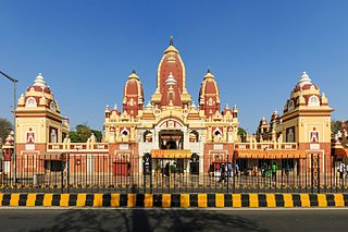
Chandni Chowk, New Delhi, DL Phone : 011 2336 5358
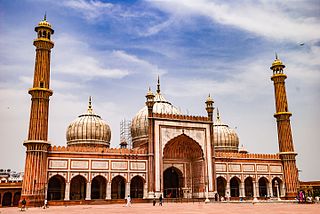
The Masjid-i Jahān-Numā, the ‘World-reflecting Mosque’, commonly known as the Jama Masjid Delhi, is one of the largest mosques in India.
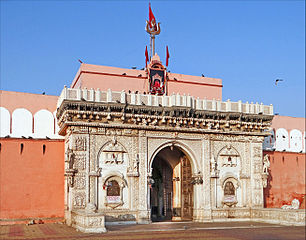
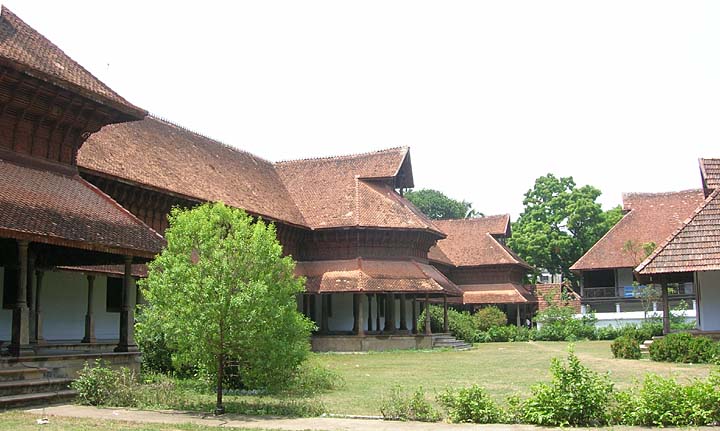
It was built by Mughal emperor Shah Jahan between 1644 and 1656 at a cost of 1 million rupees, and was inaugurated by an imam from Bukhara, present-day Uzbekistan. The mosque was completed in 1656 AD with three great gates, four towers and two 40 m high minarets constructed of strips of red sandstone and white marble. The courtyard of Jama Masjid Delhi can accommodate more than 25,000 persons. There are three domes on the terrace which are surrounded by the two minarets. On the floor, a total of 899 black borders are marked for worshippers. The architectural plan of Badshahi Masjid, built by Shah Jahan’s son Aurangazeb at Lahore, Pakistan, is similar to the Jama Masjid.
The mosque has three great gates, four towers and two 40 m high minarets constructed of strips of red sandstone and white marble. The northern gate has 39 steps and the southern side has 33 steps. The eastern gate was the rural entrance and it has 35 steps. Out of all these gateways, the eastern one, which was used by the emperors, remains closed during weekdays. The mosque is built on a red sandstone porch, which is about 30 feet (9.1 m) from ground level and spreads over 1200 square metre. The dome is flanked by two lofty minarets which are 130 feet (40 m) high and consists of 130 steps, longitudinally striped by marble and red sandstone. The minarets of Jama Masji Delhi consists of five storeys, each with a protruding balcony. The adjoining edifices are filled with calligraphy. The first three storeys of the minarets is made of red sandstone, the fourth of marble and the fifth of sandstone.
The courtyard Jama Masjid Delhi occupies 408 square feet. The mosque is about 261 feet (80 m) long and 90 feet (27 m) wide. The prayer hall measures 61 metre in length and 27.5 metre in breadth. It is made up of high cusped arches and marble domes. The cabinet located in the north gate has a collection of relics of Muhammad – the Quran written on deerskin, a red beard-hair of the prophet, his sandals and his footprints implanted in a marble block.
The floor plan of the mosque is similar to that of the Jama Masjid of Agra. It is covered with white and black ornamented marble to look like a Muslim prayer mat. Beside it, a thin black border measuring 3 feet (0.91 m) long and 1.5 feet (0.46 m) wide is marked for the worshippers. There are 899 total such boxes.
Location : It stands across the road from Red Fort
Visiting hours : All the days of the week, 7.00 AM to 12.00 PM and from 1.30 PM to 6.00PM
Entrance fee : Free
Don’t Miss : Tasting the Famous Non Vegetarian Cuisine of Karim’s, Especially the Mughlai Cuisine near the Mosque.
Must Enter : Through Eastern Gateway once used by the Mughal Kings to Offer their Prayers.Opened on Saturday – Sundays.
Must See : The Footwear – Red Beard Hair and the Foot Impressions of Prophet, the Replica of Quran (Holy Books of Muslims) Written on a Deer Skin kept inside the Mosque.
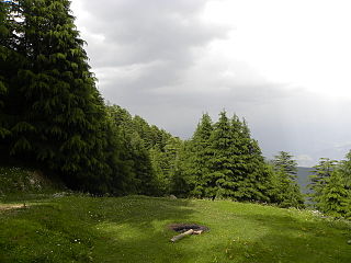
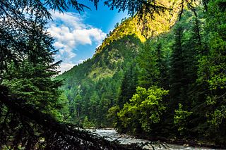
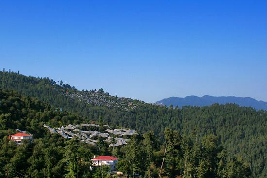
The picturesque Janjehli is situated at an elevation of 2150m. A lush green valley with agricultural fields in gentle slopes, apple orchards, hills covered with pine and deodar trees and a small river having crystal clear water moving like a snake through various criss-crossed hills Janjehli along with adjoining Keolidhar,Bagsaid valleys are a gift of nature to this district. It is loved by trekker and nature lover alike. The valley adorned by snow during winters, is no less than heaven on the earth. The art lovers must have glimpses of traditional wood carving and metal work. Visit to Janjehli is not complete without having blessing of Shikari Mata. Budha Kedar : Situated at an altitude of 9000 feet Budha Kedar can be visited by trekking a distance of 4 kms from HPTDC Trekker’s Hostel at Kataroo near Janjehli. The place is endowed with natural beauty. Deodar trees, streams of crystal clear water attract the tourists. The traditions have it that during exile Pandavas came here and saw Nandi at this place. Nandi jumped on a rock to save itself from Bhima of Mahabharata and disappeared through the rock. The hole has the shape of the back of the bull. People worship at this place and take holy bath in the nearby stream. Panday Shila (Rock) : situated just 3 kms ahead of the village on the bank of Bhekhli Khad in village Dhar Jarol Pandav Shila is believed to be of Mahabharata era. People believe that a pebble thrown on the rock stays on it their wishes are fulfilled. It is also said that a person with true belief can have slight movement by hand push on the top of the rock.
How to Reach:
Mandi – Pandoh, Bada Kanda Janjehli 76 kms and Sunder Nagar Dadur-Chailchowk-Janjehli 80kms.
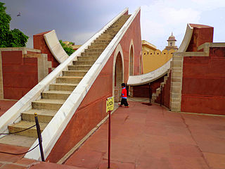
The Jantar Mantar Jaipur monument is a collection of nineteen architectural astronomical instruments, built by the Rajput king Sawai Jai Singh, and completed in 1738 . It features the world’s largest stone sundial.
Located near City Palace and Hawa Mahal of Jaipur, the monument features masonry, stone and brass instruments that were built using astronomy and instrument design principles of ancient Hindu Sanskrit texts. The instruments allow the observation of astronomical positions with the naked eye. The monument expresses architectural innovations, as well as the coming together of ideas from different religious and social beliefs in 18th century India. The observatory is an example of the Ptolemaic positional astronomy which was shared by many civilizations.
The Jantar Mantar Jaipur monument features instruments operating in each of the three main classical celestial coordinate systems: the horizon-zenith local system, the equatorial system and the ecliptic system. The Kapala Yantraprakara is one that works in two systems and allows transformation of the coordinates directly from one system to the other.
The observatory consists of nineteen instruments for measuring time, predicting eclipses, tracking location of major stars as the earth orbits around the sun, ascertaining the declinations of planets, and determining the celestial altitudes and related ephemerides.
Sansad Marg, Connaught Place, New Delhi, Delhi 110001
Phone : 011 2336 5358
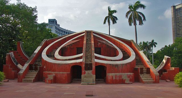
The Jantar Mantar is located in the modern city of New Delhi. It consists of 13 architectural astronomy instruments. The site is one of five built by Maharaja Jai Singh II of jaipur , from 1724 onwards, as he was given by Mughal emperor Muhammad shah the task of revising the calendar and astronomical tables. There is a plaque fixed on one of the structures in the Jantar Mantar observatory in New Delhi that was placed there in 1910 mistakenly dating the construction of the complex to the year 1710. Later research, though, suggests 1724 as the actual year of construction.
The primary purpose of the observatory was to compile astronomical tables, and to predict the times and movements of the sun, moon and planets. Some of these purposes nowadays would be classified as astronomy.
There are three instruments within the observatory of Jantar Mantar in New Delhi: the Samrat Yantra, the Jayaprakash, and the Misra Yantra.
Samrat Yantra: The Samrat Yantra, or Supreme Instrument, is a giant triangle that is basically an equal hour sundial. It is 70 feet high, 114 feet long at the base, and 10 feet thick. It has a 128-foot-long (39 m) hypotenuse that is parallel to the Earth’s axis and points toward the North Pole. On either side of the triangle is a quadrant with graduations indicating hours, minutes, and seconds. At the time of the Samrat Yantra’s construction, sundials already existed, but the Samrat Yantra turned the basic sundial into a precision tool for measuring declination and other related coordinates of various heavenly bodies.
Jayaprakash Yantra: The Jayaprakash consists of hollowed out hemispheres with markings on their concave surfaces. Crosswires were stretched between points on their rim. From inside the Ram, an observer could align the position of a star with various markings or a window’s edge.
Misra Yantra: The Misra Yantra was designed as a tool to determine the shortest and longest days of the year. It could also be used to indicate the exact moment of noon in various cities and locations regardless of their distance from Delhi – quite remarkable! The Mishra yantras were able to indicate when it was noon in various cities all over the world and was the only structure in the observatory not invented by Jai Singh II.
Address: R. Jardim Botanico, 1008 – Jardim Botanico, Rio de Janeiro – RJ, 22460-030, Brazi
Contact Number: +55-2138741808
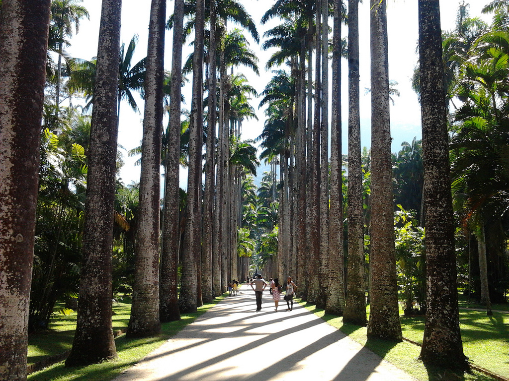
Jardim Botânico (English: Botanical Garden) is a wealthy residential neighborhood of Rio de Janeiro, Brazil, located north of Ipanema and Leblon, just across Lagoa Rodrigo de Freitas and east of Gávea. Jardim Botânico lies in the South Zone of Rio de Janeiro.
The district got its name as it grew around the city’s Botanical Garden. The residents are generally upper-middle to upper-class and do not live near a favela, which is rare in the city. It differs from most of Rio’s neighbourhoods due to the large number of large detached houses, again not that common in the densely populated south zone. It is home to many Brazilian celebrities and the headquarters of the nationwide television network, Rede Globo. Many of Rede Globo’s studios are in the neighbourhood.
The main road in the borough is the Rua Jardim Botanico (Jardim Botanico Street). The neighborhood leads to Rio de Janeiro’s large Tijuca Forest, using a road that winds up through the mountainous forest.
One of Rio de Janeiro’s most famous carnival blocs parades annually through the streets of Jardim Botanico. The bloc calls itself “Suvaco do Cristo”, which translates to “Armpit of the Christ” because Jardim Botânico lies underneath the right armpit of Rio de Janeiro’s most prominent landmark, Cristo Redentor (Christ the Redeemer) statue.
Source : wikipedia https://www.youtube.com/watch?v=j6LMPnbJbf0 https://www.youtube.com/watch?v=88F6wf8CTs4 Reviews https://bit.ly/3a18nZU Visiting hours : 08.00AM to 05.00 PM Entry : Adults R$15,00 (Cash only!)
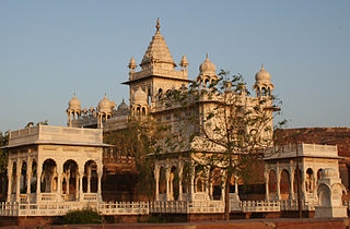
The Jaswant Thada is a cenotaph located in Jodhpur. It was built by Maharaja Sardar Singh of Jodhpur State in 1899 in memory of his father, Maharaja Jaswant Singh II, and serves as the burial ground for the rulers of Marwar.
The mausoleum is built out of intricately carved sheets of marble. These sheets are extremely thin and polished so that they emit a warm glow when illuminated by the sun.
The cenotaph’s grounds feature carved gazebos, a tiered garden, and a small lake. There are three other cenotaphs in the grounds. The cenotaph of Maharaja Jaswant Singh displays portraits of the rulers and Maharajas of Jodhpur.
You can visit Mehrangarh Fort along with Jaswant Thada as both are located in same road and Jaswant Thada is towards right ( while going to fort ) at a distance of 1 KM.
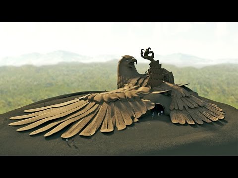
Image Credit : youtube,comRavana cuts Jatayu’s wings, by Raja Ravi Varma
Jatayu Nature Park is a park and tourism centre under construction at Chadayamangalam in Kollam district of Kerala. Designed by Rajiv Anchal, This rock-theme nature park is about 38 km (24 mi) away from Kollam and 46 km (29 mi) away from the state capital, Thiruvananthapuram. It is the first PPP tourism initiative in the state of Kerala under the BOT model. When open, Jatayu Nature Park will hold the distinction of having the world’s largest bird sculpture (200 feet (61 m) long, 150 feet (46 m) broad, 70 feet (21 m) in height and having 15,000 square feet (1,400 m2) of floor area) of the great mythical bird Jatayu.
The park
The ₹100 crore (US$15 million) worth initial phase of Jatayu Nature Park is expected to open in the first quarter of 2017 with an adventure zone having 3 km (1.9 mi) radius.[4][5] On 29 November 2015, Dubai Corporation for Tourism and Commerce’s Director of stakeholder relations, Majid Al Marri visited the under construction Jatayu Nature Park along with the Chief Minister of Kerala, Mr. Oommen Chandy and he got amazed by the project.
Etymology
The Jatayu Nature Park is under construction at Chadayamangalam (Jatayumangalam) town. The town got this name in connection with Jatayu, the demi-god in Hindu mythology, who has the form of an Eagle.
As per Hindu mythology, Ravana abducted Sita to Lanka. Jatayu had tried to rescue Sita from Ravana when Ravana is on his way to Lanka. Jatayu fought valiantly with Ravana, but as Jatayu was very old Ravana soon got the better of him. As Rama and Lakshmana chanced upon the stricken and dying Jatayu in their search for Sita, he informs them of the fight between him and Ravana and tells them that he had gone south. It is believed that Jatayu fell on the rocks in Chadayamangalam after his wings were chopped off by Ravana.
Facilities
6D theatre
Cable car
Digital Museum
Adventure zone (with 20 games)
Facility for Bird’s eye view
Ayurvedic and Siddha cave resort
Jatoli Shiva Temple is a beautiful Temple dedicated to Lord Shiva and according to official site of Solan district it is the tallest Shiv Temple of Asia.
Jatoli Shiv Temple is one of the famous holy destinations of Solan which attract a large number of pilgrims and is only 6 Kms from the city. The temple is made in typical Southern-Dravidian style architecture and is made of three consecutive pyramids. On the first pyramid, one can see the image of Lord Ganesha while on second pyramid there is a sculpture of Shesh Naag. There is a water pond near the temple which is believed to have divine powers.
This Temple is built by initiative of a sage way back in eighties who used to meditate here .
The cave in which he meditated is still there besides very nicely built other adjoining buildings. https://www.youtube.com/watch?v=fqHW5wjdgpU
Click On The URL Or PICTURE for the complete News, Videos and more photos.
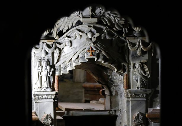
Researchers have continued their investigation into the site where the body of Jesus Christ is traditionally believed to have been buried, and their preliminary findings appear to confirm that portions of the Jesus christ’s tomb are still present today, having survived centuries of damage, destruction, and reconstruction of the surrounding Church of the Holy Sepulchre in Jerusalem’s Old City.
The most venerated site in the Christian world, the Jesus christ’s tomb today consists of a limestone shelf or burial bed that was hewn from the wall of a cave. Since at least 1555, and most likely centuries earlier, the burial bed has been covered in marble cladding, allegedly to prevent eager pilgrims from removing bits of the original rock as souvenirs.
When the marble cladding was first removed on the night of October 26, an initial inspection by the conservation team from the National Technical University of Athens showed only a layer of fill material underneath. However, as researchers continued their nonstop work over the course of 60 hours, another marble slab with a cross carved into its surface was exposed. By the night of October 28, just hours before the tomb was to be resealed, the original limestone burial bed was revealed intact.
“I’m absolutely amazed. My knees are shaking a little bit because I wasn’t expecting this,” said Fredrik Hiebert, National Geographic’s archaeologist-in-residence. “We can’t say 100 percent, but it appears to be visible proof that the location of the tomb has not shifted through time, something that scientists and historians have wondered for decades.”
In addition, researchers confirmed the existence of the original limestone cave walls within the 18th-century Edicule, or shrine, which encloses the tomb. A window has been cut into the southern interior wall of the shrine to expose one of the cave walls.”This is the Holy Rock that has been revered for centuries, but only now can actually be seen,” said Chief Scientific Supervisor Professor Antonia Moropoulou, who is directing the conservation and restoration of the Edicule.
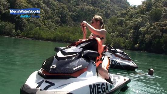
How in the world can you grasp the beauty of all these islands when you only have a few days to visit? An island Jet Ski Tour! Easily the fastest (and most fun!) way to see the islands is to zip around on a jet-ski. There is no other perfect combination! Sun, sea, sand, and fun!
It was a beautiful morning as we arrived at the beach for our Jet Ski Tour. The days can get hot so it was a good idea to get going before the heat of the day! The ocean is a lot calmer in the morning too, so we were feeling pretty excited to tear it up on the jet skis! Right on the beach is a wooden hut where they offer the Jet Ski Tour. Look for Mega Water Sports and you’ll find they have a great selection of Jet Ski Tour. We booked the Dayang Bunting Island Tour – a 4 hour tour visiting 8 islands!
We were a group of 6 jet skis plus our guide. We learned all about the “V” formation we were to drive in to prevent crashes and to allow us to drive faster. There was a lot of water to cover and islands to explore! Our tour included a visit to 8 of the islands, cave formations, swimming in the open water among the limestone cliffs, snorkeling, and a stop at the UNESCO Geopark where there’s a freshwater lake!
After getting to our first stop with the jet skis we jumped in the water to cool off – it was hot out! Here we could yell and hear our echo! So cool! The limestone cliffs are mesmerizing! We could only imagine all the caves that are still undiscovered on those sheer cliffs!
Next we went into cruise mode and slowly navigated our way underneath the cliff overhangs. The water was crystal clear and we could see lots of colorful fish swimming around. We were crossing our fingers that none of the rocks were deciding to fall that day! It’s absolutely stunning to be able to drive under these HUGE cliffs!
At one point, the guide informed us we were going to navigate through a cave. It’s only possible when the tide is low and we were lucky to go right through! It was tricky to keep the jet ski straight and not hit the walls! We made it through without a scratch but a few in our group got nervous and couldn’t keep the jet ski straight and kept bumping into the rock walls!
Source : unevensidewalks.com/
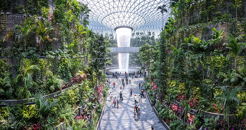
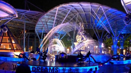
Jewel Changi Airport (also known as Jewel or Jewel Changi) is a nature-themed entertainment and retail complex on the inside of Changi Airport, Singapore, linked to three of its passenger terminals. Its centrepiece is the world’s tallest indoor waterfall, the Rain Vortex, which is surrounded by a terraced forest setting.
Jewel includes gardens, attractions, a hotel, about 300 retail and dining outlets, as well as early baggage check-in aviation facilities. It covers a total gross floor area of 135,700 m2 (1,461,000 sq ft), spanning 10 storeys – five above-ground and five basement levels.[6] Its attractions include the Shiseido Forest Valley, an indoor garden spanning five storeys, and the Canopy Park at the topmost level, featuring gardens and leisure facilities.
Jewel receives about 300,000 visitations a day. In October 2019, six months after its soft opening, it had welcomed 50 million visitors, exceeding its initial target for whole year. The complex and airport is located in Changi, at the eastern end of Singapore, approximately 20 km (12 mi) northeast from Singapore’s Downtown Core. https://www.youtube.com/watch?v=sYc9jDuRN4w https://www.youtube.com/watch?v=G6-tFi2mXf4
Attractions
Shiseido Forest Valley
Image Credit : Tripadvisor
A collaboration of Shiseido and art collective teamLab, the Shiseido Forest Valley is one of Asia’s largest indoor gardens, spanning five stories and approximately 22,000 square metres (240,000 sq ft) located in the heart of Jewel Changi Airport. It houses around 3,000 trees and 60,000 shrubs of 120 species that live in high-altitude tropical forests from around the world. https://www.youtube.com/watch?v=eMnFP5sUXpM https://www.youtube.com/watch?v=BSTIwaYj1nY
Entry and exit points are present at every level. It is linked to the arrival hall in Terminal 1 and the pedestrian walkway in Terminal 2 and 3. Practical Information
Allow half an hour for each trail, at a comfortable pace with ample time for photo-taking. There are several exit points and seats along the way.
Luggage and wheeled bags are not allowed, but can be left at our baggage storage.
– Suitable for all ages
– High heels not recommended
The Rain Vortex
Image Credit : jewelchamgiairport.com
The Rain Vortex, sponsored as the HSBC Rain Vortex, is the world’s largest and tallest indoor waterfall, standing at 40 metres (130 ft) high. Recirculating rain water is pumped to the roof to free fall through a round hole at up to 37,850 liters (8,330 imp gal; 10,000 U.S. gal) per minute to a basement-level pool. An acrylic funnel at the bottom prevents splashing and insulates the sound of the cascade. The toroid-shaped roof has more than 9,000 pieces of glass spanning 200 by 150 meters (660 by 490 ft) with a sloped oculus as the mouth of the waterfall acting as “a continuation of the building…completed in a liquid form.” At night, the circular walls of the waterfall becomes a 360-degree stage for a light-and-sound show.
To prevent excess humidity in the Jewel, the waterfall’s flow alternates between cascades and trickles that reduce air turbulence. The design process by WET Design engineers included testing a one-fifth-scale model and a full-size partial prototype.
Reviews https://bit.ly/32PbOQd
OPENING HOURS
Mon – Fri: 11:00AM – 10:00PM
Sat – Sun, including PH: 10:00AM – 10:00PM
The Jewel HSBC Rain Vortex Light Show takes place at an hourly interval in the evening. The Jewel light show times are 7.30 pm, 8.30 pm, 9.30 pm, 10.30 pm and 11.30 pm.
Canopy Park
Image Credit : commons.wikimedia.org
At the topmost level of Jewel, the 14,000 square metres (150,000 sq ft) Canopy Park houses recreation and leisure attractions. About half of the total landscaping is hosted at Canopy Park, including two gardens: Topiary Walk and Petal Garden. The Topiary Walk features animal-shaped topiaries at every corner, while the Petal Garden has seasonal floral displays.The park includes a suspension bridge called the Canopy Bridge that is located 23 metres (75 ft) above the ground which offers a panoramic view of the Rain Vortex. At 50 metres (160 ft) long, the Canopy Bridge also has a glass panel flooring at the centre section that offers a view through to level 1 of Jewel.
The park also consists of two mazes, situated at the eastern end of the Jewel called the Hedge Maze and Mirror Maze.The Hedge Maze is Singapore’s largest with hedge walls standing at 1.8 metres (5 ft 11 in) high. The maze features gates that can be pushed within that will change the path of the maze. It ends at an elevated watchtower that offers a bird’s-eye view of the entire maze. The Mirror Maze is located under the dome with plants branching across the top of the maze. The maze makes use of mirrors and various reflections. https://www.youtube.com/watch?v=jxSlQVFe-Yk https://www.youtube.com/watch?v=APmZ-U6qOY0
The Sky Nets, also called the Manulife Sky Nets for sponsorship reasons, provide children’s play facilities, including a Bouncing Net and a Walking Net. The Bouncing Net is 250 metres (820 ft) long, suspended 8 metres above ground at its highest point. A separate 50 metres (160 ft) long Walking Net enables visitors to look down 25 metres (82 ft)s to Jewel’s Level 1. https://www.youtube.com/watch?v=8LRJzi2un28 https://www.youtube.com/watch?v=YWH6F8BXZNg
The Discovery Slides feature four integrated slides: two tube slides and two sliding surfaces.The entire structure sits at an incline, 3 metres (9.8 ft) high on one end, and close to 7 metres (23 ft) on the other, and enables visitors to view the Forest Valley and the Rain Vortex.The Discovery Slides were designed by Carve and built by Playpoint in Singapore. https://www.youtube.com/watch?v=fPGu1ZGAW80 https://www.youtube.com/watch?v=tDIF1H9oDBM
Aviation facilities
An ‘integrated multi-modal transport lounge’ provides ticketing, boarding pass collection and baggage transfer service in a single location. Early check-in facilities enable passengers to check-in and drop off luggage up to 24-hours ahead of regular check-in times. There are dedicated facilities for fly-cruise and fly-ferry passengers.
Retail
Jewel houses both local and international brands. Anchor tenants include the largest Nike store in Southeast Asia, the first and only Apple Store located inside an airport complex, Marks & Spencer, Muji, Zara, Uniqlo, Singapore’s second basement cinema operated by Shaw Theatres with 11 screens including an IMAX theatre with a seating capacity of 828 and Five Spice, a food court by Food Junction with 19 unique stalls and supermarket chain FairPrice Finest.
Jewel also includes American burger chains A&W Restaurants and Shake Shack, Norwegian fast-casual restaurant Pink Fish, Swiss artisanal chocolatier Läderach, Sichuan restaurants Xiao Bin Lou and Yu’s Kitchen, Boston-based ice cream parlour chain Emack & Bolio’s, British casual eatery Burger & Lobster, Peruvian restaurant TONITO, Japan’s Tokyo Milk Cheese Factory and the first permanent Pokémon Centre in East Asia outside of Japan.
Source: Wikipedia
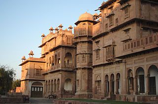
Junagarh Fort is a fort in the city of Bikaner. The fort was originally called Chintamani and was renamed Junagarh or “Old Fort” in the early 20th century when the ruling family moved to Lalgarh Palace outside the fort limits. It is one of the few major forts in Rajasthan which is not built on a hilltop. The modern city of Bikaner has developed around the fort.
The fort complex was built under the supervision of Karan Chand, the Prime Minister of Raja Rai Singh, the sixth ruler of Bikaner, who ruled from 1571 to 1611 AD. Construction of the walls and associated moat commenced in 1589 and was completed in 1594. It was built outside the original fort of the city, about 1.5 kilometres (0.93 mi) from the city centre. Some remnants of the old fort are preserved near the Lakshmi Narayan temple.
Historical records reveal that despite the repeated attacks by enemies to capture the fort, it was not taken, except for a lone one-day occupation by Kamran Mirza. Kamran was the second son of the Mughal Emperor Babur who attacked Bikaner in 1534, which was then ruled by Rao Jait Singh. In the battle, the Mughals were defeated by Rathors. Kamran then returned to Lahore.
The 5.28 hectares large fort precinct is studded with palaces, temples and pavilions. These buildings depict a composite culture, manifest in the mix of architectural styles.
Structures
Left: Views of palaces from the main courtyard built in Italian Carrara marble, Right: Karan Mahal and pond in the main courtyard, in Mughal style of architecture
The structures built within the Junagarh fort are the palaces and temples, which are made of red sandstone (Dulmera) and marble. The palaces are described as picturesque with their assortment of courtyards, balconies, kiosks and windows. The fort, the temples and the palaces are preserved as museums and provide insight into the grandiose living style of the past Maharanas of Rajasthan. The fort is called “a paradox between medieval military architecture and beautiful interior decoration”
Temples Har Mandir temple was the royal chapel – private temple of the royal family. The royal family celebrated the Hindu festival of Dussera and Gangaur here, apart from celebrating other family functions such as birthdays and marriages. In the Dussera celebrations, weapons and horses were worshipped here. The main deities worshipped in this temple are the Hindu deities Lakshmi Narayan, a combined representation of god Vishnu and his consort Lakshmi.
The Ratan Behari temple located near the Junagarh Fort, was built in 1846 by the 18th ruler of Bikaner. It was built in Indo-Mughal architectural style using white marble. The Hindu god Krishna is deified in this temple.
Palaces Karan mahal (Public Audience Hall) was built by Karan Singh in c.1680 to mark his victory over the Mughal Emperor Aurangzeb. It is considered as one of the most exquisite palaces built with gardens, which displays the aesthetic sensibilities of the royalty of Rajasthan. It has stained glass windows and intricately carved balconies built in stone and wood fluted columns. Later Rajas, Anup Singh and Surat Singh, also added lot of glitter to this palace with inlaid polychrome glass, intricate mirror patterns, and red and gold paint. In the coronation chamber, there is a shored up alcove, which was used as a throne. Phool Mahal (“Flower Palace”) is the oldest part of the palace and was built by king Raja Rai Singh of Bikaner, who ruled between 1571-1668. Anup Mahal is a multi-storey structure, which functioned as the administrative headquarters of the kingdom. It has ornate wooden ceilings with inlaid mirrors, Italian tiles, and fine lattice windows and balconies. It has some gold leaf paintings. It is considered as one of the “grandest construction”. Chandra Mahal has the most luxurious room in the palace, which houses gold plated deities and paintings inlaid with precious stones. In the royal bedroom, mirrors have been strategically placed so that the Maharaja could see from his bed, any intruder entering his room. Ganga Mahal was built in the 20th century by Ganga Singh who reigned for 56 years from 1887 to 1943, has a large durbar hall known as the Ganga Singh Hall that houses the Museum. The museum has exhibits of war weaponry and also a World War I aeroplane (biplane), which is stated to be well maintained. Badal Mahal (The weather palace) is part of the Anup Mahal extensions. It has paintings of Shekhawati Dundlod chiefs paying respects to the Maharaja of Bikaner in different types of turbans. Photos of people standing on nails, wood, swords and saws are also depicted here – a display of faith and endurance. The walls in this palace depict fresco paintings of the Hindu god Krishna and his consort Radha amidst the rain clouds.
Bikaneri Havelies located both within and outside the fort in the Bikaner city’s by lanes are also of unique architectural style in home architecture. Aldous Huxley who visited these havelis reportedly said “They are the pride of Bikaner.”
Fort museum
The museum within the fort called the Junagarh Fort Museum was established in 1961 by Maharaja Dr.Karni Singhji under the control of “Maharaja Rai Singhji Trust”. The Museum exhibits Sanskrit and Persian manuscripts, miniature paintings, jewels, royal costumes, farmans (royal orders), portrait galleries, costumes, headgear and dresses of gods’ idols, enamelware, silver, palanquins, howdahs and war drums. The museum also displays armoury that consists of one of the assorted collection of post medieval arms.
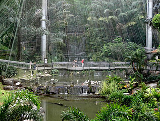
Jurong Bird Park is an aviary and tourist attraction in Jurong, Singapore. It is now a world-famous bird zoo where there are specimens of magnificent bird life from around the world, including a large flock of flamingos. It is currently the world’s largest bird park in terms of the number of birds, and second largest both in the number of bird species and land area (after Germany’s Weltvogeipark Walsrode). There are 5,000 birds of 400 species in Jurong Bird Park, of which 29 are of threatened species.
Exhibits
African Waterfall Aviary
The African Waterfall Aviary is the second largest walk-in aviary in the world, covering 2 hectares (4.9 acres) and including more than 600 free-flying birds of more than 50 species. The aviary is named after the 30-metre (98 ft) tall Jurong Falls, one of the world’s tallest man-made waterfalls. Species include the golden-breasted starling, turacos and the hoopoe.
Dinosaur Descendants
In one corner of the zoo there is a section full of flightless birds: ostriches, emus, rheas and cassowaries are the residents of this exhibit.
Southeast Asian Birds Aviary
Visitors can see the largest collection of Southeast Asian birds, which has over 200 species. There are large, central walk-in aviaries and peripheral aviaries housing the more delicate and territorial birds. A thunderstorm is simulated at noon each day, followed by a cool, light drizzle. Territorial species are kept in large cages, while species that can coexist with each other (fruit doves and pigeons being two examples) are left to roam freely in the aviary.
Lory Loft
About nine storeys high and covering 3,000 square metres (32,000 sq ft), the Lory Loft is the world’s largest walk-in flight aviary for lories and lorikeets, with over 1,000 free-flying lories. The ambience is similar to that of a rainforest valley in tropical Northern Australia . Visitors can offer the lories a special nectar mix.
Penguin Coast
Houses five species of penguins within 1,600 square metres (17,000 sq ft). Featuring a 21-metre (69 ft) tall Portuguese galleon façade and designed to resemble a ship, the interior of Penguin Coast is constructed with timber beams and wooden flooring. Penguin Coast is home to the Humboldt, rockhopper, macaroni and king penguins, which live in an indoor, climate-controlled den with access to an outdoor enclosure showcasing African penguins, one of the few species that are adapted to the tropics. Joining them are cape shelducks and gulls.
World of Darkness
Asia’s first nocturnal bird house features a system of reverse lighting, converting day to night and vice versa. On display are 60 birds from 17 species, like the night herons, fish owls, boobook owls and snowy owls. It is akin to a quiet nocturnal walk along a starlit jungle path, watching birds in their nocturnal surroundings and hearing them beckon each other.
Pelican Cove
Visitors catch a glimpse of all seven species of pelicans, including the endangered Dalmation Pelican. There is a board-walk where visitors can stroll and observe the birds. Visitors can also see the pelicans at the world’s first underwater viewing gallery for pelicans, where the birds scoop up fish at feeding time.
Shows
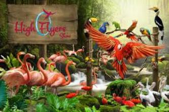
High Flyers Show
This bird show has the world’s largest number of performing birds in a single act. Besides highlighting the antics of talented birds like the mimicking cockatoos, this show is also a window onto the natural behaviour of birds like pelicans, flamingos and hornbills.
Kings of the Skies Show
Visitors watch birds of prey such as eagles, hawks and falcons, who will fly in loops and soar above the treetops. Visitors also learn about falconry as these birds are put through their paces in a simulated hunt.
Lunch with the Parrots
Visitors enjoy a parrot show over lunch in front of the flamingo lake.
Kalatop Khajjiar Sanctuary is a 30.69 km² animal sanctuary at Kalatop and Khajjiar in the Chamba district of Himachal Pradesh, India. The sanctuary area is well laid out for trekking trails both at Kalatop and Khajjiar. There is a dense deodar and fir forest covering 19.63 km² of the sanctuary, which is about 6 km from Dalhousie. Pheasants, serow and black bear are some of the common animals found here. The sanctuary lies in the path of the Ravi River, and is surrounded by coniferous and oak forests.
Flora and fauna
The vegetation consists of blue pine and deodar forest, with oak. Undergrowth in the forest area is well developed.
Mammals- bear, Himalayan Black Marten, leopard, deer, Barking Goral, squirrel, serow, jackal, langur.
Birds- Blackbird
Birds in this sanctuary many Birds are found some of them are listed below:- 1. Eurasian Jay 2. Whitewinged Black Bird 3. Black Headed Jay 4. Chesnut Billed Rock Thrush 5. Blackheaded Jay. 6. Grey Headed Cannery Flycatcher.
Source : Wikipedia
The Kalatop Khajjiar Sanctuary spreads over the deodar forests that horde the slopes between Khajjiar and Dalhousie in Himachal Pradesh.The Kalatop Sanctuary is one of the most popular place and identifyby the wildlife sanctuaries in Himachal Pradesh and stretches over 1962 hectares.It falls under the jurisdiction of the Chamba.
The temple is situated near to The Mall and its 5 minutes walk from The Mall.The temple is dedicated to Shyamala Devi (Shimla is named after this goddess), an incarnation of Goddess Kali. Temple faces heavy rush during Diwali and Durga Puja as many Bengalis visit this temple.
Source: hpshimla.nic.in
The famous Kalibari Temple of Shimla is a popular tourist attraction and is situated at a very strategic location. The temple was built in the year 1845 and is dedicated to Goddess Kali who is also known as Shyamala. It is from the name of Goddess Shyamala that Shimla derives its name. The Kali Bari temple of Simla is a very well known religious place of India and people who come to Shimla never miss out on visiting this temple. The Kalibari temple was primarily located in Jakhu hill. The British brought it to its new site.
Kali Bari Temple is a temple dedicated to the Hindu goddess Shyamala, from which the hill station-and capital of Himachal Pradesh, Shimla derives its name.Kali Bari Temple houses a shrine of the Hindu goddess Shyamala. Shyamala has multiple aliases, including Kali and Durga.
Source : simlakalibari.org
Kali Devi is the main deity of Kali ka Tibba located on top of a mountain at an altitude of 7500 ft. in Chail. The deity is also regarded as the goddess of time and change. Beautiful scenery of the Shivalik Range and the Choor Chandni peak are breathtaking from the temple.
Chail at an altitude of 2,250 meters is at a higher altitude than Shimla which is 2,213 meters above sea level. Shimla and Kasauli can be seen from Chail. Kali ka Tibba is an ideal destination for those who are looking for a secluded destination away from tourist crowds. The best time to visit this place is in monsoons between August and November as the thick forest cover around the temple gets green and pretty.
Situated en route to the popular hill station of Ponmudi, Kallar gets its name from the River Kallar, which flows through the region. Kallu means ‘stone’ and Aru means ‘river’, hence the name Kallar. The river is well known for its abundance of attractive, round-shaped boulders and pebbles, especially in the upper reaches and middle portion of its course.
It is about 50 km from the capital city of Thiruvananthapuram, and is an idyllic location. It is a favourite haunt for picnickers and attracts many with an interest in trekking, angling and bird watching.
Here, the main attractions are the nearby Golden Valley, and the Meenmutti waterfall. Unlike the Meenmutti waterfall, the Golden Valley is easily accessible form the main road. Here one can take a dip in the crystal clear waters to cool off, and also watch the many rapids and small pools that dot a good part of the river in this area.
Apart from Golden Valley, those with a zeal for trekking and birdwatching can take a narrow track, starting from the right side of the Kallar Bridge. The track will lead one to a medium sized, but captivating waterfall, popularly known as Meenmutty. The waterfall is situated 3-4 km from the main road. On the way to the waterfall, one would come across ample bird life, and many species of butterflies. The forest here is mostly tropical in nature, and during the rainy season, one has to be on the alert for leeches. Assistance from the Kallar Vana Samrakshana Samithi (Kallar Forest Protection Group) is available for trekking and also for hiring guides. The group is a joint venture by the State Department of Forest and the local community.
Probably one of the most beautiful and greatest heritage preserves in Kerala, Kalpathy Heritage Village and Temple Complex is situated very close to Palakkad town. The cultural heritage of the place will take you back in time, most accurately of Brahmin culture. You can catch a glimpse of the traditions that passed down generations, probably over thousands of years and still going strong. Kolam (Designs made with rice batter, outside each household to welcome Goddess), priests chanting slogans in sanskrit, the women of the village clad in their traditional saree are all proof that the village remains as it was. Though there are Tamil Brahmins all over Kerala, Palakkad is considered as the epicenter for them and so this village is exclusively dedicated to them.
The agraharams (Brahmin community streets) were established by migrant brahmins from Tamil Nadu. The important temple for the site will be one Viswanatha Swamy temple, constructed in the early 16th Century. Also to see here are many sub temples like Vinayagar, Subramaniar, Kala Bhairavar. The famous activity here is the Kalpathy chariot festival (Ratholsavam). The entire city of Palakkad conglomerates here during that time. Folklore and astounding way of life here adds more charm to this tiny village. Furthermore, architectural changes are prohibited here and so it is the raw and original lifestyle of the people then.
Source : southindiatoursandtravels https://www.youtube.com/watch?v=HIxaefCiSTc https://www.youtube.com/watch?v=Q2JyfJo239U https://www.youtube.com/watch?v=L1WDuFhhHpQ Reviews https://bit.ly/3J1Keji
Kalpathy Heritage Village and Temple in Kalpathy in Palakkad district is famous for its unique architecture, culture and Rathotsavam (chariot festival)
Kalvari Mount, 12 kms. from Idukki also known as the Calvary Mount, lies in the vicinity of Thekkady, on the way to Kattappana. The mountain provides beautiful views of the Idukki Reservoir as well as the two prominent tribal villages of the region, namely Kamakshy and Mariyapuram. Elephants can also be seen roaming in the forests, near the foothill.
Visitors have the option of trekking to the top from the Idukki and Kattapana main road, or they can cover part of the way, up to the ticket counter, by jeep.
The Malankara Dam, Idukki Hydroelectric Project and Nadukani and numerous tea gardens are present in its vicinity. https://www.youtube.com/watch?v=kKCBkXTVWsA https://www.youtube.com/watch?v=f-1ma1isqFo https://www.youtube.com/watch?v=_6am9v6HcyI https://www.youtube.com/watch?v=ItCKiz7mp3E Reviews https://goo.gl/TkPCEF
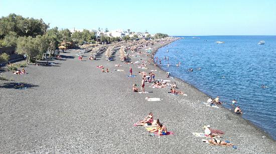
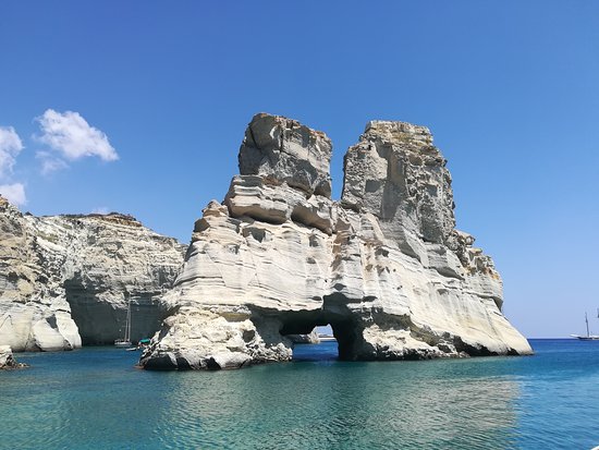
The villageKamara got its name from a small arch (Greek: Καμάρα, Kamara) that still rises at the south end of its beach and is what remains from an ancient sanctuary dedicated to Poseidon. Today, it stretches along a beach covered with black pebbles, which is the longest of the island. The beach extends in a northeast to southwest direction from Monolithos to the feet of the Mesa vouno mountain that rises up to a height of approx. 400m, being Santorini’s second highest peak. Once an agricultural and fishing village, modern Kamari boasts a thriving tourist industry, offering a wide choice of accommodation, restaurants, cafes, bars and night clubs, plus several water sport activities.
In 2002, an archaic sanctuary dedicated to Achilles was discovered in Kamari.
Source : Wikipedia https://www.youtube.com/watch?v=94OMOgF1y-E https://www.youtube.com/watch?v=YcxGHP50T4c Reviews https://bit.ly/3feTxf2
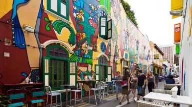
Discover Kampong Glam’s rich history, living traditions, excellent eateries and trendy shops in this vibrant neighbourhood.
Some say Kampong Glam really is glam (a local term meaning ‘glamorous’). The area has an eclectic blend of history, culture and a super-trendy lifestyle scene.
See if this is true on your Kampong Glam journey. Start from the landmark Sultan Mosque, and wander through the many side streets.
Kampong Glam has its origins as a fishing village at the mouth of Rochor River. The Malay word ‘kampung’ means ‘village’, and the area was known for the gelam tree (or Paperbark Tree) that grew here and was used for building ships.
In 1822, Sir Stamford Raffles allocated the area to the Malay Sultan Hussain Mohammed Shah and others in the Muslim community, including Arab and Bugis traders.
Today, the grounds of the ‘Istana’ (‘palace’) is home to the Malay Heritage centre, where you can get to know Malay history and culture better.
You’ll love the culinary delights here, from local delicacies such as nasi padang (steamed rice served with various dishes) and Malay kuih (‘cakes’) to Middle Eastern, Japanese, Swedish and even Mexican fare.
Shopaholics, head to colourful Haji Lane – a row of multi-label stores, quirky boutiques as well as hip bars and cafes. Or pick up traditional wares such as Persian carpets, kebaya dresses and handmade perfumes from Arab Street and Bussorah Street.
Kampong Glam truly comes alive during Ramadan (Muslim fasting month) leading up to Hari Raya Aidilfitri. Join in the ‘breaking of fast’ (iftar) in the evenings, or stroll through the bustling night markets.
Located about 800 meters north east of the Napier Museum in the heart of Trivandrum city, Kanakakunnu Palace is one of the last architectural vestiges of the colonial era. Built during the reign of Travancore king Sree Moolam Thirunal (1885−1924) with the help of Viswabrahmin, the palace served as the main venue for royal banquets. Later Swathi Thirunal, one of Travancore’s popular rulers, refurbished the palace and constructed tennis courts in the premises. He also did use it for a few years as a summer retreat. Boasting a Kerala style facade, the Travancore royal family used the house to entertain guests. Inside you will see massive crystal chandeliers and an array of exquisite pieces of royal furniture – a testimony to the lavish lifestyle of the Thirunal kings who had a penchant for music and art. Add to it a picturesque setting on the crest of a small hill lush with meadows, grooves and flowering shrubs.
Now under the Kerala government’s wing, the palace complex walls-in the Nishagandhi open-air auditorium and Sooryakanthi auditorium. A popular haunt of culture vultures in the city, the auditoriums are the venues for various cultural meets and programs. The prestigious All India Dance Festival aka Nishagandhi festival is hosted annually by the Department of Tourism at the Nishagandhi open-air auditorium. Indian classical dance exponents from across the country come down to participate in the festival.
The Kangra Fort is located 20 kilometers from the town of Dharamsala on the outskirts of the town of Kangra, India.
The entrance to the fort is through a small courtyard enclosed between two gates which were built during the Sikh period, as appears from an inscription over the entrance. From here a long and narrow passage leads up to the top of the fort, through the Ahani and Amiri Darwaza (gate), both attributed to Nawab Saif Ali Khan, the first Mughal Governor of Kangra. About 500 feet from the outer gate the passage turns round at a very sharp angle and passes through the Jehangiri Darwaza.
The Darsani Darwaza, which is now flanked by defaced statues of River Goddesses Ganga and Yamuna gave access to a courtyard, along the south side of which stood the shrines Lakshmi-Narayana Sitala and Ambika Devi. In between these shrines is a passage that leads up to the palace. It is one of the most beautiful forts in India.
The fort stands on a steep rock in Purana Kangra (translates to Old Kangra) dominating the surrounding valley, built strategically at the “sangam” confluence (places where two rivers meet) of Banganga and Majhi rivers. It is said that Kangra belongs to one who owns the fort.
Also near to old Kangra is the famous Jayanti Mata temple on a hill top. The Temple was built by the General of the Gorkha Army, Bada Kaji Amar Singh Thapa. Also close to entrance is a small museum which exhibits the history of Kangra fort.
Adjoining the Fort is the Maharaja Sansar Chand Katoch Museum run by the Royal Family of Kangra. The Museum also provides audio guides for the fort and the museum and has a cafeteria.
Nullatanni, Munnar, Kerala 685612
Phone: 04868 255 000
Image credit : wikipedia
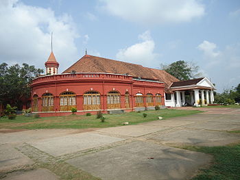
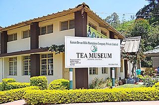
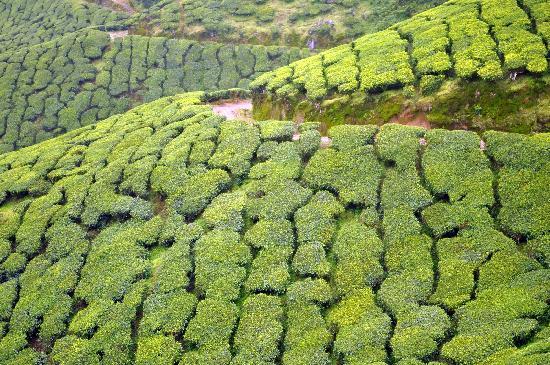
The Munnar Tea Museum is an industry and history museum situated in Munnar, a town in the Idukki district of Kerala in South India. Tata Tea Museum is its official name, but it’s also known as Nalluthanni Estate where it is located, or Kannan Devan Tea Museum.
History and points of interest
The tea estate is owned by Kanan Devan Hills Plantations Company (P) Ltd. (KDHP) – the plantation dates back to the 1880s. The museum opened on 1 April 2005. The tea museum preserves the aspects on the genesis and growth of tea plantations in Kerala’s mountain region in the Idukki district on the Western Ghats at the boarder to the Coimbatore district of Tamil Nadu. Tata Tea opened the museum which houses curiosities, photographs and machineries, depicting a turning point that contributed to Idukki’s flourishing tea industry. Set up at the Nallathanni Estate, the museum is a tribute to its pioneers who transformed Munnar into a major tea plantation centre of Kerala, from the rudimentary tea roller from 1905 to a fully automated tea factory. Visitors and tea lovers can see various stages of the tea processing – Crush, tear, curl – and learn about the production of Kerala black tea variants. The power generation plant of the estate dates back to 1920s; a rail engine wheel of the Kundala Valley Railway that shuttled between Munnar and Top Station by 1924. A section of the museum also houses classic bungalow furniture and office equipment of the Colonial area in Kerala. Tea tasting across different varieties of tea is another attraction. A 2nd-century burial urn was discovered at the Periakanal tea estate; it is also displayed at the museum.
Facilities
The museum is about 4 kilometres (2.49 mi) from the Munnar town, situated in the Nalluthanni Estate. Aluva is the nearest railway station (112 kilometres (69.59 mi)); Cochin International Airport is about 72 kilometres (44.74 mi) away. Kerala State Road Transport Corporation provides buses from different locations to Munnar town. The museum is open from 9 am to 4 pm (or 5 pm); it is closed on Monday and holidays.
Source : wikipedia https://www.youtube.com/watch?v=ZnLT-ugpmZI https://www.youtube.com/watch?v=Q2voBN47IR0 Reviews https://goo.gl/V6GiSu
14, Jalan Buckingham, George Town, 10200 George Town, Pulau Pinang, Malaysia
Phone : +60 14-812 1752
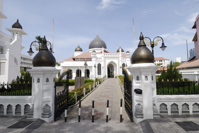
The Kapitan Keling Mosque which is situated on a busy street named after it, is the largest historic mosque in George Town. Bathed in cream and topped with large Mughal-style domes, crescents and stars, the Kapitan Keling Mosque features a madrasah for religious classes and a towering minaret from which the sound of the azan or call to prayer can be heard. Graceful arches sweep along its outer passageway allowing a cool breeze to waft through, while within the sanctuary, soaring Gothic arches open onto Moorish and Roman arces of celestial white, giving even more depth to the already spacious prayer hall.
A magnificent chandelier drips from the highest ceiling, which rises to the largest onion-shaped dome, encircled by calligraphy panels and stained glass windows featuring the Star of David. Arabesques of geometric designs and floral motifs are found throughout the mosque, whose marble floors are lined with long rows of prayer rugs.
The name of mosque was taken from the Kapitan Kelings, people who were appointed leaders of the South Indian community by the British. The term ‘keling’ derived from the ancient Hindu kingdom on the Coromandel coast of South India. It was generally used to denote all those who came from there.
Visiting hours : 01.00PM to 05.00PM ( Sat to Thurs ) and 03.00PM to 05.00PM ( Friday )
Entry fee : Free guided tours run by the Islamic Propagation Society international are available at the Islamic information Centre located at the ground floor of the minaret.
Dress code ; Visitors are required to wear robes, which are available there.
Getting there : By foot or Taxi. Kapitan Keling Mosque is on Jalan Masjid Kapitan Kling (Lebuh Pitt) in between Lebuh Chulia and Jalan Buckingham.
Karni Mata Temple Road Deshnok, NH 89, Bikaner – 334801
Phone :+91 98984 67264
Karni Mata Rat Temple is a Hindu temple dedicated to Karni Mata at Deshnoke, 30 km from Bikaner, in Rajasthan, India. It is also known as the Temple of Rats.
The Karni Mata Rat Temple temple is famous for the approximately 25,000 black rats that live, and are revered in, the temple. These holy rats are called kabbas, and many people travel great distances to pay their respects. The temple draws visitors from across the country for blessings, as well as curious tourists from around the world. The legend
Legend has it that Laxman, Karni Mata’s stepson (or the son of one of her storytellers), drowned in a pond in Kapil Sarovar in Kolayat Tehsil while he was attempting to drink from it. Karni Mata implored Yama, the god of death, to revive him. First refusing, Yama eventually relented, permitting Laxman and all of Karni mata’s male children to be reincarnated as rats.[2]
The story behind rats at the temple is different according to some local folklore. According to this version, a 20,000 strong army deserted a nearby battle and came running to Deshnoke. Upon learning of the sin of desertion, punishable by death, Karni Mata spared their lives but turned them into rats, and offered the temple as a future place to stay. The army of soldiers expressed their gratitude and promised to serve Karni Mata evermore.
Eating food that has been nibbled on by the rats is considered to be a “high honor”. If one of them is killed, it must be replaced with one made of solid silver. Architecture
The building was completed in its current form in the early 20th century in the late Mughal style by Maharaja Ganga Singh of Bikaner.
In front of the Karni Mata rat temple is a beautiful marble facade, which has solid silver doors built by Maharaja Ganga Singh. Across the doorway are more silver doors with panels depicting the various legends of the Goddess. The image of the Goddess is enshrined in the inner sanctum.
The temple was further enhanced by Kundanlal Verma of Hyderabad-based Karni Jewelers in 1999. The silver gates to the temple and the marble carvings were also donated by him.
Source : wikipedia
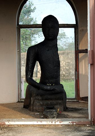
Karumadikkuttan is the endearing name of a Buddha statue found in Karumady near Alappuzha. The name literally means boy from Karumady. This 3 feet tall, black granite statue, believed to be old as 9th to 14th century, was abandoned for centuries in a nearby stream named “Karumady thodu”. Later in 1930s, Sir Robert Bristow, a colonial British engineer found the statue, and did appropriate actions to protect it. Currently the statue is under the protection of Kerala state government. Left side of the statue is missing. It is believed that it was destroyed by an elephant.
Kasauli is a cantonment and town, located in Solan district in the Indian State of himachal Pradesh . The cantonment was established by the British Raj in 1842 as a Colonial hill, 77 km from Shimla, 65 km from Chandigarh, and 94 km from Ambala Cantt (Haryana) , an important Railway Junction of North India and lies at a height of 1,927 metres (6,322 ft). The town is a health resort, having an elevation of 1,900 metres above sea level.
Kasauli Club
The Kasauli Club was established by civilians and service personnel in 1880, as the Kasauli Reading and Assembly Rooms. It gained its present name in 1898 when a limited liability company and constitution were established; its first director was Sir David Semple of Kasauli’s Pasteur Institute. At the time the Club was for the exclusive use of the British Raj, and held social meetings, tea and dinner dances, and galas. In 1915 regimental officers at Dagshai, Solan and Subathu could be admitted as honorary members. At Independence in 1947, plans to sell the then loss-making Club failed.
The Club was originally constructed of wood and plaster, and was typical of hill architecture. In 2001, after a 2000 restoration, it was destroyed by fire, losing “elegant, old-world furniture, [and] precious and rare books”. By 2005 it had been redesigned and rebuilt in stone, and plans were put forward for a new attached gymnasium.
It is currently located within Indian Army premises and managed by a regular Indian Army Officer as Club Secretary, aided by civilian staff.
In April 2012 the Kasauli Club hosted a two-day Rhythm and Blues Festival as a benefit concert for “seriously ill children”.
Manki Point
Manki Point is situated in the ‘Air Force Station’ near the Lower Mall region about 4 km from the center of town. According to the Ramayana myth, when Lord Hanuman was returning from the Himalayas after acquiring the “Sanjivany Booty”, one of his feet touched the hill; that’s why the top of the hill is in the shape of a foot. On starry and clear nights a stunning view of Chandigarh can be seen from Manki Point. The Air Force School inside the station premises is run and managed by the station workers. Cameras, cell phones or any other electronic device is not allowed like headphone, charger, selfie stick, pen drive, memory card, sim card etc. You can lock them in your vehicle or deposit them at the locker facility available (charges applicapble) at the restaurant nearby the gate from which your vehicle can’t go any further.
Other Attractions are : Baptist Church, Christ Church, Gurudwara Shri Guru Nanak Ji, Krishna Bhavan Mandir and Nahri Temple,
Burgar Street, Fort Nagar, Fort Kochi, Near PS, Kochi, Kerala 682001
Phone: 0484 221 5769
Image Credit : pinterest
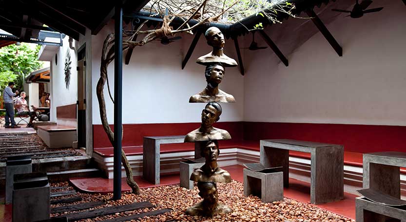
Kashi Art Gallery is a space which facilitates the discourse between art, artists, and its audience. Established in 1997, the Gallery has been built and conserved by people passionate about the arts. The gallery has supported and built many an artist, it has also had the privilege of having well-known names associate with it. The gallery welcomes art of all genres to its space.
Established in 1997, Kashi Art Café is not just a gallery space, it’s a meeting place, a point where art meets the enthusiast. It is an airy tropical garden café with a restful ambiance; a good place for exchanging ideas with people from around the world.
We keep things simple and hopefully great! We believe people like our place because they can feel the easiness of the space and taste the love that goes into everything we do. Breakfast is served at any time of the day. Lunch includes assorted sandwiches and salads and a hearty soup of the day. And of course the perfect accompaniment to our freshly made cakes and pies would be the special cup of coffee or the perfect cup of tea.
Source : kashiartgallery.com . kashiartgallery.com/cafe/ https://www.youtube.com/watch?v=V7qI-Z7KZj0 https://www.youtube.com/watch?v=ObQG9FqN1_g https://www.youtube.com/watch?v=0T555ERgC4U Reviews https://goo.gl/mQ7WVa
Kasol is a village in Himachal Pradesh. It is situated in Parvati Valley, on the banks of the Parvati River, on the way between Bhuntar to Manikaran. It is located 42 km east of Kullu at the height of 1640 meters. Those who visit Manikaran can incude this in the itinerary. It is known as a mini Israel in Himachal Pradesh. It is an ideal destination for backpackers, trekkers and nature enthusiasts due to its scenic valley, untouched mountains and great climate throughout the year. Due to inflow of Israeli tourists, it is full of restaurants and shops. All the signboards of the restaurants and shops are also written in Hebrew language. Most of the restaurants and café’s serve Israeli cuisine along with local dishes. Kasol enjoys pleasant weather throughout the year.
KL Bird Park, 920, Jalan Cenderawasih, 50480 Kuala Lumpur, Malaysia.
Phone : +60 3-2272 1010
Internal view of the Bird park
The Kuala Lumpur Bird Park is a 20.9-acre (8.5 ha) public aviary in Kaula lumpur, Malaysia. It is a popular tourist attraction in the country, receiving an annual average of 200,000 visitors. It is located adjacent to the Lake Gardens. The Bird Park houses more than 3000 birds representing more than 200 species in an enclosed aviary. 90% are local birds and 10% were imported from overseas.
The bird park is part of the 60-hectare (150-acre) Lake Gardens, which were established in 1888. In addition to the 20.9-acre (8.5 ha) bird park, which was created in 1991, the gardens include an artificial lake, the National Monument, the Kuala Lumpur Butterfly Park, the Deer Park, Orchid and Hibiscus gardens, and the former Malaysia Parliament House. It is one of the world’s largest covered bird parks.
Bird-watching is a common activity here where the flora and fauna is rich. The Kuala Lumpur Bird Park has earned a reputation among those who are keen on the study of birds in their natural habitat. Some of them include research scientists who monitor bird nests for the study of behavioral patterns.
Source : Wikipedia
One of KL Bird Park’s most extraordinary feature is that in Zone 1, 2 and 3, birds are let free in the aviary which closely resembles their natural habitat. With this free-flight concept, birds are able to breed naturally in this unique environment.
Compared to Singapore’s Jurong Bird Park, the Kuala Lumpur Bird Park is twice the size of Jurong and most of its birds are free and accustomed to being around people. Among the birds, the Indian blue peacock, with its colourful five-foot train, and the crowned pigeon, the largest pigeon species in the world are included..
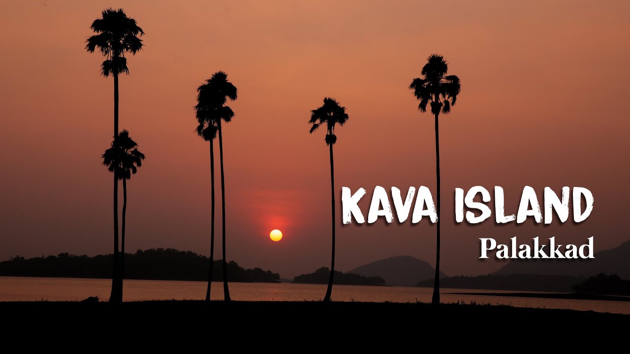
Kava is a beautiful green-land surrounded by mountains all around and its near the Malampuzha dam and is hardly 13km from Palakkad.
The gateway of rains to Kerala, Kava Viewpoint at Malampuzha in Palakkad district is the finest destination in the state to chase the monsoon amid a perfect background of hills and reservoir. Located behind Malampuzha Dam, Kava is also a favourite destination of shutterbugs for the splendid sunset in shining hues. The forest en route to Kava village is home to rare birds and butterflies. https://www.youtube.com/watch?v=oejMvDXguGU https://www.youtube.com/watch?v=QIHN1y1Plj8 Reviews https://bit.ly/3yPETa4
The town of Kaza, Kaze or Kaja is the subdivisional headquarters of the remote Spiti Valley in the Lahaul and Spiti district of the state of Himachal Pradesh in the Western Himalayas of India. Spiti, which is a part of the Lahaul and Spiti district of Himachal, is a high altitude or cold desert having close similarities to the neighbouring Tibet and Ladakh regions in terms of terrain, climate and the Buddhist culture. Situated along the Spiti river at an elevation of 3,650 metres (11,980 ft) above mean sea level, it is the largest township and commercial center of the valley
The town is divided into the old, as Kaza Khas and new as Kaza Soma sections. The new town contains the administrative buildings. The Tangyud (Tang-rGyud) Gompa dates to the early 14th century and is built like a fortified castle with massive slanted mud walls and battlements with vertical red ochre and white vertical stripes. It is on the edge of a deep canyon and overlooking the town. Approaching it from the south one sees Kyu-ling (Skyid-gling), the stately palace of the Nono (king) on the other side of the river.
Kaza is known for its colorful festivals and the ancient Sakya Tangyud Monastery in a side valley, 4 km from the town. It is also popular with tourists and adventure seekers during summer months because of its central location and connections to rest of the valley and outside. This central location also makes it an ideal base camp for trekking, mountaineering and tours directed to other parts of the valley.Some of the major tourist attractions in and around Kaza beside Tangyud Monastery are the Key Gompa, Kibber village at an elevation of 4205 m. above MSL, Gette Village at an altitude of 4270 m above MSL, Langza village famous for presents of marine fossils, the Pin Valley National Park, a protected area for himalayan high altitude wildlife and the Losar village 40 km to the north of Kaza at an altitude of 4079 m above MSL.
Kek Lok Si Temple, 11500 Ayer Itam, Pulau Pinang, Malaysia
Phone : 04-82833174-8283317
Kek Lok Si TempleKek Lok Si pagoda tiers labelled with their architectural styles
The Kek Lok Si Temple or “Temple of Supreme Bliss” or “Temple of Sukhavati ” or “Jile Si” is a Buddhist temple situated in Air Itam in Penang facing the sea and commanding an impressive view, and is one of the best known temples on the island. It is said to be the largest Buddhist temple in Malaysia. It is also an important pilgrimage centre for Buddhists from Hong Kong, the Philippines, Singapore and other countries in Southeast Asia. This entire complex of temples was built over a period from 1890 to 1930, an inspirational initiative of Beow Lean, the Abbot. The main draw in the complex is the striking seven-storey Pagoda of Rama VI (Pagoda of Ten Thousand Buddhas) with 10,000 alabaster and bronze statues of Buddha, and the 30.2 metres (99 ft) tall bronze statue of Kuan Yin , the Goddess of Mercy.
Mahayana Buddhism, Theravada Buddhism and traditional Chinese rituals blend into a harmonious whole, both in the temple architecture and artwork as well as in the daily activities of worshippers. The temple is heavily commercialised with shops at every level and inside the main temple complexes selling all religious paraphernalia.
Most visitors approach the temple as they ascend a stairway, roofs of which provide shelter to a multitude of shops selling souvenirs and other – mostly secular – commodities. They pass by a so-called Liberation Pond, following the Buddhist tradition of merit-making, turtles may be released into freedom, albeit a limited one.
The Kek Lok Si temple itself consists of several large prayer halls and pavilions for assembly and prayer, statues of Buddha; various Bodhisattvas as well as Chinese gods are being venerated. The architectural features include carved pillars, fine woodwork, mostly painted in bright colours, and a plethora of lanterns add to the visual impression. Fish ponds and flower gardens are also part of the Kek Lok Si temple complex.
There is a cable car to carry pilgrims and visitors further uphill. On the elevated platform, there is a fish pond, and the towering statue of Kuan Yin, Goddess of Mercy which is worshipped by women to beget children. The monks and nuns, who are housed in a monastery and who are incharge maintenance and operation of the temple complex, consider it as a spiritual retreat to attain salvation.
Visiting hours : 7.00am to 9.00pm, all days of the week
Entrance fee : Free to enter the temple, but you have to pay RM2 if you want to visit the Pagoda and RM2 each way to use the inclined lift.
Getting there : Bus numbers 201, 203 or 204 will take you to the base of the temple where you have to walk up the narrow lane and stairway full of the souvenir shops.
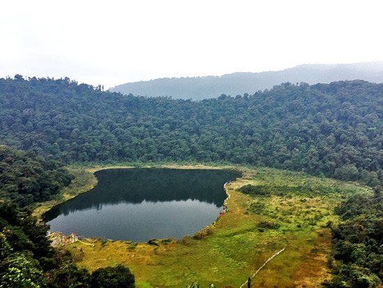
Keoladeo National Park is a World Heritage Site and is about 180 kms from Delhi and 55 kms from Agra.
It is better to visit this place while visiting Agra.
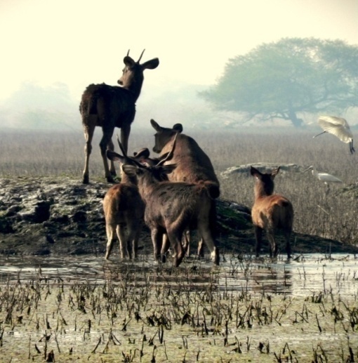
The Keoladeo National Park or Keoladeo Ghana National Park formerly known as the Bharatpur Bird Sanctuary in Bharatpur, Rajasthan, India is a famous avifauna sanctuary that plays host to thousands of birds especially during the winter season. Over 230 species of birds are known to have made the National Park their home. It is also a major tourist centre with scores of ornithologists arriving here in the hibernal season. It was declared a protected sanctuary in 1971.
Keoladeo Ghana National Park are home to 366 bird species, 379 floral species, 50 species of fish, 13 species of snakes, 5 species of lizards, 7 amphibian species, 7 turtle species, and a variety of other invertebrates. Every year thousands of migratory waterfowl visit the park for wintering and breeding. The sanctuary is one of the richest bird areas in the world and is known for nesting of resident birds and visiting migratory birds including water birds. The rare Siberian cranes used to winter in this park but this central population is now extinct. According to founder of the World Wildlife Fund Peter Scott, Keoladeo National Park is one of the world’s best bird areas. Alongwith the Loktak Lake of Manipur, Keoladeo National Park is placed on the Montreux Record under the Ramsar Convention.
The Keoladeo National Park can be easily covered on foot or on a cycle or on a hired rickshaw. Rickshaw pullers have been trained by the park management in bird watching and are quite knowledgeable. Boats are also available on hire. A boat trip early in the morning or late evening is quite a pleasing experience.
Pandit Karuppan Road, Near Thevara Ferry Junction, Kochi, Kerala 682013
Phone: 070347 77499
Image Credit : keralafolkloremuseum.org
Step into this three-storied edifice and take a stroll down history where every waft that you encounter is scented with times gone by, its culture and heritage. This is Kerala Folklore Theatre and Museum at Thevara, Ernakulam – a unique venture to preserve the splendid folklore wealth of the State.
Opened in the year 2009 as a non-profit organization, the museum is truly a treasure trove that showcases the rich heritage that Kerala exudes through its numerous art and dance forms. Artifacts that bear the scent of bygone era like masks, sculptures, in wood, stone and bronze, costumes of traditional and ritual art forms, musical instruments, traditional jewelry, manuscripts of rare medicinal and astrological secrets, and Stone-Age utensils are all preserved in this museum with utmost care.
The building itself is a piece of wonder with its three floors following the architectural styles of Malabar, Cochin and Travancore. The entrance to this marvelous structure is constructed from the remnants of a 16th century temple in Tamil Nadu and wooden carvings collected from across Kerala. The entrance door is decked with an attractive manichitratazhu (a traditional ornate door lock of Kerala). Near to this entrance door are pierced wooden windows, reminiscent of the intriguing Malabar style of architecture.
The first floor with the Cochin architectural style is sagaciously named as kalithattu, which means a floor for play and it displays costumes of various traditional and ritual dance forms of Kerala like Theyyam, Kathakali, Ottanthullal, and Mohiniyattam. Kanjadalam; or lotus petal is the name given to the second floor, which is adorned with fascinating mural paintings and has a chiseled wooden ceiling made of 60 frames.
The theatre here conducts authentic stage performances every day at 6.30 p.m. Kerala Folklore Theatre and Museum is the outcome of 25 years of efforts and determination of George Thaliath and his wife Annie George along with the inimitable craftsmanship and manpower put in by 62 carpenters and skilled workers for more than seven years.
Source : keralatourism.org https://www.youtube.com/watch?v=XVGFNOmCliU Reviews https://goo.gl/8JZkCc Visiting hours : 09.00AM to 06.00PM Entry : Rs.100/-for adults and Rs.50/- for students
Kerala Kalamandalam, deemed to be University of Art and Culture by the Government of India, is a major center for learning Indian performing arts, especially those that developed in the Southern states of India, with the special emphasis on Kerala. It is situated in the small town of Cheruthuruthy in Thrissur, Thrissur District on the banks of the Bharathapuzha river.
The inception of Kalamandalam gave a second life to three major classical dance performing arts of Kerala as Kathakali, Kudiyattam and Mohiniyattam were, by the turn of the 20th century, facing the threat of extinction under various regulations of the colonial authorities. It was at this juncture, in 1927, that Vallathol Narayana Menon and Mukunda Raja came forward and formed a society called Kerala Kalamandalam.
The first Prime Minister to visit Kerala Kalamandalam is Jawaharlal Nehru in 1955 for the Silver Jubilee of the Kerala Kalamandalam. Indira Gandhi was the second Prime Minister to visit Kerala Kalamandalam in 1980 and V. P. Singh in 1990. Manmohan Singh is the fourth Prime Minister to visit Kerala Kalamandalam in September 2012.
Source : wikipedia https://www.youtube.com/watch?v=I-oLzeJUwQ4 https://www.youtube.com/watch?v=O5vrEej1qqM Reviews https://bit.ly/3fD3Jl8 Visiting Time: The tour is open on all working days from 0930 – 1300 hours. The tour services are closed on all national holidays. Entrance Fee: A tour is specially tailor made for the visitors to educate them about Kerala’s rich and diverse culture. For foreign tourists, it costs $20 per head and for Indian tourists Rs. 1000 per head.
Address: KB Jacob Rd, Fort Nagar, Fort Kochi, Kochi, Kerala 682001
Phone:0484 221 5827
Image Credit : keralakathakali centr.com
The Kerala Kathakali Centre was founded in 1990 in Kochi , the oldest city in Kerala and known as the Queen of the Arabian Sea .
The Kerala Kathakali Center’s aim is to popularize and encourage the classical arts of Kerala, discover new talents, and improve the standards of training and performances by rigorous discipline and dedication. Various traditional arts and rituals are also encouraged and performed at our Centre. HISTORY OF KATHAKALI
Elements of the art of Kathakali are found in the ancient ritual plays of Hindu temples and various dance forms that are believed to have been gradually developed in Kerala from as early as the 2nd Century until the end of the 16th Century. Many of its characteristics are very much older than its literature, as they are a continuation of older traditions, but these did not crystallize until the 17th Century when the Rajah of Kottarakkara, a small principality in central Travancore, wrote plays based on the Hindu epic “Ramayana” in sanskritized Malayam, which could be understood by ordinary people. Before this, the stories were enacted in pure Sanskrit, which was known only to the learned few.
From then on, Kathakali emerged as an individual style of dance-drama into a “people’s theatre” from the traditional dances of the past. The plays were performed by the Rajah’s own company of actors, not only in temples and courts, but from village to village and house to house. The new art form (called Ramanattan) soon became very popular all over the Malayalam-speaking area. The feudal chieftains of Malabar (as the area was then called) began to vie with one another in their efforts to produce the best Kathakali troupes and this competition contributed to the rapid development of the art in a very short period.
Welcome to Gods Own Country and its Traditional Wonders.
Source : kathakalicentre.com https://www.youtube.com/watch?v=hy_evjVTNfo https://www.youtube.com/watch?v=r1dpccX0Yhw Reviews https://goo.gl/mc9a1e
Visiting hours : Opening Closing Time
Kalaripayttu (Martial Arts) Show
04:00 pm – 5:00 pm
Kathakali Demonstration and Show
06:00 pm – 07:30 pm
Indian Classical Music Show (by special guest artists)
08:00 pm – 09:00 pm
Meditation
08:00 am – 09:00 am
Yoga
06:30 am – 08:00 am
09:00 am – 10:30 am
Daily – Yoga and Meditation
Saturday – Classical Dance” Entrance Fee
Rs. 300 for Kathakali / Rs. 300 for Indian Classical Dance / Rs. 250 for Indian Classical Music / Rs. 250 for Martial Art / Rs. 200 for Meditation / Rs. 350 for Yoga
PMG Junction, Vikas Bhavan P.O, Thiruvananthapuram, Kerala 695033
Phone : +91 471 230 6025
Image Credit : tripadvisor.in
Kerala Science Technology Museum is an autonomous institution established by Government of Kerala, India, in 1984 as a center for popularisation of science and scientific temper among the general public, especially among the young generation. The institution is located in the heart of Thiruvananthapuram city, in Kerala. There is also a planetarium, called Priyadarsini Planetarium, attached to the Museum functioning since 1994.
Galleries
Kerala Science Technology Museum has ten galleries exhibiting more than 300 items. Each gallery contains items related a particular disciple of science or engineering. There are galleries for electrical, electronics, mechanical, automobile and bio-medical engineering. There is a special gallery for popular science, and also for solar energy. Mathematics, computer science and space science are the other disciplines having galleries of their own.
Science popularisation efforts
In addition to the Planetarium, the Museum offers facilities for night sky observation with a fully automatic 11 inch telescope. The Museum operates two Mobile Science Exhibition Units on astronomy and science and a separate mobile astronomy unit named Astrovan. The Museum also conducts creative science workshops for school children during every summer.
Administration
The administration of the museum is vested with a Governing Body with Minister for Education, Kerala State, as the Chairman. The Director of the Museum is responsible for conducting the day-to-day affairs of the museum.
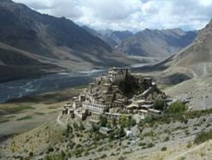
Kye monastery (also spelled Ki, Key or Kee – pronounced like English key) is a Tibetan Buddhist monastery located on top of a hill at an altitude of 4,166 metres (13,668 ft) above sea level, close to the Spiti River, in the Spiti Valley of Himachal Pradesh, Lahaul and Spiti district, India.
It is the biggest monastery of Spiti Valley and a religious training centre for Lamas. It reportedly had 100 monks in 1855.
The walls of the monastery are covered with paintings and murals, an example of the 14th century monastic architecture, which developed as the result of Chinese influence.
Kye monastery has a collection of ancient murals and books, including Buddha images.
Kye monastery has three floors, the first one is mainly underground and used for storage. One room, called the Tangyur is richly painted with murals. The ground floor has the beautifully decorated Assembly Hall and cells for many monks.
Kye Gompa now belongs to the Gelugpa sect, along with Tabo Monastery and Dhankar Gompa, one of three in Spiti.
“The monastery of Kee, for instance, accommodates nearly 250 monks, who reside within the sacred walls in winter, and stay during the summer with their parents or brothers, working in the fields, or employed in carrying travellers’ goods. These monasteries have their regular heads, or abbots, and the higher ecclesiastical titles can only be obtained by the candidates proceeding in person to either Shigatzee (Shigatse) or Lhassa (Lhasa).”
A celebration of its millennium was conducted in 2000 in the presence of the Dalai Lama. A new Prayer Hall was inaugurated on 3rd August, 2000 by HH The Fourteenth Dalai Lama.
Source : wikipedia
Khajjiar is a Hill Station in Chamba District, Himachel Pradesh, India, located approximately 24 km from Dalhousie.
Khajjiar sits on a small plateau with a small stream-fed lake in the middle that has been covered over with weeds. The hill station is surrounded by meadows and forests. It is about 6,500 feet (2,000 m) above sea level in the foothills of the Dhauladhar ranges of the Western Himalayas and peaks can be seen in the distance. It is part of the Kalatop wildlife Sactuary.
Khajjiar can be reached from Dalhousie, the nearest major town and hill station. It has a rare combination of three Ecosystems: Lake,pasture and Forest.
On 7 July 1992, Mr. Willy T. Blazer, Vice Counselor and Head of Chancery of Switzerland in India brought Khajjiar on the world tourism map by calling it “Mini Switzerland”. He also put a Sign Board Of A Yellow Swiss Hiking Footpath showing Khajjiar’s distance from the Swiss capital Bern -6194 km. It is among the 160 locations in the world that bear topographical resemblance with Switzerland. The counselor also took from here a stone which will form part of a stone collage around the Swiss Parliament to remind the visitors of Khajjiar as a Mini Switzerland of India.
Entertainment
The best entertainment here is to walk around the lake or to go for long walks in the thick pine forests. Children enjoy this place because of the freedom of movement and the sloped terrain which permits them to roll down to the lake without getting hurt. Another attraction is horse riding.
Khajjiar Lake
Khajjiar Lake is a small lake, surrounded by saucer-shaped lush green meadow and a floating island. The dense growth of weed called vacha has made its earth spongy. Now the banks stand covered by a thick layer of earth, formed by the years of dust settling down on the weeds.
Trekking
Khajjiar to Dainkund is a 3.5 kilometre easy to moderate trek. The trek starts 6 kilometres from Khajjiar on the Dalhousie-Khajjiar road and ends at Pholani Devi Temple at Dainkund. This trek with a well-defined trail and moderate ascent is an excellent trek for beginners and children. The trek offers excellent views and a beautiful camping site.
Khangchendzonga National Park (previously named Kanchenjunga National Park) also Kanchenjunga Biosphere Reserve is a National Park and a Biosphere reserve located in Sikkim, India. It was inscribed to the UNESCO World Herotage Sites list on July 17, 2016, becoming the first “Mixed Heritage” site of India. The park gets its name from the mountain Kanchenjunga which is 8,586 metres (28,169 ft) tall, the third-highest peak in the world. The total area of this park is 849.5 km2 (328.0 sq mi).
There are many glaciers in the park including the Zemu glacier. The vegetation of the park include temperate broadleaf and mixed forests consisting of oaks, fir, birch, maple, willow etc. The vegetation of the park also includes alpine grasses and shrubs at higher altitudes along with many medicinal plants and herbs.
Khangchendzonga National Park contains many mammal species including musk deer, snow leopard, Himalayan tahr, wild dog, sloth bear, civet, Himalayan black bear, red panda, Tibetan wild ass, Himalayan blue sheep, serow, goral and takin, as well as reptiles including rat snake and Russell’s viper.
A recent study revealed, that the Asiatic wild dog has become very rare in the area. The wild dogs in the Khangchendzonga Biosphere Reserve are believed to belong to the rare and genetically distinct subspecies C. a. primaevus
About 550 species of birds are found inside the park including blood pheasant, satyr tragopan, osprey, Himalayan griffon, lammergeyer, Tragopan pheasant , green pigeon, Tibetan snowcock, snow pigeon, impeyan pheasant, Asia emerald cuckoo, sunbird and eagle.
Trekking[
Most of the trekking routes starts from Yuksom (145 km (90 mi) from Gangtok) in West Sikkim. Necessary Permit can be obtained from the Wildlife Education and Interpretation center at Yuksom or from the check post. State Tourism Department along with other travel agents organize treks to Dzongri (4,050 metres (13,290 ft)) and other places. The popular trek routes are:
Another popular trekking point includes trekking to the Green Lake with Lachen, a village in North Sikkim as the starting point. Foreign nationals would require a restricted area permit from the Ministry of Home Affairs, Government of India, Delhi to visit the park and the associated region. Indian nationals are required to obtain an Inner-Line Permit from the State Home Department. Permission of the State Chief Wildlife Warden is also mandatory for everybody visiting the park. The important and popular routes are:
Lucanes Jakchen-Yabuk-Rest Camp (Marco Polo Camp) – Green Lake
Lachen-Thasngu (13,695 feet (4,174 m)) – Muguthang (16,000 feet (4,900 m)) – Thay La (17,000 feet (5,200 m)) – Khyoksa La (18,000 feet (5,500 m)) – Rest Camp – Green Lake.
Most of these trekking routes pass through the Kanchenjunga National Park.
Khecheopalri Lake, is a lake located near Khecheopalri village, 147 kilometres (91 mi) west of Gangtok in the West Sikkim district of the Northeastern Indian state of Sikkim.
Located 34 kilometres (21 mi) to the northwest of Pelling town, the lake is sacred for both Buddhists and Hindus, and is believed to be a wish fulfilling lake. The local name for the lake is Sho Dzo Sho, which means “Oh Lady, Sit Here”. The popularly known name of the lake, considering its location is Khecheopalri Lake, ensconced in the midst of the Khechoedpaldri hill, which is also considered a sacred hill.
The lake is an integral part of the much revered valley of “Demazong” meaning valley of rice. This landscape is also known as a land of hidden treasures blessed by Guru Padmasambhava.
The Khecheopalri Lake is also part of Buddhist religious pilgrimage circuit involving the Yuksom, the Dubdi Monastery in Yuksom, Pemayangtse Monastery, the Rabdentse ruins, the Sanga Choeling Monastery, and the Tashiding Monastery. An interesting feature of the lake is that leaves are not allowed to float on the lake, which is ensured by the birds which industriously pick them up as soon as they drop into the lake surface.
18, Cannon Square, 10450 George Town, Pulau Pinang, Malaysia
Phone : +60 4-261 4609
The Khoo Kongsi temple in PenangMain entrance of the Khoo KongsiAltar with ancestral tablets
The Khoo Kongsi Temple is a large Chinese clan house with elaborate and highly ornamented architecture, a mark of the dominant presence of the Chinese in Penang in Malaysia.. The famous Khoo Kongsi is the grandest clan temple in the country. It is also one of the city’s major historic attractions. The clan temple has retained its authentic historic setting, which includes an association building, a traditional theatre and the late 19th century row houses for clan members, all clustered around a granite-paved square. It is located in Cannon Square in the heart of the oldest part of the city of George Town, in the midst of narrow, winding lanes and quaint-looking pre-war houses exuding a palpable old world charm.
Visiting hours: 09.00AM to 05.00PM, all days of the week
Entry fee : RM 10
Getting there : The temple can not be seen from the street. To find the entrance – Walk along (Lebuh) Cannon Street towards the Acheen Street Mosque, which you can see at the end of the road. You will find the entrance to the Temple compound on your left.
KidZania is one of the fastest growing kid’s hands-on entertainment brands in the world. It is an interactive indoor theme park combining inspiration, fun and learning through realistic role-play for children aged 4 to 17. At KidZania Singapore, kids can independently explore an 81,000 square feet kid-sized city, complete with buildings, paved streets, vehicles and a functioning economy, just like in a real world! Through realistic role-play, they learn about different careers, the inner-workings of a city and the concept of managing money. It is designed to educate through experience, fostering the development of life skills, giving kids the confidence and inspiration to be great global citizens. KidZania has become a global phenomenon with numerous locations throughout the world. Each KidZania location offers experiences that are relevant to a particular region, culture and geography by way of food, entertainment and professions. Each activity is carefully crafted in close collaboration with real-world brands to ensure the realism and authenticity that is synonymous with the brand.
Beyond the presence of familiar sights and sounds of both local and international brands, KidZania Singapore also prides itself to be the first KidZania in the world to house a full-wing fuselage of a Boeing 737. Located on Sentosa Island, it is also the first KidZania city to be located on an island resort. So Z-U at KidZania Singapore, where big dreams start here!
Source : kidzania.com.sg
Big dreams start here at KidZania Singapore, where children are free to be who they want to be!
Spanning over 81,000 square feet, equivalent to 6 Olympic-sized swimming pools, KidZania Singapore offers children real-life experiences through many different role-play activities in the kid-sized city. Children can learn to pilot an airplane, perform a surgery or whip up a meal as a chef!
More than simply an indoor themed park, children can experience all the role-play activities, earn salary in the form of kidZos, the official currency of KidZania, and pay for goods and services. Through such diverse and interactive learning experiences, children can learn to develop valuable life skills such as responsibility, confidence and independence, that will help them follow their dreams and get ready for a better world!
Source : staging.sentosa.com.sg
Sunday – Thursday: 10am – 5pm
Friday, Saturday, Eve of Public Holidays, Public Holidays and School Holidays: 10am – 8pm
Admission Walk-in:
– Kid (4 – 17 years old) – $58
– Adult (18 – 59 years old) – $35
– Toddler (2 – 3 years old) – $25
– Senior (60 years old and above) – $25
– Infant (under 2 years old) – Free Online:
– Kid (4 – 17 years old) – $55.10
– Adult (18 – 59 years old) – $33.25
– Toddler (2 – 3 years old) – $23.75
– Senior (60 years old and above) – $23.75
– Infant (under 2 years old) – Free
Getting There
By Sentosa Express: Alight at Beach Station. Transfer to the Sentosa Beach Tram.
By Bus: Sentosa Bus 1, Bus 2 and Bus 3 and alight at Beach Station. Transfer to the Sentosa Beach Tram.
By Sentosa Beach Tram: Alight at Port of Lost Wonder stop
By Foot: Take a stroll down the beach from Beach Station
Kleftiko is an impressive spot of rock formations that can be reached only by sea.
At first sight, the place will look familiar as it is pictures in most travel guides about the island. Impressive rocks spring up from the sea, forming natural caves and rare geological phenomena. It is also known as The Sea Meteora.
The legend says that one of the caves in here was a pirate hideaway and that they had hidden in there their treasury, but it was never found. The water here is crystal and many people jump from the tour boats to swim. Close to Kleftiko, there is another impressive place of such geological formation, Gerontas.
Source : Greeka.com https://www.youtube.com/watch?v=N4G0uUPJlnA https://www.youtube.com/watch?v=dq0eJdp7h38 https://www.youtube.com/watch?v=_4MiS9D7RDY Reviews https://bit.ly/3c6f1Ll
Kovalam is a beach town by the Arabian Sea in Thiruvananthapuram city, Kerala, India, located around 16 km from the city center. Kovalam means a grove of coconut trees and true to its name the village offers an endless sight of coconut trees.
Kovalam has three beaches separated by rocky outcroppings in its 17 km coastline, the three together form the famous crescent of the Kovalam beach.
The southernmost beach, the Lighthouse Beach is the one most frequented by tourists, Lighthouse Beach got its name due to the old Vizhinjam Lighthouse located on a 35 meter high on top of the Kurumkal hillock. The lighthouse is built using stones, is colored in red and white bands and enjoys a height of 118 feet. It’s intermittent beams at night render the beach with an unearthly charm.
Eve’s Beach, more commonly known as Hawa Beach, ranks second, in the early day, is a beehive of activities with fishermen setting out for sea. With a high rock promontory and a calm bay of blue waters, this beach paradise creates a unique aquarelle on moonlit nights.
A large promontory separates this part from the southern side. Samudra Beach doesn’t have tourists thronging there or hectic business. The local fishermen ply their trade on this part.
Detour past Kovalam junction to land on Samudra Beach which is to the north of Ashoka Beach. One has the option to walk along the sea-wall too.The sight of the waves lashing on the rocks below is awesome.
Shallow waters stretching for hundreds of metres are ideal for swimming. The beaches have steep palm covered headlands and are lined with shops that offer all kinds of goods and services.
Evening time view of the beach – Image Credit : keralatourism.org
The larger of the beaches is called Lighthouse Beach for its 35 metre high light house which towers over it atop Kurumkal hillock. The second largest one is Hawah Beach named thus for the topless European women who used to throng there. It was the first topless beach in India. However topless bathing is banned now except in private coves owned by resorts. Visitors frequent these two beaches. The northern part of the beach is known as Samudra Beach in tourism parlance. A large promontory separates this part from the southern side. Samudra Beach doesn’t have tourists thronging there or hectic business. The local fishermen ply their trade on this part. The sands on the beaches in Kovalam are partially black in colour due to the presence of ilmenite and Monazite. The normal tourist season is from September to May. Ashoka beach is also the part of Kovalam beach.
Phone : + 91 484 2647025, Mobile : + 91 8547603786
Elephants are considered as auspicious animals in Kerala. No major festival or celebration in Kerala is complete without a massive elephant processions. Considered an important part of our culture, elephants are loved, revered and groomed with the utmost care and respect.
The Kodanad Elephant Training Center, which was moved to Abhayaranyam near Kaprikkad, is one of the largest elephant training centers in Kerala. It is flanked by the high ranges and is set near the southern banks of the Periyar River. Since the ban on capturing elephants was enforced, this place now serves as one of the premier elephant training centers in Kerala. Muthanga of Wayanad and Konni of Pathanamthitta are two other elephant training centers. One may also visit PunnathurKotta in Thrissur where over 40 elephants specially groomed for the Guruvayur Temple are kept. It is surely every elephant lover’s paradise to view these magnificent beings up close.
Source : https://rb.gy/isvbgz https://www.youtube.com/watch?v=FjvMiYg3aPY https://www.youtube.com/watch?v=l9l5KnDKEys https://www.youtube.com/watch?v=uB3VndfXIVM Review https://rb.gy/mjscvp Visiting hours : 08.00 to 17.00 Monday Closed Entry Fee : Rs. 30.00 Per adult and rs.20/-For Kids
The Palliyara Sree Bhagavathy Temple, renowned to the devotees as the Chilanthi Ambalam (place of worship dedicated to sanctified or deified spider) is a sacred temple of worship for those ailing and suffering from spider poison or toxins.
Kodumon in Pathanamthitta district is also the birth place of Sree Sakthibhadra, the author of the famous Sanskrit play, “Ascharya Choodamani “. An organization entitled Sakthibhadra Samskarika Kendram is now functioning at Kodumon with a view to erect a proper and befitting memorial to Sakthibhadra. He was the first among the Sanskrit Scholars of South India in the 9th century AD to compose an admirably full blown drama. The Ascharya Choodamani was the first among the original Sanskrit dramas of South India.
10 KM away from Adoor and 11 km from Pathanamthitta, the temple is located in the back drop of the Sakthibhadra Samskarika Kendram Complex which is located one kilometer east of the Kodumon market centre on the Chavara Pathanamthitta P.W.D road. It is believed to be only one of its kind in India which attracts thousands of devotees from far and near for the purpose of divine healing.
Is there any better place to have a refreshing cup of tea than the hills of Kolukkumalai, which are home to the highest tea plantations in the world? And the tea grown here has a special flavour and freshness, thanks to the high altitude.
The sprawling plantations and an old tea factory lend an old world charm to this place. Go on a guided tour through the factory. The two-storied building, built in the 1930s, with its wooden interiors and aroma would present you some time-tested methods of tea processing. Here tea is processed in the traditional method, which is different from the more popular CTC (crush-tear-curl method). Tea lovers will be pleased to sip different varieties of tea from the tea tasting centre here. Those wanting to take home the flavour, can buy fresh packets from the outlet attached to the factory. There are different varieties to choose from like the Broken Orange Pekoe (BOP) and the Flowery Orange Pekoe (FOP). Get some tips from the salesmen on how to extract the different tastes.
Kolukkumalai is about 7,900 ft above sea level and you can have some excellent views of the far off plains in the bordering State of Tamil Nadu. The distant hills slipping in and out of the mist is a captivating sight.
The rolling acres of tea are an experience in itself for the visitors. Take a lovely stroll on the pathways in the plantations. The more adventurous can take a walk down a fairly steep and narrow bridle path leading to the plains. Only with awe can you hear that this route was once the only option for the estate workers to carry tea chests down and bring provisions to their residence.
Phone : +65 6849 5300
This photo of Kong Meng San Phor Kark See Temple is courtesy of TripAdvisor
The Kong Meng San Phor Kark See Monastery , is a Buddhist temple located in Bishan, Singapore. Built by Zhuan Dao in the early 20th century to propagate Buddhism and to provide lodging for monks, this monastery is the largest Buddhist temple in Singapore.
The modern day monastery premises consist of stupas, prayer halls, crematorium and columbarium which houses over 200,000 niches, bell and drum towers, and an outdoor statue of Avalokitesvara stands between the Dharma Hall and the Pagoda of 10,000 Buddhas. The Hong Choon Memorial Hall of the temple was built in 2004. Another notable feature of the monastery is a Bodhi Tree which had its sapling brought from the sacred Bodhi tree at Anuradhapura, Sri Lanka, which was itself brought as a sapling from the sacred Bodhi Tree of Bodh, Ondia where Shakyamuni Buddha was said to have attained enlightenment.
The largebronze Buddha Statue located in the temple’s Hall of No Form is one of Asia’s largest Buddha statue, with a height of 13.8 metres and weighing 55 tons. Apart from a $12 million four-storey carpark with about 200 spaces that was added in 2014, a six-storey $35 million Buddhist college for monks is also nearing completion.
The Kong Meng San Phor Kark See Monastery celebrates Vesak Day annually] with a variety of ceremonies such as “Bathing the Buddha”, and “Three-Steps-One-Bow”. Other major events include Ching Ming. As the East Asian traditional practice of burning incense and joss materials remain despite repeated pleas and discouragement, costlier alternatives appeared which include the installation of a new four-storey, $1 million eco-friendly burner in 2014
This photo of Konni Elephant Training Center is courtesy of TripAdvisor
Konni is a major town and a Taluk headquarters in Pathanamthitta district , Kerala, India. The lush green land has been prominent as a haven of wild elephants and as an elephant training center. The large area of thick forest with wild animals made Konni to emerge as another tourist spot for safaris and trekking. In Kerala there are two elephant training centers, the other located at Kodanad.
Konni has a major elephant training center, located 11 km from Pathanamthitta. The prime attraction here are the huge cages of wood built to house elephants. These cages are locally known as Aanakoodu and can accommodate 3 to 4 elephants at a time. The trainers here train the baby elephants which get separated from their herd, or are found wounded or roaming in the forest. Experienced trainers using their systematic training methods, tame the baby elephants. Visitors can get a close look at these elephants and can observe and understand a lot about their behaviour, especially that of baby elephants, which are often endearingly mischievous.
The elephants were captured from the dense forests of the western ghats/Sahyadri and brought to the elephant training cage at Konni. There these wild elephants are tamed and trained by mahouts specialized as elephant trainers. These trainers take the help of other tamed elephants.
Presently the elephant training cage is a major tourist attraction. Konni Elephant training center houses a history museum as well. The Konni elephant training center functions as an elephant welfare center. The elephant calves estranged from the herd and found lost in the forest are brought here and are provided with medical facilities and proper care.
The Administrator, Koodalmanikyam Devasom, Trissur District, Irinjalakuda, Kerala 680121
Phone: 0480 282 6631
Image credit : https://commons.wikimedia.org/
Koodalmanikyam Temple is a Hindu temple in Irinjalakuda Municipality, Thrissur district, Kerala. The temple comprises a main structure, a walled compound with citadels, and four ponds around the main structure one of which is within the walls. Koodalmanikyam Temple is the only ancient temple in India dedicated to the worship of Bharata, the third brother of Rama, however the idol is that of god Vishnu. “Sangameshwara” (“the Lord of the Confluence”) is another name associated with the deity at Koodalmanikyam. The temple is one of four in Kerala that form a set called “nalambalam”, each temple dedicated to one of the four brothers in the epic Ramayana: Rama, Bharata, Lakshmana and Shatrughna.
The Thachudaya Kaimal as “Manikkam Keralar” is the spiritual chief and the temporal ruler of the Koodalmanikyam Temple and its estates. The line goes back to antiquity and is mentioned in the sacred Skanda Purana. The temporal rights over the temple, that is the office of the kaimal (as opposed to “Manikkam Keralar”) and the office of “melkoyma”.
The earliest historical reference to Koodalmanikyam Temple is found on a stone inscription attributed to the Chera Perumal king Sthanu Ravi Kualsekhara dated 854/55 AD, leasing out vast extents of land for the temple. It is, therefore, reasonable to assume that the temple must have been in existence for quite some time before this date and that even then Koodalmanikyam occupied a place of importance among temples of Kerala.
17 km link road bifurcating from Narkanda takes you to the Himachal’s Horticultural heartland, Kotgarh and Thanedhar (1830m), renown for apple orchards. The famous Stokes Farm is located at Thanedhar. Stokes came to India on a trip and while on a summer visit to Shimla, fell in love with its environments, which included the charming hill folk and settled down in Kotgarh. He started the apple farm which soon became renown with its Red Delicious, Golden Delicious and Royal Delicious,apples.
Source hptdc.nic.in
An ideal holiday resort, Kotgarh is famous for not only its scenic beauty but also for its apple cultivation in the Shimla hills which began in the early 1900. An interesting story behind the apple revolution in Kotagarh. Once a poverty and unproductive area, Kotagarh is now considered as one of the most wealthiest regions in Himachal Pradesh. In 1916 Samuel Stokes, a social worker from Philadelphia, USA came to Kotagarh as a missionary worker. Even though he was involved with the spreading of Christianity, Stokes attracted the beauty and the culture of Kotgarh and eventually settled down. He married Agnes Benjamin, a local Rajput Christian teenager. Even though he came to Kotgarh as a missionary worker, he converted from Christian to Hindu and changed his name to Satyanand Stokes. In Kotgarh, he cultivated delicious variety of apples in his farm, which he imported from the famous nursery Growers- Stark Brothers of Louisiana. He encouraged the local farmers to plant apples in their fields thereby bringing prosperity to the people. The apple trees which he planted continue to reap a rich harvest even 100 years later. One can still see the ‘Starking Delicious’ apple orchard that he planted here.
Kotgarh is a quaint scenic place. It offers marvellous walks through pine forests and Apple orchards. The picturesque terraced fields dotted with apple trees and bungalows is like an artist’s painted canvas.
St. Mary’s Orthodox Syrian Church is an ancient Orthodox Syrian Church situated in the prestigious town of Kottayam, in Kerala state, India, with His Holyness The Catholics of the East as its supreme head, better known as Kottayam Cheriapally. It is one of the oldest churches in Kerala, India. Built in 1579, the church is well preserved. The architectural style of the church is European, with galleries, pillars, cornices and pediments. The walls are adorned with beautiful murals made in Oriental and Western styles on biblical and non biblical themes.
The fact that 3 Metropolitans of the Orthodox Syrian Church emanated from 3 families of the Kottayam, is of great honor. They were H.G. Punnathra Mar Dianasious, Dr.Philipose Mar Theophilose and Yuhanon Mar Athanasius.
Source : kottayamcheriapally.com
Kottukkal cave temple, also known as Kaltrikkovil in Malayalam, is an existing example of rock cut architecture, built between 6th and 8th centuries CE. It is situated in the village of Kottukkal, near Anchal, Kollam district, Kerala, India. The name Kottukkal (which means Kottiya Kallu- carved rock) is a reference to rock cut shrine. There are two caves of unequal size, both facing the east with the sculpture of main deity Ganapathy in between. The smaller cave has an idol of Hanuman and the larger one has a monolithic Nandi(bull) in it. Lord Shiva is also a deity in the temple in the form of a Shiva Ling.
According to local traditions, the big rock was brought to the area by the incarnations of Shiva including Nandi to the area, and another small rock near to it called ‘chummaadu para’ is believed to be the support to relieve the pain when the bigger hard rock kept in head. Historians read its origin back to the 7th century AD when ‘Nedila Paranthaka Nedumchadayam ‘ who ruled Chadayamangalam the nearby place, made the rock cut temple. It is now situated in the centre of a large extent of paddy fields and daily rituals are done under Travancore Devaswom Board. The calmness and tranquility of the area attracts the travelers, and one can reach the spot travelling 45 kilometers from Kollam.
The Koyikkal Palace, 18kms. from Thiruvanathapuram is a palace situated in Nedumangadu, Thiruvanathapuram District, Kerala in South India. The palace was built in 16th century for Umayamma Rani of the Venad Royal Family Umayamma Rani was the regent of Venad between 1677 and 1684. The palace is a double storeyed building and built with traditional architectural style of Kerala.
The palace is maintained by the Archaeological Department of Kerala. There is a Folklore Museum and a Numismatics Museum are working in this palace.
The exhibits in the museum contains rare instruments like ‘Chandravalam’, a small percussion instrument used in Ramakathappattu and ‘Nanthuni’, a small musical instrument made of wood and string used in Onappattu etc., etc.
Source : Wikipedia
The Folklore Museum housed on the first floor of the palace also has a wide range of household utensils including wooden kitchenware, brass/copperware etc. representing the lifestyle of the Keralites during different periods. Thaliyola (old manuscripts), Chilambu (a sort of anklet) used by Umayamma Rani and Maravuri (dress material made of the bark of trees) etc. are well preserved here.
The Numismatics Museum at the Koyikkal Palace is the only one of its kind in the State. Occupying the ground floor of the palace, the coins displayed here belong to different parts of the world as well as to different periods. This rare and historically valuable collection is a vestige of the trade relation of Kerala in the bygone ages. Among the exhibits are some of the oldest coins of Kerala – Ottaputhen, Erattaputhen, Kaliyugarayan Panam etc. A Venetian coin named Amaida, believed to have been presented to Jesus Christ, is also a property of this museum. The most valuable among the Indian coins found here are Karsha. These are nearly 2500 years old.Rasi, the world’s smallest coins are also on display here. Sreekrishna Rasi, one of the rasis (regional coins) issued by the local kings of Kerala around the 10th century, Anantharayan Panam – the first modern gold coin of Travancore in circulation in the 15th and 17th centuries,Kochi Puthen – one of the coins of the Kochi Kingdom which also had variations like Indo-Dutch Puthen (1782 AD). Lekshmi Varaham – the silver coins minted in Travancore, Rasi Palaka(the coin board) – a wooden board with small niches used to count small coins (counting up to 100 to 200 at a time), coin mints etc. are preserved here. Nearly 374 Roman gold coins, each worth up to five hundred thousand rupees today, depicting Roman Gods and Goddesses like Venus, Hercules, Mars, Ceres, Genius, etc. and rulers like Hardin (AD 117 – 138) are also among the collection. The museum also has coins used by various Indian dynasties – the Gwalior royal family, the Nizam of Hyderabad, Tipu Sultan, Hyder Ali, etc.
The Kranji War Memorial in Singapore honours the men and women from the Commonwealth who died in the line of duty during World War II.
Deep within a quiet neighbourhood, about 22 kilometres from the city centre, lies the Kranji War Memorial, a hillside cemetery that is quite beautiful in its serenity once you get there.
Honouring the dead
Photo by Public Domain via Foter.com
The memorial honours the men and women from Britain, Australia, Canada, Sri Lanka, India, Malaya, the Netherlands and New Zealand who died in the line of duty during World War II.
Here, you’ll see more than 4,400 white gravestones lined up in rows on the cemetery’s gentle slope. The Chinese Memorial in plot 44 marks a mass grave for 69 Chinese servicemen who were killed by the Japanese when Singapore fell in February 1942.
Hilltop memorials
Photo by Erwin Soo via Foter.com
As you walk the short flight of steps to the hilltop terrace, you’ll see four memorials.
The largest is the Singapore Memorial, with its huge star-topped central pylon that rises to a height of 24 metres.
This memorial bears the names of more than 24,346 Allied soldiers and airmen killed in Southeast Asia who have no known grave. You can find the register, kept by the Commonwealth War Graves Commission, at the entrance.
Every year, on the Sunday closest to Remembrance Day on 11 November, a memorial service is held to pay tribute to those who gave their lives.
Next to the Kranji War Memorial is the Kranji Military Cemetery, a non-world war site of more than 1,400 burials, as well as the Singapore State Cemetery, where the country’s first and second presidents, Encik Yusof Ishak and Dr Benjamin Henry Sheares, are buried.
Oachira Rd,Near Kayamkulam,Alappuza Dist, Krishnapuram, Kerala 690533
Phone : 0479 244 1133
The Krishnapuram Palace is a palace and museum located in Kayamkulam near Alappuzha in Alappuzha district, Kerala in southwestern India. It was built in the 18th century by Anizham Thirunal Mathanda Varma (1729–1758 AD), the Travancore kingdom. It is built in the architectural style of Kerala with gabled roof, narrow corridor and dormer windows, near the Krishnaswamy Temple at Krishnapuram.
The palace is maintained by the Archaeological Department of Kerala and contains exhibits that belonged to the Palace and its former occupant, the Travancore Maharaja Marthanda Varma. It is also famous for a large pond within the palace complex. It is also said that an underground escape route runs from the bottom of the pond as a possible escape route from enemies.
Among the many Kerala-style paintings seen in the palace, a distinctly placed mural painting is titled “Gajendra Moksham ” of 154 square feet (14.3 m2) size, which is said to be the largest such find in Kerala. It is placed on the western end of the ground floor of the palace.
Gajendra Moksham paintings
The double edged Kayamkulam Vaal (sword) is also on display here. The palace houses, in its courtyard, one of the four statues of Buddha found in Alappuzha District.
Jalan P Ramlee, 50250 Kuala Lumpur, Wilayah Persekutuan Kuala Lumpur, Malaysia
Phone : +60 3-2020 5499
The Kuala Lumpur Tower( Menara Kuala Lumpur; abbreviated as KL Tower) is a tall tower located in Kaula Lumpur, Malaysia. Its construction was completed on 1 March 1995. It is used for communication purposes and features an antenna that reaches 421 metres (1,381 feet) and is the 7th tallest freestanding tower in the world. The roof of the pod is at 335 metres (1,099 feet). The rest of the tower below has a stairwell and an elevator to reach the upper area, which also contains a revolving restaurant, providing diners with a panoramic view of the city.
Panorama image taken from observation deck
Races are held annually, where participants race up the stairs to the top. The tower also acts as the Islamic falak observatory to observe the crescent moon which marks the beginning of Muslim month of Ramadhan, Syawal, and Zulhijjah, to celebrate fasting month of Ramadhan , Hari Raya Aidilfitri and Aidiladha. The Kuala Lumpur Tower tower is the highest viewpoint in Kuala Lumpur that is open to the public.
Set in a 21,840 sq feet area of the Menara KL Terrace, the 1Malaysia Cultural Village offers visitors the rare opportunity of a walk–through Malaysia’s unique replicas of traditional ‘kampung’ houses (rumah) in a village setting and front row view of Malaysia’s cultural performances and other feats that depicts Malaysia’s multi ethnic, multi cultural and multi lingual society, all under one roof!
Atmosphere 360
Atmosphere 360 is a modern and elegant revolving restaurant situated 282m above ground level located at the tallest tower in Southeast Asia – Menara Kuala Lumpur.The restaurant is furnished in a spaceship–like atmosphere with its magnificent view and starry fiber optic ceiling lights that offers a truly unforgettable and luxurious culinary experience.
Offering only premium produce of the highest quality, our expert culinary artists will delight you with their meticulous preparations. Each dish is carefully conceived and deliciously presented for your discerning taste buds.
Atmosphere 360 opens daily for lunch and dinner with wide selections of buffet meals, à la carte and cocktails.
Blue Coral Aquarium was officially open for public visits on 1st December 2012. Tourists will enable to experience and witness various under-the-sea exotic creatures such as the Spotted Cardinalfish, the Fire Clownfish, Percula Clownfish, Skunk Crownfish, Baby White Tip Reef Sharks, Carpet Anemones, Sand Anemones, beautiful Pufferfish and other various sea star species.
Menara Kuala Lumpur was constructed with utmost attention being paid to its eco-tourism attraction to ensure the natural surroundings of Bukit Nanas Forest Reserve remain undisturbed. The Bukit Nenas Forest Reserve serves as a natural green lung for the surrounding metropolitan area.
Enjoy the nature walk through the forest trail in the tropical rainforest surrounding Menara Kuala Lumpur and see the other side of Kuala Lumpur’s “concrete jungle” experience
Menara KL F1 Stimulator Zone
Feel the exhilarating experience of driving an F1 car at Menara KL! The F1 race car stimulators are both audibly and visually captivating. A word of warning! You will find it hard to stop once you are in our F1 stimulator! Now everyone can be an F1 race car driver… Only at Menara KL!
XD Theatre
Menara Kuala Lumpur offers a true 6D Motion Simulated Thrill Ride that transcends time, space & imagination – XD Theater. Experience this latest 6D technology with the whole family and friends.The XD Theater offers extreme dimention lighthing, wind and stimulation effect that will blow your mind away with the explosive speed of 2G.
Note: XD Theater is only for the public aged 6 years old and above.
Kudahuvadhoo Island is one of the inhabited islands of Dhaalu or South Nilande Atoll in the Maldives.
Kudahuvadhoo has one of the mysterious mounds known as hawittas. These mounds are the ruins of Buddhist temples from the pre-Islamic period (before the 10th century) that have not been excavated yet. Thor Heyerdahl, who explored the island in the early 1980s, wrote that the ancient coral-stone mosque of Kudahuvadhoo possesses some of the finest masonry ever seen in the world.
Kudahuvadhoo Island is a fast developing island in the Maldives. The government decided to develop an airport in Kudahuvadhoo by the end of 2014. The airport project now has been started by a Dutch company.
People from other islands come to Kudahuvadhoo for better education and health facilities. Moreover, Kudahuvadhoo is the urban hub in the whole central area of the Maldives, which includes Faafu atoll, Meemu atoll and Dhaalu atoll.
On March 19, 2014 the New York Post said that residents of Kudahuvadhoo reported having seen a low-flying airplane travelling north to southeast towards Addu (the southern tip of the Maldives) resembling the missing Malaysia Airlines Flight 370, which disappeared in midflight to Beijing from Malaysia on March 8, 2014. This lent credence to one of the theories that the flight had been commandeered by someone who intended to land the plane in a remote area. Kudahuvadhoo had no airstrip. The Male International Airport 182 km northnortheast of Kudahuvadhoo was one that the pilot had practised landing on, using his homemade flight simulator. The claim that the sighted jet was MH370 was subsequently rejected by Malaysia’s minister of transport and defence.
Source : wikipedia https://www.youtube.com/watch?v=y2UJfdsdz_A https://www.youtube.com/watch?v=OkbXrklESaM
Kufri is a small hill station in Shimla district of Himachal Pradesh state in India. It is located 13 km from the state capital Shimla Shimla on the National Highway No.22.
The name Kufri is derived from the word kufr meaning “lake” in the local language
The highest point in the surrounding region, it has a Himalayan wild life zoo which hosts rare antelopes, felines and birds including the Himalayan Monal, the state bird of Himachal Pradesh. During winter a meandering path through the potato plantations turns into a popular ski track.
It has an average elevation of 2,290 metres (7,510 feet).
The region around Shimla including Kufri was once a part of the Kingdom of Nepal until the area was ceded to the British Raj as part of the Sugauli Treaty. This region remained obscure from the rest of the world until the British ‘discovered’ it in 1819.
Mahasu Peak A few kms. from here is the highest peak.
The Indira Tourist Park is near the Himalayan Nature Park and provides panoramic view of the locations around.
Chini Bunglow is the Kufri bungalow which is very famous for its statues and architecture.
Kufri Fun World, an amusement park to enjoy the whole day. This park is an excellent destination for family to make a memorable day, is equipped with various rides, pools and world’s highest go-kart track. Huge number of children, teenagers and adults visit this place.
Kulamavu Dam is a gravity/masonry dam on the Periyar river. It is one of the three dams associated with the Idukki hydro electric power project in the Indian state of Kerala. The dam is situated on the Thodupuzha – Puliyanmala state highway (SH-33), about 23 km (14 mi) from Idukki arch dam, 22 km (14 mi) from Cheruthoni dam and 38 km (24 mi) from Thodupuzha.
The dams of Idukki, Cheruthoni and Kulamavu extend to an area of 33 km². The construction of these three dams formed a 60 km² artificial lake. The water stored in it was used for the production of electricity at the power house in Moolamattom.
Source : wikipedia https://www.youtube.com/watch?v=v2Z0I7IgDm4 Reviews https://goo.gl/fOyHNa
Kuldhara Village is an abandoned village in the Jaisalmer district of Rajasthan, India. Established around 13th century, it was once a prosperous village inhabited by Paliwal Brahmins. It was abandoned by the early 19th century for unknown reasons, possibly because of dwindling water supply, or as a local legend claims, because of persecution by the Jaisalmer State’s minister Salim Singh.
Gradually, it acquired reputation as a haunted site, and the Rajasthan State Government decided to develop it as a tourist spot.
The former village site is located about 18 km south-west of the Jaisalmer city. The village was located on a 861 m x 261 m rectangular site aligned in the north-south direction. The township was centered around a temple of the mother goddess. It had three longitudnal roads, which were cut through by a number of latitudnal narrow lanes.
The remains of a city wall can be seen on the north and the south sides of the site. The eastern side of the town faces the dry-river bed of the small Kakni river. The western side was protected by the back-walls of man-made structures.[
The Kuldhara village was originally settled by Brahmins who had migrated from Pali to Jaisalmer region.These migrants originating from Pali were called Paliwals. Tawarikh-i-Jaisalmer, an 1899 history book written by Lakshmi Chand, states that a Paliwal Brahmin named Kadhan was the first person to settle in the Kuldhara village. He excavated a pond called Udhansar in the village.
The ruins of the village include 3 cremation grounds, with several devalis (memorial stones or cenotaphs). The village was settled by the early 13th century, as indicated by two devali inscriptions. These inscriptions are dated in the Bhattik Samvat (a calendar era starting in 623 CE), and record the deaths of two residents in 1235 CE and 1238 CE respectively.
By the 19th century, the village had been deserted for unknown reasons. Possible causes proposed include lack of water and the atrocities of a Diwan (official) named Salim Singh (or Zalim Singh).
By 1815, most of the wells in the village had dried up. By 1850, only the step-well and two other deep wells were functional. When S. A. N. Rezavi surveyed the village in the 1990s, the only water remaining at the site was the stagnant water at some portions of the dried-up river bed. The dwindling water supply would have greatly reduced agricultural productivity, without a corresponding reduction in tax demands from the Jaisalmer State. This could have forced the Paliwals to abandon Kuldhara. A local legend claims that Salim Singh, the cruel minister of Jaisalmer, levied excessive taxes on the village, leading to its decline.
As stated earlier, the historical records suggest that the population of the village declined gradually: its estimated population was around 1,588 during 17th-18th century; around 800 in 1815; and 37 in 1890. However, a variation of the legend claims that the village was abandoned overnight. According to this version, the lecherous minister Salim Singh was attracted to a beautiful girl from the village. He sent his guards to force the villagers to hand over the girl. The villagers asked the guards to return next morning, and abandoned the village overnight. Another version claims that 83 other villages in the area were also abandoned overnight.
Tourism
The local legend claims that while deserting the village, the Paliwals imposed a curse that no one would be able to re-occupy the village. Those who tried to re-populate the village experienced paranormal activities, and therefore, the village remains uninhabited.
Gradually, the village acquired reputation as a haunted place, and started attracting tourists. The local residents around the area do not believe in the ghost stories, but propagate them in order to attract tourists. In the early 2010s, Gaurav Tiwari of Indian Paranormal Society claimed to have observed paranormal activities at the site. The 18-member team of the Society along with 12 other people spent a night at the village. They claimed to have encountered moving shadows, haunting voices, talking spirits, and other paranormal activities.
In 2006, the government set up a “Jurassic Cactus Park” at the site for botanical studies.
In 2015, the Rajasthan government decided to actively develop the village as a tourist spot. The project is being undertaken as a public-private partnership with Jindal Steel Works. The plan includes establishment of visitor facilities such as a cafe, a lounge, a folk-dance performance area, night-stay cottages and shops..
Kumarakom is a popular tourism destination located near the city of Kottayam (16 kilometres (10 mi)), in Kerala, India, famous for its backwater tourism. It is set in the backdrop of the Vembanad Lake, the largest lake in the state of Kerala.
Environment
Kumarakom is home to a wide variety of flora and fauna. Kumarakom Bird Sanctuary is a noted bird sanctuary where many species of migratory birds visit. The Vembanad Lake, the largest backwater in Kerala, is habitat for many marine and freshwater fish species and it teems with Karimeen (Pearl spot also known as Etroplus suratensis) shrimp (Metapenaeus dobsonii) common name Poovalan chemeen. The bird sanctuary extends over 14 acres (57,000 m²), and came into existence following preservation efforts from the government. It is a major tourist attraction.
Economy
Fishing, agriculture and tourism are the major economic activities. Kumarakom’s perfectly balanced tropical climate is very conducive to cultivation. The place has expanses of mangrove forests, paddy fields and coconut groves. Fruits like Banana, Mango, Jackfruit, Ambazhanga, Puli (Tamerind), Chaambenga, Peraycka (Guuva), Aathaycka and Pineapple grow here. Also, cocoa and coffee, chena(yam) and chembu (colocasia), grow well and were cultivated under the coconut trees. This rich agricultural environment is mainly irrigated using interspersed waterways and canals of the Meenachil river. The smaller canals are often lined by hibiscus plants which lean partly over the canals to form a green canopy, from which hang the lovely hibiscus flowers.
In the olden days, when the bund separating the backwaters from the sea was not yet built, the water in the canals moved in and out with the sea tide and it was salty. After the Thanneermukkam bund was constructed, the connection to the open sea was not free anymore, and so the tidal movement of the water in the canals stopped. It stagnated and then plenty of water hyacinths started growing densely in the canals,forming lovely green carpets with pale lilac flowers carpets.
Fishing
Fishing is mainly done using the small boats (vallams) and gill nets (gear). The main catches are black clam (Villorita cyprinoides), Karimeen (Pearl spot also known as Etroplus suratensis) and shrimp (Metapenaeus dobsonii).
Boat Race
Kumarakom has a wide variety of houseboats and is well known throughout the world for houseboat experience. They are used only for tourists these days. A separate boat known as Kettuvallam is used by the people to go fishing or to transport goods. Apart from these, there are elegant special boats like Kochu-odi Vallam, Odi-Vallam, Iruttukutthi Vallam, Churulan Vallam and Chundan Vallam(Snake Boat), which take part in the boat races around Onam time. More than 1000 oarsmen in boats of different sizes and shapes will participate in this event. Even though Snake Boats participate in this race, the importance is given here is for iruttukuthi, in which about 50 oarsmen row. The Kumarakom boat-race is conducted in the big canal in the centre near the market. The Sree Narayana Ever Rolling Trophy will be given to the winner at the end of the day.[4] There is a private sailing club in Kumarakom, located on the shore of the Vembanad lake.
Tourism sightseeing
Tourism in Kumarakom largely revolves -around the backwaters of the Vembanad Lake. Several luxury and budget resorts lined up on the shores of the lake provide tourists with facilities for boating, yachting and fishing, with panoramic views of the lake. The other major attraction is the Bird Sanctuary, which is open from 6 am to 6 pm and can be visited by canoes arranged by local fishermen at the entrance to the sanctuary. A two-hour rowing canoe trip is quite cheap, and is best undertaken in the evening or early morning to avoid the afternoon sun.
Furthermore, the Aruvikkuzhi Waterfall and its surrounding rubber plantation are a photographer’s delight. There is also the Bay Island Drift Museum near the Kumarakom beach for history lovers, open from 10 am – 5 pm on Tuesdays – Saturdays and from 11.30 am – 5 pm on Sundays.
Responsible Tourism
Kumarakom is the first destination in India to Implement Responsible Tourism practices. Kerala Tourism was awarded for its path-breaking ‘Responsible Tourism’ project in Kumarakom, which has successfully linked the local community with the hospitality industry and government departments, thereby creating a model for empowerment and development of the people in the area while sustaining eco-friendly tourism.
Taj Garden Retreat
Taj Garden Retreat the first modern tourist resort in Kumarakom is established in the Victorian two storied bungalow built by Alfred George Baker in the year 1881, on huge pieces of Teak wood rafters packed in mud as a base. This house on the lake at Kumarakom was the house of four generations of the Baker family, for over a hundred years. The bird Sanctuary and the two storied Bungalow built by Mr.A G Baker on the muddy land are places of interest for tourists from all over the world. The bungalow still remains grand but silent reminder of an age and people whose hard work cannot be erased by time.
Special Tourism Zone
Kumarakom has been declared a Special Tourism Zone by the Kerala state Government, as legislated for by Kerala Tourism Act, 2005.[8] Development in the area is therefore now controlled by the guidelines written by the STZ committee, and published at http://www.keralatourism.org/specialtourism.php
Awards and Honours
It had won top honours including the UNWTO Ulysses Award for Innovation in Public Policy and Governance. The Kumarakom initiative had earlier won the National Award for Best Responsible Tourism Project and also the PATA Grand Award for Environment.
Source : wikipedia
Kumbalangi is an island village in the outskirts of Kochi city in the state of Kerala, India. Situated amidst backwaters, around 12 km (7.5 mi) from the city center, Kumbalangi is a major tourist attraction and is famous for its Chinese fishing nets.
Model tourism village
In 2003 the Kerala government selected several villages as model villages. The Kumbalangy Integrated Tourism Village project is meant to transform the tiny island into a model fishing village and tourism spot. The panchayat (village council), with financial assistance from the state government, is implementing the project.
Currently, ten houses offer rooms to visitors. This facility is generally within a residence, where two or more rooms with attached baths are set aside for guests. The tourists sit with the host family and eat the same food. They can walk through the village, watch fishermen at work, fish themselves, go canoeing and visit the farms. Tourists also find that there is no huge communication gap, because at least one member in a family, if not all, can converse in English.
Source : wikipedia https://www.youtube.com/watch?v=UlxEjrRRIdY https://www.youtube.com/watch?v=eSZDdaDH4EA Reviews https://bit.ly/3z9g08B
Khumbhalgarh Fort and Kumbhalgarh wildlife sanctuary are the major attractions. Khumbhalgarh fort is easily approachable by road from Ranakpur(18 Km).
Kumbhalgarh Fort is a Mewar fortress on the westerly range of Aravalli Hills, in the Rajsamand District of Rajasthan. Built during the course of the 15th century by Rana Kumbha and enlarged through the 19th century, Kumbhalgarh is also the birthplace of Maharana Pratap, the great king and warrior of Mewar. Occupied until the late 19th century, the fort is now open to the public and is spectacularly lit for a few minutes each evening. Kumbalgarh is situated 82 km northwest of Udaipur by road. It is the most important fort in Mewar after Chittaurgarh.
With a wall over 38 km long, the fort is the second largest wall in the world after the Great Wall of China and the second largest fort in Rajasthan after Chittaurgarh Fort.
Important structures in the fort
Lakhola Tank is the most notable tank inside the Kumbhalgarh fort, constructed by Rana Lakha during 1382-1421 CE. It is located in the Western side of Kelwara town and measures 5 km (3.1 mi) in length to 100 m (0.062 mi) to 200 m (0.12 mi) in width. The tank had a depth of 40 ft (12 m) during independence and since then has been raised to 60 ft (18 m). Aaret Pol is the gate on the western side, Halla Pol with an downward slope from the entrance, Ram Pol and Hanuman Pol near Bavadi are the major gates of the fort. There are inscriptions on the foot of idols in Hanuman Pol detailing the construction of the fort. Bad Shahi Bavdi is a stepped tank, believed to have been built during the invasion of Shahbaz Khan in 1578, the general of Akbar to provide water to the troops.[6] Most buildings are visible from the Ram Pol, which is considered an architectural specimen.
Hindu Temple
A Ganesh temple built on a 12 ft (3.7 m) platform and is considered the earliest of all temples built inside the fort. Neel Kanth Mahadeva temple is located on the eastern side of the fort built during 1458 CE. The central shrine of Shiva is approached through a rectangular enclosure and through a structure supported by 24 huge pillars. The idol of Shiva is made of black stone and is depicted with 12 hands. The inscriptions indicate that the temple was renovated by Rana Shanga.
Jain Temple
Parsva Natha temple (built during 1513), Jain temple on the eastern side and Bawan (52) Jain temples and Golera Jain temple are the major Jain temples in the fort.Mataji temple, also called Kheda Devi temple is located on the southern side of Neela Kanth temple. Mamdeo temple, Pital Shah Jain temple and Surya Mandir (Sun temple) are the other major temples inside the temple.
Culture
The Rajasthan Tourism Department organizes a three-day annual festival in the fort in remembrance of the passion of Maharana Kumbha towards art and architecture. Sound and light shows are organized with the fort as the background. Various concerts and dance events are also organised to commemorate the function. The other events during the festival are Heritage Fort Walk, turban tying, tug-of war and mehendi mandana among others.
Six forts of Rajasthan, namely, Amber Fort, Chittorgarh Fort, Gagron Fort, Jaisalmer Fort, Kumbhalgarh and Ranthambore Fort were included in the UNESCO World Heritage Site list during the 37th meeting of the World Heritage Committee in Phnom Penh during June 2013. They were recognized as a serial cultural property and examples of Rajput military hill architecture.
Situated about 21 km from Munnar, Kundala Dam Lake is among the major tourist attractions of Munnar. Also known as Sethuparvati Dam, the Kundala Dam was constructed for Pallivasal Hydro Electric Project in 1946 and is considered to be Asia’s first arch dam.
From its top, one can enjoy breathtaking views of the lush green surroundings. Adjoining to this magnificent dam is the beautiful lake where visitors can enjoy a Kashmiri-Shikara or pedal boat ride.
The Foundation
It was at the invitation of Zacharias Mar Athanasios, the Bishop of Tiruvalla, that Fr. Francis Mahieu, a Cistercian monk from the Scourmont Abbey, in Belgium (later known as Francis Acharya) came to Kerala to start the ashram. In the course of time, Bede Griffiths joined him there. On 1 December 1956, the two of them started the new foundation at Tiruvalla in the Syro-Malankara Catholic Church. Eventually they were successful in obtaining 88 acres (360,000 m2) of land and on 20 March 1958, the eve of St Benedict’s day, Fr. Francis, Fr. Bede, and two seminarians traveled sixty miles to the site, high up on the holy mountain of Kurisumala. Well contented with their hilltop, they spent the next few months in a hut made of bamboo and plaited palm leaves with no facilities, no furniture, and a floor covered simply with cow dung. While the center of their lives was the prayer of the Church and celebration of its feasts and mysteries, they had to find a way of supporting themselves, so they soon started a dairy farm with cattle imported from Jersey.
Translation of Liturgical Text
Fr. Bede Griffiths, the eminent scholar and author, spent the last years of his life at Shantivanam in Tamil Nadu. Thus, Fr. Francis Acharya became the lone guiding spirit of the Ashram at Kurisumala. In India he embraced the best aspects of Indian spirituality and culture. It is a measure of his total commitment to local adaptation that he acquired a mastery knowledge of Syriac, the original language of the Malankara Syrian liturgy. He was able to translate from Syriac into English a few of the most important liturgical texts such as the Panqitho, the worship book for feast days throughout the year. In the monastery, the liturgical services are in the Malankara tradition. On an experimental basis, with the official sanction of ecclesiastical authorities, there is an Indianised celebration of the Holy Mass. In this, the chants, ceremonies and symbols are mostly adapted from the Hindu form of worship. This practice bears testimony to the genuine respect and appreciation that Fr. Francis had of Indian culture and religions. He always endeavoured to nurture this attitude in the entire Kurisumala monastic community and to transmit it to the countless devotees of various Christian denominations and other religions who regularly reach the monastery for prayer and meditation. A couple of years before his death, Fr. Francis, who had kept in touch with the monastery of his youth (Scourmont Abbey, in Belgium) had the Kurisumala Ashram affiliated to the Cistercian Order (Cistercian Confederation in Australia).
Demise of Francis Acharya
When Francis Acharya died in the 91st year of his life on 31 January 2002, the esteem and admiration he earned among all sections of people of this country became evident. His funeral was attended by large numbers of people from every caste, class and religion. The large number of religious sisters of various Congregations was particularly conspicuous. They are beneficiaries of the atmosphere and spirit of prayer, silence and mortification at Kurisumala.
Kurisumala Ashram and SEERI
Francis Acharya was very much interested in SEERI (St. Ephrem Ecumenical Research Institute, Kottayam, Kerala, India). He promoted its vision and mission. By sending Syriac prayer books for Lent, Holy week etc. he requested SEERI to bring the unfulfilled dream of Kurisumala into realization- namely the dream of having a community where the West Syriac Liturgy will be faithfully observed in its original language and this liturgical heritage fruitfully studied. In the world Syriac Conferences held in SEERI, he was a much coveted speaker and participant. SEERI had the privilege to publish in its Moran Etho series, the inspirational work of Francis Acharya entitled The clothing ritual of Monks.
Source : wikipedia https://www.youtube.com/watch?v=8qlpSRfxFys https://www.youtube.com/watch?v=qXt9_gKYTfI https://www.youtube.com/watch?v=hrJIXtRPUpM https://www.youtube.com/watch?v=tj9KAobVmyc Reviews https://goo.gl/qtNFzt
Kurseong is a hill station and sub-divisional town in the Darjeeling district of the Indian state of West Bengal.
Located at an altitude of 1,458 metres (4,783 ft), Kurseong is 32 kilometres (20 mi) from Darjeeling and has a pleasant climate throughout the year.
Kurseong is 47 kilometres (29 mi) from Siliguri and is connected to the city by road and the Darjeeling Himalayan Railway. The nearest airport is at Bagdogra and the nearest major railway station is New Jalpaiguri [NJP], which is about 53 kilometres (33 mi) from the town. The economy is based primarily on education and tourism.
Sights
Kurseong is surrounded by a myriad of tea gardens. These include Castleton, Makaibarie, Ambotia and Goomtee, all of which can be visited.
The toy train station is the nucleus of the town. The train tracks run through the length of the town and are used for a sight seeing tour.
Religious sites
The Ambootia Shiva Temple.
Giddha Pahar Sita Ram Mandir
Giddahpahar Durga Mata Mandir.
Jagdish Mandir
This temple has very old idols (almost 300 years old) of Lord Jagannath (Lord Krishna). The speciality of this temple is that there are two idols of The Lord and both are of Lord Jagannath (Krishna). In other temples of Lord Jagannath there are three idols – Lord Krishna, Lord Balram and Devi Subhadra (Sister of Lord Krishna and Lord Balram). But in Jagdish Mandir – Kurseong both the idols are of The Lord.
St. Pauls Church on Hill Cart Road, near St. Joseph’s School.
Buddhist Gompa in Monteviot.
Kunsang Choiling Monastery at Upper Naya Busty.
Juma Mosque in Hat Bazaar.
Grotto and Catholic church in St. Mary’s Hill.
Natural sites
Eagle’s Craig
Deer Park – now known as Dowhill Park, on the Dowhill Road.
The Kholas (Water Falls – Springs) like Whistle Khola (named by the British, as there is a bend and the toy train whistles when passing through it). It is also known as Hussain Khola (means river in the local language). Although relatively dry during the dry months of winter, it comes alive during the monsoon season. There is a story called the “gadiman” (bullock cart driver) by a famous local writer and is a staple story in the local school syllabus. Everyone who has been raised in those parts knows the story of the gadiman and hence the Khola (river).
The Kettle Valley
Museums
Netaji Subhas Chandra Bose Museum and NSC Bose Institute of Asiatic Studies, hosted in the house of his elder brother, Sarat Chandra Bose, are situated in the Giddhapahar area (5 to 10 minutes drive from the Railway station). Netaji was interned in this house by the British government in the late thirties. The house now displays priceless artifacts depicting the life of the freedom fighter. These include photocopies of the exchange of letters between Netaji and his would-be wife, Ms. Emilie, many rare photographs of his Indian National Army (INA), other memorabilia of the Indian Freedom Movement and a few personal belongings of Netaji and the Bose Family.
Other Sites
Chimney: A walk or ride through the forest of Cryptomaria Japonica on the road, now called Aranya Sarani, leads to the vast open meadows at Chimney. The curious name of the place is reminiscent of the days when there was a bungalow here on the only road (Old Military Road) leading to Darjeeling. A long, dilapidated chimney, standing all alone, is the only remnant of the bungalow now.
Naya Busty Park: Located just above the Netaji Subhas Chandra Bose Museum.
Kusu Island is one of the Southern Islands in Singapore, located about 5.6 kilometres (3.5 miles) to the south of the main island of Singapore.The name means “Tortoise Island” or “Turtle Island” in Chinese.
Story passed down by both Malays and Chinese in Singapore says a magical tortoise turned itself into an island to save two shipwrecked sailors – a Malay and a Chinese.
At the top of the rugged hillock on Kusu Island stands three kramats (or holy shrines of Malay saints) to commemorate a pious man (Syed Abdul Rahman), his mother (Nenek Ghalib) and sister (Puteri Fatimah) who lived in the 19th century. Many devotees will climb the 152 steps leading to the kramats to pray for wealth, good marriage, good health and harmony. The shrines are also popular with childless couples who would pray for children. Despite misconceptions, they do not pray to the kramats.
Also located on Kusu island is the popular Chinese temple – Da Bo Gong or Tua Pek Kong (Grand Uncle) and Na Tuk Kong (Dato Keramat). Built in 1923 by a wealthy businessman, the temple houses two main deities – the Da Bo Gong and Guan Yin (Goddess of Mercy). The former is highly regarded as having the power to confer prosperity, cure diseases, calm the sea and avert danger, while Guan Yin is known as the ‘giver of sons’.
It is popular for its lagoons, pristine beaches and tranquil settings. Visits are often made by ferry from the nearby Marina South Pier to see the wishing well and Tortoise Sanctuary. Afternoon picnics are also very popular. Overnight stay is not permitted on the island. However, most ferries to Kusu Island also take in Saint John’s Island which does have overnight lodging.
Puthen Malika palace , most popularly known as Kuthira Malika (Mansion of Horses), is a palace built by Swathi Thirunal Rama Varma, on the south-eastern side of Padmanabhaswamy temple in Thiruvanathapuram.
The palace gets its name from the 122 horses that are carved into the wooden wall brackets that support the southern roof. The official name of the palace is Puthen Malika (New Mansion). The palace forms part of a vast complex of royal buildings in the vicinity of Padmanabhaswamy Temple.
A view of the ‘horses’ at Kuthira Malika
Kuthira Malika is an example of traditional Kerala architecture, with its typical sloping roofs, overhanging eaves, pillared verandahs and enclosed courtyards. Intricate carvings adorn the wooden ceilings, with each room having a distinctive pattern. The construction of the palace was completed by 5000 Vishwabrahmins in four years. The palace is made from teakwood, rosewood, marble, and granite. The roof of the palace is made of wood and 42 beams support the carved patterns. The roof is supported by granite pillars. Floral motifs dot the ceiling of the verandah. The main 16 rooms of the palace are constructed in 16 different patterns. In all, the palace contains 80 rooms, of which 20 were opened for visitors in 1995. The floor inside the palace is made of egg whites, charcoal, and limestone, which make it cold and smooth even in hot weather conditions. The concert venue built in the palace premises uses traditional sound reflectors comprising fifty clay pots hung upside down from the ceiling.
A portion of Kuthira Malika has been converted to a Palace Museum that houses some of the assets owned by the Travancore Royal Family. Although 80 rooms are there in the palace, only 20 are open for visitors. A guided tour is available inside the palace. The palace collections include 14 life-size Kathakali mannequins, Belgian and Italian mirrors, crystal chandeliers, paintings, a giant Belgian harpoon, armaments, musical instruments, traditional furniture, a musical tree which produces 8 sounds on tapping, and other artifacts. On the right side of the mannequins are the ivory cradles of various sizes. The palace has on display two royal thrones, one made from 24 elephant tusks (Dantasimhasana) and the other of Bohemian crystal with the Tranvancore emblem ‘conch’ adorning the top of the backrest. The palace has a large collection of idols and sculptures made from white marble.
On the first floor are rooms that once served as the audience chamber, the library and an alcove that Swathi Thirunal used for meditating and for conceiving many of his famous musical compositions. This place offers a direct view of the Padmanabhaswamy temple gopuram. The small wooden stair there contains carvings of peacock, elephant, and dragon. Ceiling of the rooms contain paintings of parrot, peacock, and elephant. One of the rooms displays an illusion portrait of Sree Chithira Thirunal Bala Rama varma, painted by Syetoslav Roerich. The face and the shoes of the king appear facing the onlooker from every corner of the room.
Kuttanadu is a region covering the Alappuzha and Kottayam Districts, in the state of Kerala, India, well known for its vast paddy fields and geographical peculiarities. The region has the lowest altitude in India, and is one of the few places in the world where farming is carried around 1.2 to 3.0 metres (4 to 10 ft) below sea level. Kuttanadu is historically important in the ancient history of South India and is the major rice producer in the state. Farmers of Kuttinadu famous for Biosaline Farming. FAO has declared the Kuttanadu Farming System as a Globally Important Agricultural Heritage Systems (GIAHS). Four of Kerala’s major rivers, the Pamba, Meenachil, Achenkovil and Manimala flow into the region. It is well known for it boat race in the Ramankari Backwaters. Also known in Malayalam as:(Vallamkali).
History
There is no recorded history on the origin of this land. But the oral history among local people, transferred from generation to generation is a blend of myths and legends. According to one legend, Kuttanad was believed to be forest with dense tree growth. This forest was destroyed subsequently by a wild fire. Chuttanad (place of the burnt forest), was eventually called Kuttanad. It is a well known fact that burned black wooden logs were mined from paddy fields called as ‘Karinilam’(Black paddy fields)until the recent past. This fact throws some light on this theory of Chuttanad evolving to Kuttanad. In Kuttanad most of the place names end in kari. Some familiar place names are Ramankary, Puthukkary, Amichakary, Oorukkary, Mithrakary, Mampuzhakary, Kainakary, Chathurthiakary and Chennamkary.
Divisions
The Kuttanad region is categorised into:
Lower Kuttanad
Upper Kuttanad
North Kuttanad
Lower Kuttanadu comprises taluks of Ambalapuzha taluk, Kuttanadu (excluding Edathua, Thalavady and Muttar, and the northern half of Karthikapally taluk in Alappuzha district).
Upper Kuttanad comprises Veeyapuram village in Karthikapally taluk, Edathua, Thalavady, Kidangara and Muttar in Kuttanad taluk; Chennithala village in Mavelikkara, Mannar, Kuruttissery, Budhanur, Ennakkad villages in Chengannur taluk of Alappuzha district; and Parumala, Kadapra, Niranam, Pulikeezhu, Peringara, Chathenkeri, Nedumpuram, villages of Thiruvalla in Pathanamthitta district.
North Kuttanad comprises Vaikom taluk, western parts of Kottayam taluk, and western parts of Changanacherry taluk in Kottayam district.
La Barceloneta is known for its sandy beach (which made an appearance in Don Quixote, book 2) and its many restaurants and nightclubs along the boardwalk. Over the past several years the quality of the sand on the beach has become a source of continued controversy. In February 2008, the World Health Organization began an inquiry designed to ascertain whether the sand meets WHO beach health and safety guidelines.
With its modernity, La Barceloneta continues to inhabit the scent of salt and marine life. For many, this is considered a luxury. La Barceloneta also attracts many cruise ships to dock.
Amongst the attractions on Barceloneta’s beach are German artist Rebecca Horn’s “Homenatge a la Barceloneta” monument, and, where the beach gives way to the Port Olímpic, Frank Gehry’s modern “Peix d’Or” sculpture.
In the center of the neighborhood, there is a small museum, called “Casa de la Barceloneta”, which is housed in a preserved building dating back to 1761. Admission to the museum serves as an insight into the evolution of the neighborhood and its history. The house has a stone façade with letters and number engraved that are inscriptions of the plots used in construction.
La Barceloneta also homes a large Aquarium. This aquarium is said to be the biggest of Europe where one can discover an infinite quantity of marine life of the Mediterranean Sea. The space composes of 20 large tanks and a transparent tunnel by which one can pass through sharks.
Source : wikipedia
The Mercat de Sant Josep de la Boqueria, often simply referred to as La Boqueria (Catalan: [lə βukəˈɾi.ə]; Spanish: La Boquería), is a large public market in the Ciudad Vieja district of Barcelona, Catalonia, Spain, and one of the city’s foremost tourist landmarks, with an entrance from La Rambla, not far from the Liceo, Barcelona’s opera house. The market has a very diverse selection of goods.
Source : wikipedia https://www.youtube.com/watch?v=leeRCwR5a24 https://www.youtube.com/watch?v=PH6e2o5d2p4 Reviews http://bit.ly/2LrPLpc
Place Adolphe Guillon, 89450 Vézelay, France Phone : +33 3 86 32 35 65
This photo of La Maison du Visiteur is courtesy of TripAdvisor
When you visit Vezelay be sure to visit the La Maison du Visiteur before you visit the Basilica. The Maison du visitor pierces for you the secrets of the monks-builders. This true interpretation center gives you the secrets of the stone and its symbols. A model, explanations and a slide show open
You can really undersatnd how and why the basilica was build and the use of light and dark within the Basilica. The Maison also explains how to read the corbel cravings on the pillars which greatly enhances your visit.
Excellent, passionate guides and very interesting tour. https://www.youtube.com/watch?v=BkctASKt4F4 Reviews https://bit.ly/2EjMlkN Opening hours : 10.00 AM to 05.00PM Sunday Closed Entry : Individuals 8 €, groups / discounts 7 €, school 6 €, children (6 to 12 years) 4 € Suggested duration : 1 1/2 hours
La Rambla is a street in central Barcelona. A tree-lined pedestrian street, it stretches for 1.2 kilometres (0.75 mi) connecting Plaça de Catalunya in the centre with the Christopher Columbus Monument at Port Vell. La Rambla forms the boundary between the quarters of Barri Gòtic, to the east, and El Raval, to the west.
La Rambla can be crowded, especially during the height of the tourist season. Its popularity with tourists has affected the character of the street, with a move to pavement cafes and souvenir kiosks. It has also suffered from the attention of pickpockets.
The Spanish poet Federico García Lorca once said that La Rambla was “the only street in the world which I wish would never end.”
The tree-lined central promenade of La Rambla is crowded during the day and until late in the night. Its origins as a watercourse are reflected in the paving design, which appears to ripple like water. Along the promenade’s length are kiosks that sell newspapers and souvenirs, other kiosks selling flowers, street traders, performers, and pavement cafes and bars. Several notable sights are also located within the promenade, including a mosaic by Joan Miró and the Font de Canaletes, a fountain and popular meeting point.
Along the Rambla are historic buildings as the Palace of the Virreina and the Liceu Theatre (Liceo in Spanish), in which operas and ballets are staged. The La Boqueria market opens off the Rambla and is one of the city’s foremost tourist landmarks, housing a very diverse selection of goods.
One of the side streets, only a few metres long, leads to the Royal Square (Plaça Reial), a plaza with palm trees and porticoed buildings containing many pubs and restaurants and in which stamp and coin collectors gather on the weekends.
Source : wikipedia https://www.youtube.com/watch?v=gzu-MNworLA
With its rich biodiversity and war relics, nature lovers and history enthusiasts will find plenty to do at Labrador Nature Reserve.
Want to see local wildlife in their natural habitat, which is also the site of a genuine World War II fort? That’s just the kind of unique experience you’re up for when you visit the Labrador Nature Reserve, home to 70 kinds of birds, 11 species of butterflies as well as numerous tree species.
It’s a rich forest of biodiversity that also happened to play a part in Singapore’s military history. Here you’ll discover genuine relics, like a World War II fort and a series of secret tunnels beneath the reserve , built in the late 1880s by the British Military to support the operations of the guns above the ground.
For health fanatics, fitness stations and a jogging track that goes around the reserve also offer a scenic route.
Labrador Nature Reserve is one of the parks connected via a 9 km stretch of inter-connected open spaces known as the Southern Ridges, which spans other green areas such as Mount Faber Park, Telok Blangah Hill Park, and Kent Ridge Park.
Source : yoursingapore.com
More than 70 kinds of birds, including the blue-crowned hanging parrot, the rufous woodpecker and Abbott’s babbler, have been seen here. More than 11 species of butterflies have been recorded. In addition, the rocky shore contains a multitude of corals and crabs and more. These include sea grasses, sandworms and horseshoe crabs. The common hairy crab (Pilumnus vespertilio) is often spotted in the area.The common hairy crab (Pilumnus vespertilio).The 300 metre Labrador beach is where marine flora and fauna grow. Plants including sea-grapes, sea-fan and red algae are sources of food for the fauna.
Lagoa (English: Lagoon) is an affluent residential neighborhood in Rio de Janeiro, Brazil located around the Rodrigo de Freitas Lagoon. It borders the neighborhoods of Ipanema, Leblon, Copacabana, Gávea, Jardim Botânico, and Humaitá.
Jalan Kebun Bunga, Tasik Perdana, 55100 Kuala Lumpur, Wilayah Persekutuan Kuala Lumpur, Malaysia
Source : tripadvisor.com
Lake Gardens, known officially as Perdana Botanical Gardens, is Kaula Lumpur ‘s first large-scale recreational park. Measuring 91.6 hectares, it is located in the heart of the city and established in 1888. Lake Gardens served as place of refuge from the hustle and bustle of the city during colonial times. It contains large sculpted and manicured gardens and a host of attractions.
The garden is located along Jalan Perdana or Venning Road. It is located near the National Museum of Malaysia.
The park was initially called Public Gardens but later renamed Lake Gardens. In 1975, it was renamed Taman Tasik Perdana, or the Perdana Lake Gardens. On 28 June 2011, the gardens were renamed again to Perdana Botanical Gardens, in the first phase to turn the park into a botanical garden.
Among the tourist attractions located here are the National Monument, deer park, Hibiscus garden, Orchid Garden, Kaula Lumpur Bird Park and Kaula Lumpur Butterfly Park. The Bird Park was opened in 1991, and features more than 200 species of bird. It is billed as the world’s largest covered bird park.
At the park, shuttle trams are available daily from 9 a.m. to 6 p.m. (tickets: RM4 adults, RM2 children). Visitors can also rent bicycles for RM3/30 mins. Guided walks are provided free of charge on Sundays, 8 a.m. to 10 a.m.
Getting there : The easiest way to get to the Gardens is via taxi. Per trip via taxi should set you back about RM20 from anywhere within the city center. But if you want to opt for a cheaper means of transportation, you can take the RapidKL bus (B101 and B112) and get off at the Dayabumi Complex. From the complex, you can walk to the Lake Gardens. If you plan to take the KTM Kommuter, just remember to stop at the Old Kuala Lumpur Railway Station. You will need to walk towards the National Mosque. The Lake Gardens is just behind the National Mosque.
Flaming dragons, water cannons, and laser special effects, all in a spectacular show. Lake-Dreams, the free entertainment spectacle, located close to the Casino at the heart of FestiveWalk , dramatically transforms the strip from day to night.
Source : staging.sentosa.com.sg
We are proud to present this spectacular choreographed display of fire, water and light, designed by four-time Emmy award-winner Jeremy Railton. We think this unique musical extravaganza is simply astounding!
Every Night at 11pm at Festive Walk
Free admission
Operating hours are subject to change without prior notice. We apologise for any inconvenience caused.
Source : rwsentosa.com
Opening hours : Every Night at 09.30Pm at FestiveWalk
Admission : Free
Getting there
By Sentosa Express monorail: Alight at Waterfront Station
By Bus: Alight at RWS 8 bus stop outside The Forum
By Car: Alight at B1 West Car Park
By Foot: Walk from Sentosa Boardwalk
Lakkam Waterfalls is a very popular tourist attraction which witnesses visitors year-round. Lying on the way to Marayoor from Munnar, the waterfall is set amidst dense flora and rolling hills which add to its bewitching beauty. It majestically cascades down from the rocky cliffs of the splendid Eravikulam Plateau (7300 feet above mean sea level). The serene setting combined with the company of your loved ones would ensure a memorable trip to this site.
A paradise for nature lovers, the Lakkam Waterfalls provide plenty of opportunities for taking amazing pictures. Visitors can click candid pictures of themselves enjoying in the beautiful surroundings of this waterfall.
Opening Closing Time
10:00 am – 07:00 pm
Open all days
Source : makemytrip https://www.youtube.com/watch?v=j_Cjg5WPJvM https://www.youtube.com/watch?v=cGEg58hq7aA Reviews https://goo.gl/5Ie9Wz
Attribution : Kundansen at the English Language Wikipedia
One of the largest and the oldest temples at Chamba stands proudly in the form of Lakshmi Narayan Temple. Housing six different temples in its complex, the temple was built in the 10th century. Arranged from north to south, all the temples in the complex are dedicated to either Lord Shiva or Vishnu. Some additional temples are also housed in the complex including Radha Krishna Temple, Shiva Temple of Chandragupta and Gauri Shankar Temple.
Constructed in the Shikhara style, the temple has a Bimana (Shikhara), garbhgriha and a mandapa. The shell roofs and wooden umbrellas at the top of the temple reflect the climactic condition of the place where snowfall is quiet expected. The temple continued to be decorated by various kings of Chamba at different times.
King Balabhadra Verma for example added a metallic image of Garuda, Lord Vishnu’s vehhhicle on a high pillar at the main gate of the temple. King Chhatra Singh contributed the gilded pinnacles on the temple tops. This was done to protest the orders of Mughal emperor Aurangzeb to destroy all the Hindu temples in the country.
History of Laxmi Narayan Temple – Himachal Pradesh
Legend states that the image of Lord Vishnu present in this temple was made of a rare marble imported from Vindhyachal Mountains. The erstwhile king of the region, Sahil Verma, who constructed this temple, sacrificed eight of his sons to get the marble. And finally, his eldest son, Yugkara succeeded to fetch the marble. He was also attacked by the robbers, but with the help of a saint he managed to save himself. Thus with great effort, the idol of the Lord could be made which is the most revered one here. The temple opens up twice a day for the devotees in two halves. The first half is from 6 am to 12.30 pm and the second one is from 2.30 to 8.30 pm. In between this period the deities are supposed to be taking rest and at night they retire to the interiors of the temple for rest.
The Laxminarayan Temple Delhi , also known as the Birla Mandir is a Hindu temple dedicated to Laxminarayan in Delhi, India. Laxminarayan usually refers to Vishnu, Preserver in the Trimurti, also known as Narayan, when he is with his consort Lakshmi. The temple, inaugurated by Mahatma Gandhi, was made built by B.R.Birla and Vijay Tyagi from 1933 and 1939. The side temples are dedicated to Shiva, Krishna and Buddha.
The Laxminarayan Temple Delhiis spread over 7.5 acres, adorned with many shrines, fountains, and a large garden, and also houses Geeta Bhawan for discourses. The temple is one of the major attractions of Delhi and attracts thousands of devotees on the Hindu festivals of Janmashtami and Diwali.
A panoramic view of Birla Mandir.
The three-storied temple is built in the northern or Nagara style of temple architecture. The entire temple is adorned with carvings depicting the scenes from golden yuga of the present universe cycle. More than hundred skilled artisans from Benares, headed by Acharya Vishvanath Shastri, carved the icons of the temple. The highest shikhara of the temple above the sanctum sanctorum is about 160 feet high. The temple faces the east and is situated on a high plinth. The shrine is adorned with fresco paintings depicting his life and work. The icons of the temple are in marble brought from Jaipur. Kota stone from Makarana, Agra, Kota and Jaisalmer were used in the construction of the temple premises.The Geeta Bhawan to the north of the temple is dedicated to Lord Krishna. Artificial landscape and cascading waterfalls add to the beauty of the temple.
The main temple houses statues of Lord Narayan and Hindu Goddess Lakshmi Lakshmi. There are other small shrines dedicated to Lord Shiva, Lord Ganesha and Hanuman. There is also a shrine dedicated to Lord Buddha. The left side temple shikhar (dome) houses Devi Durga, the Hindu goddess of Shakti, the power.
Lalgarh Palace was built between 1902 and 1926 according to Rajput, Mughal and European architectural styles, being largely in the Indo- Saracenic style. The building was commissioned by the British -controlled regency for Maharaja Ganga Singh (1881–1942) while he was still in his minority as they considered the existing Junagarh Palace unsuitable for a modern monarch. Ganga Singh decided that the palace should be named in memory of his father Maharaja Lall singh.
In 1972, Karni Singh, M.P., the Maharaja of Bikaner, established the Ganga Singhji Charitable Trust. The Maharaja endowed a part of Lallgarh Palace to be used in service of the trust. Two wings were converted into independent hotels with the income from The Lallgarh Palace Hotel, a heritage hotel used to support the trust. Currently, Lallgarh Palace is owned, and the hotel is run, by his daughter Princess Rajyashree Kumari. Architecture
The complex was designed by the British architect Sir Samuel Swinton Jacob. After a ritual blessing ceremony construction commenced in 1896 on empty land 5 miles from the existing Junagarh Fort on what is now Dr. Karni Singhji Road. The palace was arranged around two courtyards with the first and most impressive wing, Laxmi Niwas completed in 1902. The remaining three wings were completed in stages with final completion of the complex accomplished in 1926. Lord Curzon was the palace’s first notable guest. Ganga Singh was legendary for his shikars (hunts) at his hunting preserve at Gajner, in particular his Imperial Sand Grouse hunts at Christmas. As a result, the palace hosted many guests including Georges Clemenceau in 1920, Queen Mary, King George V, Lord Harding and Lord Irwin.
The palace was originally designed to cost 100,000 rupees due to the planned use of cheaper materials including the suggestion of using stucco instead of carved stone in the construction. Soon however all cost-cutting was abandoned and by time of the completion of the first wing the cost had increased to 1 million rupees[5] due to the use of the finest materials including the widespread employment of finely carved stonework.
The three-storey complex is coated in red sandstone quarried from the Thar Desert. The complex contains the features considered essential for a late 19th-century palace: drawing rooms, smoking rooms, guest suites, several grand halls, lounges, cupolas, pavilions, including a dining room which could seat 400 diners. The complex features magnificent pillars, elaborate fireplaces, Italian colonnades and intricate latticework and filigree work. The Karni Niwas wing houses the darbar hall and an art deco indoor swimming pool.
Overview
At present the palace houses the following:
The Shri Sadul Museum which is located in the west wing which also contains the fourth largest private library in the world. The museum is open from 10:00 AM to 5:00 PM on all weekdays except on Sunday.
In one wing the private home of the Bikaner Royal Family.
The Lallgarh Palace Hotel. This is a Heritage hotel is owned and operated by the Maharaja Ganga Singh Ji Trust and marketed by Maharaja Heritage Resorts Limited under a Franchise and Marketing Services Agreement.
The Laxmi Niwas Palace. This is a luxury hotel, owned by Golden Triangle Fort & Palace P. Ltd.
The Sadul Museum of Bikaner is housed inside Lalgarh Palace. The museum is a store house of some of the most amazing collections of artwork, history and sculptures. The museum is divided into numerous sections thus dividing the available artifacts as per their hierarchy and historical importance.
Inside the museum, at the entrance, one railway coach ( meter gauge ) used by Maharaja and their family members is displayed. A vast collection of Georgian paintings, artefacts, photographs and hunting trophies are put on display for tourists in the gallery. Moreover, the museum has separate section dedicated to each king displaying their life and heroic deeds.
View of Langkawi Cable Car from the Top StationCable Car Top Station, the two circular viewing platforms are visible
The Langkawi Cable Car, also known as Langkawi SkyCab, is one of the major attractions in Langkawi Island, Kedah, Malaysia. It provides an aerial link from the Oriental Village at Telik Burau to the peak of Gunung Machinchang, which is also the location of the Langkawi Sky Bridge. The total length is 2.2 km (1.4 mi), with a journey time from the base to the top of around 15 minutes.
Langkawi Cable Car is located just north of Telaga Harbour, Pantai Kok, with the entrance within ‘Oriental Village’ at the foot hill of the Mat Chincang mountain range. It is located to the north-west of the Langkawi International Airport, on the west coast of the main island of Langkawi. It is approximate 30 minutes drive from Kuah town and 15 minutes drive from Langkawi International Airport.
The ride afford a view of the surrounding forest, the Telaga Tujuh (Seven Wells) waterfall, as well as the sea. From the top station there is an inclinator called SkyGlide and a mountain route that allow access to the Langkawi Sky Bridge. There are two viewing platforms at the top of Machincang mountain, and other amenities.
There is a 2.5 km walking trail, the SkyTrail, through the forest from the top station that goes down to the middle station, and then the Seven Wells (Telaga Tujuh) waterfall, although walking unguided through the trail is not advisable as the trail is not well-maintained and there is a risk of getting lost. Pre-arrangement with a naturalist guide is necessary.
SkyDome can accommodate maximum of 50 pax with approximately 10 minutes showcase. Constructed in February 2014 and completed in July, SkyDome which started operation on 20th July 2014 has obtained overwhelming responses. Entrance fee for SkyDome is inclusive with every purchase of SkyCab ticket.
Equipped with 12 projectors, SkyDome offered 360 degrees of 3D image projections which easily covered your field of view. The sensation is lifted into next dimension and further enhanced with high definition (HD). It will definitely plunge you into an unforgettable experience. Now, relax and let yourself drift along at the whim of your own imaginati
SkyRex provides a dynamic and totally immersive experience that takes sensory and physical simulation to a whole new level. An adrenaline inducing adventure that will excite, thrill and enthrall in equal measures.
After entering the SkyRex, visitors take their seats on a tram styled simulator and are taken on a 5 minutes fun filled journey that assaults that senses-physical platform drops, dynamic motion, blasts of air, water spray, vibrations, dramatic lighting, surround sound and 3D film projected to the front and both sides of the tram, combines to give the most realistic experience possible.
Equipped with five 3D version projectors, SkyRex immerses passengers in a simulated 3D environment produced on curved surround-screen. Each ‘tram’ unit of 30 seats sits upon a dynamic motion base and is surrounded by 3D projection which combined with a range of 4D effects, results in an unrivalled attraction to entertain and educate. You will experience the tense and excitement of the real life adventure with special 4D effect.
Entrance fee for SkyRex is inclusive with every purchase of SkyCab ticket.
SkyGlide is a cabin type of transport that can move upward and downward according to a certain incline level. In, general, the design of the cabin is like an elevator with the finishing of glass panels on all sides. This is to allow visitors to have a clear view of mount Machincang and its surroundings. Currently visitor who wish to visit SkyBridge will have to take a short 10 minutes’ walk through a jungle trail. This short walk is both fun but a bit challenging especially to the elderly and children. However with SkyGlide visitor would have a much faster and convenient way of visiting SkyBridge.
With 94 meters of track length, SkyGlide cabin can accommodate up to 12 passengers or 1050 kilogram of load per trip. It takes less than 2 minutes for the cabin to travel from top station to SkyBridge. SkyGlide ticket is sold separately from the standard SkyCab ticket. The ticket is available only from the SkyGlide ticketing counter at the top station. For an additional fee of RM10 for adult and RM7 for children, visitors would be able to use SkyGlide for both your travel and return journey.
For the adventurous that might prefer to take a walk to SkyBridge but later would love to try the SkyGlide ride for your return trip back to top station, you can purchase your one way ticket at the mobile counter at SkyBridge.
Take a step forward to enjoy the natural uniqueness of Mount Machinchang from Top Station to the Base Station Langkawi SkyCab. Here you will have the privilege to walk through the nature synonymous track known as SkyTrail.
Engage with our experienced nature guide and learn a few things about the birthplace of South East Asia where it existed for more than 550 million years ago. It can be a fruitful learning experience about the fauna and flora of the sandstone forest, various rock samples or simply be awed by the view from a few lookout points.
The Revo Adventure takes off the beaten path and turns on to the powerful thrill of nature. For both casual riders and experienced explorers, it’s all-access pass to the great outdoors. Experience the excitement of gliding through off road environments with The Revo Adventure. Specially equipped with a compartment for water bottles and belongings, this package has everything guests need for fun & adventure excursion.
ATV is an adrenalin pumping ride on an ATV supervises exciting fun of riding off-roads through the craggy terrains at Oriental Village. It’s the only exhilarating way to view Naturally Langkawi’s great Cambrian Eco-forest or to venture along the craggy terrains of panoramic Mount Machinchang, which is Langkawi’s 2nd highest peak at the Oriental Village. This exciting outdoor ride will be the highlight of visit to Langkawi.
Breezy and thrilling ride of rangcar is too tempting. Different routes are available, pick one and enjoy the distinctive feeling of sandy terrain, bumpy path and smooth road.
Cosmos Ecoride
Get behind the wheel of your Twizy, an electric and ecological car, fun and forward-thinking and begin to explore the island! A two-seated car with its automatic gearbox, easy to use and totally silent. With COMOS Ecoride, you will take Twizy for a 4km ride (return) starting from Langkawi SkyCab to Telaga Harbour Marina. The whole trip will take about 15 minutes with one photo spot session so come and experience the ride and save your moments.
Sporty look, electric bike, a modern and elegant design, Velocifero is an ergonomic shape and fat wheels that give it the power to tackle all types of terrain. For both casual riders and experienced explorers come and experience the excitement of riding through off-road and around Oriental Village environments.
Source : panoramalangkawi.com
Fatbike
Oversized tires or wider, designed for low ground pressure to allow riding on soft unstable terrain. If you crave excitement, enjoy the outdoors and love to explore, we have the experience for you to discover.
Dirt Bike
A motorcycle designed for use on rough terrain, such as unsurfaced roads or tracks, and used especially in scrambling. Feel the excitement of riding along the special SkyAdventure track, you will cover lots of the spectacular scenery.
6D Cinemotion
As the first outdoor entertainment 6D Cinemotion in Asia and also the first 6D Cinemotion in Langkawi, 6D Cinemotion takes 3D movie viewing pleasure to entirely new dimensions! Visitors will be exposed to various combinations of special effects similar to what the onscreen characters are experiencing – all while watching a 3D stereoscopic movie and seated on a 5D special effect seats. 6D CineMotion is open daily from 9.00 am until 7.00 pm with shows running once every 15 minutes. Come and enjoy an out of this world experience with your loved ones today.
The simulators are designed around the principles of Pitch and Roll and Four Degrees of Freedom (4DoF) full motion bases producing enthralling powerful accelerations using patented innovative technology to produce stunning high fidelity motion detail which delivers a truly exhilarating and organic ride experience.
5 race tracks are offered including Monaco and the pride and joy, Sepang Circuit. Visitors can choose 2 modes of driving; F1 and rally. Both are equally challenging and adrenaline pumping. Race side by side with your friends and families or even strangers with our machines. Compete against 5 different players simultaneously and see who’s the best behind the wheel. Supported by hydraulic system that moves in tandem with the game, users will have real time experience accelerating, braking, taking corners, G-Force and even crashing into the wall.
If you’re looking for some fun and entertaining water-based activities while at Langkawi SkyCab, there are quite a few available at Oriental Village’s lake. Situated in the middle of Oriental Village area, the lake area has become one of the main attractions here. Covering an area of a small football field, it offers water-based activities that can be enjoyed by everyone.
This includes recreational and fun activities such as water orb, orb ball and water bike which you can enjoy at your own leisurely pace with your family and friends.
RollerORB
Dream to walk on Water? We will make your dream come true. Roller Orb is a 2 meter inflatable where one to two person can walk, tumble and relax while floating on water. It can accommodate the capacity around 160 kg at a time. No worries on safety as it floats! There’s an anchor line and safety personnel on standby.
Simulating walking on water ! Relaxing inside a transparent ball and you can watch the fishes from the inside of the ball. You can stand around 10 minutes in the Orb Ball and must be aged 5 and above. Come and try it for yourself!
Water Bike
Want to stay active and fit? You can try water bike for some added fun. Cycle around the lake for 10 minutes and choose either a single sector or 2 sector bike.
Source : panoramalangkawi.com
3 D Art Museum
Located within the vicinity of Oriental Village, with 21,000 square feet of build up, it features more than one hundred 3D interactive paintings, artistically painted by a group of talented international artists. This is yet another signature product by Langkawi SkyCab in collaboration with Art In Paradise Langkawi providing new dimension and experience to visitors.
Step inside or crawl into the exhibits. Interact with the characters and become the subject of the artwork on display. This almost surreal gallery is a must have on your to-do list.
There are nine different theme zones that you will truly enjoy. The different zones include Aquarium Zone, Safari Zone, Fantasy Zone, Optic Illusion Zone, Malaysia Zone, Classic Zone, Main Hall Zone, Interactive Zone 1 and Interactive Zone 2. We aim to leave our visitors with an amazing memory of their time spent at the largest 3D Interactive Art Museum in Malaysia.
Optic Illusion Zone
This zone contains images designed so as to manipulate the eyes of the visitors. Here visitors can see and experience how an image can produce a variety of different images and illusions.Visitors can take pictures with various fun poses blending nicely with exhibitions. Cameras as well as video equipment are permitted in the museum.
Aquarium Zone
Featuring a wide variety of marine life images and its beauty, visitors can fulfill their childhood fantasies while exploring the diversity of the oceans
Safari Zone
Relaxing on the beach with polar bear or escaping the wrath of a hippo? Visitors would be able to enjoy the experience of posing with wild animals that exist from around the world.
Interactive Zone 1
The zone portrays various themes such as science fiction, history and way of life. Visitors can explore their own creativity while interacting with the paintings found on this zone.
Interactive Zone 2
The zone is the last zone on the way exit of the museum. Visitors are encouraged to be creative with their style while interacting and posing with the painting as a memory to be remembered.
Fantasy Zone
Have you ever dream of becoming an angel? Or living together with Pinnochio? Your entire dream will become a reality in this zone.
Classic Zone
A zone which displays replicas of paintings by famous artists from around the world. Here visitors can see and interact with the masterpiece paintings by artists such as Monet, Vincent Van Gogh, Gustav Klimt and Leonardo da Vinci’s who are famous with their works on Mona Lisa, The Fifer, The Swing, Soap Bubble etc.
Main Hall Zone
The Main Hall is the main attraction of this museum itself. Featuring Egyptian theme, old castle and stunning views of waterfalls, it is a masterpiece of harmony and continuity between one another. As it holds one of the largest paintings in Malaysia, this zone is also the largest zone in the museum.
Malaysia Zone
Malaysian way of life, which consists of diverse cultures and ethnicity are displayed in this zone. Traditional games such as the Malay and Chinese communities Wau Bulan and Dragon Dances are uniquely featured and drawn on the walls to be enjoyed by everyone
Source : panoramalangkawi.com
Imaginarium
The Imaginarium at Kiddo Town is a place like no other. A futuristic playground equipped with state-of-the-art technology devoted to unleashing your imagination. An inviting space with innovative, immersive and interactive installations. A world where kids can experience wonder and adults can break free. A mental gym that heightens your curiosity and stretches your creativity.
A visual treat from start to finish, around virtual and augmented reality. Take a ride inside your mind and travel to the ends of your imagination at Malaysia’s very first Imaginarium!
Virtual Safari
Meet and mingle up-close with an amazing array of majestic creatures from the animals kingdom and dinosaur age at this mind-bending exhibit.
Rainbow Live
Colour your artwork and scan it with our high-tech robotic scanners, then watch it come alive in 3D on the large screen.
Candy Forest
Capture sweet memories on camera as you get lost in the crazy corners of our colorful candy forest, filled with large lollipops and gigantic sugary treats.
Selfie World
Take a selfie to create a fun cartoon version of yourself and see it somersault around lively animated worlds.
Magic Mirror
Discover which kiddo personality describes you best with the powers of our magic mirror.
Langkawi Sky Bridge is a 125-metre (410 ft) curved pedestrian cable-stayed bridge in Malaysia, completed in 2005. The bridge deck is located 660 metres (2,170 ft) above sea level at the peak of Gunung Mat Chunchang on Pulau Langkawi, an island in the Langkawi archipelago in Kedah. The Langkawi Sky Bridge can be reached by first taking the Langkawi Cable Car to the top station, where an inclined lift called SkyGlide takes visitors from the top station to the bridge.
The bridge is 125 meters long, and 1.8 meters wide (the middle section has a wider walkway), with two steel railings as well as steel wire mesh on either sides. It is designed as a curved walkway to maximise the viewing experience, providing shifting perspective as a visitor walks along the bridge. The walkway, formed of steel and concrete panels set on top of an inverted triangular truss, connects two hilltops at Gunung Mat Chinchang. The first 25m of the bridge is straight, following 3 curved 25m sections, then a final straight 25m section. At each end of the walkway, the bridge has a 3.6m-wide triangular viewing platform that serves as resting and viewing areas for visitors.
The bridge is suspended by 8 cables from a 81.5m high single pylon, and hangs at about 100m above ground. The pylon is anchored onto a concreted pad set at an elevation of 604.5m, and its tip reached 686m above sea level. It is inclined at angles of 78° and 2° in two directions, and supported by two cables. The bridge is designed to carry a maximum capacity of 200 persons.
An inclinator called SkyGlide and a new platform were built linking the top station and Sky Bridge, and opened in December 2015. The SkyGlide cabin can accommodate 12 passengers or 1,050 kg load per trip, and the ride lasts around two minutes. The ticket for the SkyGlide is sold separately at the top station. A cheaper alternative to the SkyGlide is for visitors to walk 10–15 minutes along a steep and less secure mountain track to the Sky Bridge.
Lapa is a neighborhood in the city of Rio de Janeiro, in Brazil. It is located in the centre of Rio and is famous for its historical monuments and nightlife.
The neighborhood is home to the Arcos da Lapa, an impressive aqueduct constructed in the mid-18th century by colonial authorities. Another important historical attraction is the Passeio Público, the first public park of the city, built in the 1780s.
Since the early 1950s, Lapa has been known for its lively cultural life where there is a concentration of many restaurants and bars where Brazilian artists and intellectuals would meet. It was, and still is, famous for its many restaurants, bars and clubs where the various forms of Brazilian music can be appreciated, like the Asa Branca bar and the Fundição Progresso. The Sala Cecília Meireles, an important venue for chamber music, is also located in Lapa.
Source : Wikipedia https://www.youtube.com/watch?v=ahFDtcx9yNA https://www.youtube.com/watch?v=RwhFf4PXVSk Reviews https://bit.ly/3MSlPxO
Image Credit : Wikipedia Attribution: Arne Müseler
The Leaning Tower of Pisa is actually located in the city of Pisa, not Florence. However, both cities are in the Tuscany region of Italy and are relatively close to each other. Here are some key details about the Leaning Tower of Pisa:
Location: The Leaning Tower of Pisa is located in the Piazza dei Miracoli (Square of Miracles) in Pisa, Italy.
Construction: The tower is a freestanding bell tower that is part of the Cathedral of Pisa. Construction of the tower began in the 12th century and continued over several centuries.
Leaning Angle: The tower is renowned for its unintended tilt caused by unstable foundation soil. The tilt began during construction and has become a distinctive feature, making it one of the most famous landmarks in the world.
Architectural Style: The tower is a prime example of Romanesque and Gothic architectural styles, with a cylindrical shape and a series of columns, arches, and blind arcades.
Height: The tower stands approximately 56 meters (183 feet) tall on the lower side and about 56.67 meters (185.93 feet) on the higher side.
Bells: The tower houses seven bells, each named after saints. The bells are still rung during special occasions and ceremonies.
Visitors: The Leaning Tower of Pisa is a popular tourist attraction, drawing visitors from around the world. Visitors can climb the tower and enjoy panoramic views of Pisa.
Restoration: Over the years, efforts have been made to stabilize and preserve the tower. In the late 20th century, extensive restoration work was conducted to reduce the degree of the tilt and ensure the tower’s long-term stability.
2001 N Clark St, Chicago, IL 60614
Phone: (312) 742-2000
Lincoln Park polar bear – Image Credit : wikipedia
Lincoln Park Zoo is a 35-acre (14 ha) zoo in Lincoln Park, Chicago, Illinois. The zoo was founded in 1868, making it one of the oldest zoos in North America. It is also one of a few free admission zoos in the United States. The zoo is an accredited member of the Association of Zoos and Aquariums (AZA).
Lincoln Park Zoo is home to a wide variety of animals. The zoo’s exhibits include big cats, polar bears, penguins, gorillas, reptiles, monkeys, and other species totaling about 1,100 animals from some 200 species. Also located in Lincoln Park Zoo is a burr oak tree which dates to 1830, three years before the town of Chicago was incorporated.
The zoo together with technological help from the Adler Planetarium is aiming to expand its survey of Chicago area wildlife with public assistance at an interactive website, Zooniverse. The zoo has positioned motion sensing cameras in the Chicago area to catch images of wildlife, and the public is asked to help identify the animals.
The zoo’s exhibits include big cats, polar bears, penguins, gorillas, reptiles, monkeys, and other species totalling nearly 1,100 animals.
Redeveloped from the former Robert R. McCormick Bear Habitat in the zoo’s northeast corner, Walter Family Arctic Tundra is a new exhibit for the polar bear, larger than the previous habitat with more land for the bears to roam on; instead of strict rockwork, there is natural grass, a new underwater viewing area, a maternity den, and enough space to support a small breeding family of bears.
Covering an area around Lebuh Queen, Lebuh Chulia and Jalan Pasar (Market Street), Little India in the city of George Town, Malaysia, is an ethnic Indian enclave. The oldest Hindu temple in Penang, Sri Mahamariamman Temple is located here. This area bears many similarities to market streets in Chennai, Mumbai or Delhi. It location at the centre of Penang Heritage Zone and nearby Penang’s main finance centre, Beach Street make it one of the most famous and notable shopping spot in Penang among local and tourist.L ittle India is also famous for Malaysian Indian Cuisine.It also serve as main commercial and cultural activities of Penang Indians. The place becomes more lively during festival times like Deepavali, Christmas and Thaipusam
The Little India is also main business district in Georgetown,Penang. Various Indian related business can be found here. Although, majority of business here were owned by the Indian there also small number of Chinese owned shop. There are many Indian fashion store (Mainly in Market Street), they sell mostly saree, silk and cotton, almost anything that has the essence of India.Traditional costumes, spices,precious gold and costume jewelry which use semi-precious gems are widely sales by the most of the shops. There also large number of restaurant and cafe which sales Indian culinary and western foods. There are also music video stores with the latest Bollywood movies and songs. A significant number of hotel, mainly budget hotels also can be founds.
Majority of building in this area were pre world war shop buildings. There also large number of Indian and Chinese influence buildings around the Little India. Notable skyscraper in Little India were the Sentral Building (Menara Sentral) which home the Penang Sentral College. The most famous architecture in Little India are : Sri Mahamariamman Temple and Khoo Kongsi
Getting there : You can get to Georgetown from Penang Airport by taxi or by Rapid Bus Penang. Then, hop on a trishaw in Georgetown to reach Little India. It costs around RM1.50 per kilometer.
Little India Singapore today is one of Singapore’s most vibrant districts. As you walk down Serangoon Road and neighbouring streets, explore their mix of Hindu and Chinese temples, mosques and churches.
Fill your tummy with South Indian vegetarian food, North Indian tandoori dishes and local fare like roti prata (round pancakes) and teh tarik (pulled tea in Malay). Try to spot the brewers ‘pull’ the hot milk tea – it’s amazing showmanship.
Don’t forget to shop. The 24-hour shopping mall Mustafa Centre offers everything from electronics to groceries, or take your pick from open-air Tekka Centre, goldsmith shops and sari stores.
With its close proximity to the city and a bohemian vibe, many artists also call Little India home.
Source : yoursingapore.com
Serangoon Road is the main commercial thoroughfare in Little India Singapore. It intersects Rochor Canal Road and Bukit Timah Sungei Road. Along Serangoon Road is the Tekka Centre, the Tekka Mall, the Little India Arcade, Serangoon Plaza, and the Mustafa Centre (on a side-road). Farrer Park Fields is located in the district. Several Hindu temples, mosques, and other place of worship include Foochow Methodist Church, Kampong Kapor Methodist Church which was completed in 1929, Sri Veeramakaliamman Temple, Angullia Mosque, Sri Vadapathira Kaliamman Temple, Jalan Mosque, and the Central Sikh Gurdwara. The Abdul Gafoor Mosque, built in 1859 and named after a Tamil lawyer’s clerk, features Arabian- and Renaissance-style architecture. Its prayer hall, decorated with Moorish arch-work, displays a tableau featuring the history of the Islamic religion. The Sri Srinivasa Perumal Temple, along Serangoon Road, features a high gopuram (tower), and was built in 1855. The Buddhist Sakyamuni Buddha Gaya Temple, also along Serangoon Road, originally established by Thai monk Vuthisasara in 1927. Leong San See Temple is dedicated to Guanyin, the Chinese Boddhisattva of Mercy.
Source : wikipedia
Panoramic view of Little India. Taken from Farrer Park View Housing Estate. Image credit : Wikipedia
Brickfields is a small to medium-sized town and residential neighbourhood (as well as an administrative zone) located just outside central Kaula Lumpur, Malaysia . It is known as Kuala Lumpur’s Little India due to the high percentage of Indian residents and businesses. Bricckfields has been ranked third in Airbnb’s list of top trending destinations.
The Sri Kandaswamy Temple is one of the most prominent Sri Lankan Tamil or Ceylonese Tamil temple located along Jalan Scott. It is huge and showcases rich Tamil Architecture and has become a popular tourist attraction in Kuala Lumpur. This temple was built in 1902. They provide religious services such as house warming ceremonies and child 31st day ceremony. The Kalamandapam hall which was officiated by the 2nd Prime Minister of Malaysia holds wedding ceremonies and is also owned by this temple.
Both the Sri Kandaswamy Temple and Buddhist Maha Vihara Temple stand testament to the influence of the Ceylonese in Brickfields, who were brought in to work on the Malayan Railways before World War II.
A sprinkling of churches of different denominations can also be found here. Among the larger churches in the area are the Holy Rosary Church (est. 1903), Our Lady of Fatima, and the Zion Lutheran Church. Most of which are located along Jalan Sultan Abdul Samad. There is also an Indian orthodox church called the St. Mary’s Orthodox Syrian Cathedral in Jalan Tun Sambanthan Satu.
There is a Surau (small mosque) located on Jalan Sultan Abdul Samad called Madrasatul Gouthiyyah. This mosque is mainly attended by Indian-Muslims, and the sermons are sometimes conducted in Tamil. Finally, another major landmark in Brickfields is the 50-year-old Three Teachings Chinese Temple along Jalan Thambillay.
Being the Little India of Kuala Lumpur, it has numerous shops that are owned by Indian businessmen. There are spice shops, grocery outlets, sweet and snacks shops, textile shops, goldsmiths, hotels, restaurants, food stalls, printers and even flower stalls.
The headquarters of Malaysian Institute of Accountants can be found along Jalan Tun Sambanthan 3, which also contains a number of second tier audit firms scattered around. There are also plenty of law firms all over Brickfields area.
Other popular businesses here is the printing and paper distribution business which is concentrated along Jalan Sultan Abdul Samad.
The new Sentral Brickfields 3-storey commercial complex is located next to the sri kandaswamy temple offering 22 exclusive retail outlets with free parking and easy access via the Jalan Istana road. The new Sonali business showroom is located in this building. The tagline for Sentral Brickfields is The Riverside Family Center In Little India http://www.sentralbrickfields.asia
Getting there : To get to Little India in Brickfields, you can either take the Putra LRT and stop at KL Sentral or take the KL monorail and then stop at KL Sentral.
Munnar-Madurai National Highway, Munnar, Idukki, 685612
Image Credit : tripadvisor
Around 13 km from Munnar, Lockhart Gap is one of Munnar’s star attractions. The point is known for its scenic winding trails through dense forests that lead to towering heights. Set amid the hills of Western Ghats, this site presents a picturesque view of green valleys and undulating terrains. The expansive evergreen tea estates, shrouded in mist, add endless charm to this place.
A great place for adventure enthusiasts, Lockhart Gap is ideal for trekking and mountaineering. While trekking, one can explore rare species of fauna and flora. It is a perfect site for picnicking with family and friends.
Lohagarh Fort (Iron fort) is situated at Bharatpur in Rajasthan. . It was constructed by Bharatpur Jat rulers. Maharaja Suraj Mal used all his power and wealth to a good cause, and built numerous forts and palaces across his kingdom, one of them being the Lohagarh Fort (Iron fort), which was one of the strongest ever built in Indian history. The inaccessible Lohagarh fort could withstand repeated attacks of British forces led by Lord Lake in 1805 when they laid siege for over six weeks. Having lost over 3000 soldiers, the British force won . Of the two gates in the fort, one in the north is known as Ashtdhaatu (eight metalled) gate while the one facing the south is called Chowburja (four-pillared) gate.
Monuments in the fort include are Kishore Mahal, Mahal Khas and Kothi Kas. Moti Mahal and towers like Jawahar Burj and Fateh Burj were erected to commemorate the victory over the Mughals and the British army . The Gateway has paintings of huge elephants.
Lotus Temple is situated 12 km to the southeast of Connaught Place.
The Lotus Temple, located in New Delhi, India, is a Bahá’í House of Worship completed in 1986. Notable for its flowerlike shape, it serves as the Mother Temple of the Indian subcontinent and has become a prominent attraction in the city. The Lotus Temple has won numerous architectural awards and been featured in hundreds of newspaper and magazine articles. Like all Bahá’í Houses of Worship, the Lotus Temple is open to all, regardless of religion or any other qualification. The building is composed of 27 free-standing marble-clad “petals” arranged in clusters of three to form nine sides, with nine doors opening onto a central hall with height of slightly over 40 metres and a capacity of 2,500 people. A 2001 CNN report referred to it as the most visited building in the world.
Worship
Like all other Bahá’í Houses of Worship, the Lotus Temple is open to all, regardless of religion, or any other distinction, as emphasized in Baha`’I texts. The Bahá’í laws emphasize that the spirit of the House of Worship be that it is a gathering place where people of all religions may worship God without denominational restrictions. The Bahá’í laws also stipulate that not only the holy scriptures of the Baha`’i Faith but also those of other religions can be read and/or chanted inside the House of Worship regardless of language; while readings and prayers can be set to music by choirs, no musical instruments can be played inside. Furthermore, no sermons can be delivered, and there can be no ritualistic ceremonies practiced.
The Temple has received wide range of attention in professional architectural, fine art, religious, governmental, and other venues.
Since its inauguration to public worship in December 1986, the Bahá’í House of Worship in Delhi has, as of late 2001, attracted more than 70 million visitors, making it one of the most visited buildings in the world. Its numbers of visitors during those years surpassed those of the Eiffel Tower and the Taj Mahal.
The Louvre or the Louvre Museum is the world’s largest art museum and a historic monument in Paris, France. A central landmark of the city, it is located on the Right Bank of the Seine in the city’s 1st arrondissement (district or ward). Approximately 38,000 objects from prehistory to the 21st century are exhibited over an area of 72,735 square metres (782,910 square feet). In 2017, the Louvre was the world’s most visited art museum, receiving 8.1 million visitors.
The museum is housed in the Louvre Palace, originally built as the Louvre castle in the late 12th to 13th century under Philip II. Remnants of the fortress are visible in the basement of the museum. Due to the urban expansion of the city, the fortress eventually lost its defensive function and, in 1546, was converted by Francis I into the main residence of the French Kings. The building was extended many times to form the present Louvre Palace. In 1682, Louis XIV chose the Palace of Versailles for his household, leaving the Louvre primarily as a place to display the royal collection, including, from 1692, a collection of ancient Greek and Roman sculpture. In 1692, the building was occupied by the Académie des Inscriptions et Belles-Lettres and the Académie Royale de Peinture et de Sculpture, which in 1699 held the first of a series of salons. The Académie remained at the Louvre for 100 years. During the French Revolution, the National Assembly decreed that the Louvre should be used as a museum to display the nation’s masterpieces.
The museum opened on 10 August 1793 with an exhibition of 537 paintings, the majority of the works being royal and confiscated church property. Because of structural problems with the building, the museum was closed in 1796 until 1801. The collection was increased under Napoleon and the museum was renamed Musée Napoléon, but after Napoleon’s abdication many works seized by his armies were returned to their original owners. The collection was further increased during the reigns of Louis XVIII and Charles X, and during the Second French Empire the museum gained 20,000 pieces. Holdings have grown steadily through donations and bequests since the Third Republic. The collection is divided among eight curatorial departments: Egyptian Antiquities; Near Eastern Antiquities; Greek, Etruscan and Roman Antiquities; Islamic Art; Sculpture; Decorative Arts; Paintings; Prints and Drawings.
There are plenty of things to do in Paris but the Louvre museum is one of the most popular Paris attractions. The Louvre is one of the largest museums in the world with around 35,000 pieces of art dating back to prehistoric times and is considered to be the most important and popular museum not only in Paris, but in the world! Covering 60,000 square meters, 653,300 feet, this massive place draws to its gates more than 8 million visitors each year, making it the most visited in the world.
GET TO KNOW THE LOUVRE MUSEUM IN PARIS
The Louvre museum is part of the original Palace which was built as a fortress for Phillip II in the late 12th century. You can still find remains of the fortress in the basement but the building has been transformed into a museum to house the many masterpieces that are on display. Some of the most famous being the Mona Lisa and the Venus of Milo. The museum opened its doors in 1793 exhibiting 537 paintings, with the majority of them royal and confiscated church property. During the reign of Napoleon, the collection was increased and the name was changed to Musee Napoleon. After his defeat at Waterloo, many of the works were returned to the original owners.
Under Louis XVIII and Charles X the collections increased even more, with the main contribution being during the Second French Empire, where the museum gained 20,000 pieces of art. In modern day, you will find that the collections are divided into categories: Egyptian Antiquities, Greek, Near Eastern, Etruscan Roman, Islamic, Sculpture, Decorative, Paintings, Drawings and Prints.
During the French Revolution Louis XVI was imprisoned and the royal collection became national property. It was transformed into a public museum and in 1971 the Assembly declared it a center for science and art. There is no way you can see all of the Louvre in one visit, so plan ahead to maximize your time and always purchase tickets in advance to avoid waiting in long lines – such a waste of your vacation time!
This is not the only museum you should visit in Paris, to learn more about other cultural attractions, watch our free travel guides about Paris sightseeing, and get information about the most popular places to visit in the City of Lights.
The attractions around MacRitchie Reservoir is a playground of nature for those who love the outdoors
Mention MacRitchie to any Singaporean and the talk will certainly turn to cross-country runs, nature trails and the TreeTop Walk.
Anchored by Singapore’s largest reservoir – part of a water catchment system that captures rain water – the park and nature reserve at the very heart of Singapore is a popular destination for runners, water sports enthusiasts, and of course nature lovers.
If you’ve ever wanted to enjoy the tranquility of walking with your head above the trees, you’ll get your chance at the Treetop Walks, a 250-metre aerial free standing suspension bridge spanning the two highest points within MacRitchie.
Take an exhilarating walk around the 11km nature trail loop known as MacRitchie Trails, located within the tropical rainforest of Central Catchment Nature Reserve. You’ll likely bump into long-tailed macaque monkeys, squirrels and monitor lizards. If you’re lucky, you may even encounter colugos (flying lemurs) or owls!
Avid water sports enthusiasts can try their hand at kayaking and canoeing at the reservoir, as these amenities are available.
MacRitchie Reservoir was constructed in 1867, through a donation of S$13,000 by philanthropist Tan Kim Seng, and is one of the four reservoirs located within the nature reserve. The others include Lower Peirce Reservoir, Upper Peirce Reservoir and Upper Seletar Reservoir.
With so many attractions and scenic spots of nature on offer, MacRitchie is an excellent destination for anyone who loves fun and the outdoors.
Source : yoursingapore.com
No Entry to the Shinto Shrine (Syonan Jinja)
The Shinto Shrine (Syonan Jinja) is located within a core nature conservation area of the Central Catchment Nature Reserve. This area is closed to the public. There are no designated trails to the Shrine. For their own safety, visitors should stay on the designated trails to avoid becoming lost in the forest. This nature reserve is home to numerous species of endangered native flora and fauna. Human activity in this area can affect animal movement, or result in trampling on endangered plant saplings. Entering or leaving any part of a nature reserve which is closed is an offence under the Parks and Trees Regulations which carries a penalty of a fine of up to $2,000.
Source : nparks.gov.sg