Proceed to Taba. Finish the Emmigration formalities and enter Egypt
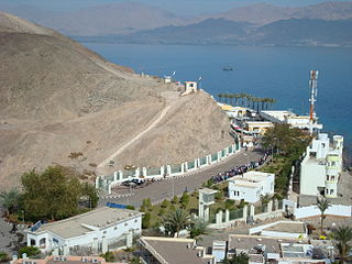
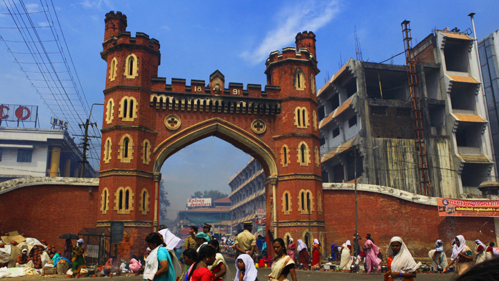
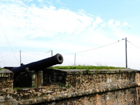
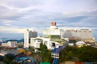
Taba
Taba is a small Egyptian town near the northern tip of the Gulf of Aqaba. It is the location of Egypt’s busiest border crossing with neighbouring Eilat, Israel. Despite it consisting of little more than a bus depot and a luxury hotel (complete with casino), it is a frequent vacation spot for Egyptians and tourists, especially those from Israel on their way to other destinations in Egypt or as a weekend getaway. It is the northernmost resort of Egypt’s Red Sea Riviera
History
Taba was located on the Egyptian side of the armistice line agreed to in 1949. During the Suez Crisis in 1956 it was briefly occupied but returned to Egypt when Israel withdrew in 1957. Israel reoccupied the Sinai Peninsula after the Six-Day War in 1967, and subsequently a 400-room hotel was built here. Following the 1973 Yom-Kippur War, when Egypt and Israel were negotiating the exact position of the border, Israel claimed that Taba had been on the Ottoman side of a border agreed between the Ottomans and British Egypt in 1906 and had, therefore, been in error in its two previous agreements. Although most of Sinai was returned to Egypt in 1982 following the 1979 peace treaty Taba was the last portion to be returned. After a long dispute, the issue was submitted to an international commission composed of one Israeli, one Egyptian, and three outsiders. In 1988, the commission ruled in Egypt’s favour, and Israel returned it to Egypt in February 1989.
As part of this subsequent agreement, travellers are permitted to cross from Israel at the Eilat – Taba border crossing, and visit the “Aqaba Coast Area of Sinai”, (stretching from Taba down to Sharm el Sheikh, and including Nuweiba, Saint Catherine’s Monastery and Dahab), visa-free for up to 14 days, making it a popular tourist destination. The resort community of Taba Heights is located some 20 km (12 mi) south of Taba. It features several large hotels, including The Hyatt Regency, Marriott, Sofitel and Intercontinental. It is also a significant diving area where many people come to either free dive, scuba dive or learn to dive via the many PADI courses on offer. Other recreation facilities include a new desert style golf course.
Source : wikipedia https://www.youtube.com/watch?v=x1_AjbF5C74 https://www.youtube.com/watch?v=8P_7FLbugTw
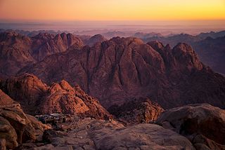
According to the Book of Exodus, Mount Sinai (Hebrew: הר סיני, Har Sinai) is the mountain at which the Ten Commandments were given to Moses by God. In the Book of Deuteronomy, these events are described as having transpired at Mount Horeb. “Sinai” and “Horeb” are generally considered to refer to the same place, although there is a small body of opinion that the two names may refer to different locations.
Hebrew Bible texts describe the theophany at Mount Sinai in terms which a minority of scholars, following Charles Beke (1873), have suggested may literally describe the mountain as a volcano and have led to a search for alternative locations.
Biblical description
According to the biblical account of the giving of the instructions and teachings of both the Written and the Oral Torah, Mount Sinai was enveloped in a cloud, it quaked and was filled with smoke, while lightning-flashes shot forth, and the roar of thunder mingled with the blasts of a trumpet; the account later adds that fire was seen burning at the summit of the mountain. In the biblical account, the fire and clouds are a direct consequence of the arrival of God upon the mountain. According to the biblical story, Moses departed to the mountain and stayed there for 40 days and nights in order to receive the Ten Commandments, the Written and the Oral Torah, and he did so twice because he broke the first set of the tablets of stone after returning from the mountain for the first time.
Source : wikipedia https://www.youtube.com/watch?v=yz69X6bkf6E https://www.youtube.com/watch?v=qnQ_tZDVr30 Reviews https://goo.gl/rCYfPM
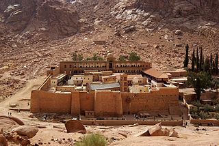
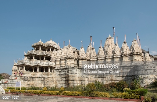
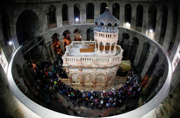
Saint Catherine’s Monastery, officially “Sacred Monastery of the God-Trodden Mount Sinai”, lies on the Sinai Peninsula, at the mouth of a gorge at the foot of Mount Sinai, in the city of Saint Catherine, Egypt in the South Sinai Governorate. The monastery is controlled by the autocephalous Church of Sinai, part of the wider Eastern Orthodox Church, and is a UNESCO World Heritage Site.
Built between 548 and 565, the monastery is one of the oldest working Christian monasteries in the world. The site contains the world’s oldest continually operating library, possessing many unique books including the Syriac Sinaiticus and, until 1859, the Codex Sinaiticus. A small town with hotels and swimming pools, called Saint Katherine City, has grown around the monastery.
Christian traditions
According to tradition, Catherine of Alexandria was a Christian martyr sentenced to death on the wheel. When this failed to kill her, she was beheaded. According to tradition, angels took her remains to Mount Sinai. Around the year 800, monks from the Sinai Monastery found her remains.
Although it is commonly known as Saint Catherine’s, the monastery’s full official name is the Sacred Monastery of the God-Trodden Mount Sinai. The patronal feast of the monastery is the Transfiguration. The monastery has become a favorite site of pilgrimage.
Manuscripts and icons
Saint Catherine’s Monastery library preserves the second largest collection of early codices and manuscripts in the world, outnumbered only by the Vatican Library. It contains Greek, Arabic, Armenian, Coptic, Hebrew, Georgian, and Aramaic texts.
In May 1844 and February 1859, Constantin von Tischendorf visited the monastery for research and discovered the Codex Sinaiticus, dating from the 4th Century, at the time the oldest almost completely preserved manuscript of the Bible. The finding from 1859 left the monastery in the 19th century for Russia, in circumstances that had been long disputed. But in 2003 Russian scholars discovered the donation act for the manuscript signed by the Council of Cairo Metochion and Archbishop Callistratus on 13 November 1869. The monastery received 9000 rubles as a gift from Tsar Alexander II of Russia. The Codex was sold by Stalin in 1933 to the British Museum and is now in the British Library, London, where it is on public display. Prior to September 1, 2009, a previously unseen fragment of Codex Sinaiticus was discovered in the monastery’s library.
In February 1892, Agnes Smith Lewis identified a palimpsest in St Catherine’s library that became known as the Syriac Sinaiticus and is still in the Monastery’s possession. Agnes and her sister Margaret Dunlop Gibson returned with a team of scholars that included J. Rendel Harris, to photograph and transcribe the work in its entirety. As the manuscript predates the Codex Sinaiticus, it became crucial in understanding the history of the New Testament.
The most important manuscripts have since been filmed or digitized, and so are accessible to scholars. A team of imaging scientists and scholars from the USA and Europe is using spectral imaging techniques developed for imaging the Archimedes Palimpsest to study more than one hundred palimpsests in the monastery library.
Works of art
The complex houses irreplaceable works of art: mosaics, the best collection of early icons in the world, many in encaustic, as well as liturgical objects, chalices and reliquaries, and church buildings. The large icon collection begins with a few dating to the 5th (possibly) and 6th centuries, which are unique survivals, the monastery having been untouched by Byzantine iconoclasm, and never sacked. The oldest icon on an Old Testament theme is also preserved there. A project to catalogue the collections has been ongoing since the 1960s. The monastery was an important centre for the development of the hybrid style of Crusader art, and still retains over 120 icons created in the style, by far the largest collection in existence. Many were evidently created by Latins, probably monks, based in or around the monastery in the 13th century.
Source : wikipedia https://www.youtube.com/watch?v=xVayV-OhYjU https://www.youtube.com/watch?v=1hEQAD5dCyY https://www.youtube.com/watch?v=ja55M3frdlQ Reviews https://goo.gl/a4PjmV
The burning bush is an object described by the Book of Exodus[3:1–4:17] as being located on Mount Horeb. According to the narrative, the bush was on fire, but was not consumed by the flames, hence the name. In the biblical narrative, the burning bush is the location at which Moses was appointed by Adonai (God) to lead the Israelites out of Egypt and into Canaan.
The Hebrew word used in the narrative, that is translated into English as bush, is seneh (סנה), which refers in particular to brambles; seneh is a biblical dis legomenon, only appearing in two places, both of which describe the burning bush. It is possible that the reference to a burning bush is based on a mistaken interpretation of Sinai (סיני), a mountain described by the Bible as being on fire. Another possibility is that the use of seneh (סנה) may be a deliberate pun on Sinai (סיני), a feature common in Hebrew texts.
Biblical narrative
In the narrative, an angel of the Lord is described as appearing in the bush, and God is subsequently described as calling out from it to Moses, who had been grazing Jethro’s flocks there. When Moses starts to approach, God tells Moses to take off his sandals first, due to the place being holy ground, and Moses hides his face.[9] Some Old Testament scholars regard the account of the burning bush as being spliced together from the Yahwist and Elohist texts, with the Angel of Adonai and the removal of sandals being part of the Yahwist version, and the Elohist’s parallels to these being God and the turning away of Moses’ face, respectively.
When challenged on his identity, Adonai replies that he is the God of the Patriarchs – Abraham, Isaac, and Jacob – and that he is Adonai. The text derives Yahweh (יהוה) from the Hebrew word hayah (היה) in the phrase ehyeh ašer ehyeh , meaning he who is he, or I am that I am;.
The text portrays Adonai as telling Moses that he is sending him to the Pharaoh in order to bring the Israelites out of Egypt, an action that Adonai is described as having decided upon as a result of noticing that the Israelites were being oppressed by the Egyptians. Yahweh tells Moses to tell the elders of the Israelites that Adonai would lead them into the land of the Canaanites, Hittites, Amorites, Hivites, and Jebusites, a region generally referred to as a whole by the term Canaan; this is described as being a land of milk and honey.
According to the narrative Adonai instructs Moses to confront the Egyptians and Israelites and briefs the prophet on what is to take place. Adonai then performs various demonstrative miracles in order to bolster Moses’ credibility. Among other things, his staff was transmuted into a snake, Moses’ hand was temporarily made leprous, and water was transmuted into blood, In the text, Yahweh instructs Moses to take this staff in his hands, in order to perform miracles with it, as if it is a staff given to him, rather than his own; some textual scholars propose that this latter instruction is the Elohist’s version of the more detailed earlier description, where Moses uses his own staff, which they attribute to the Yahwist.
Despite the signs, Moses is described as being very reluctant to take on the role, arguing that he lacked eloquence, and that someone else should be sent instead; in the text, Yahweh reacts by angrily rebuking Moses for presuming to lecture the One who made the mouth on who was qualified to speak and not to speak. Yet Yahweh concedes and allows Aaron to be sent to assist Moses, since Aaron is eloquent and was already on his way to meet Moses. This is the first time in the Torah that Aaron is mentioned, and here he is described as being Moses’ mouth piece.
Location
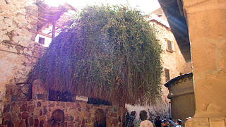
Christian hermits originally gathered at Mount Serbal, believing it to be the biblical Mount Sinai. However, in the 4th century, under the Byzantine Empire, the monastery built there was abandoned in favour of the newer belief that Mount Saint Catherine was the Biblical Mount Sinai; a new monastery – Saint Catherine’s Monastery was built at its foot, and the alleged site of the biblical burning bush was identified. The bush growing at the spot (a bramble, scientific name Rubus sanctus, was later transplanted several yards away to a courtyard of the monastery, and its original spot was covered by a chapel dedicated to the Annunciation, with a silver star marking where the roots of the bush had come out of the ground. The Monks at Saint Catherine’s Monastery, following church tradition, believe that this bush is, in fact, the original bush seen by Moses, rather than a later replacement, and anyone entering the chapel is required to remove their shoes, just as Moses was said to have done so in the biblical account.
However, in modern times, it is not Mount Saint Catherine, but the adjacent Jebel Musa (Mount Moses), which is currently identified as Mount Sinai by popular tradition and guide books; this identification arose from Bedouin tradition.
Mount Serbal, Mount Sinai, and Mount Saint Catherine, all lie at the southern tip of the Sinai peninsula, but the peninsula’s name is a comparatively modern invention, and it was not known by that name at the time of Josephus or earlier. Most modern scholars, as well as many modern theologians, dismiss the idea that the biblical Sinai was at the south of the peninsula, instead favouring locations in the Hijaz (at the north west of Saudi Arabia), northern Arabah (in the vicinity of Petra, or the surrounding area), or occasionally in the central or northern Sinai Peninsula. Hence, the majority of academics and theologians agree that if the burning bush ever existed, then it is highly unlikely to be the bush preserved at St Catherine’s Monastery.
Source : wikipedia https://www.youtube.com/watch?v=qLF-eRdbvzc https://www.youtube.com/watch?v=8dls_zF396w Reviews https://goo.gl/bSYD6A
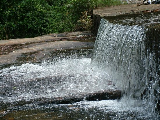
Moses Well
Image credit : pinterest.com
St Catherine’s Monastery also encompasses the Well of Moses, also known as the Well of Jethro, where Moses is said to have met his future wife, Zipporah.
As recounted in Exodus (2:15-21), Moses was resting by the well when the seven daughters of Jethro (also called Reuel) came to draw water. Some shepherds drove them away and Moses came to their defence.
In gratitude, Jethro invited Moses to his home and gave him his daughter Zipporah in marriage.
The well is still one of the monastery’s main sources of water.
Source : seetheholyland.net https://www.youtube.com/watch?v=LcKEV2cpa8M
The SUEZ CANAL (Egyptian Arabic: قناة السويس Kanāt El Sewēs) is an artificial sea-level waterway in Egypt, connecting the Mediterranean Sea to the Red Sea through the Isthmus of Suez. It was constructed by the Suez Canal Company between 1859 and 1869. After 10 years of construction, it was officially opened on November 17, 1869. The canal offers watercraft a shorter journey between the North Atlantic and northern Indian Oceans via the Mediterranean and Red seas by avoiding the South Atlantic and southern Indian oceans, in turn reducing the journey by approximately 7,000 kilometres (4,300 mi). It extends from the northern terminus of Port Said to the southern terminus of Port Tewfik at the city of Suez. Its length is 193.30 km (120.11 mi), including its northern and southern access channels. In 2012, 17,225 vessels traversed the canal (47 per day)
Source : wikipedia
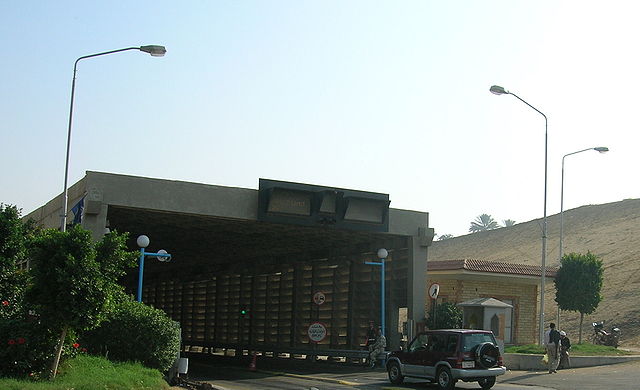
The AHMED HAMDI TUNNEL is 1640 meter long tunnel, for automobiles, under the Suez Canal, at Shallufa. The tunnel is named for Ahmed Hamdi, an Egyptian engineer and General killed in action during the Yom Kippur War. It has two lanes of traffic, one in each direction, and connects the Asian Sinai Peninsula to the town of Suez on the African mainland.
Ahmed Hamdi Tunnel was originally constructed as a shield tunnel by the Tarmac Construction in November 1981. In 1992, the Japanese government granted aid to a project aimed at rehabilitating the tunnel which had developed leaks. It is 1.63 km long and has an outside diameter of 11.6 m.
The tunnel was part of a major drive to develop the areas surrounding the Suez Canal, including other projects such as the Suez Canal overhead line crossing (completed in 1998), the El Ferdan Railway Bridge, and the Suez Canal Bridge (completed in 2001).
Source : wikipedia https://www.youtube.com/watch?v=Z-UqEDa5IBc https://www.youtube.com/watch?v=zxqwL2OIj-E
Cairo is the capital and largest city of Egypt. The city’s metropolitan area is the largest in the Middle East and the Arab world, and 15th-largest in the world, and is associated with ancient Egypt, as the famous Giza pyramid complex and the ancient city of Memphis are located in its geographical area. Located near the Nile Delta, modern Cairo was founded in 969 CE by Jawhar of the Fatimid dynasty, but the land composing the present-day city was the site of ancient national capitals whose remnants remain visible in parts of Old Cairo. It has long been a center of the region’s political and cultural life, and is titled “the city of a thousand minarets” for its preponderance of Islamic architecture.
It has the oldest and largest film and music industries in the Arab world, as well as the world’s second-oldest institution of higher learning, Al-Azhar University. Many international media, businesses, and organizations have regional headquarters in the city; the Arab League has had its headquarters in Cairo for most of its existence.
With a population of 6.76 million spread over 453 square kilometers (175 sq mi), it is by far the largest city in Egypt. An additional 9.5 million inhabitants live in close proximity to the city. It, like many other mega-cities, suffers from high levels of pollution and traffic. Cairo’s metro, one of only two in Africa (the other is in Algiers, Algeria), ranks among the fifteen busiest in the world, with over 1 billion annual passenger rides. The economy of Cairo was ranked first in the Middle East in 2005, and 43rd globally on Foreign Policy’s 2010 Global Cities Index.
Source : wikipedia https://www.youtube.com/watch?v=xZfoI92dWaI https://www.youtube.com/watch?v=eMro4Tuz4ZQ https://www.youtube.com/watch?v=Gog8rAqclPs
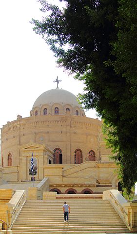
St. George Church Cairo is a Greek Orthodox church in Coptic Cairo. The church dates back to the 10th century (or earlier). The current structure was rebuilt following a 1904 fire. The church is one of the few round churches still in existence in the east. It is built atop an old Roman tower and adjoins the Monastery of St. George. The Holy family is said to have taken shelter in a place now covered by the church.There is a long set of steps that lead up to the church that are built on the outer wall of the Roman towers.As one ascend these steps, there can be found a relief of St. George and the dragon wrapped around the outer brickwork of the tower. The church had been burned many times. It burned in 1904 and the current structure was built in 1909, but still has some of the older structure’s beautiful stained-glass windows. For centuries, the church alternated between ownership by the Copts and the Greek, but since the 15th century it has remained Greek Orthodox
Sadly, the original Church of St. George that burned was considered one of the most beautiful and richest in the Roman fortress of Babylon. https://www.youtube.com/watch?v=suqjt-F_qRE https://www.youtube.com/watch?v=zOTPGhSE6uc Reviews https://goo.gl/tq0xNe
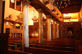
The Coptic Orthodox Church of St. Barbara (or Sitt Barbara) is one of the many famous Coptic Orthodox parishes that can be found in the district of Coptic Cairo. The building is located on the eastern part of the Babylon Fortress and is one of the oldest buildings in Cairo, dating back to the 5th or 6th century AD. However, like many other buildings of Coptic architecture, it was rebuilt several times, most notably by the end of the 11th Century.
History
St.Barbara Church Cairo stands north of the Coptic Museum and is east of the Church of Saints Sergius and Bacchus (Abu Serga), on the eastern side of Fort Babylon. It was originally dedicated to Abu Kir and Yohanna (or Ss. Cyrus and John). When the remains of St. Barbara were brought here, a separate sanctuary was built. Thus, there are now two separate churches that were built on this location. Athanasius, a wealthy scribe and a secretary of Abdel-Aziz Ibn Marwan (governor of Egypt between 685 and 705 AD), had built the Church. A door found during one of the church’s many restorations could date as early as the 4th Century. Between 1072 and 1073, the Church was fully restored to house the relics of Saint Barbara. These relics remain to this day. The Church was damaged again by another fire during the 12th century. In fact, the church was renovated as recently as the beginning of the 20th century, when the khurus, a transverse room preceding the sanctuary, was sacrificed in order to allow more space.
Architecture
The St.Barbara Church Cairo is known for its many precious items. These items were sent to the nearby Coptic Museum, which is only a two-minute walk from the church. The basilican structure and tripartite sanctuary of the church closely resembles the one of Abu Serga.
Nearby there is a convent which comprises several buildings, including a school built by the well known architect, Ramses Wissa Wassef.
While Saint Barbara’s Church has been a long-lasting example of ancient Coptic architecture, it resembles the shape of ancient Basilicas. It comprises an entrance, a narthex, a long nave, several aisles and three sanctuaries.
Like most other Coptic Orthodox churches that have more than one Sanctuary, the middle sanctuary is the one of main importance, dedicated to St. Barbara. After entering, from the narthex’s lobby, there are five marble columns that separate the nave from the two aisles. In front of the middle sanctuary there is a semi-circular choir, which consists of 7 large steps.
There are several other icons on the southern aisle of the church, representing the Virgin Mary and Jesus when he was a child, Jesus entering Jerusalem and the baptism of Christ.
Source : wikipedia https://www.youtube.com/watch?v=zjJKqs7Vu_M https://www.youtube.com/watch?v=GEi2zO0OIk0 Reviews https://goo.gl/p3hydW
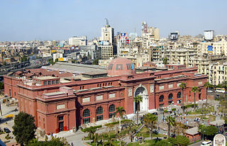
The Museum of Egyptian Antiquities, known commonly as the Egyptian Museum or Museum of Cairo, in Cairo, Egypt, is home to an extensive collection of ancient Egyptian antiquities. It has 120,000 items, with a representative amount on display, the remainder in storerooms. The edifice is one of the largest museums in the region. As of February 2017, the museum is open to the public.
History
The Egyptian Museum of Antiquities contains many important pieces of ancient Egyptian history. It houses the world’s largest collection of Pharaonic antiquities. The Egyptian government established the museum, built in 1835 near the Ezbekeyah Garden and later moved to the Cairo Citadel. In 1855 Archduke Maximilian of Austria was given all of the artifacts by the Egyptian government; these are now in the Kunsthistorisches Museum, Vienna.
A new museum was established at Boulaq in 1858 in a former warehouse, following the foundation of the new Antiquities Department under the direction of Auguste Mariette. The building lay on the bank of the Nile River, and in 1878 it suffered significant damage in a flood of the Nile River. In 1891, the collections were moved to a former royal palace, in the Giza district of Cairo. They remained there until 1902 when they were moved, for the last time, to the current museum in Tahrir Square.
During the Egyptian Revolution of 2011, the museum was broken into, and two mummies were destroyed. Several artifacts were also shown to have been damaged. Around 50 objects were lost. Since then 25 objects have been found. Those that were restored were put on display in September 2013 in an exhibition entitled Damaged and Restored. Among the displayed artifacts are two statues of King Tutankhamun made of cedar wood and covered with gold, a statue of King Akhenaten, ushabti statues that belonged to the Nubian kings, a mummy of a child and a small polychrome glass vase.
Interior design
There are two main floors in the museum, the ground floor and the first floor. On the ground floor there is an extensive collection of papyrus and coins used in the Ancient world. The numerous pieces of papyrus are generally small fragments, due to their decay over the past two millennia. Several languages are found on these pieces, including Greek, Latin, Arabic, and ancient Egyptian. The coins found on this floor are made of many different metals, including gold, silver, and bronze. The coins are not only Egyptian, but also Greek, Roman, and Islamic. This has helped historians research the history of Ancient Egyptian trade.
Also on the ground floor are artifacts from the New Kingdom, the time period between 1550 and 1069 BC. These artifacts are generally larger than items created in earlier centuries. Those items include statues, tables, and coffins (sarcophagi), it also contains 42 rooms, upon entering through the security check in the building, one looks toward the atrium and the rear of the building with many items on view from sarcophagi and boats to enormous statues.
On the first floor there are artifacts from the final two dynasties of Egypt, including items from the tombs of the Pharaohs Thutmosis III, Thutmosis IV, Amenophis II, Hatshepsut, and the courtier Maiherpri, as well as many artifacts from the Valley of the Kings, in particular the material from the intact tombs of Tutankhamun and Psusennes I. Two special rooms contain a number of mummies of kings and other royal family members of the New Kingdom.
Source : wikipedia https://www.youtube.com/watch?v=oQeg3dAZRqc https://www.youtube.com/watch?v=ZdLza2Y0sKM https://www.youtube.com/watch?v=PQFT4lpeQ44 Reviews https://goo.gl/oHdG5g
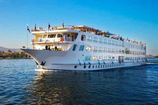
Before leaving Cairo after the holidays it is a must experience a Nile River dinner cruise. The Cruise starts at 06.30 pm and ends by 08.30pm.
A night spent on the Nile or at least an evening seems to be a must for every tourist. A number of floating restaurants in Cairo respond to this desire and offer a special nightlife experience. All of them entertain their guests with more than only with a luxurious dinner. This is a splendid way to see the Nile and city skyline at its best. Few can complete with the romantic setting of dinner on a Nile cruise ship. These cruisers float for 2 hours and bring you and your party tasty meals, excellent entertainment and an unforgettable evening of stargazing along the Nile banks. The tour includes belly dance shows and live music of all styles, Arabic as well as Western, and Sufi or even acrobatic performances.
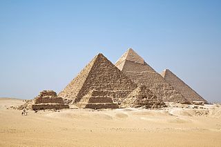
The Egyptian pyramids are ancient pyramid-shaped masonry structures located in Egypt.
As of November 2008, sources cite either 118 or 138 as the number of identified Egyptian pyramids. Most were built as tombs for the country’s pharaohs and their consorts during the Old and Middle Kingdom periods.
The earliest known Egyptian pyramids are found at Saqqara, northwest of Memphis. The earliest among these is the Pyramid of Djoser (constructed 2630 BC–2611 BC) which was built during the third dynasty. This pyramid and its surrounding complex were designed by the architect Imhotep, and are generally considered to be the world’s oldest monumental structures constructed of dressed masonry.
The most famous Egyptian pyramids are those found at Giza, on the outskirts of Cairo. Several of the Giza pyramids are counted among the largest structures ever built. The Pyramid of Khufu at Giza is the largest Egyptian pyramid. It is the only one of the Seven Wonders of the Ancient World still in existence.
Historical development
By the time of the Early Dynastic Period, those with sufficient means were buried in bench-like structures known as mastabas.
The second historically-documented Egyptian pyramid is attributed to the architect Imhotep, who planned what Egyptologists believe to be a tomb for the pharaoh Djoser. Imhotep is credited with being the first to conceive the notion of stacking mastabas on top of each other, creating an edifice composed of a number of “steps” that decreased in size towards its apex. The result was the Pyramid of Djoser, which was designed to serve as a gigantic stairway by which the soul of the deceased pharaoh could ascend to the heavens. Such was the importance of Imhotep’s achievement that he was deified by later Egyptians.
The most prolific pyramid-building phase coincided with the greatest degree of absolutist rule. It was during this time that the most famous pyramids, the Giza pyramid complex, were built. Over time, as authority became less centralized, the ability and willingness to harness the resources required for construction on a massive scale decreased, and later pyramids were smaller, less well-built and often hastily constructed.
Long after the end of Egypt’s own pyramid-building period, a burst of pyramid-building occurred in what is present-day Sudan, after much of Egypt came under the rule of the kings of Napata. While Napatan rule was brief, ending in 661 BC, Egyptian culture made an indelible impression, and during the later Kingdom of Meroë (approximately in the period between 300 BCE – 300 CE), this flowered into a full-blown pyramid-building revival, which saw more than two hundred Egyptian-inspired indigenous royal pyramid-tombs constructed in the vicinity of the kingdom’s capital cities.
Al-Aziz Uthman (1171–1198) tried to destroy the Giza pyramid complex. He gave up after damaging the Pyramid of Menkaure because the task proved too huge.
Source : wikipedia https://www.youtube.com/watch?v=BdALkK2yDEE https://www.youtube.com/watch?v=ZC4U-2ntAGA https://www.youtube.com/watch?v=9_9BMJpOzLo Reviews https://goo.gl/K52WRP
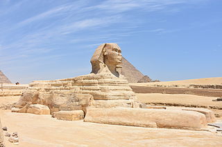
A sphinx is a mythical creature with the head of a human and the body of a lion.
In Greek tradition, it has the head of a human, the haunches of a lion, and sometimes the wings of a bird. It is mythicised as treacherous and merciless. Those who cannot answer its riddle suffer a fate typical in such mythological stories, as they are killed and eaten by this ravenous monster. This deadly version of a sphinx appears in the myth and drama of Oedipus. Unlike the Greek sphinx, which was a woman, the Egyptian sphinx is typically shown as a man (an androsphinx). In addition, the Egyptian sphinx was viewed as benevolent, but having a ferocious strength similar to the malevolent Greek version and both were thought of as guardians often flanking the entrances to temples.
The largest and most famous sphinx is the Great Sphinx of Giza, situated on the Giza Plateau adjacent to the Great Pyramids of Giza on the west bank of the Nile River and facing east. It is located southeast of the pyramids. Although the date of its construction is uncertain, the head of the Great Sphinx now is believed to be that of the pharaoh Khafra.
What names their builders gave to these statues is not known. At the Great Sphinx site, a 1400 BCE inscription on a stele belonging to the 18th dynasty pharaoh Thutmose IV lists the names of three aspects of the local sun deity of that period, Khepera–Rê–Atum. The inclusion of these figures in tomb and temple complexes quickly became traditional and many pharaohs had their heads carved atop the guardian statues for their tombs to show their close relationship with the powerful solar deity, Sekhmet, a lioness. Other famous Egyptian sphinxes include one bearing the head of the pharaoh Hatshepsut, with her likeness carved in granite, which is now in the Metropolitan Museum of Art in New York, and the alabaster sphinx of Memphis, Memphis, Egypt, currently located within the open-air museum at that site. The theme was expanded to form great avenues of guardian sphinxes lining the approaches to tombs and temples as well as serving as details atop the posts of flights of stairs to very grand complexes. Nine hundred with ram heads, representing Amon, were built in Thebes, where his cult was strongest.
Perhaps the first sphinx in Egypt was one depicting Queen Hetepheres II, of the fourth dynasty that lasted from 2723 BCE to 2563. She was one of the longest-lived members of the royal family of that dynasty.
Source : wikipedia https://www.youtube.com/watch?v=y8x7zKy2U5E https://www.youtube.com/watch?v=or-6ulewzaU Reviews https://goo.gl/6cKJAK
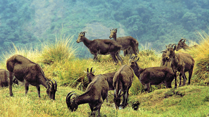
India has maintained a list of tentative sites in which Desert National Park is also included for recognition which has been submitted to UNESCO Committee for evaluation and acceptance.
Desert National Park, Rajasthan, India, is situated in the west Indian state of Rajasthan near the town of Jaisalmer. This is one of the largest national parks, covering an area of 3162 km². The Desert National Park is an excellent example of the ecosystem of the Thar Desert. Sand dunes form around 20% of the Park. The major landform consists of craggy rocks and compact salt lake bottoms, intermedial areas and fixed dunes.
Despite a fragile ecosystem there is an abundance of birdlife. The region is a haven for migratory and resident birds of the desert. Many eagles, harriers, falcons ,buzzards, kestrel and vultures. Short-toed eagles, tawny eagles, spotted eagles, laggar falcons and kestrels are the most common among these. Sand grouse are spotted near small ponds or lakes. The endangered great Indian bustard is a magnificent bird found in relatively fair numbers. It migrates locally in different seasons. The most suitable time to visit the area is between November and January. The Desert National Park has a collection of fossils of animals and plants of 180 million years old. Some fossils of dinosaurs of 6 million years old have been found in the area.
Attractions Indian bustard: The endangered Indian bustard is the major attraction of Desert National Park. Brown and white in colour, the bustard is a metre tall and has long bare legs and a long neck. One can spot this tall and graceful ground-dwelling bird near the Sudashri waterhole. Sam Sand Dunes:
These dunes are located near the Thar Desert.
Gadsisar Sagar Tank:
This tank is among the tourist places in Jaisalmer, Rajasthan. Thousands of migratory birds come to this place every year.
Tourism
Jeep Safari enables tourists to explore a wider area of the park in relatively short span of time.
The park is open throughout the year, but the ideal time to visit is from October to February. At this time, the maximum temperature is 20 degrees Celsius and the minimum around 6 degrees Celsius.
Devikulam Lake now known as Sita Devi Lake is located about 5 kilometres (3.1 mi) from Munnar in the Idukki District. It lies 1,800 metres (5,900 ft) above sea level.
According to legend, the goddess Sita Devi of the Ramayana epic bathed in the beautiful Devikulam lake waters surrounded by lush, green hills, now named Sita Devi Lake. The lake draws tourists not only because of its sacredness but also for the curative powers of its mineral waters. Most of the inhabitants in this town speak Malayalam and Tamil. Nearby, are the scenic Pallivasal Waterfalls, dense, green tea plantations, and the natural vegetation of slim red and blue and yellow gum trees.
The settlement had a population of approximately 350 people as of 2010
Source : wikipedia Reviews https://goo.gl/1Ah0sF
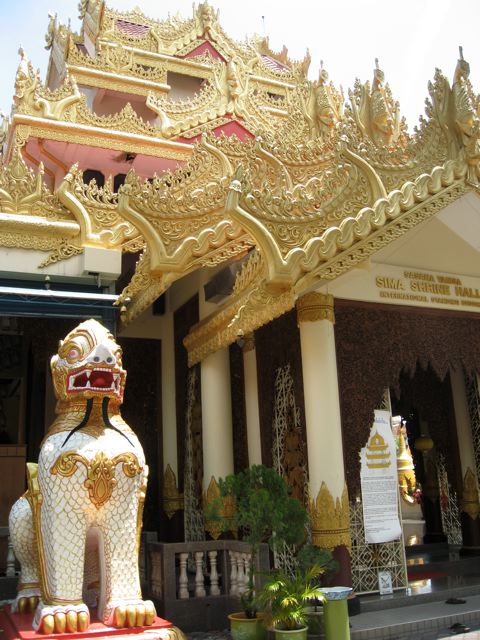
The Dhammikarama Burmese Buddhist Temple is situated along Burma Lane in Pulau Tikus and was founded on 1st August 1803, the temple was known as “Nandy Moloh Burmese Temple” then. This place of public worship was purchased by Nonya Betong from George Layton, granted by Sir George Leith Baronet, LT. Governer of Prince of Wales Island, for 390 Spanish Dollars and donated to the temple.
Being one of the earliest and the only Burmese Temple in Malaysia and featuring the historical pagoda, the temple’s well and Sima hall, the temple was designated in 1988 as one of the state’s historical sites to be preserved as a tourist attraction.
The Dhammikarama Burmese Buddhist Temple is always managed by a Chief Monk to facilitate and complement the practice of Buddhism, the temple has a main shrine hall, a sima hall, a dining hall, monk’s quarters, preceptee’s lodge, Sunday school, a library and a lecture hall. The first Chief Monk of the temple was Venerable U. Nandamala
The Dhammikarama Burmese Buddhist Temple has been identified as one of the fifteen historical sites to be launched under the visit Penang year 1988 in the state of Penang. The temple grounds which is renowned for its green and serene environment, had participated and was awarded the 1st prize in the state landscaping and beautification programme held in 1997 and 2001.
This world Guardian and Protector is unique as it is rare. It possesses the quality of the five best combination such as the trunk and tusks of the elephant, four hoofed legs and two agile ears of the horse, the lion-faced toe (chimera), the deer’s horn, the body and tail of the fish and the two powerful wings of the Roe (Garuda). Therefore it is ideally suited for its role of guarding the world in the form of the globe.
The Arahant Upagutta Shrine, originally a small plank building, was constructed in 1840 on the present site. The new shrine was constructed in 1976 and the Arahant Upagutta Image was consecrated on 18th December 1978. Arahant Upagutta is stated to posses the power to overcome all obstacles, problems, fulfilling of wishes (examinations, sickness, etc.) and also the exorcising of evil.
Getting there To get to Dharmikarama Burmese Temple from Komtar or Lebuh Chulia, is to hop on board TransitLink bus #202, Minibus 26, 31 and 88 or Hin Bus #93.
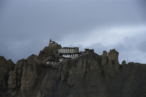
Dhankar Gompa (also Dankhar, Drangkhar or Dhangkar Gompa; Brang-mkhar or Grang-mkhar) is village and also a Gompa, a Buddhist temple in the district of Lahaul and spiti in India. It is situated at an elevation of 3,894 metres (12,774 feet) in the Spiti Valley above Dhankar Village, between the towns of Kaza and Tabo. The complex is built on a 1000-foot (300-metre) high spur overlooking the confluence of the Spiti and Pin Rivers – one of the world’s most spectacular settings for a gompa. Dhang or dangmeans cliff, and kar or khar means fort. Hence Dhangkar means fort on a cliff.
Dhankar, like Key Monastery and Tangyud Monastery in Spiti, and Thiktse, Likir and Rangdum monasteries in Ladakh, was built as a fort monastery on the Central Tibetan pattern. It was reported to have had 90 monks in 1855.
Below the Gompa lies the small village of Shichilling which contains the new Dhankar Monastery, home to about 150 monks belonging to the Gelug school of Tibetan Buddhism.
Beyond the surrounding harsh, lunar landscape, notable sights at Dhankar Gompa include a statue of Vairocana consisting of four figures seated back-to-back, in addition to various crumbling thangkas.
There is a small museum in the gompa. In 2006, World Monuments fund selected Dhankar gompa as one of the 100 most endangered sites in the world. A nonprofit group, Dhangkar Initiative, is attempting to organize its conservation.
Dhankar is approachable by a motorable road, good for small vehicles only, that branches off for Dhankar from the main Kaza-Samdu road at a point around 24 km from Kaza. The branch road is 8 km in length up to Dhankar.
Dhoni is situated around 15 Kilometers from Palakkad town in Kerala, India. Dhoni is named after a boat shaped rock on one of its hill, as boat in Malayalam is called “thoni”. It is famous for Dhoni Waterfalls and the Western Ghat forests. Dhoni is bordered by Western Ghats on north. It is also a popular trekking spot for tourists. Dhoni farm is situated at Dhoni.
Dhoni Waterfalls is located around 15 km from Palakkad and around 34 km from Kollengode Town in Palakkad. An entry pass is required before entering the area. A fee of Rs.100/- (from 15 August 2016) will be charged per person. You have to walk 4 km from the bottom of the hill to reach the waterfalls. The roads are not tarred, and one can see water flowing down between the rocks on the way up. No restrictions for carrying food to the top.
The Dilwara Jain Temples of India are located about 2½ kilometres from Mount Abu, Rajasthan’s only hill station. Dilwara Jain Temples were built by Vastupal-Tejpal, a Jain laymen between the 11th and 13th centuries AD and are world famous for their stunning use of marble. The five legendary marble temples of Dilwara are a sacred pilgrimage place of the Jains. Some consider them to be one of the most beautiful Jain pilgrimage sites in the world. The marble temples have an opulent entranceway, the simplicity in architecture reflecting Jain values like honesty and frugality. The Dilwara Jain Temples are in the midst of a range of forested hills. A high wall shrouds the temple complex.
Although the Jains built some beautiful temples at other places in Rajasthan, some believe that none come close to these in terms of architectural perfection. The ornamental detail spreading over the minutely carved ceilings, doorways, pillars and panels is simply marvellous.
Facilities are available for bathing, which is mandatory before puja is performed for the idols. These facilities use passive solar power to heat up the water for bathing and other things. Guided tour hours for tourists are posted outside the temple.
There are five temples in all, each with its own unique identity. Each is named after the small village in which it is located. These are:
Vimal Vasahi, dedicated to the first Jain Tirthankara, Rishabha.
Luna Vasahi, dedicated to the 22nd Jain Tirthankara, Neminatha.
Pithalhar, dedicated to the first Jain Tirthankar, Rishabha.
Parshvanath, dedicated to the 23rd Jain Tirthankara, Parshvanatha.
Mahavir Swami, dedicated to the last Jain Tirthankara, Mahavira.
The most famous of these are the Vimal Vasahi and Luna Vasahi temples.
Vimal Vasahi Temple
Image Credit : templesofindia.net
This temple carved entirely out of white marble was built in 1031 A.D. by Vimal Shah, a minister of Bhimdev I, the Chalukya King (Solanki Maharaja) of Gujarat. The temple is dedicated to Lord Rishabha. The temple stands in an open courtyard surrounded by a corridor, which has numerous cells containing smaller idols of the tirthankaras. The richly carved corridors, pillars, arches, and ‘mandaps ‘ or porticoes of the temple are simply amazing. The ceilings feature engraved designs of lotus-buds, petals, flowers and scenes from Jain mythology.
The Rang mandap is a grand hall supported by 12 decorated pillars and nicely carved out arches with a breathtaking central dome. On the pillars are carved female figurines playing musical instruments and 16 Vidhyadevis, or the goddesses of knowledge, each one holding her own symbol.
The Navchowki is a collection of nine rectangular ceilings, each one containing beautiful carvings of different designs supported on ornate pillars. The Gudh mandap is a simple hall once you step inside its heavily decorated doorway. Installed here is the idol of Adi Nath or Lord Rishabdev, as he is also known. The mandap is meant for Aarti to the deity. The Hastishala (Elephant Cell) was constructed by Prithvipal, a descendant of Vimal Shah in 1147-49 and features a row of elephants in sculpture.
Luna Vasahi
Image credit : commons.wikimedia.org
The Luna Vashi temple is dedicated to Lord Neminath. This magnificent temple was built in 1230 by two Porwad brothers – Vastupal and Tejpal – both ministers of a Virdhaval, the Vaghela ruler of Gujarat. The temple built in memory of their late brother Luna was designed after the Vimal Vashi temple. The main hall or Rang mandap features a central dome from which hangs a big ornamental pendent featuring elaborate carving. Arranged in a circular band are 72 figures of Tirthankars in sitting posture and just below this band are 360 small figures of Jain monks in another circular band. The Hathishala or elephant cell features 10 beautiful marble elephants neatly polished and realistically modelled.
The Navchowki features some of the most magnificent and delicate marble stone cutting work of the temple. Each of the nine ceilings here seems to exceed the others in beauty and grace. The Gudh mandap features a black marble idol of the 22nd tirthankar Neminatha. The Kirthi Stambha is a big black stone pillar that stands on the left side of the temple. The pillar was constructed by Maharana Kumbha of Meawr. The remaining three temples of Dilwara are smaller but just as elegant as the other two.
The temple is open for non-Jain visitors from noon to 6 pm (Jain visitors can visit from sunrise to sunset). Photography is not allowed inside the temple premises and bags are searched to prevent cameras being taken in. as at other Jain temples, all articles of leather have to be left at the entrance (where you pay a few rupees when collecting them). You can stroll out to Dilwara from the town in less than an hour, or can get a shared taxi from opposite of Madras Cafe, in the center of the town.
Do you often feel that you are stuck with your boring 9 to 5 job ?
Do you think you are missing a lot of opportunities for making money online?
Do you always struggle to raise that extra money for your dream vacation?
Do you have difficulty in earning extra income?
If your answer is YES for any of these, then this blog post is for you.
I am here to help you make a plan that you can use to make a steady flow of extra income.
The trick here is to continue the way you are doing now. Don’t change anything at this point of time………………………………………………………………………………………………..
64-1550 Kamehameha Hwy.
Wahiawa, Hawaii 96786
Phone : 808-621-8408
This photo of Royal Star Hawaii Deluxe Tours is courtesy of TripAdvisor
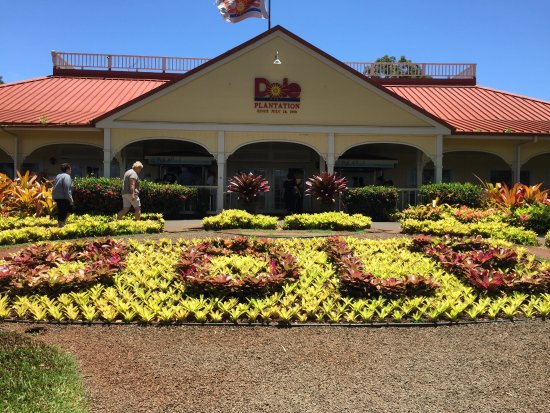
Originally operated as a fruit stand beginning in 1950, Dole Plantation opened to the public as Hawaii’s “Pineapple Experience” in 1989. Today, It is one of Oahu’s most popular visitor attractions and welcomes more than one million visitors a year.
Dole Plantation provides enjoyable activities for the entire family, including the Pineapple Express Train Tour, the Plantation Garden Tour, and the Pineapple Garden Maze. Also popular are informational displays and presentations, as well as our plantation country store offering a wide variety of Dole Plantation gifts, local favorites, foods and refreshments including the world-famous DoleWhip®. And, before you leave you can purchase fresh pineapple to take home.
Admission to the Plantation grounds is free, and there are also plenty of free activities, including a pineapple cutting demonstration and a fish-feeding pond.
The Plantation is open daily from 9:30 a.m. to 5:30 p.m. (tours and attractions close at 5:00 p.m.) and is closed on Christmas Day.
Source : https://bit.ly/2diPv6s For details of tours and Tickets https://bit.ly/2uDnccS https://www.youtube.com/watch?v=8RtXyIA28MM https://www.youtube.com/watch?v=S3nrsZ5AGVU Reviews https://bit.ly/2LjcT4G
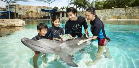
Meet the magnificent Indo-Pacific bottlenose dolphins – some of the most fascinating marine mammals of the oceans! Dolphin Island offers a range of programmes that will give you the opportunity to meet them up-close.
The unique programmes give you the chance to interact with the dolphins, which will be an unforgettable experience. More importantly, it will inspire visitors to a deeper understanding of marine life, and to discover more about dolphins through “engagement learning”. The marine mammal trainers and hosts will share knowledge about dolphins, their habitats, diets, anatomies and migration patterns.
They will also share what they are doing in the areas of research and veterinary care to give you an idea of what’s being done to protect the dolphins.
Arrange your interaction session to learn more about the dolphins today!
Admission
Dolphin Discovery – $98/Adult
Dolphin Encounter – $68/Adult
Dolphin Trek – $98/Adult
Dolphin Adventure – $128/Adult
Dolphin Observer – $58/Adult
Dolphin VIP – $288/Adult
Trainer for a Day – $398/Adult
All Dolphin Island interaction programmes include:
One-day pass to Adventure Cove Waterpark™
Getting There
By Sentosa Express: Alight at WaterFront Station
By Bus:
– Sentosa Bus 1 or Bus 2 and alight at Resorts World Sentosa (Basement 1)
– RWS 8 and alight at RWS 8 bus stop outside The Forum, Sentosa
By Foot: Take a stroll down the Sentosa Boardwalk to Resorts World Sentosa
Estr. Mirante Dona Marta, S/N – Santa Teresa,
Rio de Janeiro, Brazil
Image Credit : Tripadvisor
Who does not like to visit a lookout point which has a magnificent view? Known as the Marvelous City, the Rio de Janeiro has several lookouts to enjoy its beauties. So check this peak we’ll show you. Dona Marta Viewpoint is a magnificent tour with a stunning look that always yields great moments and beautiful photos. Best of all is that the access is easy (no need hike) and the entrance is free!
Situated 364 meters above sea level, well on top of the pacified favela of Santa Marta, the view from Dona Marta Viewpoint is as impressive as the view of Christ the Redeemer Statue. To be honest, it’s one of the most beautiful views of Rio de Janeiro. With its privileged geographical position, it has a detailed look of the Marvelous City. incredible scenery as Urca, Botafogo and Flamengo beaches, Sugar Loaf, Maracana, Christ the Redeemer Statue and the Bay of Guanabara, are revealed from the top of Dona Marta lookout.
Dream Land Munnar is a fun place with lot of activities and rides to keep the entire family busy all day along. Munnar, one of the best tourist destinations in Kerala, is not really known for adventure sports. But if you are keen on some high energy activities in the lap of the nature, you won’t be disappointed. Dream Land Spices Park is a place with full of energy and fun. It’s an activity park setup in a tea plantation with lot of fun rides and activities to keep the entire family busy all day.
The park is located near Anachal, a little off the main road from Adimali to Munnar. The parking area and ticket counter are on the highest elevation of the park. Once we exit from the ticket counter, we will see the beautifully landscaped tea plantation. Rides & Activities Children Rides :https://goo.gl/A1XbXM Youth Rides :https://goo.gl/ZdxKnZ Family Rides :https://goo.gl/tWBGJU Off Road Rides :https://goo.gl/zuLZuc Horror House :https://goo.gl/rdcqqf https://www.youtube.com/watch?v=2CcmjyM2IsE https://www.youtube.com/watch?v=rIsPMcjNfFo Reviews https://goo.gl/XbCQPk
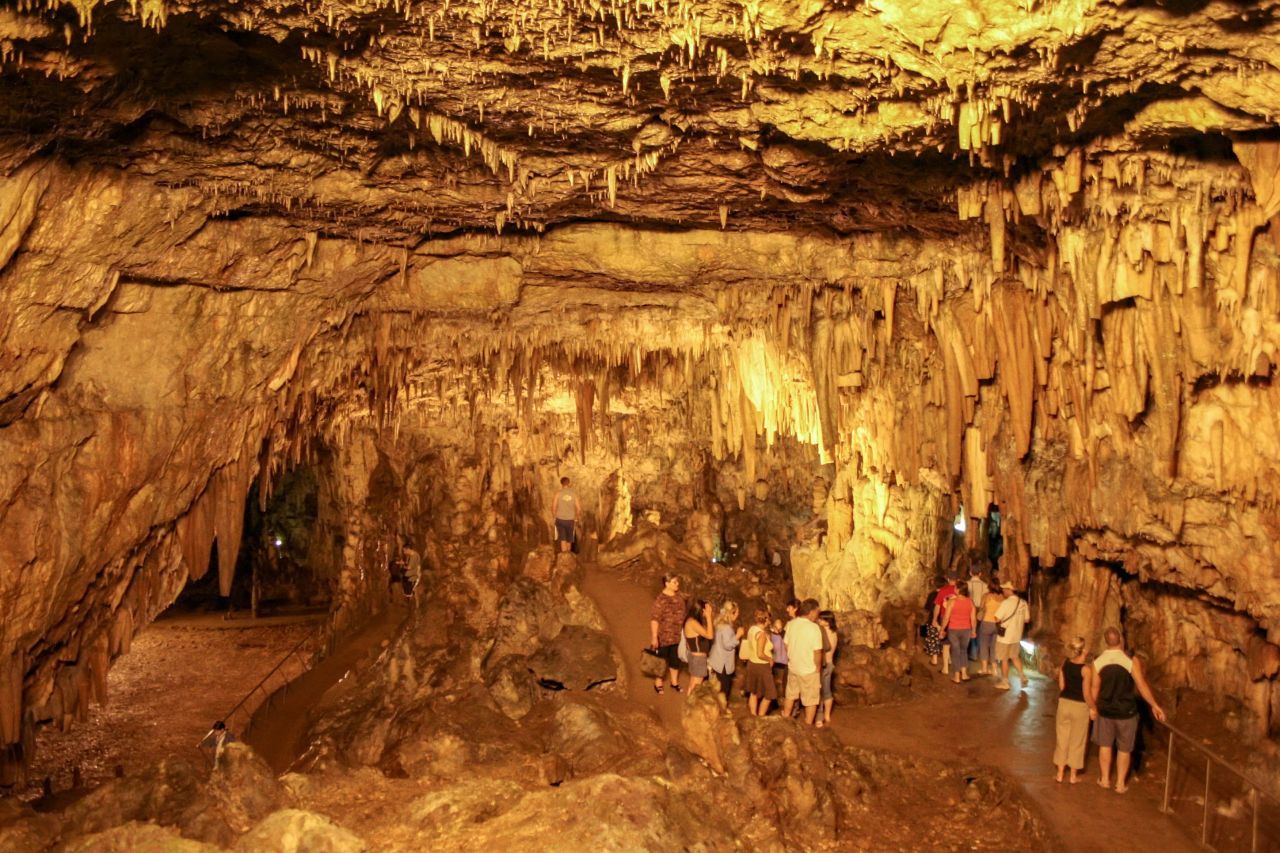
The Drogarati Cave in Kefalonia: The Drogarati Cave in Kefalonia was discovered 300 years ago and opened to the public in 1963. It was discovered when a strong earthquake caused a collapse that revealed the cave’s entrance. Drogarati is an impressive cave with remarkable formations of stalactites and stalagmites. Speleologists say that this cave is about 150 million years old and constitutes a rare geological phenomenon. The cave is about 60m deep and has a constant temperature of 18ΊC. The humidity of the cave reaches 90%.
Although it has undergone many damages because of earthquakes, stalactites still hang from the roof and form amazing shapes. As water drops fall onto these shapes and solidify, they give them another shape, long but gradually along centuries.
Drogarati Cave consists of two parts. The part accessible to tourists consists of a long corridor that leads to the Royal Balcony, a natural platform of stalactites that beautifully reflect the light. From there, the visitor can see the Chamber of Exaltation, which has great acoustics. This chamber is the biggest hall of the cave; it is sometimes used to host cultural events and has a room for 500 people. To move from one part to the other, you cross colored columns and a small lake.
Scientists have discovered that Drogarati cave has an extension that is not reachable and believes that, through this extension, it is connected to other sea caves. Drogarati Cave is, therefore, a natural art masterpiece that has taken its present form after thousands of years, while it continually changes. It is visited by lots of tourists every year and can be found 5 km to the south of Sami village, on the eastern coast of Kefalonia and right on the main road that connects Sami to Argostoli.
Source : Greeka.com
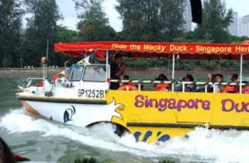
There is no better way to tour Singapore than catching a ride on the ORIGINAL DUCK tours! Embark on a land and sea adventure on a remodeled WWII amphibious Vietnamese war craft that promises you the best tour experience. This hour-long journey brings you up close to Singapore’s famous skyline, historical landmarks and gorgeous bay view.
DUCK & HiPPO is a group of crazy (in a good way) people; committed to bringing a smile to every guest we serve. Work and play are just seriously fun (oxymoron, yes, we know) and that is us. We thrive on laughter, friendship and cheer and we hope to make your journey with us an unforgettable one.
Home-grown and 100% Singaporean, DUCK & HiPPO is an active and innovative player in the tourism industry. We are Singapore’s original DUCKtours and topless tour bus operator, while others can only follow and copy. Our core tour products are testimonies to our wacky nature – the amphibious DUCKtours and HiPPO topless buses. We are interested in delivering anything which is out-of-the-box and totally unorthodox, so the list will just keep growing!
Winner of the Tourism Awards Singapore, DUCK tours is rated as one of the Top 10 Best Family Experiences! An adventure and thrill ride all in one, ride the original Wacky DUCK now!
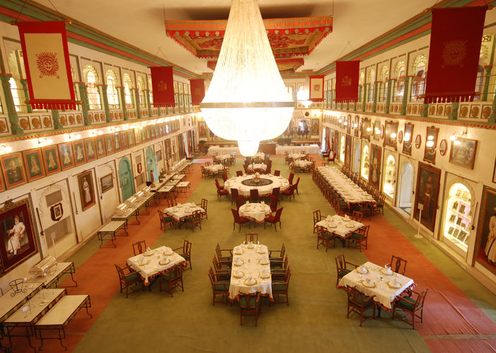
Durbar Hall was built in 1909 within the Fatehpraksh Palace as a venue for official functions such as State banquets and meetings .The gallery of the hall was used by the Royal ladies to observe the Durbar proceedings. This hall has a luxuriant interior with large chandeliers. Weapons of the maharanas and some of their portraits are depicted here. The foundation stone for this hall was laid by Lord Minto, the Viceroy of India, in 1909, during the rule of Maharana Fateh Singh and was then called Minto Hall.
The Durbar Hall is among the most grand of all in Udaipur and even among the various Durbar Halls across other palaces in India.
From the galleries that surround the The Durbar Hall, one gets a magnificent view of the Lake Pichola, Jagmandir Island Palace, Lake Palace and the Sajjangarh Palace. The Durbar Hall is a glorious venue for conferences, celebratory dinners and banquets. Multi-cuisine buffets or sit-down dinners can best be organised here to complement a Regal Wedding in Udaipur. Musical soirees and performances can also be organised.
The arched gallery of the The Durbar Hall Sabhagaar, on the first floor, houses the famous Crystal Gallery, probably the largest single private collection of crystal anywhere in the world.
Mattancherry, Kochi, Kerala 682002
Phone: 0484 606 8716
Image credit : keralatourism.org
The Mattancherry Palace is a Portuguese palace popularly known as the Dutch Palace, in Mattancherry, Kochi, in the Indian state of Kerala which features Kerala murals depicting portraits and exhibits of the Rajas of Kochi.
History
The Mattancherry Palace was built and gifted by the Portuguese as a present to the king of Cochin around 1555. The Dutch carried out some extensions and renovations in the palace in 1663, and thereafter it was popularly called Dutch Palace. The rajas also made more improvements to it. Today, it is a portrait gallery of the Cochin Rajas and notable for some of the best mythological murals in India, which are in the best traditions of Hindu temple art. The palace was built to appease the king after they plundered a temple nearby.
The landing of Vasco da Gama, the Portuguese explorer at Kappad in 1498 was welcomed by the Kochi rulers. They were given exclusive right to construct factories. The Portuguese repulsed the repeated attacks of the Zamorians and the Cochin Rajas practically became vassals of the Portuguese. The influence of the Portuguese were supplanted by the Dutch and they took over Mattancherry in 1663. Subsequently, the area was taken over by Hyder Ali and still later by the British East India Company
The Palace
The Mattancherry palace is a quadrangular structure built in Nālukettu style, the traditional Kerala style of architecture, with a courtyard in the middle. In the courtyard there stands a small temple dedicated to ‘Pazhayannur Bhagavati’, the protective goddess of the Kochi royal family. There are two more temples on either side of the Palace, one dedicated to Lord Krishna and the other to Lord Siva. Certain elements of architecture, as for example the nature of its arches and the proportion of its chambers are indicative of European influence in basic Nālukettu style.
The Dining Hall has carved wooden ornate ceiling decorated with a series of brass cups. The palace also contains rare examples of traditional Kerala flooring, which looks like polished black marble but is actually a mixture of burned coconut shells, charcoal, lime, plant juices and egg whites.
Murals
The glory of the Mattancherry palace rests on the large number of murals, executed in the best traditions of Hindu temple art, which are religious, decorative and stylised. The murals have been painted in rich warm colours in tempera technique.
The king’s bedchamber or Palliyara, to the left of the entrance and occupying the southwest corner of the Palace, is noteworthy with its low wooden ceiling and 300 sq ft (28 m2) of wall surface covered with about 48 paintings. These illustrate the Ramayana, from the beginning of the sacrifice of Dasaratha to Sita’s return from captivity in Lanka. The paintings in this section are the earliest in the palace, dating back to the 16th century. The last five scenes are from the ‘Krishna Lila’ where in a cheerful God Krishna using his six hands and two feet to engage in foreplay with eight happy milkmaids. The paintings are attributed to the artistic bent of mind of Veera Kerala Verma.
The upper staircase rooms, notably that of the coronation hall that was extended under Dutch patronage, contain some murals. The notable compositions in this section are – Lakshmi seated on the lotus, sleeping Vishnu (Ananthasayanamurti), Shiva and Parvati seated with Ardhanariswara and other goddesses, the coronation of Rama, and Krishna lifting Mount Govardhana.
On the opposite side of the coronation hall is the staircase room or Kovinithalam (Room No II), with a descent to the lower storey, there are four paintings of Shiva, Vishnu and Devi, and one incomplete. Room No. IV depict scenes from Kumarasambhava and other works of the great Sanskrit poet Kālidāsa. The latter set of paintings belong to the eighteenth century.
Other exhibits
Portraits of the Rajas of Cochin, from 1864 onwards, are displayed in what was once the Coronation Hall. These were painted by local artists in western style. The ceiling of the hall is decorated with floral designs in wood craft.
Amongst the other exhibits in the palace are an ivory palanquin, a howdah, royal umbrellas, ceremonial dress used by the royalty, coins, stamps and drawings.
Source : wikipedia https://www.youtube.com/watch?v=1WrJF9kiEJY https://www.youtube.com/watch?v=MriE1AHulEI Reviews https://goo.gl/PnNero Visiting hours : 10.00AM to 05.00PM ( Friday Closed ) Entry fee : Rs.2/- per person
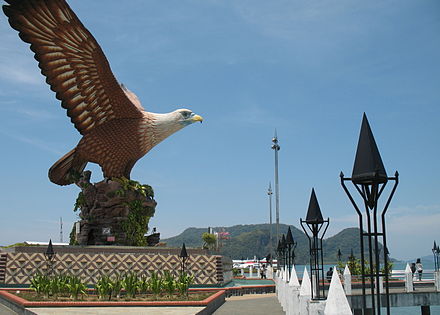
Phone : (604) 966 7789 (Langkawi Tourist Information Centre)
Image credit : wikimedia.org
Dataran Lang” or ‘Eagle Square’, is the location of a large sculpture in the shape of a sea-eagle perched on rocks in pre-flight pose. This 12-meter high statue greets visitors who come to Pekan Kuah by ferry as they ride to the jetty. The eagle is the emblem of Langkawi Island as its name is thought by some to be have been derived from the Malay word for eagle. The Eagle Square is a landscaped area with ponds, terraces and bridges, where visitors may stroll and view the sea.
Source : Wikipedia
Also known as Eagle Square, Dataran Lang is one of Langkawi’s best known manmade attractions, a large sculpture of an eagle poised to take flight. A sight that greets visitors to the island via ferry, the 12 metre-tall statue is one of the island’s most instantly recognizable monuments. Located at the southeast corner of Pulau Langkawi, besides offering beautiful views of Kuah Bay, Dataran Lang has beautiful miniature fountains, terraces and bridges, making it the ideal place for those postcard-perfect holiday photos. The square is a good place to watch ferries ply across the harbour but plan a trip here early in the morning or late in the evening when the sun is at its least intense.
Source : langkawi-info.com
This photo of Oahu is courtesy of TripAdvisor
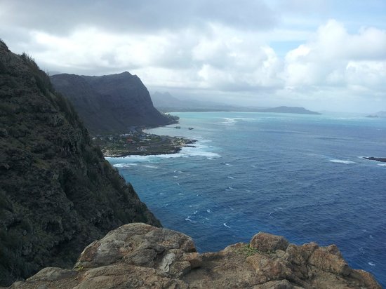
The East Coast Cliffs Oahu are a unbelievable landmark in Oahu Hawaii. Words cannot describe the utter beauty of the landscape of the East Coast of Oahu and awesome power of the ocean that you see at this landmark. The volcanic ash that millions of years ago when Diamond Head and exploded is the clay for the waves that crash against these East Coast Cliffs of Oahu. There are several lookouts and Oahu Hiking Tours along these coastal mountains that make a dramatic view of the entire East Coast of Oahu. Because of the offshore reefs and volcanic tubes, the waves along these cliffs crash against the shoreline ferociously all year long. Swimming is allowed only at approved beaches with lifeguards in Hawaii and hiking is only allowed at approved trails because of the fragile lava rock, which breaks easily, so check out all the Hawaii Hiking Tours that are approved at Hawaii Discount.
The East Fort is located at the heart of Thiruvanathapuram city, the capital city of Kerala – a South Indian state. East Fort got its name from the eastern entrance to the fort built by the Kings of Travancore. The old city was all inside the fort on four sides with the Sri Padmanabha Swami temple at the center. It is said that there were huge metal gates on this entrance to the Fort which was decorated with the symbol of a conch, which was the insignia of the Royal Family of Travancore.
East Fort or Kizhakke Kotta, as it is known in Malayalam, is today the heart of Thiruvananthapuram city. It is the central bus depot for the city bus services run by the state-run KSRTC and KURTC. It is linked by MG Road to rest of downtown Thiruvananthapuram, and is the point of diversion to other parts of the city, as well as the famed Kovalam beach. The city’s Central railway station, as well as the Central Bus Stand (for long distance buses) are both a few minute walk from East Fort, so are most of Thiruvananthapuram’s cinemas, as well as top cultural venues and shopping malls.Sri Padmanabha Swami Temple, from which the city takes its name (Thiru Anantha Puram means ‘the city or puram of Holy (Thiru) Anantha, another name for Vishnu, who is the deity of Sri Padmanabha Swamy Temple), is situated inside the East fort entrance.
Another important landmark is the 125-year-old Attakulangara Government Central High School which was established in the year 1889 by the then social activist Marthandan Thampi during the reign of Ayilyam Tirunal situated near Gandhi park.
Kuthiramalika Palace museum, built by His Highness Swathi Thirunal Rama varma, Maharaja of erstwhile Travancore is also situated inside the Fort complex and its remains.
Gandhi Park is situated in front of the fort, which is famous for hosting socio-politico gatherings. The Ganesha temple, Pazhavangadi Ganapathi Temple, is also situated at the East Fort.
It is from the East Fort that one enters the Chalai Bazaar (Market), which was the main business center of Travancore. Gold, Flowers, Iron and Steel, Fruits and Vegetables to Cars and Computers, this is one spot where you get everything. The beauty of this place and its surroundings is so amazing that it is always swarmed by thousands of tourists daily.
Echo Point is located around 18 km away from Munnar, on the way to the Top Station – the highest point in Munnar. This picturesque spot earns its name because of the natural echo that one can hear resonating in the undulating hills.
Edathua is a place in Kuttanad, , Alappuzha district, Kerala, India. Situated 12 kilometres (7.5 mi) from Thiruvalla Town, Edathua is famous for the St. George Catholic Church known as Edathua Palli, established in 1810 .
The Edathua church celebrates its major feast during the month of May. It is an important destination for the Christian and non-Christian pilgrims. The old Edathua Palli was built when Fr. Thomas Olakkapady was the vicar of the palli. People from throughout the state as well as from the neighboring states visit the town and the church. St. Aloysius college which is under Mahatma Gandhi University built and managed by the Church parish is located here.
The annual feast of the above-mentioned Edathua church starts on 27 April with the hoisting of the flag and concludes on 7 May. During the feast, the statue of St. George, decked in gold regalia, is carried out and placed on the dais at the center of the basilica. St George is known as Geevarghese Punyavalan among Nasrani, St Thomas Christians of Kerela (also known as Syrian Christians because they used a Syrian dialect of Hebrew, instead of the Latin used by some western Christians, in special church prayers). How St George came to be known as Geevarghese and became one of the most popular saints among the Syrian Christians of Kerala is still a topic of interest for researchers to investigate adequately.
Devotees from other states are the main contributors to this Church feast and they spread themselves in vast area around, even staying in the private properties of the local residents. In fact, the feast, known as “Edathua Perunnal”, helped Edathua to develop as one of the most important commercial centers for the rice farmers and agricultural workers in Kuttanad region. During the feast most relatives and family members from outside Edathua come and visit their houses and thus it is an occasion for family get-togethers for the people of Edathua, like Thanksgiving Day and Christmas in the US and Europe. Participating in the feast is a very important pilgrimage for the people especially those from the southern Kollum, Trivandrum side of Kerala and Kanyakumari District of Tamilnad. During the 10-day feast, many of these devotees stay and cook food in the church premises and take part in a kind of ritual bathing in the river in front of the church. The colorful illumination of the church and traditional fireworks during the feast attract huge crowds of devotees and non-devotees.
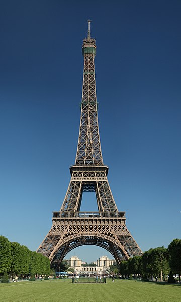
Champ de Mars, 5 Avenue Anatole France, 75007 Paris, France Phone +33 892 70 12 39
Image Credit : wikipedia
The Eiffel Tower is a wrought iron lattice tower on the Champ de Mars in Paris, France. It is named after the engineer Gustave Eiffel, whose company designed and built the tower.
Constructed from 1887–89 as the entrance to the 1889 World’s Fair, it was initially criticized by some of France’s leading artists and intellectuals for its design, but it has become a global cultural icon of France and one of the most recognisable structures in the world. The Eiffel Tower is the most-visited paid monument in the world; 6.91 million people ascended it in 2015.
The tower is 324 metres (1,063 ft) tall, about the same height as an 81-storey building, and the tallest structure in Paris. Its base is square, measuring 125 metres (410 ft) on each side. During its construction, the Eiffel Tower surpassed the Washington Monument to become the tallest man-made structure in the world, a title it held for 41 years until the Chrysler Building in New York City was finished in 1930. Due to the addition of a broadcasting aerial at the top of the tower in 1957, it is now taller than the Chrysler Building by 5.2 metres (17 ft). Excluding transmitters, the Eiffel Tower is the second tallest free-standing structure in France after the Millau Viaduct.
The tower has three levels for visitors, with restaurants on the first and second levels. The top level’s upper platform is 276 m (906 ft) above the ground – the highest observation deck accessible to the public in the European Union. Tickets can be purchased to ascend by stairs or lift to the first and second levels. The climb from ground level to the first level is over 300 steps, as is the climb from the first level to the second. Although there is a staircase to the top level, it is usually accessible only by lift.
Can’t wait to visit the Eiffel Tower? This is one of the things to do in Paris that is on everyone’s list! Here’s some things you should know before visiting the Eiffel Tower Paris…
For those who absolutely have to travel to the top we suggest starting your day at the tower as early as possible; this is a Paris top attraction so the later in the day the longer the lines will be. Trust us, you do not want to spend an entire day at just one attraction, especially if you are on a tight schedule because you only have a few days for your entire vacation in Paris. The other option to save as much time as possible, is to book your trip to the top in advance. Check out our special skip the line package deals offering you money saving tickets that also help you save time to all of the must see attractions in Paris.
GET TO KNOW THE EIFFEL TOWER IN PARIS
The day you visit the Eiffel Tower we recommend that you also plan for a picnic. The park that is located just across the street from the Eiffel Tower is a great place to sit down and enjoy the views. It is also a cost effective way to save money as the only thing to eat in this area is from overpriced venders. For more information on how to visit Paris without spending a fortune, check out our other video, visiting Paris on a budget, to learn about more money saving tips in this beautiful city.
While the Eiffel Tower is the main attraction in the seventh arrondissement of Paris, it is not the only thing to see here. The museum of architecture is a unique find for those who have a passion for the art of architecture. Showcasing the history of the best Beaux Art architecture in Paris, while also offering a glimpse at the future of city construction, this museum is a worthwhile visit. There is also a Maritime museum across the street that is worth a look for the sea lovers as well as a great stop for kids as the museum offers a number of interactive activities, to keep them busy. If you have the Paris Pass, you could enter this museum as well as 50 other attractions, including a river cruise on the Seine! For more details just click on the banner to the right of the screen.
Eklingji is a Hindu temple complex in Udaipur District of Rajasthan in western India. Eklingji is believed to be the ruling deity of Mewar Princely State and the Ruler Maharana rules as his Dewan.
Begun in 971, the temple complex was built by the Guhila dynasty of Mewar, in honor of their presiding deity Eklingji, a form of Lord Shiva. The beautifully sculpted temple complex includes 108 temples within its high walls. The main temple, which dates to the 15th century, was rebuilt from the ruins of an earlier destroyed temple. The walled complex is made of marble and granite and has an enormous double-storied, elaborately pillared hall or “mandap” under a vast pyramidal roof, with a four-faced image of Lord Shiva in black marble. Another temple in the complex is the Lakulish Temple; built in 971, it is the only temple of the Lakulish sect in the whole of India.
Located 22 km north of Udaipur, it is conveniently reached by bus and car. Tourists can access to the complex from RSTC buses that runs from Udaipur to Eklingji and other major destinations of Rajasthan. It takes approximately an hour (60 Minutes) to reach Eklingji from Udaipur. The Eklingji temple is surrounded by long walls of hard rock. This fascinating temple was built in 734 A.D. It consists of 108 temples chiseled out of sandstone and marble. The Maharana of Udaipur pays a private visit to the temple on Monday evening.
Eklingji is a revered place of devotion for Hindu tourists in India. Lord is referred as the kuldevta (or Ishtadevata) of many Brahmins communities including Trivedi Mewada and Bhatt Mewada of Mewar & Gujarat region. Most of the faithful pilgrims visit the temple on Monday to seek the special blessings of Lord Shiva. On other days of the week the temple is relatively crowd free.
There are other ancient temples near Eklingji, such another Shiva Temple that was built in the time of Maharana Raimal between 1473 and 1509.
Elephant Camp Dera Amer situated behind the hills of the famous Amer Fort is the ideal location for outdoor recreational and adventure activities in very close proximity to the city of Jaipur. The Camp is located at the foothills of the Aravali Range and surrounded by the wilderness of a reserved forest with no urban civilization in the vicinity, just a few hamlets housing the local villagers occupied by farming on the their fields bordering a pretty lake.
The elephant treks are conducted in the original Aravali forests surrounding the camp and follow a route passing by hutments, agricultural fields, hills and ancient monuments, the birdlife in the thick forests is thriving and leopards inhabit the jungles as well as hyena and the wolf has been sighted by guests, antelopes and jackals are in abundance. The sunset elephant treks are magical experience-medival temple lit by flame torches, cocktails on elephant back, private fire buckets to keep the guests warm, live barbecue!!
Kottapadi Road J27J+P4P Trishur, Iringaprom, Kerala 680505
Phone : 04872556004
Image credit Wikipedia
Elephant camp at Punnathurkotta is a fort and former palace located in Kottapadi, about 3 km from the Guruvayoor Sree Krishna Temple, in Thrissur District of Kerala State in South India.
Punnathurkotta was once the palace of a local ruler, but the palace grounds are now used to house the elephants belonging to the Guruvayoor temple, and has been renamed Anakkotta (meaning “Elephant Fort”). There were 86 elephants housed there, but currently there are about 59 elephants. The elephants are ritual offerings made by the devotees of Lord Guruvayurappa.
Described as a ‘Palace for Elephants,’ this facility is also used to train the elephants to serve Lord Krishna as well as to participate in many festivals that occur throughout the year. The oldest elephant is around 82 years of age and is called ‘Ramachandran’. The rituals of Gajapooja (Worshipping Elephants) and Anayoottu (Feeding Elephants) are observed here, as an offering to Lord Ganesha. The legendary elephant “Guruvayur Keshavan” was housed here.
Source : https://rb.gy/e4xwpo https://www.youtube.com/watch?v=YARdOpHc28E https://www.youtube.com/watch?v=Koetd6PqF2s Review https://rb.gy/wwwedl Visiting hours : 09.00 AM to 05.00 PM Entry Fee : Rs.20/-
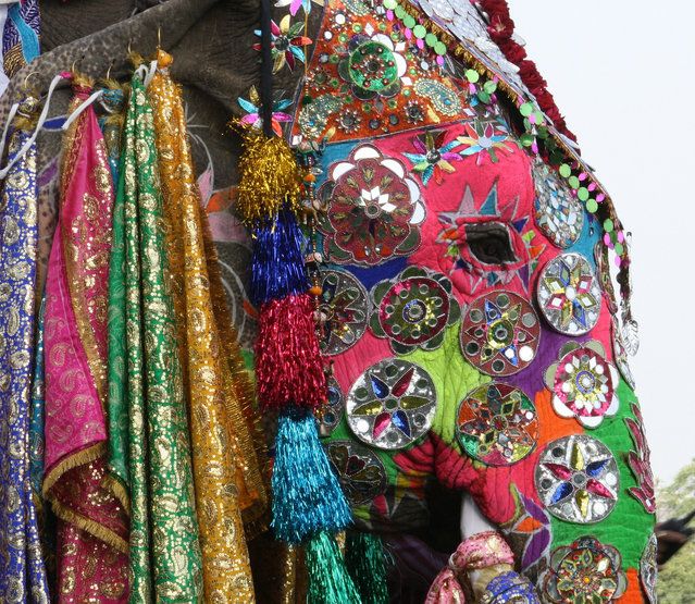
Elephant Festival is a festival celebrated in Jaipur. It is held on the day of Holi festival, usually in the month of March. The festival features Elephant Dance. The Elephant Festival begins with a beautiful procession of bedecked elephants, camels, horses and folk dancers. The owners proudly embellish their elephants with vibrant colors, jhools (saddle cloth) and heavy jewellery. It is quite a treat to see female elephants wearing anklets, which tinkle as they walk. One can see people sprinkling ‘gulaal’ (colored powder) perched on top of the elephant. The most beautifully decorated elephant is awarded. Elephant polo, Elephant race, the tug-of-war between Elephant and 19 men and women are the featured events of the festival. The elephants are also outfitted in ear danglers and brocade scarves to embellish their ears and necks. The Mahouts, who are known as the caretakers of the elephants, decorate the foreheads of the animals with head-plates as well as garnish their tusks with gold, silver bracelets and rings. Other events that take place during the festival include a polo match and a tug of war contest, where the strongest elephant is chosen to compete against a group of ten people.
Although the festival is primarily based on elephants, other animals such as camels and horses also participate in the elephant festival.
Elephant Rehabilitation Centre at Kottur, Kappukad
Elephant Rehabilitation Centre near Kappukadu in India. 695574, Kottoor, Kerala
Image credit : keralatourism.org
From time immemorial elephants have been an integral part of the history, tradition, myth and culture of India and Kerala in particular. One cannot imagine a festival in Kerala without the presence of an elephant.
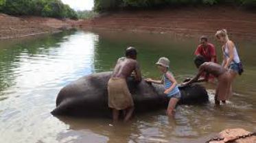
Flanked by the water of the Neyyar reservoir and the moist deciduous forest and grass lands, the Elephant Rehabilitation Centre at Kottur, near Kappukad, located about 35 kms from Thiruvanathapuram, spreads over 56 hectares and is surrounded by trenches to keep wild animals at bay. This provides enough space for all the elephants accommodated here. One of the major highlights of the centre is the chain-free life these mammals enjoy. Freedom to roam, that too in well protected vicinities is something unique to this centre. For the sick and injured elephants the centre is almost like an orphanage or retirement home. 30 elephants can be accommodated within this comfortable zone at a time and they are looked after by a team of experts.
The ideal time to visit the centre is between 9:30 a.m. and 11:30 a.m., when the elephants are bathed and fed. Visitors can lend a hand to the mahouts in these activities. The elephants are fed with cooked rice and jaggery made in to the shape of balls. It is quite amazing to watch mahouts feeding the elephants. Visitors are allowed to go near and enjoy this wonderful spectacle. Elephant ride is another entertainment provided in the centre. For researchers and students this is an ideal place to observe and study the behavior of the giant mammals.
Click On The URL Or PICTURE for the complete News, Videos and more photos.
Emirates is an airline based in Dubai. The airline is wholly owned by the government of Dubai’s Investment Corporation of Dubai. It is the largest airline in the Middle East, operating over 3,600 flights per week from its hub at Dubai International Airport, to more than 154 cities in 81 countries across six continents. Cargo activities are undertaken by Emirates SkyCargo.
It is the world’s fourth largest airline by scheduled revenue passenger-kilometers flown, the fourth-largest in terms of international passengers carried, and the second-largest in terms of freight tonne kilometers flown. It had the longest non-stop commercial flight from Dubai to Auckland until it was surpassed by Qatar Airways.
During the mid-1980s, Gulf Air began to cut back its services to Dubai. As a result, Emirates was conceived in March 1985 with backing from Dubai’s royal family, with Pakistan International Airlines providing two of the airline’s first aircraft on wet-lease. With $10 million in start-up capital it was required to operate independently of government subsidy. Pakistan International Airlines provided training facilities to Emirate’s cabin crew in its academy. The airline was headed by Ahmed bin Saeed Al Maktoum, the airline’s present chairman. In the years following its founding, the airline expanded both its fleet and its destinations. In October 2008, it moved all operations at Dubai International Airport to Terminal 3.
It operates a mixed fleet of Airbus and Boeing wide-body aircraft and is one of the few airlines to operate an all-wide-body aircraft fleet. As of September 2016, Emirates is the largest Airbus A380 operator with 83 planes in service and a further 59 in orders. Since their induction, Airbus A380 planes have become an integral part of Emirates fleet, especially on long-haul heavily trafficked routes. Emirates also has orders for 150 Boeing 777X and 32 Boeing 777-300ER aircraft, and is the world’s largest Boeing 777 operator
Source : wikipedia
Click On The URL Or PICTURE for the complete News, Videos and more photos.
Sir David Frederick Attenborough OM CH CVO CBE FRS FLS FZS FSA is an English broadcaster and naturalist.
He is best known for writing and presenting the nine Life series, in conjunction with the BBC Natural History Unit, which collectively form a comprehensive survey of animal and plant life on the planet. He is also a former senior manager at the BBC, having served as controller of BBC Two and director of programming for BBC Television in the 1960s and 1970s. He is the only person to have won BAFTAs for programmes in each of black and white, colour, HD, and 3D.
Attenborough is widely considered a national treasure in Britain, although he himself does not like the term.In 2002 he was named among the 100 Greatest Britons following a UK-wide vote. He is the younger brother of director, producer and actor Richard Attenborough,[8] and older brother of motor executive John Attenborough.
Sir David Attenborough has several TV projects in development. He continues his long-running collaboration with the BBC Natural History Unit, introducing and narrating the Unit’s first 4K production Life Story, which debuted on BBC One in October 2014. After Life Story, the BBC have indicated that Attenborough is involved in another landmark natural history series “on the scale of Planet Earth and Frozen Planet”.
In October 2014, the corporation announced a trio of new one-off Attenborough documentaries as part of a raft of new natural history programmes. “Attenborough’s Paradise Birds” and “Attenborough’s Big Birds” was shown on BBC Two and “Waking Giants”, which follows the discovery of giant dinosaur bones in South America, aired on BBC One. The BBC have also commissioned Atlantic Productions to make a three-part, Attenborough-fronted series on the Great Barrier Reef. The series marks the 10th project for Attenborough and Atlantic, and sees him returning to a location he first filmed at in 1957.
Attenborough continues his recent partnerships with Sky and UKTV. His next 3D project, Conquest of the Skies, made by the team behind the BAFTA-winning David Attenborough’s Natural History Museum Alive, aired on Sky 3D at Christmas 2014. A third series of David Attenborough’s Natural Curiosities was shown on UKTV channel Watch in 2015. On radio, Attenborough has continued as one of the presenters of BBC Radio 4’s “Tweet of the Day”, which began a second series in September 2014.
On 22 February 2016, the BBC announced Planet Earth II, a sequel to the 2006 television series. Attenborough returned as narrator and presenter, with the main theme music composed by Hans Zimmer.
Click On The URL Or PICTURE for the complete News, Videos and more photos.
HIRO, The Epic Hair Artist
In Osaka, Japan, lies a hair salon called “Trick Store.” One of their artists, Hiro, has created some of the most cutting edge new styles simply by responding to his clients’ requests. He creates hair styles that one can only call works of art along with his clients, cleverly using 3 different sized shavers and paint brushes, which are not typically used in hair styling. He has made styles based on a tomato, lizard, ladybug, goldfish, and more, and when he posted a picture of his tomato style online, the impact was such that it was shared worldwide.
He has been invited to both China and Korea as a lecturer, and says he wants to work internationally in the future as well. It really is difficult to peel your eyes away from his boundary defying work.
Source : exclusivepix.photoshelter.com
A hipster hairdresser has created cutting edge styles for clients by using paint brushes to construct intricate works of art on people’s heads – including a tomato.
Trick Store in Osaka, Japan, creates the “shave art” by trimming patterns into punters’ heads and using dye to create the colourful cuts.
Artist Hiro, who is known as The Epic Hair Artist, has so far made colourful styles based on a tomato, lizard, ladybug, goldfish, pineapple and many more.
He uses three different sized razors to cut locks and the artist says he simply creates the styles by responding to his client’s requests.
Hiro has since been invited to both China and Korea as a lecturer so he can give advice on how to create whacky hairstyles “that have a punch”.
He said: “At Trick Store We do special hair styles and natural ones, whatever you want really.
“We get a lot of different types of people coming here. Some like really flashy styles, while others are into street styles.
Eravikulam National Park is a 97 km2 national park located along the Western Ghats in the Idukki district of Kerala in India.
Eravikulam National Park is administered by the Kerala Department of Forests and Wildlife, Munnar Wildlife Division, which also runs the nearby Mathikettan Shola National Park, Anamudi Shola National Park, Pambadum Shola National Park, Chinnar Wildlife Sanctuary and the Kurinjimala Sanctuary. Eravikulam National Park is a UNESCO World Heritage Site.
Geography
The main body of the park consists of a high rolling hill plateau with a base elevation of about 2,000 m. The terrain consists of high altitude grasslands interspersed with sholas. Anamudi, 2,695 meters, the highest peak in India south of the Himalayas is inside this park. Many perennial streams criss-cross the park. They merge to form tributaries of the Periyar river in the west and of the Cauvery River in the east. Lakkom Water falls is in this region.
Fauna
Twenty six species of mammals have been recorded in the park including the largest surviving population of Nilgiri tahr, estimated at about 750 individuals. The other ungulates are gaur, Indian muntjac and sambar deer. Golden jackal, jungle cat, wild dog, dhole, leopard and tiger are the main predators. Some little-known animals such as Nilgiri langur, stripe-necked mongoose, Indian porcupine, Nilgiri marten, small clawed otter, ruddy mongoose, and dusky palm squirrel are also found. Elephants make seasonal visits.
132 species of birds have been recorded which include endemics like black-and-orange flycatcher, Nilgiri pipit, Nilgiri wood pigeon, white bellied shortwing, Nilgiri flycatcher and Kerala laughingthrush.
Endemic butterflies confined to the shola-grass land ecosystem like the red disk bushbrown and Palni four wing are among the 101 species in the park.
19 species of amphibians have been recorded in the park.
New species of frog found
A new bright reddish-orange-coloured frog with multiple glands and extremely short limbs has been discovered in the Eravikulam National Park. The newly discovered species is restricted to less than three km2 on the peak of Anamudi and deserves immediate conservation priority, scientists S.D. Biju of Delhi University and Franky Bossuyt of the Free University of Brussels said in Current Science. The frog has been assigned the name Raorchestes resplendens. This frog, as compared to all other members of the genus, has multiple prominent glandular swellings: laterally behind the eyes, on the side of the dorsum, on the anterior side of the vent, on the dorsal side of the forearms and shanks, and on the posterior side of tarsus and metatarsus. Additional distinguishing characteristics include the colour of the iris (which is bright red), and extremely short legs.
Flora
Three major types of plant communities are found in the Park – grasslands, shrublands and forests. The terrain above 2000m is covered primarily by grasslands. However, there are numerous small patches of forests in hollows and gullies in these areas. The deeper valleys are extensively forested. Shrublands predominate along the bases of the cliffs and interspersed in rocky slab areas. The antibacterial Eupatorium glandulosum is found here.
The Erechtheion or Erechtheum is an ancient Greek temple on the north side of the Acropolis of Athens in Greece which was dedicated to both Athena and Poseidon.
The temple as seen today was built between 421 and 406 BC. Its architect may have been Mnesicles, and it derived its name from a shrine dedicated to the legendary Greek hero Erichthonius. The sculptor and mason of the structure was Phidias, who was employed by Pericles to build both the Erechtheum and the Parthenon. Some have suggested that it may have been built in honor of the legendary king Erechtheus, who is said to have been buried nearby. Erechtheus was mentioned in Homer’s Iliad as a great king and ruler of Athens during the Archaic Period, and Erechtheus and the hero Erichthonius were often syncretized. It is believed to have been a replacement for the Peisistratid temple of Athena Polias destroyed by the Persians in 480 BC.
Source : wikipedia https://www.youtube.com/watch?v=3ebYvMC12HI https://www.youtube.com/watch?v=ARX6gIKaVmE Reviews https://bit.ly/3vRQYbI Timings : 08:00 am – 07:00 pm Entry : 12 EUR.
Ernakulam Shiva Temple, also known as Ernakulathappan Temple is one of the major temples of Kerala, located in heart of Ernakulam] the downtown area of the city of Kochi. The temple, dedicated to Lord Shiva, is considered as the city temple, with the presiding deity as the protector of the city, as per local Hindu faiths and traditions. As per the common practice in Kerala, the deity is reverently called Ernakulathappan, which means Lord of Ernakulam. The temple is located within the Durbar Hall Ground. The temple history itself has deep association with history of the city and was one of the 7 royal temples of Kochi Maharajas. The temple is now under administration of Cochin Devasom Board. The temple in its current form was built under active patronage of Diwan Sri Edakkunni Sankara Warrier in year 1846 and raised it level of a Royal temple in the Kochi Kingdom. The temple is built on 1-acre (4,000 m2) land. The temple is one of the major Shiva temples in Kerala counted along with the Ettumanoor Mahadevar Temple, Kaduthruthy Mahadeva Temple, Vaikom Temple, Chengannur Mahadeva Temple and Vadakkunathan temple.
Deities
The presiding deity of the temple is Lord Shiva in Gourisankara form, located in main sanctum sanctorum, facing west towards the Arabian sea. The Lingam in the main sanctum sanctorum is considered to be Swayambhoo (Divinely derived). On the northern side of the main sanctum sanctorum, one can see the small shrine of Kirthamoorthy where the original Lingam worshipped by Arjuna is still worshiped. On the southern side, a small shrine for Lord Ganesha is seen. There is a small area behind the main sanctum sanctorum, considered as abode of Goddess Parvati, hence the east gate is known as the Devi Gate. Outside the Inner temple circle, shrines for Lord Ayyappa and Nagaraja are worshiped.
Structure
The entire temple is located in 1.2-acre (4,900 m2) land.The temple is built in typical Kerala temple architecture. The Sanctum complex is circular with fine sculpted walls. The roof is covered with copper tiles. The temple has two gates, the western Gopuram is a two storied structure in typical Kerala architecture with gabled roofs and slanting windows. The eastern gopuram is recently renovated similar to the western side. The Devaswom office is located near the western Gopuram. Recently a new marriage hall and Oottupura (dining hall) is constructed at the northern side.
Festivals
The Uthsavom (temple festival) of Shiva temple is one of the grandest festivals in the Kochi city, normally celebrated during December–January time. The festivities starts with Kodiyettam (hoisting of the temple flag ) on the first day evening. On the seventh day there is Pakalpooram, when the deity is being taken out in procession with caparisoned elephants with Panchavadyam and finally terminating at Durbar Hall Ground after the famous Pandimelam and colourful fire works. On the final day around evening, in a solemn ceremony the flag is lowered and the deity is then taken for the Arattu ( holy bath ) in the nearby temple tank. After that starts the famous Arattu procession with the accompaniment of Panchavadyam. The procession terminates at Durbar Hall Ground. The grand fireworks then bring the curtain down to this week long festival. During all these days Sheeveli is arranged inside the temple and the best available Chendamelam artists are arranged for this. Special poojas connected with the festival are conducted everyday by famous priests from Chennose and Puliyannur Mana. A variety of cultural programmes are also arranged during these days. Special emphasis is given to promote temple arts like Ottamthullal, Paatakam, Thayambaka, Kathakali, Classical dances, Classical music concerts, Bhajans etc. Annadanam is also arranged. Thousands of people throng the temple to witness these programmes. Watching the Pakalpooram and Arattu processions will be an unforgettable experience for anybody. The adjacent Durbar Hall ground becomes a beehive of activities during the Uthsavom.
The temple complex
Adjacent to the main Shiva Temple, two other temples are constructed in the temple grounds, which makes the Ernakulam Temple Complex. On the Northern side, a Murugan Kovil built in Tamil style can be seen. It was constructed by Tamil residents of Kochi during the administration of Diwan Venkataswamy who was a Tamil Brahmin. The Muruga Kovil is managed by Tamil Brahmin Association of Ernakulam and all rituals in this temple are in accordance to Tamil style. The presiding deity is Lord Muruga with his consorts Valli and Devanyani. There are two separate shrines for Navagrahas and Ganesha, apart from regular poojas for Vishnu, Dakshinamoorthy and Durga Devi.
On the eastern side, a Hanuman temple built in Kannadiga Udupi style can be seen. It was constructed by Diwan Venkat Rao in year 1850 as part for his dream to have a temple in traditional Udupi Madhwa Sampradaya style. This is one of the very few temples constructed in Madhwa Sampradaya without Krishna as main deity. The presiding deity is Lord Hanuman facing towards Shiva temple on eastern side. A small idol of Lord Rama also worshiped in main sanctum sanctorum. Apart from this, shrines for lord Nagaraja and Raghavendra Swami are also worshiped.
Apart from the temples, the famous Ernakulam Temple pond is located in eastern side, facing opposite to Murugan temple. There is also offices of Ernakulam Brahmin Association and its marriage hall apart from offices of Temple advisory committee.. A 200-year-old banyan tree can be seen near to Hanuman temple.
Source : wikipedia https://www.youtube.com/watch?v=A2SMY9bMvF8 https://www.youtube.com/watch?v=Tm1bUuMtVa0 Reviews https://goo.gl/EtMahG
Esplanade-Theatres on the Bay, also known as the Esplanade Theatre or simply The Esplanade is a 60,000 square metres (6.0 ha) performing arts centre located in Marina Bay near the mouth of the Singapore river. Named after the nearby Esplanade Park, Esplanade consists of a concert hall which seats about 1,800 and a theatre with a capacity of about 2,000 for the performing arts.
The design consists of two rounded space frames fitted with triangulated glass elements and sunshades, which balance outward views with solar shading. The unique architectural design has been said to have an appearance similar to either a durian (a tropical fruit) or the eyes of a fly. Hence, the building is colloquially known to locals as “the big durians”.
The Esplanade-Theatres on the Bay contains world-class performing spaces, coupled with a wide range of professional support services and facilities. Other than performing venues, it also contains meeting venues, as well as other lifestyle and arts related services. The main highlights of the Esplanade – the concert hall and theatre, are connected to the main concourse via a foyer, while the Esplanade Mall is accessible through an entry point located between these 2 halls.
The library@esplanade, located on the third floor, is Singapore’s first public library devoted to the performing arts. There are also outdoor performing centres, and retail and food space at the Esplanade Mall. There is an outdoor open space on the fourth floor of the building, which is the highest point open to the public.
Esplanade’s in-house programming team presents over 14 festivals and 20 on-going series throughout the year.
Ettumanoor Mahadeva temple is an ancient Shiva temple in Kottayam, Kerala, India. It has brought glory and fame to the place. Myths have it that the Pandavas and the sage Vyasa had worshipped at this temple. The name of the place has its origin from the word ‘manoor’, which means the land of deer. The temple is one of the major Shiva temples in Kerala counted along with the Shiva temples of Chengannur Mahadeva Temple, Kaduthruthy Mahadeva Temple, Vaikom Temple, Ernakulam Shiva Temple and Vadakkunathan temple.
The Temple
The present temple building, with its gopuram and the fortress around it, was reconstructed in 717 ME (1542 AD). There are Dravidian mural paintings on the walls inside and outside of the main entrance. The fresco of Pradosha Nritham (Dance of Shiva) is one of the finest Wall painting in India. There is a golden flag staff inside the temple. On the top of it is the idol of a bull surrounded by small bells and metal leaves of the banyan tree and in terms of architecture this temples stands out to be an ultimate testimant for the vishwakarma Sthapathis, for their engineering skills. The temple roofs are covered with copper sheets and it has 14 ornamental tops. Bhagavati, Sastha, Ganapathy and Yakshi are installed here as subordinate deities. It is believed that the great philosopher, Adi Sankaracharya wrote ‘Soundarya Lahari’ while staying in the temple.
The origin of Ettumanoorappan is from Kattampakk, a small village in Kottayam district.
Festival
Ettumanoor Mahadeva Temple hosts the arattu festival celebrated on a grand scale on the Thiruvathira day in February–March every year. Lot of people come to this temple on the 8th and 10th day of the festival when seven and half elephants (in Malayalam: ezharaponnaana) made of gold (nearly 13 Kgms) will be held in public view. This statue was donated to the temple by a travancore maharaja. The temple, one of the wealthiest Devaswoms in Kerala, has many valuable possessions.
The Thulabharam is one of the important rituals of this temple. People make offerings to God for favours received. On balance, the child or man for whom offerings were promised to God, is weighed against offerings ranging from gold to fruits.
Source : wikipedia https://www.youtube.com/watch?v=zzvzr0io-wM https://www.youtube.com/watch?v=ZvUKsvoiF90 https://www.youtube.com/watch?v=bCOKilRcKRw Reviews https://goo.gl/DhIZPf Timings : 04.00am to 12.00noon and 05.00pm to 08.30pm
Everest Base Camp is either one of two base camps on opposite sides of Mount Everest (It could also be any Everest base camp on a given route, but this is less common since the two main routes became standardized). South Base Camp is in Nepal at an altitude of 5,364 metres (17,598 ft) (28°0′26″N 86°51′34″E), and North Base Camp is in Tibet at 5,150 metres (16,900 ft) (28°8′29″N 86°51′5″E). These camps are rudimentary campsites on Mount Everest that are used by mountain climbers during their ascent and descent. South Base Camp is used when climbing via the southeast ridge, while North Base Camp is used when climbing via the northeast ridge.
Supplies are shipped to the South Base Camp by sherpas or porters, and with the help of animals, usually yaks. The North Base Camp has vehicle access (at least in the summer months). Climbers typically rest at base camp for several days for acclimatization to reduce the risks and severity of altitude sickness.
South Base Camp in Nepal
The Everest Base Camp trek on the south side is one of the most popular trekking routes in the Himalayas and is visited by thousands of trekkers each year. Trekkers usually fly from Kathmandu to Lukla to save time and energy before beginning the trek to this base camp. However, trekking to Lukla is possible. There are no roads from Kathmandu to Lukla and as a result, the only method of transporting large and heavy goods is by plane.
In 2015, it was noted that about 40,000 people per year take the trek from the Lukla airport to the Nepal Everest Base Camp.
From Lukla, climbers trek upward to the Sherpa capital of Namche Bazaar, 3,440 metres (11,290 ft), following the valley of the Dudh Kosi river. It takes about two days to reach the village, which is a central hub of the area. Typically at this point, climbers allow a day of rest for acclimatization. They then trek another two days to Dingboche, 4,260 metres (13,980 ft) before resting for another day for further acclimatization. Another two days takes them to Everest Base Camp via Gorakshep, the flat field below Kala Patthar, 5,545 metres (18,192 ft) and Mt. Pumori.
On 25 April 2015, an earthquake measuring 7.8 on the moment magnitude scale, struck Nepal and triggered an avalanche on Pumori that swept through the South Base Camp. At least 19 people were said to have been killed as a result. Just over two weeks later, on May 12, a second quake struck measuring 7.3 on the Mw. Some of the trails leading to Everest Base Camp were damaged by these earthquakes and needed repairs.
North Base Camp in Tibet
A visit to the North (China-side) Base Camp currently requires a permit from the Chinese government, on top of the permit required to visit Tibet itself. Such permits must be arranged via travel companies in Lhasa as part of a package tour that include hiring a vehicle, driver, and guide. The North Base Camp is accessed by vehicle through a 100 km road branching to the South from the Friendship Highway near Shelkar. From the Base Camp, all tourists must take the buses managed by the government to limit the traffic in the last stretch of gravel road to a marked hill at 5,200 meters above sea level just before the climbers’ camp. It is also possible to trek up from the tourist camp, but only when properly acclimatized. The “tourist Base Camp” is located about halfway between Rongbuk Monastery; the actual climbers’ Base Camp is at the foot of Rongbuk glacier.
Source : wikipedia https://www.youtube.com/watch?v=elq7tkE46WQ https://www.youtube.com/watch?v=_BgW7gdHGBI
Located at a distance of 18 kms. from Shimla and 6 kms. from Kufri.
Image Credit : tripadvisor.in
Fagu is a tiny village aside a saddle-like mountain along Hindustan Tibet Road. A rare range of views is visible from here, which include vivid dales and snow clad peaks. The picturesque countryside is dotted with clusters of villages, fruit gardens and nearby terraced fields. Fog characterizes the hillside landscape endowed with romantic ambience. Most of the area is covered with conifers of Himalayan cedar and spruce. Located at an altitude of 2,450 m, the place, perhaps have derived its name from the fog itself.
Jalan Prima Tropika Barat 2, Taman Prima Tropika, 43300 Seri Kembangan, Selangor, Malaysia
Phone : +60 3-8941 2099
Farm in the City is the place for visitors who want to enjoy a non-traditional zoo experience. It is a new Malaysian village themed petting zoo in Taman Equine, Seri Kembangan, between Kaula lumpur and Putrajaya. The place is divided into several sections including a reptile corner, koi pond and bird aviary. There is a turtle and tortoise section which is home to about five different types of these hard-shell reptiles. Some of the rare animals you can see here include a crusty-looking dinosaur turtle and a crow with snow white plumage. One of the great things about this park is that you can really interact with the animals. You can even feed a deer from the palm of you hand. Farm in the City is beautifully landscaped and there is even a section where kids can go inside the rabbit and guinea pigs enclosure and play with them. More than 100 species of exotic and rare species are on display behind glass walls or in open compounds.
Opening hours : 09.30AM to 06.00PM. Closed on Tuesdays (unless it’s a public or school holidays)
Admission fee : RM48 for adult and RM38 for children below 12
Getting there : It is 15 minutes drive from Putrajaya. KLIA Transit is the operator of trains to and from Putrajaya Sentral. Putrajaya station is situated in the Kualalumpur International Airport train line. Though KLIA Express and KLIA Transit trains are passing through the Putrajaya station, The KLIA Transit is the only train stops at Putrajaya station. (KLIA Express is a non-stopping service from KL Sentral to KLIA airport) The fastest way of reaching Putrajaya from KL Sentral is through KLIA Transit train.
Fateh Sagar Lake is situated in the city of Udaipur. It is an artificial lake named after maharana Fateh Singhof Udaipur and Mewar ,constructed to the north-west of Udaipur, located to the north of Lake Pichola in the 1680s.
It is one of the four lakes of the Udaipur city; the other three being : the Lake Pichola (within the Udaipur town), Udai Sagar Lake (13 km to the east of Udaipur) and Dhebar Lake or Jaisamand Lake (52 km south east of Udaipur).
Within the confines of the Fatah Sagar Lake, there are three small islands; the largest of these is the Nehru Park (4 km2 area), which is a popular tourist attraction, the second island (0.06 km2 area) houses a public park with an impressive water-jet fountain and the third island (1.2 km2 area) is the address for the Udaipur Solar Observatory (USO). The Nehru park is accessible by inboard motor boats. The blue waters of the lake and the backdrop of the green mountains has given the soubriquet of ‘the second Kashmir’ to Udaipur .
Udaipur Lake Conservation Society’s reports indicate that the lake supports and sustains ground water recharge, drinking water, agricultural use, industrial use, ecological water availability and provides employment to 60% population of Udaipur.
Visiting hours : 08.00AM to 04.30PM, all days of the week
Entry fee : Free
Nehru Park
Image Credit : holidayiq.com
Take a romantic boat ride in the Fateh Sagar Lake and reach the oval shaped Nehru Garden. Nehru Garden is named after the first Prime Minister of India, Jawaharlal Nehru. Inaugurated on his birth anniversary on 14th November, 1967, it is an oval shaped island. Located in the centre of Fateh Sagar, it overlooks the ancient Moti Mahal of Maharana Pratap. Within its area of 4.5 acres, the park contains flower gardens and a lily pond.
Pyramid shaped, the fountains are of channel type. In the north-west of the park lies a boat-shaped floating restaurant. By boats, tourists can reach this park from one side of the lake.
Old Water Tank Road,
Coober Pedy,
South Australia 5723 Australia
Phone : +61 490 810 433
Image credit : Tripadvisor
Faye’s Underground Home underground home (or dugout as the locals call them) was excavated in the original method using picks and shovels and a lot of blood, sweats and tears. Built forty years ago by three women this attraction is an insight in to the strength of character that Coober Pedy was built on.
The current couple residing here has opened it to the public. This has a small indoor pool, fully-furnished kitchen, fireplace (for winter heating), and comfortably furnished rooms. https://www.youtube.com/watch?v=uFA-OB-nJ_I https://www.youtube.com/watch?v=-1XSKu3pK8A Reviews : https://bit.ly/33XQap1 Open: Monday – Saturday 8.30am to 5pm Entry fee : adult $10 and child $/2
The September 11 attacks (also referred to as 9/11) were a series of four coordinated terrorist attacks by the Islamic terrorist group al-Qaeda on the United States on the morning of Tuesday, September 11, 2001. The September 11 attacks killed 2,996 people, injured over 6,000 others, and caused at least $10 billion in property and infrastructure damage and $3 trillion in total costs.
Four passenger airliners operated by two major U.S. passenger air carriers (United Airlines and American Airlines)—all of which departed from airports in the northeastern United States bound for California—were hijacked by 19 al-Qaeda terrorists. Two of the planes, American Airlines Flight 11 and United Airlines Flight 175, were crashed into the North and South towers, respectively, of the World Trade Center complex in New York City. Within an hour and 42 minutes, both 110-story towers collapsed, with debris and the resulting fires causing partial or complete collapse of all other buildings in the World Trade Center complex, including the 47-story 7 World Trade Center tower, as well as significant damage to ten other large surrounding structures. A third plane, American Airlines Flight 77, was crashed into the Pentagon (the headquarters of the United States Department of Defense) in Arlington County, Virginia, leading to a partial collapse of the building’s western side. The fourth plane, United Airlines Flight 93, initially was steered toward Washington, D.C., but crashed into a field in Stonycreek Township near Shanksville, Pennsylvania, after its passengers tried to overcome the hijackers. It was the deadliest incident for firefighters and law enforcement officers[5] in the history of the United States, with 343 and 72 killed respectively………………………………………………..
Source : wikipedia
Fira, sometimes spelt ‘Thira,’ is the modern capital of the Greek Aegean island of Santorini. A traditional settlement, “Firá” derives its name from an alternative pronunciation of “Thíra”, the ancient name of the island itself.
Fira is a city of white-washed houses built on the edge of the 400 metres (1,312 feet) high caldera on the western edge of the semi-circular island of Thera. The two main museums of interest are the Archaeological Museum of Thera, 30 metres (98 feet) east of the cable car entrance, and the Museum of Prehistoric Thera at the southeast corner of the White Orthodox Cathedral of Ypapanti, built on the site of an earlier church destroyed in the 1956 Amorgos earthquake. The town also hosts a number of churches, including the Cathedral of Ypapanti and the Three Bells of Fira.
Access to Fira is mainly by roads on its eastern side, climbing from its port via the Z-shaped footpath on foot or on donkeys, or by riding the steep cable car from its lower terminal by the port. The central square of Fira is called Plateia Theotokopoulou, with a bus and taxi station, banks, and pharmacies.
From Fira there is a panoramic view of the 18 kilometres (11 miles) long caldera from southern Cape Akrotiri to northern Cape Ag. Nikolaos, plus the volcanic island Nea Kameni at the center with Thirassia Island. Large cruise ships anchor in the small harbor between Nea Kameni and Fira.
Source : Wikipedia https://www.youtube.com/watch?v=OyO8nnKYza4 https://www.youtube.com/watch?v=ux9Y0AN-_K0
Firiplaka or Firiplaka Beach is a beach situated at the southern side in Milos Island, Greece between the other beaches of Provatas (West) and Tsigrado (East). It is one of the most popular beach on the island. The beach is extensive with majestic towering volcanic cliffs, snow-grey fine sand and white pebbles and shallow turquoise waters. There are umbrellas and sunbeds and a bar hut. There is also a huge rock with a cave under it in the water near the shore and it was sculptured out from a volcanic a long time ago. The access to the beach is possible by your own vehicle, taxi, bus or even boat which goes around the island from the port of Adamas. The largest part of the road is asphalt, however the last part of it, is a gravel paved driveway.
Source : Wikipedia https://www.youtube.com/watch?v=mHERwQIYKb4 https://www.youtube.com/watch?v=9Xpcj7nBnb4 https://www.youtube.com/watch?v=6aoMzRSq-uk Reviews https://bit.ly/2ZVuRnc
Click On The URL Or PICTURE for the complete News, Videos and more photos.
IMG Worlds of Adventure is an indoor amusement park in the United Arab Emirates in Dubai. It is Dubai’s first mega themed entertainment destination. The park is divided into four “epic zones”. Two of the four zones represent global brands Cartoon Network and Marvel, while IMG Boulevard and the Lost Valley – Dinosaur Adventure zones are original concepts created by the IMG Group.
IMG Worlds of Adventure is the largest temperature controlled indoor themed entertainment destination in the world, covering an area in excess of 1.5 million square feet. With the capacity to welcome more than 20,000 guests a day, the destination is featuring a unique array of adrenaline-pumping roller coasters, thrill rides, and spine-tingling attractions based on popular Cartoon Network characters, iconic Marvel Super Heroes and hair-raising dinosaurs. Additionally, the destination is the home to a number of world-firsts, a variety of themed retail stores, exclusive dining venues, and a 12-screen state-of-the-art cinema.
Situated within City of Arabia, along Sheikh Mohammad Bin Zayed Road, IMG Worlds of Adventure is set to be a must-visit international destination, bringing the best of family entertainment to Dubai’s growing leisure industry.
The theme park was built by the Ilyas and Mustafa Galadari (IMG) Group and is the world’s largest indoor theme park. The park was part of the City of Arabia development project, a part of Dubailand, which was stalled due to the 2008 property crash. In April 2014, the park got a Dh1.2 billion ($326 million) loan from the Abu Dhabi Islamic Bank. The park itself is valued over $1 Billion. Developers predict that the park will welcome 10,000 visitors daily, and has the capacity to hold up to 20,000 daily.
The complex was originally set to open in early 2014, has been since been delayed to late 2014, and again to August 31, 2016 The IMG Group stated in January 2014 that the foundations for the rides were nearly complete and that the structure of the building is complete.
The theme park includes 17 themed rides.
The park contains four themed areas, called “Epic Zones”. The park also contains a 12-screen cinema. Falcon’s Creative Group was the primary design firm involved in designing process.
Cartoon Network is one of the zones and based on cartoon characters from Cartoon Network. It contains the world’s first 5D Ben 10 cinema and the largest Ben 10 store in the world.
Source : wikipedia
Click On The URL Or PICTURE for the complete News, Videos and more photos.
Jesus Tomb is located inside the Church of Holy Sepulchre.
The Church of the Holy Sepulchre[b] (Greek: Ναός της Αναστάσεως, Naos tes Anastaseos; Armenian: Սուրբ Հարության տաճար Surb Harut’yan tač̣ar; Latin: Ecclesia Sancti Sepulchri;[c] also called the Church of the Resurrection or Church of the Anastasis by Orthodox Christians) is a church in the Christian Quarter of the Old City of Jerusalem, a few steps away from the Muristan. The church contains, according to traditions dating back at least to the fourth century, the two holiest sites in Christianity: the site where Jesus of Nazareth was circumcised, presented in the temple, where he drove out the money changers, was crucified, at a place known as “Calvary” or “Golgotha”, and Jesus’s empty tomb, where he is said to have been buried and resurrected. The tomb is enclosed by the 18th-century shrine, called the Edicule (Aedicule)…………………………………………….
Source : wikipedia
Fiskardo is a village and a community on the Ionian island of Kefalonia, Greece. It is part of the municipal unit of Erisos. It is the northernmost port of Kefalonia, a short distance from Ithaca. It has a small and diminishing fishing fleet. The coast around Fiskardo is mainly rocky with numerous pebble-beached coves. The port serves ferry routes to the ports of Frikes (Ithaca) and Lefkada. It is 5 km north of Vasilikades, 24 km north of Sami and 32 km north of Argostoli. Cephalonia International Airport is 61 km to the south, by road (about 1½ hours). The community here consists of the villages Fiskardo, Evreti, Katsarata, Matsoukata and Tselentata.
It is also the name of the two kilometre long bay in which the port is located. Fiskardo and the dense forest in the surrounding area have been declared areas of great natural beauty and are protected under Greek law. In recent years a small tourist industry has developed, centred on luxury villas in the area around the village.
Source : Wikipedia https://www.youtube.com/watch?v=AsvCn5szLUw https://www.youtube.com/watch?v=zfUMQRlQXag Reviews https://bit.ly/31kdT2Q
The historic harbour village of Fiskardo, one of the most beautiful part of Kefalonia, is undeniably one of the highlights of any trip to Greek island
Tanjung Bungah Road, Pulau Pinang, 11200, Penang, Malaysia
Phone : +60 4-250 2800
Sourse : tripadvisor.co.uk
The Penang Floating Mosque or Masjid Terapung Pulau Pinang or also known as Tanjung Bungah Floating Mosque or Masjid Terapung Tanjung Bungah is a floating mosque located in Tanjung Bungah near George town, Penang, Malysia. Despite its name, the mosque is not actually floating, but rather standing on pilings and stilts. Nevertheless it is the first mosque to be built in the sea in Malaysia (other floating mosques in Malaysia have so far been built in lakes). It was built to replace the old Tanjung Bungah Mosque.
Visiting hours : permission to enter must be obtained from the mosque officials. No shoes are allowed inside the mosque, and all visitors must be decently dressed. Closed during Friday prayers (from 12:00 – 14:30).
Getting there : The Masjid Terapung Tanjung Bungah is easily accessible from the Tanjung Bungah main road. It is located on the opposite side of the road from the Mar Vista Condominiums. Rapid Penang buses 101, 103 and 104 goes to Tanjung Bungah (Bus 104 may require some walking, as it goes to Tanjung Bungah village).
The Florence Cathedral, officially known as the Cattedrale di Santa Maria del Fiore (Cathedral of Saint Mary of the Flower), is one of the most iconic and magnificent landmarks in Florence, Italy. Here are some key details about the Florence Cathedral:
History: Construction of the Florence Cathedral began in 1296 and took several centuries to complete. The cathedral is an example of Italian Gothic architecture and was designed by architect Arnolfo di Cambio.
Architecture: The Florence Cathedral is known for its stunning facade, elaborate marble detailing, and the famous dome designed by Filippo Brunelleschi. The dome is a masterpiece of Renaissance engineering and architecture.
Brunelleschi’s Dome: The dome of the cathedral is a remarkable achievement and a symbol of Renaissance innovation. It is a self-supporting structure without the need for a central column or external buttresses. Visitors can climb to the top of the dome for panoramic views of Florence.
Interior: The interior of the cathedral is vast and features beautiful stained glass windows, intricate frescoes, and a magnificent marble floor. The cathedral is richly decorated with artworks and sculptures.
Giotto’s Campanile: Adjacent to the cathedral is Giotto’s Campanile, a free-standing bell tower that is also a masterpiece of Gothic architecture. Visitors can climb the campanile for panoramic views of the city.
Baptistery: The Florence Baptistery (Battistero di San Giovanni) is another significant structure adjacent to the cathedral. It is known for its beautiful bronze doors, including the famous Gates of Paradise by Lorenzo Ghiberti.
Religious Significance: The Florence Cathedral is the main church of the Archdiocese of Florence and is dedicated to the Virgin Mary. It plays an important role in the religious life of the city.
Tourism: The Florence Cathedral is a major tourist attraction and a UNESCO World Heritage Site. Visitors from around the world come to admire its architectural beauty and historical significance.
Climbing the Dome: Visitors can climb the dome, but it’s advisable to make a reservation for this experience, especially during peak tourist seasons.
The Florence Cathedral is not only a religious center but also a symbol of the city’s cultural and artistic heritage. It is a must-visit for anyone exploring Florence and offers a profound experience of Italy’s architectural and artistic achievements.
Source : openai.com Visiting hours : The Cathedral is open Monday to Saturday from 10:15 AM to 4:45 PM and closed on Sundays. The Dome is open Monday to Friday from 8:15 AM to 7:30 PM, Saturday from 8:15 AM to 5:15 PM, and Sunday from 12:24 PM to 5:15 PM. Entrance : https://shorturl.at/ftyI8 Entrance to cathedral is free. https://www.youtube.com/watch?v=QD3fJphus-o https://www.youtube.com/watch?v=kggMd8oObC0
The Florence Cathedral, officially known as the Cattedrale di Santa Maria del Fiore, is one of the most iconic and magnificent landmarks in Florence
Fort Canning is a small hill slightly more than 60 metres high in the southeast portion of the island city-state of Singapore, within the Central Area that forms Singapore’s central business district. Although small in physical size, it has a long history intertwined with that of the city-state due to its location as the highest elevation within walking distance to the city’s civic district within the Downtown Core. It is also a popular venue for music shows and concerts.
Now a park overlooking Orchard Road and set in the heart of the Civic and Cultural District of Singapore, Fort Canning offers a variety of recreational activities, historical, educational, entertainment and cultural experiences. The park also serves as an important green lung for Singapore’s downtown city area. The unique blend of historical relics, lush greenery and expansive lawns has made Fort Canning a hub of cultural and artistic activity. It has been a venue of choice for staging myriad outdoor events and activities like theatre carnivals, art festivals, starlight cinemas and Ballet Under the Stars performances. WOMAD, Singapore’s largest music festival, has been a regular feature of the park’s calendar of events since 1998. The Fort Canning Tunnel passes directly under the hill.
Highlights
Spice Garden: The garden is a replica of the first experimental botanical garden in Singapore established by Sir Stamford Raffles. Raffles had noble ambitions for Singapore’s agricultural development, and had sent from Bencoolen spices like clove plants and nutmeg seeds to be planted in the garden. Gothic Gates: These imposing and sombre gateways in gothic style lead the visitor into Fort Canning Green, where a Christian cemetery used to stand. Built in 1846, these gates have since become a landmark of Fort Canning Hill. The letters above both gates, “IHS” are iota, eta and sigma, the first three letters of the Greek word for Jesus. Fort Canning Green: The frequent outdoor concerts and carnivals now held at Fort Canning Green belie the fact that the area was once a graveyard for some 600 Christian graves. The only graves left are at the far end of the Green (near the Drama Centre). Some tombstones that were removed were set into the walls surrounding Fort Canning Green. Cupolas: The cupolas, designed by George Drumgoole Coleman, were probably places of rest. The word ‘cupola’ means a small dome-shaped roof or ceiling. George Coleman was a talented architect who left his mark on the urban landscape of Singapore. He was Raffles’ consultant on Singapore’s first town plan. As Superintendent of Public Works, he oversaw projects of land reclamation and construction of roads and landmarks such as the Armenian Church. James Brooke Napier Memorial: Dedicated to James Brooke Napier, the infant son of William Napier, who was Singapore’s first Law Agent, and Maria Frances Napier, the widow of George Coleman. The memorial was the largest erected in the cemetery, reflecting the status of William Napier. Fort Canning Arts Centre: Fort Canning Arts Centre used to be the barracks of the British Army. The British Army chose Fort Canning as its headquarters of its defence bases in the 1920s to protect British interests in Southeast Asia. Underground Far East Command Centre (The Battle Box): During the Second World War, Lieutenant General Arthur Ernest Percival (Commander of British Forces) used the underground bunkers at Fort Canning as his commanding base. Sally Port: The sally port is a small hidden door that leads into or out of a fort, allowing occupants to escape from the fort undetected. Fort Canning had at least three sally ports but only one remains today. Fort Wall and Gate: Raffles, in a letter to William Farquhar in 1819, on the suitability of building a fortress on Government Hill: ” …On the hill overlooking the Settlement, and commanding it and a considerable portion of the anchorage, a small Fort, capable of mounting 8 or 10 pounders and of containing a magazine of brick or stone, together with a barrack for the permanent residence of 30 European artillery, and of temporary accommodation of the rest of the garrison in case of emergency.” 9-Pound Cannon: One of a pair of cannons that was meant to shoot 9-pound balls. Playing a decorative role rather than a defensive one, the cannon was fired three times a day at 5 a.m., 1 p.m., and 9 p.m. to announce the hour. It was also fired as a salute and warning of town fires. Next to the cannon is South Battery, the site at which the main battery of guns was mounted to defend Singapore in the 19th century. Raffles’ House: Raffles built his house on Government Hill on his third and last visit to Singapore. “We have lately built a small bungalow on Singapore Hill where, though the height is inconsiderable, we find a great difference in climate. Nothing can be more interesting and beautiful than the view from this spot. The tombs of the Malay Kings are close at hand, and I have settled that if it is my fate to die here I shall take my place amongst them: this will at any rate be better than leaving my bones at Bencoolen…” – Raffles in a letter to William Marsden in 1823. Keramat Iskandar Shah: Keramat Iskandar Shah is a sacred place dedicated to Iskandar Shah (also known as Parameswara before he converted to Islam), the last ruler of 14th century Singapore before he fled to Melaka to escape an attack from the Siamese. Although named after him, scholars thought that the keramat could not be Iskandar Shah’s tomb as he had died in Melaka. Archaeological Excavation Site: In 1984, archaeologist John Miksic and his team began an archaeological excavation that continues until today. Among the artefacts recovered were porcelain, earthenware and glass shards. These artefacts show that there could have been a Malay kingdom on Fort Canning Hill, with possibility of glass and gold workshops.
Jalan Tun Syed Sheh Barakbah, 10200 George Town, Pulau Pinang, Malaysia
Phone : +60 4-262 0202
Image Credit : visitpenang.gov.my
The Fort Cornwallis is a star fort that the British East India company built in the late 18th century on the northeastern coast of Penang island, Malaysia. It is named after the late 18th century Governor-General of Bengal, India, Charles Cornwallis, 1st Marduess Cornwallis. Fort Cornwallis is the largest standing fort in Malaysia. In its entire history, the fort has never engaged in any battle.
Source : Wikipedia
At fort Cornwallis the five major must-see artefacts are, first and foremost, the bronze statue of the legendary Sir Captain Francis Light who, from the British East India Company, first landed on the island with his crew in the year 1786. In fact, no visitors would be able to miss the statue of Francis Light as its positioned overlooking the fort entrance, greeting visitors.
The second must-see artefact would be the infamous Sri Rambai cannon, which has a history and folklore of its own standing. The cannon were originally a gift from the Dutch to the Sultan of Johor in 1606. it is believed that infertile women would be able to conceive if they were to place flowers on the barrel of the Sri Rambai cannon, as the cannon is believed to possess superior powers that can grant the wishes of the women asking.
Next would be the gun powder magazine in which explosives were once stored during the British administration in anticipation for a battle. The structure of the bunker was built in the shape of a pill box with a thick wall to minimise damage should there be any explosions that may happen.
The ever first Christian chapel, as well as one of the earliest roofed structures in the history of Penang, can be found inside the fort.
Last but not least, beside the chapel, will be the row of barracks and a small jail cell that are still in its origin state which was built in 1811. The jail, now a favorite photographing spot whereby visitors would get the feel of being in prison behind bars and be photographed from the outside, complete with the prisoner cell’s number.
Two photo boards with colonial images are erected at the open field of the fort. These photo boards are spot for visitors to capture pictures of themselves with the colonial image as the backdrop.
To explore the historic town of Fort Kochi, there is no better choice than setting out on foot. Relax, breathe deeply and come out in cotton, soft shoes and yes – a straw hat. At every nook of this island steeped in history, there is something magical awaiting you. It is a world of its own, retaining the specimens of a bygone era and still being proud of those days. If you can smell the past, nothing can stop you from walking through these streets.
Walking straight through the K. J. Herschel Road and turning left, you can have a glimpse of Fort Immanuel. This bastion once belonged to the Portuguese and is a symbol of the strategic alliance which existed between the Maharaja of Cochin and the Monarch of Portugal, after whom the fort is named. This fort was built in 1503 and reinforced in 1538. Walking a bit further, you come across the Dutch cemetery. Consecrated in 1724 and managed by the Church of South India, the tombstones here silently remind visitors of those Europeans who left their homeland to expand their colonial empires.
The next spot to watch out for is the ancient Thakur House, which stands erect as a concrete specimen of the colonial era. The building is simply graceful. Formerly known as the Kunal or Hill Bungalow, it was home to the managers of the National Bank of India during the British rule. Now, it belongs to the Thakur and Company, a renowned tea trading firm.
Walk on and there is another colonial structure awaiting you – David Hall. It was built around 1695 by the Dutch East India Company. The hall is associated with Hendrik Adriaan van Reed tot Drakeston, renowned Dutch commander, who is more admired for his monumental book on the flora of Kerala namely Hortus Malabaricus. However, David Hall is named after David Koder, a later occupant of the hall.
Walking past the Parade Ground, the four acres of ground where the Portuguese, the Dutch and the British once conducted military parades, you reach the St. Francis Church, the oldest European church in India. It has passed through many phases ever since the Portuguese built it in 1503. Now the church is under the Church of South India. By the way, it was in this church that Vasco-da-Gama had been buried first and his tombstone can still be seen. His remains were returned to Portugal in 1539.
The Church Road is a nice place to walk, with the cool breeze from the Arabian Sea caressing your body. Walk down a bit closer to the sea and there is the Cochin Club, home to an impressive library and collection of sporting trophies. Set in a beautifully landscaped park, the club still retains its British ambiance.
Walking back to the Church Road, on the left side, you stumble across another majestic mansion, the Bastion Bungalow. This wonderful structure of Indo-European style had been built in 1667 and is named after its location on the site of the Stromberg Bastion of the old Dutch fort. Now it is the official residence of the Sub Collector.
The Vasco-da Gama Square is nearby. A narrow promenade, this is an ideal place to relax a little. Stalls full of delicious seafood and tender coconuts are simply tempting. Savour a bit and feast your eyes on the Chinese fishing nets, being raised and lowered. These nets had been erected here between AD 1350 and 1450 by the traders from the court of Kublai Khan.
Refreshed, you can now proceed to the Pierce Leslie Bungalow, a charming mansion, which once served as the office of Pierce Leslie and Co., coffee merchants of yesteryear. This building reflects Portuguese, Dutch and local influences. Its waterfront verandahs are an added attraction. Turning right, you come to the Old Harbour House, built in 1808 and owned by Carriet Moran and Co, renowned tea brokers. Nearby is the Koder House, the magnificent building constructed by Samuel S. Koder of the Cochin Electric Company in 1808. This structure shows the transition from colonial to Indo-European architecture.
Turn further right and you reach the Princess Street. Mind having some fresh flowers from the shops here. One of the earliest streets of the area, this road has European style residences on both its sides. Located here is the Loafer’s Corner, the traditional hangout for the jovial and fun loving people of Kochi.
Walking northwards from the Loafer’s Corner, you come across Santa Cruz Basilica, the historic church built by the Portuguese and elevated to a Cathedral by Pope Paul IV in 1558. In 1984, Pope John Paul II declared it as a Basilica. After having a quick look at the Burgher Street and the Delta Study, a heritage bungalow built in the year 1808 and now functioning as a high school, you walk down, once again to the Princess Street and then to the Rose Street. There you find Vasco House, believed to be the residence of Vasco-da-Gama. This traditional and typical European house is one of the oldest Portuguese residences in Kochi.
Turning left, you walk over to the Ridsdale Road to find the VOC Gate, the large wooden gate facing the Parade Ground. The gate, built in 1740, gets its name from the monogram (VOC) of the Dutch East India Company on it. Close by is the United Club, once one of the four elite clubs of the British in Kochi. Now, it serves as a classroom for the nearby St. Francis Primary School.
Walking straight, you reach the end of the road and there is the Bishop’s house, built in the year 1506. It had once been the residence of the Portuguese Governor and is set on a small hillock near the Parade Ground. The facade of the house has large Gothic arches and the building was acquired by Dom Jos Gomes Ferreira, the 27th Bishop of the Diocese of Cochin whose jurisdiction extended over Burma, Malaya, and Ceylon apart from India.
Yes, now it is time to wind up the walk. With the feel of the bygone days still lingering in your mind, mesmerising sights staying back in your eyes and your taste buds yearning again for the delicacies, it will be no surprise if your heart yearns for another walk.
Source : keralatourism.org
The Fort Kochi beach, with its clean premises and tranquil atmosphere, is frequented by tourists as well as the local people.
There are many factors that differentiate the beach from the other beaches of Kerala. The presence of the Chinese fishing nets is probably the most easily identifiable one. The trees and the greenery on the walkway to the beach add to the serene atmosphere there. It is on these beaches that the famous Cochin Carvinal is conducted on New Year’s Eve.
The sea food, the Vasco da Gama Square adjacent to the beach, a light house and a granite walkway are the other main attractions. The beach also gives you a breathtaking view of the sunset. If you are lucky, you may glimpse cargo ships passing through the sea. The remains of the Fort Immanuel can also be seen here. A section of the beach is not accessible to visitors as it is under the control of the Indian Navy.
Source : keralatourism.org https://www.youtube.com/watch?v=ySPTXKY9TE4 https://www.youtube.com/watch?v=uPBmTcmzWkI Reviews https://goo.gl/5mN4qu
12-pounder gun at Fort Siloso facing the oil refinery at Singapore harbour.
Singapore’s only preserved coastal fort stands as witness to one of the most tempestuous chapters in local history.
In the 19th century, Singapore became an important sea trading port for the British. To defend the island from sea invasion, Fort Siloso was once one of the three forts that were built on Sentosa Island (once known as Pulau Belakang Mati.
During World War II, the Japanese troops invaded Singapore from the north through peninsula Malaya and the guns in Fort Siloso were turned landwards to support the ground troops.
Today, being the only preserved coastal fort in Singapore, Fort Siloso is a historical attraction with a rich memorabilia of pre-WWII and WWII-era guns and remains of fortified military structures and tunnels.
Admission into Fort Siloso is FREE.
Surrender Chambers
The gallery features the British and Japanese surrender waxworks which marked two significant surrender ceremonies in Singapore during WWII. The Surrender Chambers feature commentaries and exhibitions which bring you through the history of Singapore, from the British Surrender to the independence of the nation.
Go back in time and experience these surrenders with the guided commentary available every 30 minutes.
Guided Tour
Learn why the Fort was built, discover life as a soldier, explore preserved underground ammunition stores and WWII-era guns. Experience the Fort with the guides in the 90-minute walking tour.
The Tour will retrace the historically preserved remains at the fort to discover the purpose of the various fortified structures and the guns they serve, ending with a visit to the Surrender Chambers to witness the two historic surrender moments that changed the life of the people of Singapore during WWII.
Surrender Chambers
Standard Rates
S$6 / Adult
S$4.50 / Child (Age 3-12 years old)
Local Resident Rates*
S$5 / Adult
S$3.50 / Child (Age 3-12 years old)
Guided Tours
Standard Rates
S$20 / Adult
S$14 / Child (Age 7-12 years old)
Local Resident Rates*
S$15 / Adult
S$10 / Child (Age 7-12 years old)
Tour Timings: 11.30am to 1pm, 1.30pm to 3pm, 2pm to 3.30pm, 4pm to 5.30pm. Maximum group size of 20 guests for each tour.
*Singapore citizens, permanent residents and those living in Singapore, including holders of employment passes, work permits or dependent passes. Admission Restriction
NA
Getting There
By Sentosa Express: Alight at Beach Station. Transfer to the Sentosa Bus 1
By Bus: Board Sentosa Bus 1 and alight at Siloso Point stop
By Sentosa Beach Tram: Alight at Siloso Point Stop
By Foot: Take a stroll down the beach from Beach Station
The 11-storey, 181 meters long Fort Siloso Skywalk trail provides guests a scenic trek among the treetops en route to Fort Siloso. Both the Skywalk and Fort Siloso are free for all. There are even weather canopies installed at intervals in case of sudden downpours; a nice touch. Nice views and there are interesting display panels explaining what you are looking for. This is a free attraction and worth doing. Leads to the war exhibit – fort siloso and is a nice way to start. There is a lift up to the 11 story high skywalk, or you can climb the stairs. The lift closes at 7pm each night. The skywalk is free and at the end of it is Fort Siloso. Easily accessible from Siloso station on the cable car.
Opening Hours
Lift operation hours: 9am – 7pm
** Guest can still access the Sky Walk via stairs near the lift lobby)
Admission
Free
Getting There
By Sentosa Express: Alight at Beach Station. Transfer to Siloso-bound beach tram and alight at Siloso Point Stop
By Bus: Sentosa Bus 1, Bus 2 and alight at Siloso Point Stop.
By Sentosa Beach Team: Alight at Siloso Point Stop
By Foot: Take a stroll down Siloso beach from Beach Station
President bought the Mar-a-Lago estate in 1993 with then-wife Ivana, splashing out $10 million (£8 million) for the palace which includes a golf club, spa and ballroom
Click On The URL Or PICTURE for the complete News, Videos and more photos.
Donald John Trump born June 14, 1946) is an American businessman and the President-elect of the United States. In June 2015, Trump announced his candidacy for president as a Republican and quickly emerged as the front-runner for his party’s nomination. His rivals suspended their campaigns in May 2016, and in July he was formally nominated at the party convention. Trump won the general election on November 8, 2016 by earning more Electoral College votes than Democratic nominee Hillary Clinton, who won the popular vote. As of November 2016, Trump’s presidential transition is underway and he is scheduled to be inaugurated on January 20, 2017. At 70 years old, he will be the oldest man to assume the presidency.
Donald John Trump was born and raised in New York City and received a bachelor’s degree in economics from the University of Pennsylvania in 1968. In 1971 he took control of his family’s real estate and construction firm, Elizabeth Trump & Son, and renamed it The Trump Organization. He later expanded the business with other products and activities. Trump has built office towers, hotels, casinos, golf courses, and other Trump-branded facilities worldwide. He owned the Miss USA pageants from 1996 to 2015, and has made cameo appearances in films and television series. From 2004 to 2015, Trump hosted and co-produced The Apprentice, a reality television series on NBC. He sought the Reform Party’s presidential nomination in 2000, but withdrew before voting began. As of 2016, he was listed by Forbes as the 336th wealthiest person in the world, and 156th in the United States, with a net worth of $4.5 billion.
Donald John Trump has twice been nominated for an Emmy Award and has made cameo appearances in 12 films and 14 television series. He has also played an oil tycoon in The Little Rascals. Trump is a member of the Screen Actors Guild and receives an annual pension of more than $110,000. He has been the subject of comedians, flash cartoon artists, and online caricature artists.Trump also had his own daily talk radio program called Trumped!
The Fountain of Wealth at Suntec City, SingaporeLit up at night
The Fountain of Wealth is located in one of Singapore’s largest shopping malls, Suntec City. A symbol of wealth and life, the Fountain Of Wealth is recognized since 1998 by the Guinness Book Of World Records as the World’s Largest Fountain. The bronze ring of the fountain is designed based on the Hindu Mandala, meaning universe and is a symbolic representation of the oneness in spirit and unity and further symbolizes the equality and harmony of all races and religions in Singapore.
During certain periods of the day, the fountain is turned off and visitors are invited to walk around a mini fountain at the centre of the fountain’s base to collect coins for good luck. At night, the fountain is the setting for laser performances, as well as live song and laser message dedications between 8pm to 9pm daily. It is situated in such a way the fountain is the hub of the shopping mall.
The fountain is made of silicon bronze, and consists of a circular ring with a circumference of 66 metres supported on four large slanted columns. It occupies an area of 1683.07 square metres, with a height of 13.8m. The sand cast silicon bronze, including all formwork and patternmaking was designed, manufactured and installed by DCG Design and Meridian Projects (from Melbourne Australia) in 1995. In the design plan of Suntec City, where the five tower blocks represent the fingers and thumb of a left hand emerging from the ground, the fountain forms the palm of the hand.
Click On The URL Or PICTURE for the complete News, Videos and more photos.
Planet Earth II
Planet Earth II is a 2016 British nature documentary series produced by the BBC as a sequel to Planet Earth, which was broadcast in 2006. The series is presented and narrated by Sir David Attenborough with the main theme music composed by Hans Zimmer.
The first trailer was released on 9 October 2016, and the series premiered on 6 November 2016 in the United Kingdom on BBC One and BBC One HD. Planet Earth II is the first television series produced by the BBC in Ultra-high-definition (4K).
Production
The series was announced by the BBC in 2013 with the working title One Planet, but the title was later changed to Planet Earth II.
The BBC trailer for the series used the same music featured in the trailer for the original Planet Earth, “Hoppípolla” by Icelandic post-rock band Sigur Rós.
The original Planet Earth, airing in 2006, was one of the first natural documentary series to be made in high definition (HD) and Planet Earth II utilised new technologies developed since the first series, including ultra high definition (4K), improved camera stabilisation, remote recording and aerial drone technology.
Broadcast
British television
Planet Earth II debuted on British television on 6 November 2016 8pm to 9pm (UK time), being broadcast on BBC One and BBC One HD, and consists of six episodes.
International
The series will broadcast internationally on BBC Earth, while there will be a few exceptions for some countries.
The series will be aired in the United States each Saturday, starting from 28 January 2017 on BBC America.
Episodes
Official episode viewing figures are from BARB. The first episode gained 12.26 million viewers, the highest under the current system of viewing figures for a nature documentary.
Click On The URL Or Image for the complete News, Videos and more photos.
An electric aircraft is an aircraft powered by electric motors. Electricity may be supplied by a variety of methods including; batteries, ground power cables, solar cells, ultracapacitors, fuel cells and even power beaming.
Electrically powered model aircraft have been flown since the 1970s, with one unconfirmed report as early as 1957. They have since developed into small battery-powered unmanned aerial vehicles or drones, which in the twenty-first century have become widely used for many purposes.
Although manned flights in a tethered helicopter go back to 1917 and in airships to the previous century, the first manned free flight by an electrically powered aeroplane was not made until 1973 and most manned electric aircraft today are still only experimental demonstrators. Between 2015 and 2016, Solar Impulse 2 completed a circumnavigation of the Earth…………………………………
Source : wikipedia
Click On The URL Or PICTURE for the complete News, Videos and more photos.
A floating airport is an airport built and situated on a very large floating structure (VLFS) located many miles out at sea utilizing a flotation type of device or devices such as Pneumatic Stabilized Platform (PSP) technology.
As the population increases and land becomes more expensive and scarce, very large floating structures (VLFS) such as floating airports could help solve land use, pollution and aircraft noise issues.
The first discussion of a floating airport was for trans-Atlantic flights. At that time a passenger aircraft capable of making the trip could be built but because of the massive need for fuel for the flight, it had a limited payload. An article appeared in the January 1930 issue of Popular Mechanics in which a model of a floating airport located in the Atlantic was proposed. To make safe flight possible with the aviation technology of that time, it called for eight such airports in the Atlantic. But unlike future floating airport ideas which were free floating, this 1930 concept had a floating airport platform, but with stabilizer legs which prevent the flight deck from pitching and rolling, similar in concept to some of today’s off shore oil rigs. The cost of establishing eight such floating airports in 1930 was estimated at approximately USD$12,000,000.[1] The idea of floating airports was forgotten until in 1935 the famous French aviation pilot and builder Bleriot gave one of his last interviews in which he made the case for floating airports in mid-Atlantic; he called them Seadromes as a solution to economical trans-Atlantic passenger flights
In theory, issues and problems of land-based airports could be minimized by locating airports several miles off the coast. Takeoffs and landings would be over water, not over populated areas, thereby eliminating noise pollution and reducing risks of aircraft crashes to the land-locked population.
Since little of the ocean’s surface is currently being used for human activity, growth and alterations in configuration would be relatively easy to achieve with minimal impact to the environment or to local residents who would utilize the airport. Water taxis or other high speed surface vessels would be a part of an offshore mass transit system that could connect the floating airport to coastal communities and minimize traffic issues.
A floating structure, such as a floating airport, is theorised to have less impact on the environment than the land-based alternative. It would not require much, if any, dredging or moving of mountains or clearing of green space and the floating structure provides a reef-like environment conducive to marine life. In theory, wave energy could be harnessed, using the structure to convert waves into energy to help sustain the energy needs of the airport.
Source : wikipedia
Click On The URL Or PICTURE for the complete News, Videos and more photos.
The Transit Elevated Bus (TEB) is a proposed new bus concept where a guided bus straddles above road traffic, giving it the alternative names such as straddling bus, straddle bus, land airbus, or tunnel bus by international media.
A trial was scheduled to begin in Beijing’s Mentougou District by late 2010. However the project was not given authorisation by the district authorities because the technology was considered to be too immature, and further trials were subject to the development of a concept to prove the system actually works. The city of Manaus, Brazil, has also evaluated the option of installing a straddle bus in its city streets. At the time of the 2016 unveiling of the scale model, it was reported that a prototype would be deployed by mid 2016 in Qinhuangdao. Four other Chinese cities, Nanyang, Shenyang, Tianjin, and Zhoukou, had also signed contracts for pilot projects involving the construction of test tracks beginning in 2016.
However a claimed test of a prototype design was heavily criticized in August 2016, and appears to be abandoned as of December 2016
Source : wikipedia
Fuvahmulah is an island (atoll) in the Maldives. It is under Maldive administrative divisions of Gnaviyani Atoll or Nyaviyani Atoll. The inhabitants speak a distinctive form of the Dhivehi language, known as Mulaku bas.
It means “Island of the Areca nut palms”, Fuvah (or “Fua”) in the local language. Other places in the world like Penang in Malaysia and Guwahati in Assam, India, are also named after this nut. The original name of the island could have been Mulah, but was called Fuvahmulah (the Mulah with the areca nut palms) to distinguish it from Boli Mulah – another island in ancient Maldives.
The admiralty charts and some geographers named the island Fua Mulaku. In old French maps the island appeared under the name Poue Molluque.
Source : wikipedia https://www.youtube.com/watch?v=ZQuxkwA7ssY
Gadisar Lake, Postal Colony, Jaisalmer, Rajasthan 345001
Image Credit : tripadvisor.in
Gadi Sagar, a man made reservoir built in 1156 AD, is one of the most favorite tourist attraction in Jaisalmer. It was originally constructed by the King Jaisal and later it was reconstructed by Maharaja Garsi Singh in 1367 AD, making a new name ‘Lake Garsisar’. During the Rajput clan period, it was the only resource for the drinking water in Jaisalmer.
The lake is marvelously placed in a picturesque surroundings and an imposing sandstone entrance known as Tilon-ki-Pol opens to the lake. A grand Krishna temple is also placed at the gate. The banks of the Gadi Sagar enclose superbly maintained gardens, temples and majestically carved Chattris.
The Gaiety Theatre, and a tradition of amateur theatrical remains in the stump of the once colossal edifice that was the Town Hall. The architect Henry Irwin, who built the Viceregal Lodge, designed the theatre building. In 1911, the upper portions of the building were dismantled as the structure was found to be unsafe. It was opened on the 30th of May, 1887, Queen Victoria’s Jubilee Year and its God- Father was lord Bill Beresford, who saved the Simla A.D.C.(Amateur Dramatic Club) , time and again from financial ruin. The formal inauguration of the Simla A.D.C. took place in the year 1888 and since then plays have been staged in the Gaiety with unfailing regularity.The history of ADC goes back to the times when theatre was looked upon as a major and serious source of entertainment and, therefore became a cultural necessity for the English elite. Hence, Shimla became the home of amateur theatre and the Gaiety Theatre produced the best of the plays performed in London.
Among the leading theatre personalities connected with the Shimla Amateur Dramatic Club are: Field Marshal Lord Roberts, who remained president of the Club from 1891-1892 during his tenure as Commander-in-Chief of India; Major P.H. Dnyer, a distinguished producer and actor who acted in Loyalties, Interference and Mary Rose; Lord Bill Beresford, V.C. who was the Military Secretary to Viceroy Lord Lytton, famous poet and author Rudyard Kipling, Lord Kitchner, Mrs. Deane, Major General Sir Godfrey Williams, the Chief of Scouts, Colonel Baden-Powell, and Sir Dennis Fitz Patrick, Lieut-Governor of Punjab during 1895 and many others. Notable film personalities like K.L. Saigal, Prithvi Raj Kapoor, Shashi Kapoor, Jennifer Kendall, Raj Babbar, Anupam Kher, Manohar Singh, Nasseerudin Shah, frequently performed on the stage of the Gaiety theatre.
Royal Gaitor Tumba is the cremation site of the Maharajas of Rajasthan. The site is located in Brahmpuri, 15 km from Jaipur at the foot hills of Nahagarh Fort.
Royal cenotaphs are built over the cremation site that is a perfect blend of Islamic and Hindu architecture. The carving on each cenotaph is a reflection of the taste of the respective Maharajas.
The cenotaph of Maharaja Sawai Jai Singh II stands out and is made of white marble with intricate carvings on it.
This place also offers a stunning panorama of the whole of Jaipur town including views of the Maan Sarovar Lake and the Jal Mahal monument from here.
Unlike the other tourist destinations in Jaipur, Royal Gaitor Tumbas is not crowded and is the best place to relax with friends and family.
Located in the vicinity of the city, this place is reached.
The best time to visit Royal Gaitor is during the death anniversary of Maharaja Sawai Jai Singh II in September. Garh Ganesh and Nahar Ke Ganeshji Temples are located nearby and can be visited.
The Galileo Museum (Museo Galileo) in Florence is a captivating institution that celebrates the history of science, with a focus on the contributions of Galileo Galilei and other influential scientists. Here are some key details about the Galileo Museum in Florence:
Location: The museum is situated in the heart of Florence, near the Ponte Vecchio, in the historic Palazzo Castellani.
History: Originally founded in 1927 as the Institute and Museum of the History of Science, the institution was later renamed in honor of Galileo Galilei. It houses a diverse collection of scientific instruments, documents, and artifacts.
Collections: The museum’s extensive collections span various fields of science, including astronomy, physics, mathematics, and natural philosophy. It features instruments dating from the Middle Ages to the 18th century.
Galileo’s Instruments: One of the highlights is the collection of instruments used by Galileo Galilei, the renowned astronomer and physicist. Visitors can see telescopes, compasses, and other tools that played a crucial role in his groundbreaking discoveries.
Medici Collections: The museum showcases the scientific instruments collected and supported by the powerful Medici family, offering insight into their patronage of the sciences during the Renaissance.
Interactive Displays: Museo Galileo engages visitors with interactive displays that explain scientific principles and allow hands-on exploration of various instruments. This makes the museum an educational and enjoyable experience for visitors of all ages.
Library: The museum houses a specialized library containing an extensive collection of books, manuscripts, and documents related to the history of science.
Temporary Exhibitions: In addition to its permanent collections, the Galileo Museum hosts temporary exhibitions, providing fresh perspectives on specific themes within the history of science.
Educational Programs: The museum offers educational programs for schools and students, fostering an understanding and appreciation of scientific developments and innovations.
Modern Renovation: The museum underwent a modern renovation to enhance its facilities, improve accessibility, and create an engaging environment for visitors.
The Galleria Borghese, also known as the Borghese Gallery, is an art museum situated in the Villa Borghese Pinciana in Rome, Italy. It is renowned for its impressive collection of art, including sculptures, paintings, and other treasures, primarily from the Italian Renaissance and Baroque periods. Here are some key details about the Galleria Borghese:
History: The Borghese Gallery was established by Cardinal Scipione Borghese, a nephew of Pope Paul V, in the early 17th century. The cardinal was a passionate art collector and patron, and he commissioned the construction of the Villa Borghese to house his extensive art collection.
Art Collection: The museum boasts an extraordinary array of sculptures and paintings, with a strong emphasis on Italian art. The collection includes renowned works by artists such as Gian Lorenzo Bernini, Caravaggio, Raphael, Titian, and Rubens.
Sculptures: The Borghese Gallery is especially celebrated for its collection of Baroque sculptures, many of which are by Gian Lorenzo Bernini. Notable examples include “Apollo and Daphne,” “David,” and “The Rape of Proserpina.” These sculptures are characterized by their incredible realism, dynamic poses, and emotional expressiveness.
Paintings: The museum also houses an impressive collection of paintings from various periods. Notable pieces include Caravaggio’s “Boy with a Basket of Fruit” and “Saint Jerome Writing,” Raphael’s “The Deposition,” and Titian’s “Sacred and Profane Love.”
Visiting Information: The Galleria Borghese is a popular tourist attraction, and visits are allowed by appointment only. To ensure entry, it is advisable to book tickets in advance. Visitor numbers are restricted to preserve the intimate and serene atmosphere within the museum.
Gardens: The Borghese Gallery is located within the magnificent Villa Borghese gardens. Visitors have the opportunity to explore the surrounding gardens, which provide a tranquil setting for leisurely walks and picnics.
Duration of Visit: Visitors are typically allotted a limited time, usually two hours, to explore the museum. This time restriction helps manage the number of visitors and safeguard the artworks.
The Galleria Borghese is a true treasure trove of art and culture, offering a rich collection of sculptures, paintings, and historical artifacts in a beautifully maintained and intimate setting. It is a must-visit destination for art enthusiasts, history buffs, and those interested in Italian Renaissance and Baroque art.
Source : openai.com Visiting Hours : 09.00 AM to 07.00PM MONDAY CLOSED Tickets : https://shorturl.at/axKRZ https://www.youtube.com/watch?v=Xp1L3GdfHFc https://www.youtube.com/watch?v=g8YZi0T8IHc
Image Credit : Wikipedia Attribution: Berthold Werner
The Galleria Umberto I, commonly referred to as Galleria Umberto, is a stunning 19th-century public shopping arcade located in the heart of Naples, Italy. It is an architectural gem and a popular destination for both tourists and locals. Here are some key details about Galleria Umberto:
Architecture: Galleria Umberto I was designed by architect Emanuele Rocco in the late 19th century and opened in 1890. It is known for its grand, glass-domed roof and its elegant iron and glass structure. The design is reminiscent of other famous European shopping arcades, such as the Galleria Vittorio Emanuele II in Milan.
Location: The Galleria is situated near some of Naples’ other prominent landmarks, including the San Carlo Theatre and the Royal Palace, making it a central and easily accessible location for visitors.
Shopping and Dining: The Galleria originally served as a hub for high-end shopping and still contains a variety of boutiques, shops, and cafes. It’s a great place to explore and shop for fashion, luxury goods, and traditional Neapolitan products. There are also several restaurants and cafes where you can enjoy a meal or a coffee.
Events and Entertainment: The Galleria occasionally hosts cultural events, exhibitions, and live music performances, adding to its vibrant atmosphere.
Architecture and Photography: The Galleria’s stunning architecture, with its intricate ironwork and soaring glass dome, makes it a popular subject for photographers and architecture enthusiasts.
Local Landmark: The Galleria Umberto is not only a shopping arcade but also a symbol of Naples and its rich cultural heritage.
Restoration: The Galleria has undergone several renovations and restorations to maintain its historical charm while adapting to modern needs.
Visiting the Galleria Umberto I is not only a shopping experience but also a chance to appreciate the architecture and history of Naples. It’s a wonderful place to take a leisurely stroll, indulge in some Italian coffee or gelato, and immerse yourself in the elegant ambiance of this historic and iconic shopping arcade.
SOurce : openai.com https://www.youtube.com/watch?v=UbWJ5UShOX0 https://www.youtube.com/watch?v=lQBZdXoMeNY
Galtaji is an ancient Hindu pilgrimage site in the town of Khania-Balaji, about 10 km away from Jaipur. The site consists of a series of temples built in to a narrow crevice in the ring of hills that surrounds Jaipur. A natural spring emerges high on the hill and flows downward, filling a series of sacred kunds (water tanks) in which pilgrims bathe. The visitor or pilgrim ascends the crevasse, continuing past the highest water pool to a hilltop temple from which a magnificent view of Jaipur and its fortifications spreads out across the valley floor. It is believed that a Saint named Galav lived here, practiced meditation, and did penance (tpasya).
Temples
Built within a mountain pass within the Aravalli Hills 10 km. east of Jaipur, Galtaji temple has been a retreat for Hindu ascetics belonging to vaishnavite Ramanandi sect, since the early 16th century; its present temple was built by Diwan Rao Kriparam, a courtier of Sawai Jai Singh II, in the 18th Century. The main temple is the Galtaji Temple , built in pink stone. The Galtaji temple features a number of pavilions with rounded roofs, carved pillars, and painted walls. The complex is set around a natural spring and the waterfalls that create two tiered pools, the upper and lower pool, used for bathing by pilgrims.
There is another temple in the complex, the temple of Balaji. Built on the highest peak in the town of Galta is Diwan Kriparam, Sun Temple, dedicated to Surya, the Sun God in Hinduism and was built in the 18th century.
Monkeys
The temple complex of Ramgopalji temple is colloquially known as Monkey temple (Galwar Bagh) in travel literature, due to the large tribe of monkeys who live here in the temples, which have been largely abandoned and only partially restored. These rhesus macaques were featured in National Geographic Channel’s Rebel Monkeys series and “Thar Desert – Sacred sand” episode of Wildest India Series.
Water Tanks
The temple is famous for its natural water springs, which draw special attention from visitors. The water of these springs accumulates in tanks (kunds). There are seven tanks, the holiest being the Galta Kund, which never goes dry. It is considered auspicious to bathe in the waters of Galtaji, especially on Makar Sankranti, and thousands come to bathe every year.
Image credit : (Photo: Cover Images) – published by mirror.co.uk
Click On the Headlines Or the Image for the complete News, Videos and more photos.
The Panama Papers are 11.5 million leaked documents that detail financial and attorney–client information for more than 214,488 offshore entities. The documents, which belonged to the Panamanian law firm and corporate service provider Mossack Fonseca, were leaked in 2015 by an anonymous source, some dating back to the 1970s.
The leaked documents contain personal financial information about wealthy individuals and public officials that had previously been kept private. While offshore business entities are legal, reporters found that some of the Mossack Fonseca shell corporations were used for illegal purposes, including fraud, tax evasion, and evading international sanctions.
“John Doe”, the whistleblower who leaked the documents to German journalist Bastian Obermayer from the newspaper Süddeutsche Zeitung (SZ), remains anonymous, even to the journalists on the investigation. “My life is in danger”, he told them. In a May 6 statement, John Doe cited income inequality as the reason for his action, and said he leaked the documents “simply because I understood enough about their contents to realise the scale of the injustices they described”. He added that he has never worked for any government or intelligence agency. He expressed willingness to help prosecutors if immune to prosecution. After SZ verified that the statement did come from the Panama Papers source, the International Consortium of Investigative Journalists (ICIJ) posted the full document on its website.
Because of the amount of data, SZ asked the ICIJ for help. Journalists from 107 media organizations in 80 countries analyzed documents detailing the operations of the law firm. After more than a year of analysis, the first news stories were published on April 3, 2016, along with 150 of the documents themselves.The project represents an important milestone in the use of data journalism software tools and mobile collaboration.
The documents were quickly dubbed the Panama Papers. The Panamanian government strongly objects to the name; so do other entities in Panama and elsewhere. Some media outlets covering the story have used the name “Mossack Fonseca papers”.
Source : wikipedia
Gan Island is the southernmost island of Addu Atoll (previously also known as Seenu Atoll), as well as the southernmost island of the Maldives. It is relatively large by Maldive standards.
The origin of the word “Gan” is in the Sanskrit word “Grama”, meaning “village”.
Gan is the second largest island of the atoll, after Hithadhoo, and measures 2.2561 square kilometres (0.87 sq mi) in area. Gan was formerly inhabited, but its inhabitants were moved to neighbouring islands after the British naval and airbase was built. It has had continuous human habitation since very ancient times. There were large cultivated fields of yams, manioc and coconut trees on this island. A former havitta at island’s east end had to be removed to build the runway.
Gan Island has now a hotel catering for tourists and is connected by causeways to the neighbouring islands of Feydu, Maradu and Hithadhoo.
This island is not to be confused with two other Maldive islands called “Gan”, Gan (Huvadhu Atoll) and Gan (Laamu Atoll).
In 1941, during the Second World War, the Royal Navy established a base (“Port T”). An isolated island base with a safe, deep anchorage in a suitably strategic position was required, and Addu met the requirements.
After the British military left, the airstrip was neglected and remained almost unused for many decades. Recently it has been developed into what is now Gan International Airport.
Source : wikipedia https://www.youtube.com/watch?v=0Jb9FGo3j-U
Gardens by the Bay and Light & Sound show ( OCBC Garden Rhapsody)
18 Marina Gardens Dr, Singapore 018953
Phone : +65 6420 6848
Gardens by the Bay is a nature park spanning 101 hectares (250 acres) of reclaimed land in central Singapore, adjacent to the Marina Reservoir. The park consists of three waterfront gardens: Bay South Garden, Bay East Garden and Bay Central Garden. The largest of the gardens is Bay South Garden at 54 hectares (130 acres).
Gardens by the Bay is part of a strategy by the Singapore government to transform Singapore from a “Garden City” to a “City in a Garden”. The stated aim is to raise the quality of life by enhancing greenery and flora in the city.
First announced by the Prime Minister, Lee Hsin Loong, at the National Day Rally in 2005, Gardens by the Bay was intended to be Singapore’s premier urban outdoor recreation space, and a national icon.
The park is quite popular, with 6.4 million visitors in 2014, and it had its 20 millionth visitor in November 2015.
Bay Central Garden will act as a link between Bay South and Bay East Gardens. It stands at 15 hectares (37 acres) with a 3-kilometre (1.9 mi) waterfront promenade that allows for scenic walks stretching from the city centre to the east of Singapore.
Bay East Garden is 32 hectares (79 acres) in size and it has a 2-kilometre (1.2 mi) promenade frontage bordering the Marina Reservoir.
Bay South Garden opened to the public on 29 June 2012. It is the largest of the three gardens at 54 hectares (130 acres) and aims to showcase the best of tropical horticulture and garden artistry.
The conservatory complex at Gardens by the Bay, Singapore, comprises two cooled conservatories – the Flower Dome and the Cloud Forest, situated along the edge of Marina Reservoir.
The Flower Dome is the lower but larger of the two, at 1.2 hectares (3.0 acres). It replicates a mild, dry climate and features plants found in the Mediterranean and other semi-arid tropical regions (e.g. parts of Australia, South America, South Africa). The Flower Dome is 38 metres (125 ft) high and maintains a temperature between 23 °C and 25 °C, slightly lower at night.
The Cloud Forest is higher but slightly smaller at 0.8 hectares (2.0 acres). It replicates the cool moist conditions found in tropical mountain regions between 1,000 metres (3,300 ft) and 3,000 metres (9,800 ft) above sea level, found in South-East Asia, Middle- and South America. It features a 42-metre (138 ft) “Cloud Mountain”, accessible by an elevator, and visitors will be able to descend the mountain via a circular path where a 35-metre (115 ft) waterfall provides visitors with refreshing cool air.
Super trees are tree-like structures that dominate the Gardens’ landscape with heights that range between 25 metres (82 ft) and 50 metres (160 ft). They are vertical gardens that perform a multitude of functions, which include planting, shading and working as environmental engines for the gardens. There is an elevated walkway, the OCBC Skyway, between two of the larger Super trees for visitors to enjoy a panoramic aerial view of the Gardens.
The Children’s Garden is an attraction for kids aged 5 and below and 6–12 years old. This attraction was opened on 21 Jan 2014. The children’s garden is near the tree house and the adventure trail. The adventure trail consists of trampolines, balancing beams, hanging bridges and many more. It is open on Tuesdays to Sundays from 9 a.m. to 9 p.m. It will be closed on Mondays, or on the next working day if Monday is a public holiday.
At night, the Super trees come alive with a light and music show called the OCBC Garden Rhapsody. The structures are lighted up in a rhapsody of colours to the sound of music that fills the entire park where almost 50 speakers are kept hidden. The OCBC Garden Rhapsody show lasts for about 15 minutes.
Gavi is 14 km south west of Vandiperiyar, 28 km from Kumily, near Thekkady. Gavi is inside the Ranni reserve forest. It is a part of Seethathode Panchayath in Ranni Taluk. It is part of the Periyar Tiger Reserve, and the route can be covered by car from Vandiperiyar. The entrance fee is 25 rupees per person and 50 rupees per vehicle. Cameras are 25 rupees and video cameras are charged 100 rupees. Both day and night stays are available. Forest tent camping is available from November through March. It has been said that most enjoyable route is the way from Pathanamthitta. The rough journey to Gavi may better be made on a sturdy vehicle like a jeep which are available on hire either from Vandiperiyar or from Kumily. Entry passes must be obtained from the Forest Check Post en route at Vallakkadavu. Advance booking with the Kerala Forest Development Corporation Ltd. is highly appreciable wherein such formalities will be taken care of by the company itself.
Botanists have said that “gopher trees” can be seen here. Gavi’s forest area, there are two gopher trees and they are believed to be the only two gopher trees in India. The tree, which is identified as gopher, is known as nirampalli. Gopher wood or gopherwood is a term used once in the Bible. There is no consensus about what modern species is meant by “gopher wood”.
The tree standing at Gavi forest is of robust stem and lush foliage. According to state Forest Department officials, though the fully-grown gopher in Gavi is the only such tree sighted in the periphery of the jungle, possibly there could be more such trees still surviving in the inner forests of Periyar Tiger Reserve (PTR) in Kerala.
Source : Wikipedia
Over a short period of time visitors including foreigners to Gavi gradually increased, especially after ‘Alistair International” the world acclaimed tourism major listed it among the leading eco-tourism centres and one of the must see places in India.
Genting Highlands otherwise known as Resorts World Genting, is a hill resort in Malaysia developed by Genting Group.
The hill resort is at an average elevation of 1,740 metres (5,710 ft) within the Titiwangsa Mountains on the border between the states of Pahang and Selangor of Malaysia. Resorts World Genting is operated by Genting Malaysia Berhad (formerly known as Resorts World Bhd), which also operates Awana chain of resorts & hotels. It is accessible by car from Kaula Lumpur in one hour, or also accessible by a cable car called Genting Skyway (3.38 kilometres (2.10 mi)) which at its opening was the world’s fastest and South East Asia ‘s longest gondola lift.
The comprehensive indoor and outdoor theme-park was promoted as the destination for “Fun at The Peak”. The entire resort was subsequently billed; “The City of Entertainment”.Resorts World Genting is the only legal land-based casino, Casino de Genting, in the country and is owned by Genting Malaysia Berhad, a subsidiary of Genting Group.
Resorts World Genting has five hotels. One of the five hotels, the First World Hotel, holds the Guinness World Record as the largest hotel in the world from 2006 until 2008, and from 2015 onwards with a total of 7,351 rooms.
Genting Skyway, located at Batang Kali on the Selangor side of Genting Highlands, is a monocable gondola lift serving the Genting Highlands Resort. Its lower station is located near Gohtong Jaya, and its upper station is located at Highlands Hotel of Genting Highlands Resort.
The Genting Outdoor Theme Park have been closed since 1 September 2013 to make way for the world’s first 20th Century Fox World, due to be completed by 2016. Other rides and attractions except for some located in First World Indoor Theme Park, SnowWorld, Sky Venture, Genting Bowl, Vision City and Funtasy World Video Game Parks are opened as usual.
Currently, some of the rides in the First World Indoor Theme Park have been closed until further notice to facilitate the construction of the 20th Century Fox World.
George Town, the capital city of the Malaysian state of Penang, is located at the north-eastern tip of Penang Island. It is Malaysia’s second largest city, with 708,127 inhabitants as of 2010, while Greater Penang is the nation’s second biggest conurbation with a population of 2,412,616. The historical core of George Town has been inscribed as a UNESCO World Heritage Site since 2008.
Established as an entrepôt by Francis Light of the British East India Company in 1786, George Town was the first British settlement in Southeast Asia. Together with Singapore and Malacca, George Town formed part of the Straits Settlements, which became a British crown colony in 1867. It was subjugated by Japan during World War II, before being recaptured by the British at war’s end. Shortly before Malaya attained independence from the British in 1957, George Town was declared a city by Queen Elizabeth II, making it the first city in the country’s modern history.
Due to the intermingling of the various ethnicities and religions that arrived on its shores, George Town acquired a large eclectic assortment of colonial and Asian architectural styles. It also gained a reputation as Malaysia’s gastronomic capital for its distinct and ubiquitous street food. Moreover, the city hosts unique cultural heritage, such as the Peranakans whose legacies are still visible on Penang’s architecture and cuisine.
The city of George Town includes the Bayan Lepas Free Industrial Zone, a high-tech manufacturing hub regarded as the Silicon Valley of the East. The city also serves as the financial centre of northern Malaysia and the nation’s most vital medical tourism hub. Logistically, the Penang International Airport links George Town with several major regional cities, while a ferry service, the Penang Bridge and the Second Penang Bridge connect the city with the rest of Peninsular Malaysia. Meanwhile, George Town’s Swettenham Pier has emerged as the busiest port-of-call in Malaysia for cruise shipping.
Tourism
George Town has always been one of the most popular tourist destinations in Malaysia. Throughout history, the city has even welcomed some of the most influential personalities, including Somerset Maugham, Rudyard Kipling, Noël Coward, Lee Kuan Yew and Queen Elizabeth II.
In recent years, George Town has received numerous international accolades, further putting the city on the world stage. The city has been listed by various publications, including the Lonely Planet, Forbes and Time, as one of the top travel destinations in Asia. These are in addition to George Town’s reputation as a gastronomic haven, with the CNN placing the city as one of Asia’s best street food cities.
Unlike most other Malaysian cities, George Town does not rely only on air transportation for tourist arrivals. Aside from the Penang International Airport, Swettenham Pier, conveniently located within the city centre, also serves as one of the major tourist entry points into Penang. As of 2017, Penang attracted almost 8.6 million tourists, with the airport posting a record 7.2 million passenger arrivals and the pier registering another 1.35 million tourist arrivals. Within the same year, Penang became the third largest contributor of Malaysia’s tourism tax revenue after Kuala Lumpur and Sabah
Source : wikipedia
Click On The URL Or PICTURE for the complete News, Videos and more photos.
Macy’s, originally R. H. Macy & Co., is a department store owned by Macys, Inc. It is one of two divisions owned by the company, with the other being Bloomingdale’s. As of January 2014, the Macy’s division operates 789 department store locations in the continental United States, Hawaii, Puerto Rico, and Guam, including the prominent Herald Square flagship location in Midtown Manhattan, New York City.
Macy’s has conducted the annual Macy’s Thanksgiving Day Parade in New York City since 1924 and has sponsored the city’s annual Fourth of July fireworks display since 1976. Macy’s Herald Square is the largest department store in the world. The flagship store covers almost an entire New York City block, features about 1.1 million square feet of retail space, includes additional space for offices and storage, and serves as the endpoint for Macy’s annual Thanksgiving Day parade. It is estimated that the value of Herald Square is under $3 billion to more than $4 billion.
As of 2015, Macys is the largest U.S. department store company by retail sales and is the 15th-largest retailer in the United States for 2014 in terms of revenue.
Macy’s was founded by Rowland Hussey Macy, who between 1843 and 1855 opened four retail dry goods stores, including the original Macy’s store in downtown Haverhill, Massachusetts, established in 1851 to serve the mill industry employees of the area. They all failed, but he learned from his mistakes. Macy moved to New York City in 1858 and established a new store named “R. H. Macy & Co.” on Sixth Avenue between 13th and 14th Streets, which was far north of where other dry goods stores were at the time.On the company’s first day of business on October 28, 1858 sales totaled US$11.08, equal to $303.00 today. From the beginning, Macys logo has included a star, which comes from a tattoo that Macy got as a teenager when he worked on a Nantucket whaling ship, the Emily Morgan.
Giotto’s Campanile is a free-standing campanile that is part of the complex of buildings that make up Florence Cathedral on the Piazza del Duomo in Florence, Italy.
Standing adjacent to the Basilica of Santa Maria del Fiore and the Baptistry of St. John, the tower is one of the showpieces of Florentine Gothic architecture with its design by Giotto, its rich sculptural decorations and its polychrome marble encrustations.
The slender structure is square in plan with 14.45 metre (47.41 ft) sides. It is 84.7 metres (277.9 ft) tall and has polygonal buttresses at each corner.The tower is divided horizontally into five stages.
Click On the Headlines Or Image for the complete News, Videos and more photos.
Scarification
Scarifying (also scarification modification) involves scratching, etching, burning / branding, or superficially cutting designs, pictures, or words into the skin as a permanent body modification. In the process of body scarification, scars are formed by cutting or branding the skin by varying methods (sometimes using further sequential aggravating wound healing methods at timed intervals, like irritation), to purposely influence wound healing to scar more and not scar less. Scarification is sometimes called cicatrization (from the French equivalent).
Scarification is not a precise practice; variables, such as skin type, cut depth, and how the wound is treated while healing, make the outcome unpredictable. A method that works on one person may not work on another. The scars tend to spread as they heal, so outcome design is usually simple, the details being lost during healing.
Source : wikipedia