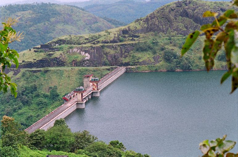
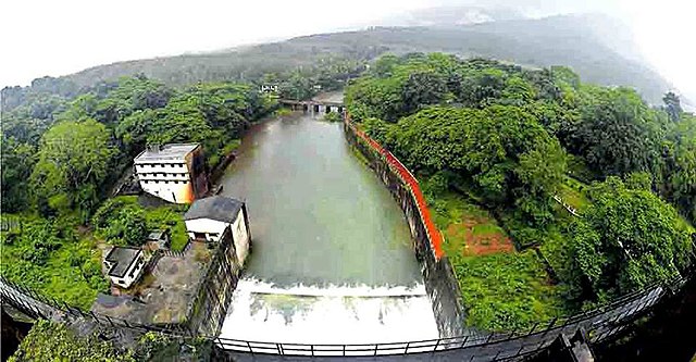
Cheruthoni Dam
The Cheruthoni Dam, located in Idukki District, Kerala, India, is a 138m tall concrete gravity dam. This dam was constructed as part of the Idukki Hydroelectric Project along with two other dams at Idukki and Kulamavu. The project was completed with Canadian aid. The Government of Canada aided the Project with long term loans and grants. S.N.C.Inc., Canada, a firm of Consulting Engineers were advising and assisting Project Engineers under the Canadian Aid.
The water impounded by these three dams of Idukki, Cheruthoni & Kulamavu has formed a single reservoir spread over 60 km on a height of 2300 ft above Mean Sea Level.The Idukki Dam is a double curvature arch dam constructed across Periyar River in a narrow gorge between two granite hills. Cheruthoni Dam is located 1 km west of Idukki dam. The spill way of the Idukki Reservoir is in the Cheruthony dam. Kulamavu Dam was constructed to prevent the water escape through a rivulet called Kalivally, 30 km west to Idukki Arch Dam. It is a 100 metres tall Masonry gravity dam. Construction of this Cheruthoni Dam, Idukki Arch Dam and Kulamavu Dam created an artificial lake of 60 km2 and the water stored, is used for production of electricity at the Moolamattom Power house. The power house at Moolamattom is the biggest underground power station in India and the pressure shaft is the largest in the country. Cheruthony is the largest and highest gravity dam in Kerala. Storage of water in Idukki Reservoir started in February, 1973. Moolamattom Power Station was Commissioned in February 1976 by Prime Minister Indira Gandhi.
Source : wikipedia https://www.youtube.com/watch?v=O7qQE8M4N8Y https://www.youtube.com/watch?v=I_Nfj93jjxE https://www.youtube.com/watch?v=D-536jne57o Reviews https://goo.gl/pnB3Lt
Chettikulangara Sree Bhagavathi temple is one of the most renowned Hindu temples in Kerala. The temple is located at Chettikulangara in Mavelikkara taluk of Alappuzha district in the south Indian state of Kerala. The temple is situated about 4 kilometres (2.5 mi) west of Mavelikara, 7 kilometres (4.3 mi) north of Kayamkulam on SH 6 (Kayamkulam – Thiruvalla Highway).
One important aspect of the Chettikulangara Sree Bhagavathi temple is that the deity appears as Maha Saraswathi in the morning, as Maha Lakshmi at noon and Sri Durga or Bhadrakali in the evening.
The temple has 13 “Karas”, or territories. The temple is at the centre of the oldest four Karas (Erezha South, Erezha North, Kaitha South and Kaitha North) and the rest of the Karas (Kannamangalam South, Kannamangalam North, Pela, Kadavoor, Anjilipra, Mattam North, Mattam South, Menampally and Nadakkavu) surround the temple, which is believed to be 1,200 years old.
The Thantric rights of the temple belongs to Plackudy Illom, With its Tharavadu (Base) in Ambalapuzha. Plackudy is one among the ancient Thantric families of Kerala.
Recently UNESCO collected details about the temple and its customs (Kuthiyottam, Kumbhabharani) in order to examine whether the temple is eligible for inclusion in the UNESCO World Heritage site.
Chi Lin Nunnery is a large Buddhist temple complex located in Diamond Hill, Kowloon, Hong Kong. It was founded in 1934 as a retreat for Buddhist nuns and was rebuilt in the 1990s following the traditional Tang Dynasty architecture. The Temple halls have statues of the Sakyamuni Buddha, the goddess of mercy Guanyin and other bodhisattvas. These statues are made from gold, clay, wood and stone.
The temple halls and the Chinese garden in front of the nunnery are open to the public daily free of charge.
The Chi Lin Nunnery uses the traditional Tang Dynasty architecture with a design based on a Sukhavati drawing in the Mogao Caves . It is constructed entirely with cypress wood, without the use of any nails, and is currently the world’s largest hand-made wooden building. This construction is based on traditional Chinese architectural techniques that uses special interlocking systems cut into the wood to hold them in place. The complex with 16 halls, a library, a school, a pagoda, a bell tower and a drum tower, covers an area of more than 33,000 square metres (360,000 sq ft). The Chi Lin Nunnery buildings are the only buildings to be built in this style in modern-day Hong Kong.
The Nan Lian Garden, located in the opposite of the Chi Lin Nunnery, is a Chinese Classical Garden also built in the style of the Tang dynasty. The scenic garden covers an area of 35,000 square metres (380,000 sq ft) is maintained by the Chi Lin Nunnery. In every hill, rock, body of water, plant and timber structure has been placed according to specific rules and methods.
Whether functioning as a school or a lifestyle and entertainment complex, it appears the beauty of CHIJMES is only equaled by its versatility.
So you’ve stumbled onto an enclave of restaurants and bars in the middle of the city. Except that it’s a quite different from the usual mall or restored shop houses.
No, CHIJMES (pronounced ‘chimes’) – with its green lawns, marble waterfalls, courtyards and neoclassical buildings – harks back to a bygone, more gracious age.
Once a school and chapel
Photo by Sanjay Kewlani – www.skewedeye.com
It makes sense when you realise it used to be a Catholic school for girls.
CHIJMES began with one building – Caldwell House – which was designed by prominent colonial architect George Coleman (who also designed Old Parliament House) as a home for a Senior Magistrate’s clerk.
The property was bought over by Father Beurel in 1853, in addition to surrounding parcels of land, for the purpose for building a girls’ school.
Other structures slowly sprung up around Caldwell House, most notably a grand Anglo-French Gothic chapel in 1904. One of the most elaborate places of worship in Singapore, its intricate plasterwork, wall frescoes and Belgian stained glass windows still inspire wonder today.
Peaceful oasis
Photo by Sanjay Kewlani – www.skewedeye.com
Check out the capitals at the top of each chapel column – each one bears a unique impression of tropical flora or birds.
The complex also used to house an orphanage. Look out for The Gate of Hope, which still stands on Victoria Street, where unwanted babies were left for the nuns to take care of.
Despite the exciting dining and nightlife options it houses today, CHIJMES retains a sense of tranquility and harmony, making it a peaceful oasis amid the bustle of the city.
Chimmini Dam Road, Dist. Thrissur, Pariyaram, Kerala 680304
Phone: +91 487 2699017
Mobile:9447979103
Image Credit : wikipedia
Chimmini Wildlife sanctuary is a protected area located along the Western Ghats in Chalakudy taluk of Thrissur District of Kerala state in India.
The sanctuary is an important bird area with 192 recorded avian species. Five Western Ghats endemic bird species occur here, including the grey-headed bulbul (Pycnonotus priocephalus), Indian rufous babbler (Turdoides subrufus) and white-bellied blue-flycatcher (Cyornis pallipes). Other interesting species found here include-Ceylon frogmouth (Batrachostomus moniliger), Indian edible-nest swiftlet (Collocalia unicolor), Malabar trogon (Harpactes fasciatus), Malabar whistling-thrush (Myiophonus horsfieldii) and Loten’s sunbird (Nectarinia lotenia) (Islam and Rahmani 2004). A recent survey recorded the presence of the lesser fish eagle (Ichthyophaga humilis), which until recently was only known from the foothills of the Himalayas.
Other significant sightings during the survey included those of the large hawk cuckoo (Cuculus sparverioides), broad-billed roller (Eurystomus orientalis) and ashy minivet (Pericrocotus divaricatus). About half of the large mammals found in Kerala are reported from Chimmini Wildlife Sanctuary, especially some of the globally threatened species such as tiger (Panthera tigris), Asian elephant (Elephas maximus) and wild dog (Cuon alpinus). Other red-listed species found here include the Indian giant squirrel (Ratufa indica) and the endemic primates-lion-tailed macaque (Macaca silenus), Nilgiri langur (Trachypithecus johnii) and slender loris (Loris lydekkerianus). There are 39 species of mammals, 160 species of birds, 25 species of reptiles, 14 species of amphibians, and 31 species of fishes are reported from the sanctuary.
source : wikipedia https://www.youtube.com/watch?v=zOifIB93wL0 https://www.youtube.com/watch?v=h3DGNpEfMT4 https://www.youtube.com/watch?v=N99dV3Ivk2A Reviews https://bit.ly/3bTtITb Visiting hours : 08.00 am to 05.00 pm Entry :https://bit.ly/34iQKyC
Click On the Headlines or Image for the complete News, Videos and more Photos.
China–North Korea relations (Korean: 조중 관계) are bilateral between the People’s Republic of China (PRC) and the Democratic People’s Republic of Korea (DPRK or North Korea).
China maintains an embassy in the North Korean capital of Pyongyang and a consulate general in Chongjin. The Embassy of North Korea in China is located in Beijing’s Chaoyang District, while a consulate general is in Shenyang.
China and North Korea have, in the past, enjoyed close diplomatic relations. However, China–North Korea relations have declined markedly over the past few years. The decline in China–North Korea relations is primarily due to growing concern in China over issues such as North Korea’s nuclear weapons program and its impoundment of Chinese fishing boats.
Favorable views of North Korea among Chinese people appear to be receding as well. According to a 2014 BBC World Service Poll, 20% of Chinese people view North Korea’s influence positively, with 46% expressing a negative view.
Source : wikipedia
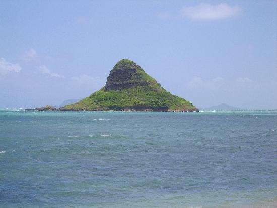
This photo of Oahu is courtesy of TripAdvisor
Mokolii, commonly known as Chinaman’s Hat, is a basalt islet in Kāneʻohe Bay, Hawaii. Mokoliʻi is part of Kualoa Regional Park and located 1⁄3 mile (0.54 km) offshore of Kualoa Point, Oahu. The 12.5-acre (5.1 ha) islet was at one time part of a basaltic ridge on Oahu before marine erosion separated it
Mokoliʻi translates from Hawaiian as “little lizard.” According to Hawaiian mythology, the island is the remains of a giant lizard’s or dragon’s tail that was chopped off and tossed into the ocean by the goddess Hiʻiaka.[2] The common name of Chinaman’s Hat derives from its likeness to the Asian conical hat.
Both wildlife and plants of Mokolii have been affected by the presence of non-native species, in particular the black rat and yellow crazy ant. Although other species of birds previously nested there, the Wedge-tailed shearwater is the only species of bird that nests on Mokolii. 72 species of plants have been identified, the majority of which are invasive non-native species. Native plants thrive in the coastal margins and include ahu awa (Cyperus javanicus), naupaka (Scaevola taccada), and ilima (Sida fallax). Invasive plants which dominate the slopes are Lantana camara, Spanish needles (Bidens alba var. radiata), and christmasberry. The island was designated as a critical habitat for Carter’s panicgrass (Panicum fauriei var. carteri) by the U.S. Fish and Wildlife Service (USFWS) in 1983. In 2002, the USFWS initiated a program to eradicate rats from Mokolii.
Chinatown is a subzone and ethnic enclave located within the Outram district in the Central Area of Singapore . Featuring distinctly Chinese cultural elements, Chinatown has had a historically concentrated ethnic Chinese population.
As the largest ethnic group in Singapore is Chinese, Chinatown is considerably less of an enclave than it once was. However, the precinct does retain significant historical and cultural significance. Large sections of it have been declared national heritage sites officially designated for conservation by the Urban Redevelopment Authority.
Singapore’s Chinatown is known as Niu che shui ( in Chinese literally: “cow car water”) in Mandarin, Gu Chia Chwi in Hokkien and Ngau-che-shui in Cantonese – all of which mean “bullock water-cart” – and Kreta Ayer in Malay, which means “water cart”. This is due to the fact that Chinatown’s water supply was principally transported by animal-driven carts in the 19th century. It should be noted that while these names are sometimes used for referring to Chinatown in general, they actually refer to the area of Kreta Ayer Road.
The street architecture of town’s buildings, the shop houses especially, combine different elements of baroque architecture and Victorian architecture and do not have a single classification. Many of them were built in the style of painted ladies, and have been restored in that fashion. These styles result in a variety of different colours of which pastel is most dominant. Trengganu Street, Pagoda Street and Temple Street are such examples of this architecture, as well as development in Upper Cross Street and the houses in Club Street. Boat Quay was once a slave market along the Singapore River, Boat Quay has the most mixed-style shop houses on the island.
The architectural character of many of the terraces in Chinatown is much more Italianate in style than those of, for instance Emerald Hill or Petain Road. Windows often appear as mere slits with narrow timber jalousies (often with adjustable slats). Fanlights over the windows are usually quite decorative and the pilasters and balconies and even the plaster work and colours seem to be Mediterranean in flavour. The style was probably introduced by those early Chinese immigrants (both China-born and Straits-born) who had knowledge of the Portuguese architecture of Macau, Malacca and Goa. The Chettiars and Tamils from Southern India would also have been familiar with the European architecture there, although it is difficult to imagine how these people would have had a particularly strong influence on building in Chinatown.
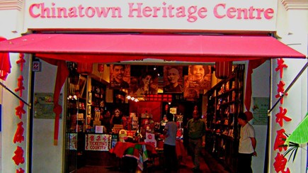
Experience how Singapore’s early Chinese migrants once lived and learn more about local Chinese culture at the Chinatown Heritage Centre.
Discover Chinatown Heritage Centre
Photo by Chinatown Heritage Centre Pte Ltd
Step back in time at Chinatown Heritage Centre and retrace the footsteps of some of Singapore’s early pioneers.
Set within three beautifully-restored shophouses on Pagoda Street, the Chinatown Heritage Centre recreates the original interiors of the 1950s, offering a rare glimpse into the lives of Chinatown’s early residents.
Photo by Chinatown Heritage Centre Pte Ltd
At the centre you can explore the living quarters, shops and even nightlife of these early settlers. Every object here tells a story, providing a fascinating insight into some of the people who helped build this modern city.
Photo by Chinatown Heritage Centre Pte Ltd
You can retrace the journey of those who left their villages in China to escape famine, floods and unrest and headed to Singapore to seek a better life. Most of them settled south of the Singapore River, giving birth to Chinatown.
Many of them risked their lives to get here, and you’ll be able to get a first-hand view of what they endured as you explore the cosy rooms and narrow passages of the building.
Photo by Chinatown Heritage Centre Pte Ltd
The centre reopened in early 2016 after an extensive refurbishment, providing new temporary exhibition areas and space for community events. Even better, you can now sample renowned local food at Old Chang Kee’s Curry Times, and pick up limited edition souvenirs by local designers such as Doe & Audrey and My Paper Earrings.
The refurbished centre also brings the Chinatown story up to date, with new exhibitions on the area from the 1960s onwards. It also features the fascinating tale of the Kongs, a family who used to live in the exact same building before it was transformed into the heritage centre you can enjoy now.
There has never been a better time to visit the Chinatown Heritage Centre. Don’t forget to pick up a souvenir on your way out!
A tranquil patch of imperial China in the west of Singapore is pleasant respite from the bustle of the city.
At the entrance of Chinese Japanese Gardens, you’ll find a pair of majestic stone lions guarding its gates. Statues of these proud creatures have traditionally stood in front of imperial palaces, tombs and temples in ancient China for their mythical ability to protect.
Indeed the 13.5-hectare Chinese Japanese Gardens feels like a slice of ancient China transplanted to the west of Singapore, complete with a series of stone bridges, pagodas and a tea house.
Designed by Taiwanese architect Prof. Yuen-chen Yu and built in 1975, the space is modeled after the northern Chinese imperial style of architecture and landscaping, particularly during the Sung dynasty period. The ‘Bai Hong Qiao’ bridge, for instance, follows the style of the 17-Arch Bridge at the Summer Palace in Beijing. Other highlights include a Bonsai Garden, which houses a collection of over a hundred beautifully-manicured bonsais imported from Malaysia, China, Taiwan, Japan, Philippines, Indonesia, and Thailand.
Meanwhile, kids will delight at the Live Turtle And Tortoise Museum, which is home to more than 200 turtles and tortoises in over 60 different species.
The usually tranquil grounds burst into life during traditional Chinese festivals like Chinese New Year and the Mid-Autumn Festival.
A stroll through the meandering footpaths is a nice change of pace from the bustling city. And if you can’t get enough of the serenity of the Chinese Garden, simply cross over to the nearby Japanese Garden, a model of Japanese gardens from the middle ages.
River Rd, Fort Kochi, Kochi, Kerala 682001
Phone: 090371 18749
Image Credit : commons.wikimedia.org
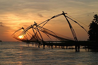
The huge cantilevered Chinese fishing nets that droop towards the waters like over-sized hammocks have become a hallmark that represents Fort Kochi on the tourist map. Once just a fishing accessory, it is a now a big bait for tourists.
History
Chinese fishing nets – Cheenavala in Malayalam – is believed to have been introduced in Kochi by Chinese explorer Zheng He, from the court of the Kubla Khan. The fishing net established itself on the Kochi shores between 1350 and 1450 AD.
Best view
The sight of the Chinese nets, suspended in mid air and standing in line on the beaches, when silhouetted against the sunset is breathtakingly beautiful. It is, undoubtedly, one of the most photographed sights in Kochi.
For the best view of the nets, head to the Vasco da Gama Square, the narrow walkway that runs along the Fort Kochi beach.
Structure and working of Chinese fishing nets
The Chinese nets, made of teak wood and bamboo poles, work on the principle of balance. Each structure, about 10m high, is fixed on the beach and has a cantilever with an attached net that is spread over an area of about 20 meters. Counterweights, usually stones about 30 cm in diameter, tied to ropes of different lengths, facilitate the working of the nets. Often, lights, attached to the teak posts. are suspended above the net to attract fish.
Each fishing net is operated by more than four fishermen and is made in such a way that the weight of a man walking on the main plank is enough to cause the equipment to be pulled down into the sea. Fishing is usually done in the morning and early evening. The net is descended into the water for a short time and then raised delicately by pulling on the ropes. The slow rhythm and balancing of the net is spellbinding to a first-time viewer.
Source : keralatourism.org
Chinnar Wildlife Sanctuary (CWS) is located 18 km north of Marayoor on SH 17 in the Marayoor and Kanthalloor panchayats of Devikulam taluk in the Idukki district of Kerala state in South India. It is one of twelve wildlife sanctuaries among the protected areas of Kerala.
Settlements and crops
There are 11 tribal settlements inside the Chinnar WLS, each is well demarcated by temporary stone walls. The main inhabitants are Muthuvas and Pulayars. Cultivation of maize, ragi and lemongrass is practiced in the settlements. The Mudhuvas carry out small scale ganja cultivation for their religious purposes.
Fauna
34 species of mammals live here, including many panthers and spotted deer, 50 -60 Indian elephants, gaur, tigers, sambar deer, common langur, bonnet macaque, Hanuman monkey, threatened Nilgiri tahr, vulnerable rusty-spotted cats and about 240 of the only vulnerable grizzled giant squirrels in Kerala. 245 species of birds including yellow-throated bulbuls. 52 species of reptiles including 29 species of snakes, Indian star tortoise and the largest population of vulnerable mugger crocodiles in Kerala live in the sanctuary. Most common of the 42 species of fishes observed in the Chinnar and Pambar rivers are Garra mullya minnows, river-carp baril, giant danio and the endangered hill stream game fish Deccan mahseer. 22 amphibian species live in the sanctuary. There are 156 species of butterflies. Recently, 101 species of spiders were discovered here.
Flora
There are 965 species of flowering plants in the sanctuary Ecoregions of the sanctuary comprise mostly grassland and wet grasslands vegetation and some South Western Ghats montane rain forests and high shola at the higher western elevations. South Western Ghats moist deciduous forests at mid elevations give way to dry deciduous forests and thorny scrub forests in the lower dryer eastern edges of the valley. The major xerophyticspecies in the throny scrub forests are Acacia arabica, Acacia leucofolia, Acacia concinna, Prosporis juliflora, and Opuntia stricta.
Chittorgarh Fort Village, Chittorgarh, Rajasthan 312001
Phone: 094137 91906
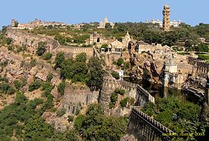
This is a World heritage site.
Chittorgarh Fort one of the largest forts in India. The fort, popularly known as Chittor, was the capital of Mewar and is today situated in Chittorgarh. It was initially ruled by Guhilot and later by Sisodias, the Suryavanshi clans of Chattari Rajputs, from the 7th century, until it was finally abandoned in 1568 after the siege by Emperor Akbar in 1567. It sprawls majestically over a hill 180 m (590.6 ft) in height spread over an area of 280 ha (691.9 acres) above the plains of the valley drained by the Berach River. The fort precinct with an evocative history is studded with a series of historical palaces, gates, temples and two prominent commemoration towers. These monumental ruins have inspired the imagination of tourists and writers for centuries.
The fort was sacked three times between the 15th and 16th centuries; in 1303 Allaudin Khilji defeated Rana Ratan Singh, in 1535 Bahadur Shah, the Sultan of Gujarat defeated Bikramjeet Singh and in 1567 Emperor Akber defeated Maharana Udai Singh II who left the fort and founded Udaipur. Each time the men fought bravely rushing out of the fort walls charging the enemy but lost every time. Following these defeats, Jauhar was committed thrice by more than 13,000 ladies and children of the Rajput heroes who laid their lives in battles at Chittorgarh Fort, first led by Rani Padmini wife of Rana Rattan Singh who was killed in the battle in 1303, and later by Rani Karnavati in 1537 AD.
Thus, the fort represents the quintessence of tribute to the nationalism, courage, medieval chivalry and sacrifice exhibited by the Mewar rulers of Sisodia and their kinsmen and women and children, between the 7th and 16th centuries. The rulers, their soldiers, the women folk of royalty and the commoners considered death as a better option than dishonor in the face of surrender to the foreign invading armies.
In 2013, at the 37th session of the World Heritage Committee held in Phnom Penh, Cambodia, Chittorgarh Fort, along with 5 other forts of Rajasthan, was declared a UNESCO World Heritage Site under the group Hill Forts of Rajasthan.
It is better to engage a guide as there are lot of things to be explained. For example Rani Padmini allowed Alauddin to see her reflection on a mirror. Only a guide can explain and show you the place where Alauddin saw her reflection on a mirror.
Visiting hours : Morning to Evening all days of the week
Entry fee : Rs. 10/- for Indians and Rs. 100/- for foreign tourists
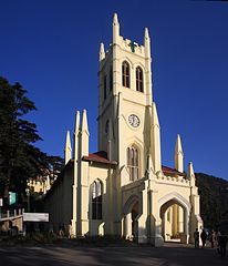
Christ Church, Shimla, is the second oldest church in North India, after St. John’s Church in Meerut . Worship is conducted in Hindi and English.
Built in the neo-Gothic style in 1857 to serve the largely Anglican British community in what was formerly called Simla, it is situated on The Ridge where it stands out as one of the prominent landmarks of Shimla. The silhouette of Christ Church is visible for miles around the vicinity of Shimla city. the Church remains one of the enduring legacies of the British Raj.
Christ Church was designed by Colonel J. T. Boileau in 1844, and the church was consecrated after 1857. The clock adorning the Church was donated by Colonel Dumbleton in 1860. The porch was added in 1873.
Christ Church has survived Partition and the subsequent political upheavals on the Indian subcontinent. The Church continues to be very well maintained and remains in good condition. The clock, however, no longer functions – due to entropy.
It is designed in the typical Elizabethan style. The church is lit at night to illuminate it. It looks absolutely magical during night when lights placed at strategic corners illuminate this beautiful church. The church glows with all its beauty and grandeur and is an amazing sight to look at.
The church contains five fine stained glass windows. One represents the Christian virtues of Faith, Hope, Charity, Fortitude, Patience and Humility. The pipe-organ of Christ Church is the biggest in the Indian subcontinent and was installed in September 1899.
Among the church’s holdings are a great collection of books and ancient scriptures.
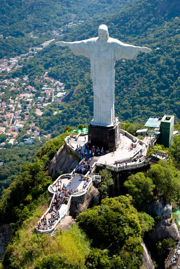
Address :Parque Nacional da Tijuca – Alto da Boa Vista, Rio de Janeiro – RJ, Brazil
Christ the Redeemer is an Art Deco statue of Jesus Christ in Rio de Janeiro, Brazil, created by French sculptor Paul Landowski and built by Brazilian engineer Heitor da Silva Costa, in collaboration with French engineer Albert Caquot. Romanian sculptor Gheorghe Leonida fashioned the face. Constructed between 1922 and 1931, the statue is 30 metres (98 ft) high, excluding its 8-metre (26 ft) pedestal. The arms stretch 28 metres (92 ft) wide. It is made of reinforced concrete and soapstone.
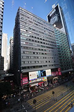
36–44 Nathan Road in Tsim Sha Tsui, Kowloon, Hong Kong.
Chungking Mansions is a building located at 36–44 Nathan Road in Tsim Sha Tsui, Kowloon, Hong Kong. The building is well known as nearly the cheapest accommodation in Hong Kong. Though the building is supposedly residential, it is made up of many independent low-budget hotels, shops and other services. The unusual atmosphere of the building is sometimes compared to that of the former Kowloon Walled City.
Chungking Mansions features guesthouses, curry restaurants, African bistros, clothing shops, sari stores, and foreign exchange offices. It often acts as a large gathering place for some of the ethnic minorities in Hong Kong, particularly South Asians (Indians, Nepalese, Pakistanis, Bangladeshis and Sri Lankans), Middle Eastern people, Nigerians, Europeans, Americans, and many other peoples of the world. Peter Shadbolt of CNN stated that the complex was the “unofficial African quarter of Hong Kong”.
The building was completed in 1961, at which time Chinese residents predominated. Now, after more than five decades of use, there are an estimated 4,000 people living in the complex.
Chungking Mansions is 17 storeys tall and consists of five blocks, A, B, C, D and E.
There are two lifts in each block, one of which serves even-numbered floors, the other odd-numbered floors. A CCTV camera system exists at the ground floor level for each of the lift cars.
The first two floors are common space where you can wander around under the blocks; the third floor is actually a terrace level between the blocks where the tower blocks start to rise out of the base of the building; and all floors above this are accessible only by the stairways and lifts contained in each block.
The separate Cke Shopping Mall, a few metres to the north of the main entrance, however protrudes into the 3rd floor of blocks A and B.
Churdhar Sanctuary is located in Sirmour, Shimla district of the Indian state of Himachal Pradesh.
The sanctuary is named after the Churdhar Peak. Churdhar (elevation of 3,647 metres; 11,965 feet) is the highest peak in Sirmour district and is also the highest peak in the outer Himalayas. The peak has a great religious significance for the people of Sirmour, Shimla, Chaupal and Solan of Himachal Pradesh and Dehradun of Uttrakhand. Churdhar is a holy place related with Shri Shirgul Maharaj (Chureshwar Maharaj), a deity widely worshipped in Sirmour and Chaupal. The place can be approached by lots of routes but the main routes are from Nohradhar, Sirmour of 14 km and Sarahan, Chaupal of 8 km.
The Churdhar Peak is mentioned in the book, The Great Arc, by John Keay but is referred to as The Chur. It is from this peak that George Everest made many astronomical readings and sightings of the Himalaya mountains around 1834. He was the Surveyor General of India and did the initial survey of the full length of India as well as some very accurate measurements of the earth’s curvature.
Jalebi Chowk, Near Jantar Mantar, Tripolia Bazar, Jaipur, Rajasthan 302002
Phone : 0141 408 8855
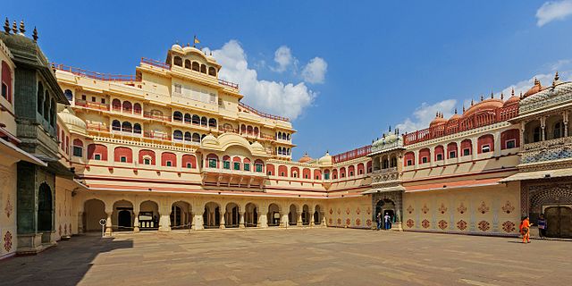
City Palace, Jaipur, which includes the Chandra Mahal and Mubarak Mahal palaces and other buildings, is a palace complex in Jaipur. It was the seat of the Maharaja of Jaipur, the head of the Kachwaha Rajput clan. The Chandra Mahal palace now houses a museum but the greatest part of it is still a royal residence. The palace complex, located northeast of the centre of the grid-patterned Jaipur city, incorporates an impressive and vast array of courtyards, gardens and buildings. The palace was built between 1729 and 1732, initially by Sawai Jai Singh II, the ruler of Amber. He planned and built the outer walls, and later additions were made by successive rulers continuing up to the 20th century.
The site for the palace was located on the site of a royal hunting lodge on a plain land encircled by a rocky hill range, five miles south of Amber (city). The history of the city palace is closely linked with the history of Jaipur city and its rulers, starting with Maharaja Sawai Jai Singh II who ruled from 1699-1744. He is credited with initiating construction of the city complex by building the outer wall of the complex spreading over many acres. Initially, he ruled from his capital at Amber, which lies at a distance of 11 kilometres (6.8 mi) from Jaipur. He shifted his capital from Amber to Jaipur in 1727 because of an increase in population and increasing water shortage. He planned Jaipur city in six blocks separated by broad avenues, on the classical basis of principals of Vastushastra and other similar classical treatise.
Following Jaisingh’s death in 1744, there were internecine wars among the Rajput kings of the region but cordial relations were maintained with the British Raj. Maharaja Ram Singh sided with the British in the Sepoy Mutiny or Uprising of 1857 and established himself with the Imperial rulers. It is to his credit that the city of Jaipur including all of its monuments (including the City Palace) are stucco painted ‘Pink’ and since then the city has been called the “Pink City”. The change in colour scheme was as an honour of hospitality extended to the Prince of Wales (who later became King Edward VII) on his visit. This colour scheme has since then become a trademark of the Jaipur city.
Man Singh II, the adopted son of Maharaja Madho Singh II, was the last Maharaja of Jaipur to rule from the Chandra Mahal palace, in Jaipur. This palace, however, continued to be a residence of the royal family even after the Jaipur kingdom merged with the Indian Union in 1949 (after Indian Independence in August 1947)
The City Palace is laid in a grid pattern with wide avenues. It is a unique and arresting complex of several palaces, pavilions, gardens and temples. The most prominent and most visited structures in the complex are the Chandra Mahal, Mubarak Mahal, Mukut Mahal, Maharani’s Palace, Shri Govind Dev Temple and the City Palace Museum.
Front View of the City PalaceCity PalaceFull View of the city Palace
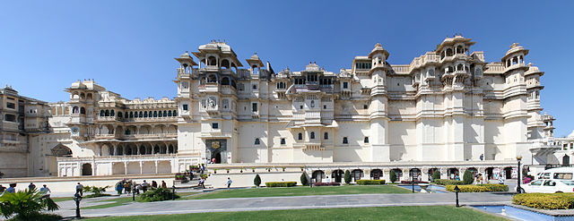
City Palace Udaipur, is a palace complex in Udaipur. It was built over a period of nearly 400 years being contributed by several kings of the dynasty, starting by the Maharana Udai Singh II as the capital of the Sisodia Rajput Clan in 1559, after he moved from Chittor. City Palace Udaipur is located on the east bank of the Lake Pichola and has several palaces built within its complex. Udaipur was the historic capital of the former kingdom of Mewar in the Rajputana Agency and its last capital.
The City Palace Udaipur was built in a flamboyant style and is considered the largest of its type in Rajasthan, a fusion of the Rajasthani and Mughal architectural styles, and was built on a hill top that gives a panoramic view of the city and its surrounding, including several historic monuments such as the Lake Palace in Lake Pichola, the Jag Mandir on another island in the lake, the Jagdish Temple close to the palace, the Monsoon Palace on top of an overlooking hillock nearby and the Neemach Mata temple. These structures are linked to the filming of the James Bond movie Octopussy, which features the Lake Palace and the Monsoon Palace. The subsequent publicity has resulted in the epithet of Udaipur as “Venice of the East”. In 2009, Udaipur was rated the top city in the World’s Best Awards by Travel + Leisure.
Architecture
The series of palaces in the City Palace Udaipur complex, behind an exquisite facade of 244 metres (801 ft) length and 30.4 metres (100 ft) height, were built on a ridge on the east of lake Pichola. The complex is located in Udaipur city at an average elevation of 598 metres (1,962 ft). They were built over a long period, from 1559 onwards, by 76 generations of Sisodia Rajputs .Several Maharanas starting with Udai Singh II, have contributed to this edifice, which comprises an agglomeration of structures, including 11 small separate palaces. The unique aspect of this conglomeration is that the architectural design is distinctly homogeneous . The City Palace Udaipur complex has been built entirely in granite and marble. The interiors of the palace complex with its balconies, towers and cupolas exhibit delicate mirror-work, marble-work, murals, wall paintings, silver-work, inlay-work and leftover of colored glass. The complex provides a view of the lake and the Udaipur city from its upper terraces.
The palaces within the complex are interlinked through a number of chowks or quadrangles with zigzag corridors, planned in this fashion to avoid surprise attacks by enemies. Erected in the complex, after entering through the main Tripolia (triple) gate, are the Suraj Gokhda (public address facade), the Mor-chowk (Peacock courtyard), the Dilkhush Mahal (heart’s delight), the Surya Chopar, the Sheesh Mahal (Palace of glass and mirrors), the Moti Mahal (Palace of Pearls), the Krishna Vilas (named after Lord Krishna), Shambu Niwas (royal residence now), the Bhim Vilas, the Amar Vilas (with a raised garden) that faces the Badi Mahal (the big palace), the Fateprakash Palace and the Shiv Niwas Palace; the last two have been converted into heritage hotels. The complex is set with facilities of a post office, bank, travel agency, numerous craft shops and also an Indian boutique belonging to the World Wildlife Fund (WWF) . The entire complex is the property of the Mewar royal family with various trusts maintaining the structures.
There is a gallery reflecting the rich saga of Rana Pratap Singh. The gallery displays the war ornaments used by Rana Pratap and his horse Chetak. The 25 Kg weight sword used by Rana Pratap Singh is displayed here. Rana Pratap use to carry two swords with him always. Before any fight he uses to offer one sword to his opponent if he is not armed. His horse ornaments include one artificial elephant trunk used to confuse opponent elephants as baby elephants as elephants don’t attack baby elephants.
One big picture of Rana Pratap vertically killing a Mogul soldier along with his horse into two pieces in one stroke of his sword is displayed inside this gallery. Pigeon cages are kept in a hall, pigeons are used to send messages in those days. Narrow walkways and entrance to rooms and steps were constructed even though the Marana families were tall in height to prevent rush of enemies or attackers suddenly inside the palace. Another reason was all has to enter to Kings Area with head down.
Maharana Karan Singh had added fine peacocks constructed in relief mosaic. These peacocks are kept inside glass windows for the tourist to watch the colorful design. This place is known as Mor Cowk.
Zenana Mahal women’s quarter was constructed for women. There are beautiful antique furniture displayed inside the halls. Kerosene operated table fan is kept in the main meeting place for the women.
Pictures of king hunting and their royal living styles are displayed in different paintings.
Maharana Karan Singh constructed a portion of the palace known as Dil Khushal with mirror glass designs and miniature paintings fitted all along the walls and roofs.
Maharanas of Mewar are Surya Vanshi or decedents of Sun god. So they daily pray the sun god. One big sun god status made of Gold is available inside the palace and the kings use to perform puja here on the cloudy days when sun god is not visible. Outside the Palace there is another status of Sun God for general public to offer other pujas.
There is a beautiful courtyard with decorative structures for light fittings is available for booking to organize functions.
View of Lake Pichola and Lake Palace is available from the palace.
Passeig de Picasso, 21, 08003 Barcelona, Spain
Province: Barcelona
Phone: +34 638 23 71 15
Image Credit : wikipedia
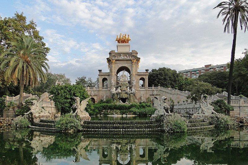
The Parc de la Ciutadella (“Citadel Park”) is a park on the northeastern edge of Ciutat Vella, Barcelona, Catalonia, Spain. For decades following its creation in the mid-19th century, this park was the city’s only green space. The 70-acre (280,000 m2) grounds include the city zoo (once home to the albino gorilla Snowflake, who died in 2004), the Palau del Parlament de Catalunya, a small lake, museums, and a large fountain designed by Josep Fontserè (with possible contributions by the young Antoni Gaudí).
The Cascada (waterfall or cascade in Spanish) is located at the northern corner of the park opposite to the lake.
The zoo of Barcelona is located in the park of the ciutadella due to the availability of a few buildings which were left empty after the Universal Exposition of 1888. It was inaugurated in 1892, during the day of the Mercé, the patron saint of the city. The first animals were donated by Lluís Martí i Codolar to the municipality of Barcelona, which gratefully approved of their accommodation in the zoo.
Nowadays, with one of the most substantial collections of animals in Europe, the zoo affirms that their aim is to conserve, investigate, and educate.
From 1966 to 2003 the zoo was home to the famous albino gorilla Snowflake, who attracted many international tourists and locals.
The Museum of Natural Sciences of Barcelona comprises a museum of zoology and a museum of geology, both sited in the park, but also other science facilities elsewhere in Barcelona.
Pengkalan Weld, 10300 George Town, Pulau Pinang, Malaysia
Source : visitpenang.gov.my
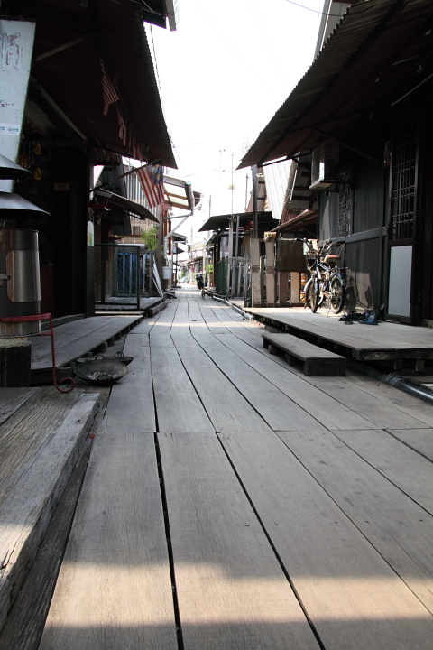
Penang being a heritage town is rich with attractive historic sites and cultural events, but this inimitable settlement stands out as a truly unique living heritage. The Chew Jetty is actually a whole settlement of wooden houses built on silts and the name “Chew” is the surname (the first name) of the residences and that’s where the name was derived. Migrant’s families with this surname would live together in this area.
These clusters of wooden houses were built by the Chinese poor immigrants who work near the port during the nineteen century. These immigrants migrated from the south-eastern coast of China, known as the Fujian Province over here due to the hardship they face in their homeland during that era. Later they brought their families over and made this waterfront their home. The Chew Jetty is still home to hundreds of people living in this area today but many have changed their social and economic lifestyle.
Source : visitpenang.gov.my
Clan Jetties and their Floating Village is a complete village on stilts above the water where Chinese clans live. In the 19th century many Chinese immigrants came to Malaysia. To enlarge their chances clans were established, There used to be seven jetties until one was demolished by fire and now six remain.
The small villages are characterized by old traditions and habits, from candles outside the door to complete prayer temples inside the house. In total there are six of these villages, in every village lives one clan, and every village has their own temple. . Each jetty is named after a Chinese clan – the Chew Jetty is the most tourist-friendly with the most stilt-houses, the longest walkway, a temple that is worth stopping by and plenty of places for those Kodak moments.
Those who are staying here does not pay any tax as they are not living on land.
Getting there : The clan jetties are within walking distance of the Weld Quay Bus Terminal, so it can easily be reached by bus, taxi and ferry. The Penang Hop-OnHop-Off Tourist Bus also stops there.
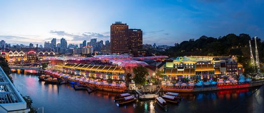
Clarke Quay is a historical riverside quay in Singapore, located within the Singapore River Planning Area. The quay is situated upstream from the mouth of the Singapore River and Boat Quay.
At present, five blocks of restored warehouses house various restaurants and nightclubs. There are also moored Chinese junks (tongkangs) that have been refurbished into floating pubs and restaurants. The Cannery is one of the anchor tenants of the place. There are over 5 different concepts in one block. Another anchor tenant, The Arena, will be home to Singapore’s First Permanent Illusion Show (starting August 2008) starring J C Sum and ‘Magic Babe’Ning . The G-MAX reverse bungee , the first in Singapore, is located at the entrance which opened in November 2003. Notable restaurants and nightclubs include Hooters and Indochine. River cruises and river taxis on the Singapore River can be accessed from Clarke Quay. One of its most popular attractions is its exciting host of CQ’s signature events happening once every quarter. Clark Quay has become known as a hub of Singaporean nightclubs including Zirca, and up until 2008, the Ministry of Sound.
Clarke Quay is also the name of a road along the quay, part of which has since been converted into a pedestrian mall. Clarke Street, located next to Clarke Quay, was officially named in 1896, and was originally two streets known simply as East Street and West Street in north Kampong Malacca. Similar to Clarke Quay, Clarke Street has since been converted into a pedestrian mall.
The Hoklos (Hokkien) refer to Clarke Street as gi hok kong si au, meaning “behind the new Gi Hok Kongsi” (house). The new Gi Hok Kongsi was near Carpenter Street. Another Chinese reference, which only refers to the Southern bank around Read Bridge area, was cha chun tau , meaning “jetty for boats carrying firewood”. Small tongkangs carrying firewood from Indonesia berthed at this jetty. The firewood trade was primarily a Teochew enterprise.
Click On The URL Or PICTURE for the complete News, Videos and more photos.
Futuristic and disruptive
Despite, or perhaps because of, its simple design, the shipping container is one of the most disruptive inventions of the past century.
It allows cargo to be moved cheaply from one mode of transport to another and has facilitated the development of the complex supply chains all modern economies rely on.
Transfer from truck to giant cargo ship to freight train is seamless and the container can be used again and again, drastically reducing the cost of long-distance shipping.
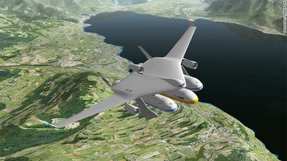
That’s the magic of inter-modal transport — and it’s something the futuristic and potentially game-changing Clip-Air concept hopes to emulate.
Clip-Air is composed of two elements.
There’s the flying component, including airframe, cockpit and engines.
Then there’s the capsules, a number of detachable pods that can act as cabin or cargo hold, depending on the chosen configuration.
The airframe is based on a flying-wing concept, reminiscent of a stealth bomber. Some may even find some similarities to the X-48, an experimental pilotless aircraft developed for NASA a decade ago.
Versatile design
A pair of long metal legs protruding from each side of the flying wing, and containing the landing wheels mechanism, keep the airframe high above the ground.
The height is to allow for capsules to be hung from the belly of the aircraft, not unlike the way warplanes carry bombs and missiles.
These capsules could be made to carry either passengers or cargo.
In fact, while Clip-Air’s speed and range is expected to be on a par with that of modern mid-sized airliners, the beauty of the concept rests precisely upon the versatility provided by the capsules.
These modules can be adapted to simultaneously carry a wide range of cargo and passenger combinations.
One single aircraft would be able to perform multiple roles.
The capsules can also be easily attached and detached from the airframe, making it possible for aircraft to achieve very quick rotations on the ground.
Claudio Leonardi, who manages the Clip-Air project at the Federal Polytechnic Institute in Lausanne, says this’ll allow operators to maximize use of the airframe, the most expensive component…………………………………
Ghanta Ghar, also known as the clock tower Jodhpur located 2kms. from the railway station, was built by Maharaja Sardar Singh (1880-1911) from whom the market takes its name. Cloak Tower is the major landmark in Jodhpur and the area around is a vibrant market place which offers an exciting shopping experience. Here you can find the finest variety of spices. Mathaniya’s red chili is famous for its dark red colour and is a must buy. Other things are hand embroidered fabrics, handicrafts and antiques. Rajasthani delicacies, Makhania Lassi, Shahi Samosa and omelets are the main attractions here.
Kollam Clock Tower is a landmark in Kollam City in the Indian state of Kerala. Situated in the city center at Chinnakada, the tower lies in the heart of the city, close to Kollam Junction Railway Station. As the first clock tower in the erstwhile Travancore state, it has now become a non-official emblem of the entire city and the major landmark of Kollam. The quadrangular clock tower was built in 1944 by the natives as a tribute to Unichakam Veedu K G Parameshwaran Pillai, the former chairman of Kollam Municipality from 1932–48. Construction of the tower began in 1941 and was completed three years later in brick and white cement. The tower has four clocks facing the four directions of the city, which were brought from Kolkota, the origin can be traced to Britain.
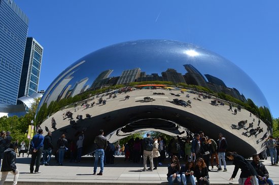
201 E Randolph St, Chicago, IL 60602
This photo of Cloud Gate is courtesy of TripAdvisor
This photo of Cloud Gate is courtesy of TripAdvisor
Cloud Gate is a public sculpture by Indian-born British artist Sir Anish Kapoor, that is the centerpiece of AT&T Plaza at Millennium Park in the Loop community area of Chicago, Illinois. The sculpture and AT&T Plaza are located on top of Park Grill, between the Chase Promenade and McCormick Tribune Plaza & Ice Rink. Constructed between 2004 and 2006, the sculpture is nicknamed The Bean because of its shape. Made up of 168 stainless steel plates welded together, its highly polished exterior has no visible seams. It measures 33 by 66 by 42 feet (10 by 20 by 13 m), and weighs 110 short tons (100 t; 98 long tons).
Kapoor’s design was inspired by liquid mercury and the sculpture’s surface reflects and distorts the city’s skyline. Visitors are able to walk around and under Cloud Gate’s 12-foot (3.7 m) high arch. On the underside is the “omphalos” (Greek for “navel”), a concave chamber that warps and multiplies reflections. The sculpture builds upon many of Kapoor’s artistic themes, and it is popular with tourists as a photo-taking opportunity for its unique reflective properties.
The sculpture was the result of a design competition. After Kapoor’s design was chosen, numerous technological concerns regarding the design’s construction and assembly arose, in addition to concerns regarding the sculpture’s upkeep and maintenance. Various experts were consulted, some of whom believed the design could not be implemented. Eventually, a feasible method was found, but the sculpture’s construction fell behind schedule. It was unveiled in an incomplete form during the Millennium Park grand opening celebration in 2004, before being concealed again while it was completed. Cloud Gate was formally dedicated on May 15, 2006, and has since gained considerable popularity, both domestically and internationally.
Source : wikipedia https://www.youtube.com/watch?v=7C2BKhKifck https://www.youtube.com/watch?v=iG5XJ8-NE64 https://www.youtube.com/watch?v=HXSIIKbsZcw Reviews http://bit.ly/2YpJdIR Visiting hours : hours 06.00am to 11.00 pm all days of the week
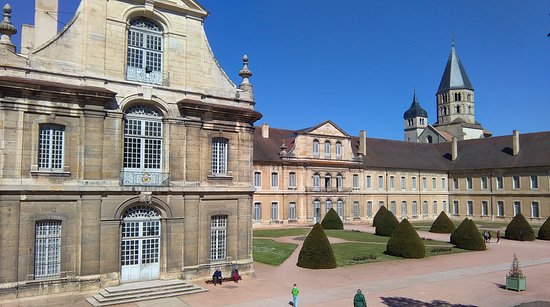
Rue du 11 Août 1944, 71250 Cluny, France Phone: +33 3 85 59 15 93
This photo of Abbey of Cluny is courtesy of TripAdvisor
Cluny Abbey formerly also Cluni, or Clugny is a former Benedictine monastery in Cluny, Saône-et-Loire, France. It was dedicated to St Peter.
The abbey was constructed in the Romanesque architectural style, with three churches built in succession from the 4th to the early 12th centuries. The earliest basilica was the world’s largest church until the St. Peter’s Basilica construction began in Rome.
Cluny was founded by William I, Duke of Aquitaine in 910. He nominated Berno as the first Abbot of Cluny, subject only to Pope Sergius III. The abbey was notable for its stricter adherence to the Rule of St. Benedict, whereby Cluny became acknowledged as the leader of western monasticism. The establishment of the Benedictine Order was a keystone to the stability of European society that was achieved in the 11th century. In 1790 during the French Revolution, the abbey was sacked and mostly destroyed, with only a small part of the Abbey surviving.
Starting around 1334, the Abbots of Cluny maintained a townhouse in Paris known as the Hôtel de Cluny, which has been a public museum since 1843. Apart from the name, it no longer possesses anything originally connected with Cluny.
Source : wikipedia https://www.youtube.com/watch?v=-Deqd47DWb0 https://www.youtube.com/watch?v=mvAJNJiVjjs https://www.youtube.com/watch?v=PgJBEWq5Ues Suggested Duration : 1-2 hours
Synagogue Ln, Jew Town, Kappalandimukku, Mattancherry, Kochi, Kerala 682002
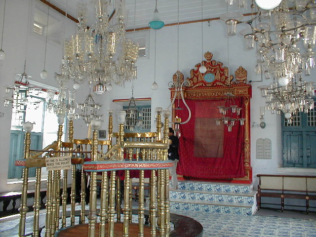
Cochin Jewish Synagogue or the Paradesi Synagogue is the oldest active synagogue in the Commonwealth of Nations, located in Kochi, Kerala, in South India. Constructed in 1567, it is one of seven synagogues of the Malabar Yehudan or Yehudan Mappila people or Cochin Jewish community in the Kingdom of Cochin. Paradesi is a word used in several Indian languages, and the literal meaning of the term is “foreigners”, applied to the synagogue because it was built by Sephardic or Spanish-speaking Jews, some of them from families exiled in Aleppo, Safed and other West Asian localities. It is also referred to as the Mattancherry Synagogue.
The synagogue is located in the quarter of Old Cochin known as Jew Town, and is the only one of the seven synagogues in the area still in use. The complex has four buildings. It was built adjacent to the Mattancherry Palace temple on the land given to the Malabari Yehuden or ” Yehuden Mappila” community by the Raja of Kochi, Rama Varma. The Mattancherry Palace temple and the Mattancherry synagogue share a common wall.
Objects of antiquity
The Paradesi Synagogue has the Scrolls of the Law, several gold crowns received as gifts, many Belgian glass chandeliers, and a brass-railed pulpit. It houses the 10th-century copper plates of privileges given to Joseph Rabban, the earliest known Cochin Jew. These two plates were inscribed in Tamil by the ruler of the Malabar Coast. The floor of the synagogue is composed of hundreds of Chinese, 18th-century, hand-painted porcelain tiles, each of which is unique. A hand-knotted oriental rug was a gift from Haile Selassie, the last Ethiopian emperor.The synagogue has an 18th-century clock tower, which, along with other parts of the complex, was restored between 1998 and 1999 under the direction of the World Monuments Fund.
Emerald Hill is a neighborhood and a conservation area located in the planning areas of Newton and Orchard in Singapore. Former home to many members of the city-state’s wealthy Peranakan community, it is located near Orchard Road. Many of its homes feature Chinese Baroque architecture. Emerald Hill is also the setting for some of the short stories by the late Singaporean author Goh Sin Tub. Many of the homes were designed by Mr. R T Rajoo (Rethinam Thamby Rajoo Pillay) a prominent architect of those days who died in 1928 at his home in Tank Road, Singapore.
Emerald Hill Road was laid out in 1901 and the current terrace houses alongside the road were built between 1901 and 1925.
The Emerald Hill area was originally owned by William Cuppage, a postal clerk who rose to become the acting Postmaster General in the 1840s. Cuppage first leased Emerald Hill in 1837 and in 1845 secured a permanent grant for his nutmeg plantation, which failed in the 1860s because of disease.
Cuppage himself moved from his residence in Hill Street to Emerald Hill in the early 1850s and lived in the area till his death in 1872. Here he built two houses (Erin Lodge and Fern Cottage) where he lived. After his death, Cuppage’s plantation was left to his daughters and in 1890 it was sold to one of his sons-in-law, the lawyer Edwin Koek.
Koek turned the area into an orchard and built another house on the estate, called Claregrove. Koek’s orchard venture failed, however, and he went bankrupt. The property was then sold to Thomas E. Rowell in 1891.
By the turn of the twentieth century, the 13.2 hectare land and its three houses (Erin, Fern and Claregrove) were the property of Seah Boon Kang and Seah Boon Kiat. In 1901, they subdivided the property into 38 plots and these were further subdivided, forming the land area of the terrace houses (Colonial Houses) in Emerald Hill Road.
All three houses were subsequently demolished: Fern Cottage in 1906 made way for terrace houses; in 1924 Claregrove gave way to the Singapore Chinese Girls’ School; Erin Lodge was replaced with more terrace houses.
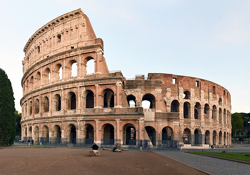
The Colosseum, also known as the Flavian Amphitheatre (Amphitheatrum Flavium in Latin), is an ancient Roman amphitheater located in the center of Rome, Italy. It is one of the most iconic and well-preserved archaeological sites from ancient Rome and is renowned for its historical significance and architectural grandeur. Here are some key facts about the Colosseum:
Historical Significance: The Colosseum was built during the 1st century AD and was inaugurated in 80 AD. It is considered one of the greatest achievements of Roman engineering and architecture.
Purpose: The Colosseum was primarily used for public spectacles, including gladiator contests, chariot races, mock sea battles, animal hunts, and various other forms of entertainment. It could accommodate tens of thousands of spectators.
Design and Architecture: The Colosseum is an elliptical structure with an outer façade characterized by three stories of arches. It stands about 48 meters (157 feet) high and has a perimeter of approximately 527 meters (1,729 feet).
Materials: The core of the Colosseum is constructed of concrete and sand. The exterior façade was faced with travertine limestone and decorated with various statues and inscriptions.
Hypogeum: Below the arena, there was an extensive system of underground passages and chambers known as the hypogeum. This area was used to house animals, gladiators, and equipment, which could be hoisted to the arena through trapdoors.
Seating: The Colosseum could hold an estimated 50,000 to 80,000 spectators, who were seated according to social class. The best seats were reserved for the elite, while the general public sat in the upper tiers.
Imperial Connections: The construction of the Colosseum was initiated by the Roman Emperor Vespasian of the Flavian dynasty and was completed under his son Titus. It was a symbol of the Flavian dynasty’s power and wealth.
Later Use: Over the centuries, the Colosseum was used for various purposes, including as a quarry for building materials and as a fortress during the Middle Ages.
Restoration and Preservation: Efforts have been made to preserve and restore the Colosseum over the years. Today, it is a UNESCO World Heritage Site and a popular tourist destination.
Symbol of Rome: The Colosseum is often seen as a symbol of Rome and its historical grandeur. It is one of the most visited tourist attractions in the world and a testament to the engineering and architectural achievements of ancient Rome.
Plaça Portal de la pau, s/n, 08001 Barcelona, Spain
Phone : +34 932 85 38 32
This photo of Hostal Mare Nostrum is courtesy of TripAdvisor
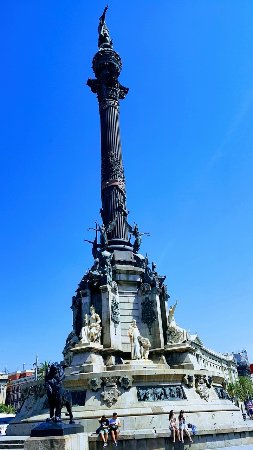
The Columbus Monument is a 60 m (197 ft) tall monument to Christopher Columbus at the lower end of La Rambla, Barcelona, Catalonia, Spain. It was constructed for the Exposición Universal de Barcelona (1888) in honor of Columbus’ first voyage to the Americas. The monument serves as a reminder that Christopher Columbus reported to Queen Isabella I and King Ferdinand V in Barcelona after his first trip to the new continent.
At the very top of the monument stands a 7.2 m (24 ft) tall bronze statue atop a 40 m (131 ft) tall Corinthian column. The statue was sculpted by Rafael Atché and is said to depict Columbus pointing towards the New World with his right hand, while holding a scroll in the left. It is a commonly held belief that instead of pointing to the west towards the New World, the statue points east towards Columbus’s supposed home city of Genoa. This, however, is not true, as the statue points south-southeast (a more southerly direction than the adjacent Rambla Del Mar and almost a perfect extension of the direction of La Rambla, Barcelona) and in effect is pointing at a point somewhere near the city of Constantine, Algeria. To point at Genoa in northern Italy the statue would have to face east-northeast and point up the coastline. It is more likely that the statue is situated in the current way simply to have Columbus point out to sea underscoring his achievements in naval exploration. The statue is atop a socle, on which the word “Tierra” (land) is inscribed.
Source : wikipedia
Ride to the top, and you’ll see! The Columbus Monument which was dedicated in 1888 as part of the ceremonies marking the Universal Exhibition, stands at the end of La Rambla of Barcelona, near the sea. Take the lift inside the column to the viewing gallery at the top, a viewpoint 60 meters above the ground, where you can enjoy great views of Barcelona.
Source : tripadvisor https://www.youtube.com/watch?v=iwVD5f4o09Y https://www.youtube.com/watch?v=1HULyjINPC4 Reviews http://bit.ly/2VQOCeG Opening hours : 08.30 am – 08.30 pm all days of the week Entry : € 6 Above 65 years and Children between 4 – 12 € 4
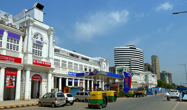
Connaught Place ,(officially Rajiv Chowk) is one of the largest financial, commercial and business centres in New Delhi, India. It is often abbreviated to CP and houses the headquarters of several noted Indian firms. The former location of the headquarters of the British Raj, the area’s environs occupy a place of pride in the city and are counted among the top heritage structures in New Delhi. It was developed as a showpiece of Lutyens with a prominent Central Business District.
Named after H.R.H Field Marshal The 1st Duke of Connaught abd Strathearn, construction work began in 1929 and was completed in 1933. The Inner Circle of Connaught Place was renamed Rajiv Chowk (after Rajiv Gandhi) while the Outer Circle became Indira Chowk under Union Home Minister S.B. Chavan. Today it is the fourth most expensive office destination in the world, according to global property consultant CBRE Group, and the fifth highest priced market in the world according to the 2013 Forbes list.
The area is instantly recognisable on any map of Delhi as a big circle in the middle with radial roads spreading out in all directions. Eight separate roads lead out from Connaught Places’s inner circle, named Parliament Street and Radial Roads 1 through 7. Twelve different roads lead out from Connaught Circus, the outer ring. The best known of these is Janpath, the continuation of Radial Road 1. It is a logically planned area and houses one of India’s first underground markets, the Palika Bazaar (Municipal Market), named after nagarpalika. The Outer Circle is known as the Connaught Circus (officially Indira Chowk),having rows of restaurants, shops and hotels. The Middle Circle has offices, Banks, Exchange houses such as Thomascook, Atwexchange ,PVR cinema and eating outlets.
Connaught Place’s central park has long been a venue for cultural events. In 2005–06, it was rebuilt after the construction of the Delhi Metro station below it. That station, Rajiv Chowk, is the interchange for the Yellow and Blue lines of the Metro and one of the largest and busiest stations in the network. Connaught Place hosts various cultural events in the central park area.
Click On The URL Or PICTURE for the complete News, Videos and more photos.
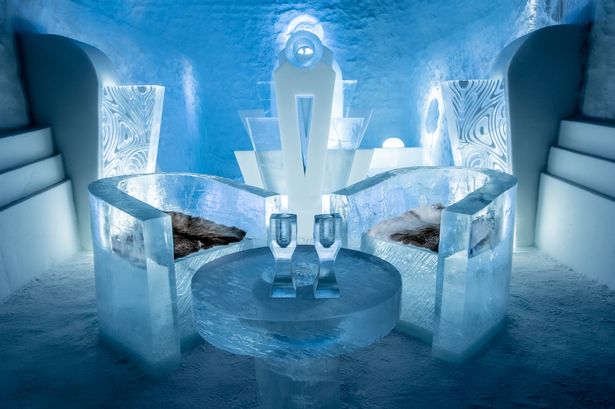
About ICEHOTEL
ICEHOTEL is the world’s first hotel made of ice and snow. Founded in 1989, it is reborn in a new guise every winter, in the Swedish village of Jukkasjärvi – 200 km north of the Arctic Circle. The Torne River, the arts, and creating a setting for life-enriching moments are at the heart of it all.
This winter season there is big news— a whole new ice experience to be enjoyed alongside our classic ICEHOTEL experience. ICEHOTEL 365 is a permanent structure that will include luxury suites, each with sauna and bathroom, and art suites, all sculptured by selected artists. As well as a large ice bar that serves champagne, and an ice gallery. This ice experience can be visited year-round and is cooled by solar panels during the summer months. ICEHOTEL 365 opens mid-November 2016.
The Torne River
With its impressive length of 520 kilometers, it runs from the ancient mountains in the west down to the coast in the east, where it f lows out into the Bay of Bothnia. As the largest of Sweden’s four national rivers it is rare – indeed, unique. One of the last untouched rivers in Europe. A wild river.
It’s the Torne River that provides Icehotel with its ice in winter – and in the summer when the hotel melts, the water returns to its source. Natural ice requires a lot of work – before it is harvested in the very beginning of spring, when it has grown its thickest, months are devoted to maintaining the “ice field” and keeping it clear of snow so that the ice can have the best possible conditions for growth. But in Jukkasjärvi, people think that the natural Arctic ice is worth the effort. “For us the natural beauty and unique story of each individual block of ice provides inspiration that can never be found in artificial ice,” says Petra W Lindh, who has been working at Icehotel for 20 years.
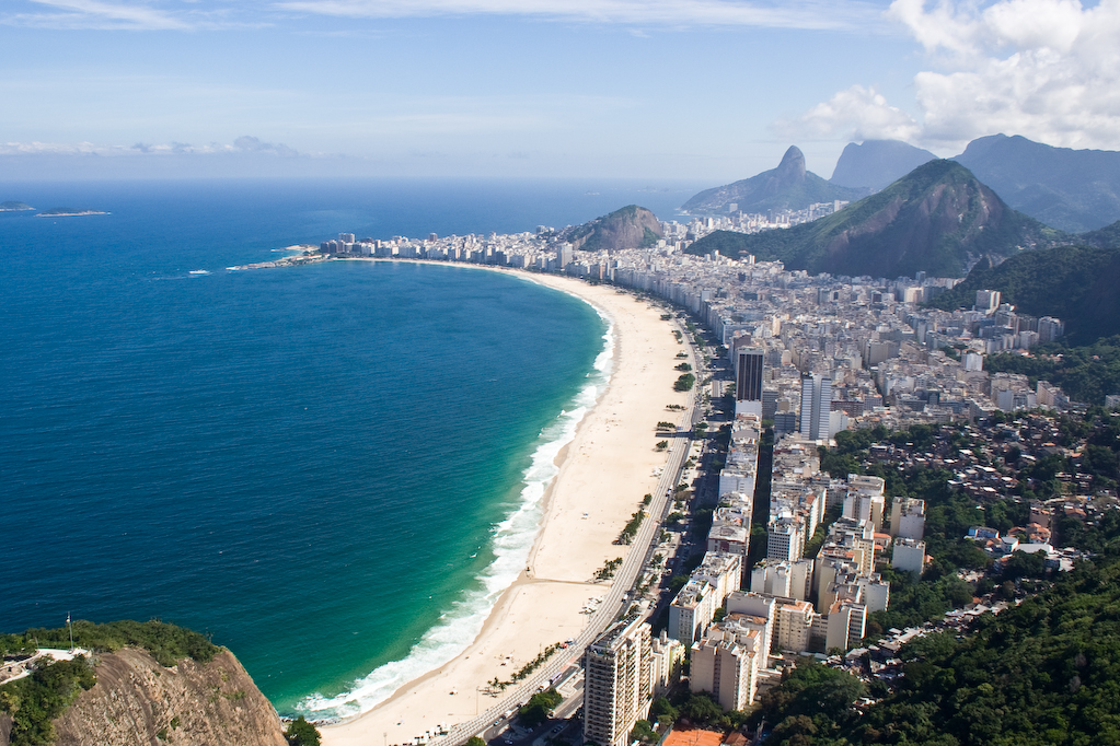
Copacabana located in the South Zone of the city of Rio de Janeiro, Brazil. It is most prominently known for its 4 km (2.5 miles) balneario beach, which is one of the most famous in the world.
Copacabana Beach
Copacabana beach, located at the Atlantic shore, stretches from Posto Dois (lifeguard watchtower Two) to Posto Seis (lifeguard watchtower Six). Leme is at Posto Um (lifeguard watchtower One). There are historic forts at both ends of Copacabana beach; Fort Copacabana, built in 1914, is at the south end by Posto Seis and Fort Duque de Caxias, built in 1779, at the north end. Hotels, restaurants, bars, nightclubs and residential buildings dot the promenade facing Avenida Atlântica. On Sundays and holidays, one side of Avenida Atlântica is closed to cars, giving residents and tourists more space for activities along the beach.
Copacabana Beach plays host to millions of revellers during the annual New Year’s Eve celebrations, and in most years, has been the official venue of the FIFA Beach Soccer World Cup.
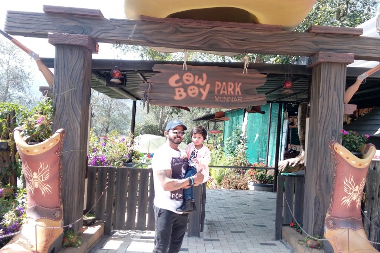
Cowboy Park Munnar is the greatest fun ever-happened to Munnar! , Away from its crowd – it’s adventures galore!
Munnar… The green capital of India, where the winds smell pekoe and mountains flourish tea plantations. It is one of the best picturesque hill stations in India to rejuvenate your soul. Munnar hill station, located 1600m above the sea level was a summer resort from the erstwhile British Government in South India. Madupetty (Mattupetty) also known as Switzerland of Kerala, a small village nearby Munnar famous for storage Concrete Gravity dam, Kundala Lake and Highly specialized dairy farm, the Indo-Swiss live stock project. Madupetty is the best place for Water sports activities like Speed launch, slow speedboat, and motorboats speed boating
The Cowboy Park, the joint venture of Fun factory Group and Kerala State Hydel Tourism by State Electricity Board. Located on the banks of Madupetty dam is another reason to be in Munnar. In the Midst of sun moon valley of the Madupetty Boat landing offers you breathtaking adventure and fun.
It’s not a Place to kill Time – But is a Place to have a Great Time!
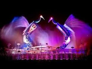
Watch the magical love story between a pair of mechanical cranes and how their love for each other transforms into real birds.Combining groundbreaking audio and visual technologies, astounding light and water effects, be awed by the cranes’ graceful courtship ritual. The sheer size of the steel cranes moving deftly in the midst of water illusion and play of light is one not to be missed.
Catch the cranes before they fly away, every evening at the WaterFront.
Source : sentosa.com.sg
We take you through a magical journey of love, with the touching story of a pair of mechanical cranes and how their love for each other transforms them into real birds.
A show that’s not to be missed, the combination of groundbreaking audio visual technologies, and stunning light and water effects perfectly illustrates the cranes’ graceful courtship ritual. We are in awe of the sheer size of the steel cranes moving deftly in the midst of water illusion and play of light.
Catch the cranes before they fly away!
*Pyrotechnics will be used in the shows.
Source : rwsentosa.com
Getting There
By Sentosa Express: Alight at WaterFront Station
By Bus:
– Sentosa Bus 1 or Bus 2 and alight at Resorts World Sentosa (Basement 1)
– RWS 8 and alight at RWS 8 bus stop outside The Forum, Sentosa
By Foot: Take a stroll down the Sentosa Boardwalk to Resorts World Sentosa
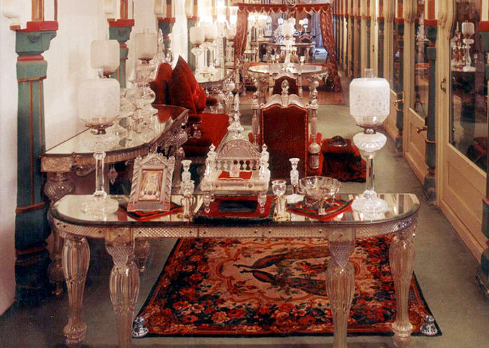
The beautiful Crystal Gallery is certainly one of its kind with innumerable rare and unique crystals on display. Established by Maharana Sajjan Singhji, the gallery is almost 129 years old. It was opened for the general public only around 1994 before which the crystals were said to be underground.
The gallery is said to be the world’s single largest private collection of crystals at one place. The location of the collection is on the first floor of the elegant Durbar Hall Sabhagaar or Minto Hall (Named after the Indian Viceroy).
It was in the year 1877 the Maharana Sajjan Singh (1874 – 1884) ordered the crystal collection from Birmingham based F&C Osler glass cutters company. He died before the crystal chairs, beds, sofas, glasses, dinner sets and flywhisks arrived in Udaipur. Successors thought this was a bad omen and the extraordinary bequest stayed packed in boxes for 110 years. The admission fee to the crystal gallery includes the entry charges to the grand Durbar Hall of the Fateh Prakash Palace and a drink in the Gallery Restaurant.
The exquisite crystal items in the gallery range from dining table, table, sofa set, washing bowl, goblet, tray, decanter, to perfume bottles, candle stands, crockery and even beds. The highlight of the gallery is a jewel studded carpet, embodying peerless class.
The gallery even exhibits a Royal punkah (manually operated fan) in crystal and soft red satin material with the Mewar emblem of the Sun embroidered on it.
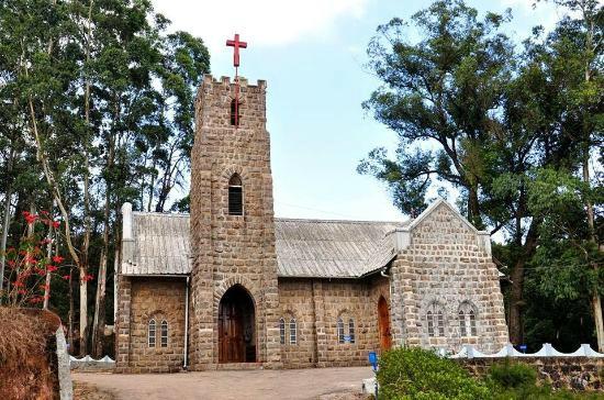
The old CSI Christ Church Munnar is the headquarters of the CSI Munnar Pastorate with over thousand Tamil families and 18 outstation churches. The church, counted amongst the most revered sites in Munnar, was built in AD 1910 by the British. This holy site is popular for its exquisite stained glass windows. Besides, it has engraved brass plaques that were made in the memory of the tea planters.
The site of the church was formally consecrated by Rt. Rev. Noel Hodges on 15th April 1900 on the occasion of Easter. The church’s foundation stone was laid in March 1910 by Sir A.K. Muir and inaugurated on 16th April 1911 by Rev. W.F.B Hoysted, the then priest. When the British left Munnar in 1981, they handed over the charge of the church to CSI North Kerala Diocese.
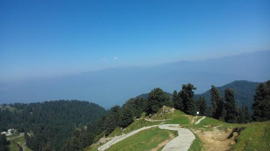
With its beautiful snow covered peaks and lush green surroundings Dainkund peak, located 10kms. from Dalhousie at an elevation of 2755 meters attract tourists from all over the globe. Dainkund is the highest peak in Dalhousie and gets maximum snowfall during the winter season. Beautiful Deodar trees, calm forests, colorful flowers, and green valleys are the main reasons that attracts tourists to this place. This is a paradise for photographers. There are a few villages nearby Dainkund that offers scenic charm and picturesque view of the mud houses in the village. The noise of the breeze passing through the trees makes a musical sound here and so Dainkund is popularly known as the singing hill.Trekking is the most common activity in this area. Pholani Devi Temple, where there is nothing except only a trident, is situated here. Lots of people visit the temple. The best time to visit this wonderful destination is in winter, when the hill is loaded with lush green trees, refreshing flowers and snow.
The town of McLeod Ganj in Upper Dharamsala is known worldwide as His Holiness the Dalai Lama resides here and is also known as Little Lhasa of Tibet. The Dalai Lama temple is where His Holiness the Dalai Lama gives teachings several times a year. His Holiness’ residence is located near the main temple and the headquarters of the Tibetan Government in Exile is located just below McLeod Ganj.The Tibetans settled in Dharamshala in 1960, as His Holiness the Dalai Lama had to flee Tibet in 1959 and the Prime Minister of India allowed Him and some of His followers to settle in McLeod Ganj, a colonial British summer picnic spot. is the most sacred monument in McLeod Ganj.The temple houses larger than life statues of the Buddha, Padmasambhava and Avaloktwshwara. The temple also houses one of the largest collections of sacred Tibetan texts. You can meditate or You can take a serene morning or evening walk around the temple.It is 10 minutes walk from the guess house.
Source : mygola.com
The Dalai Lama temple is located at upper Dharamsala, just a short distance from McLeodGanj town. It is a friendly and good place to spend some time. During the morning hours visitors can participate in the prayers as the monks chant and meditate. The Residence of Dalai Lama is next to the temple – there is a nice path that goes around the temple and the place where the Dalai Lama lives. It has some prayer wheels, prayer flags and mani stones. This walk should be done clockwise.
Click On The Headlines Or Image for the complete News, Videos and more photos.
There’s a level of accommodation and way of communicating that’s an art. This specific language of luxury is spoken fluently at Market Square Tower. From the sleek silhouette of the architecture to the spacious and fully appointed residences, Market Square Tower is an exceptional downtown experience. It’s the gold standard for extraordinary living. The taste level is smarter, more intuitive, and expressive.
Your lifestyle will be celebrated, honored and nourished with concierge services and abundant amenities. Thrive in a cosmopolitan atmosphere that takes inspiration from the arts, ballet, theatre, and creativity. Have immediate access to the very best of Houston’s delights and professional opportunities. The world will literally be at your feet.
Source : marketsquaretower.com
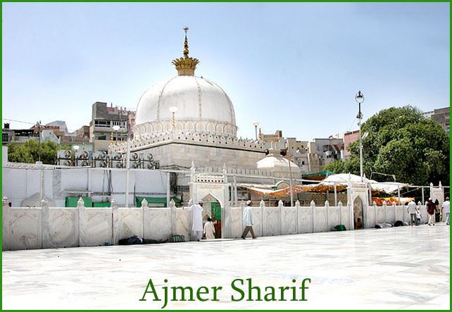
123, Faiz Manzil, Imam Bada, Khadim Mohalla, Ajmer, Rajasthan 305001
Dargah Sharif is situated 135 kms. From Jaipur.
Image Credit :pinterest.comImage Credit : wikipedia
Dargah Sharif or Ajmer Sharif is a Sufi shrine of sufi saint, Moinuddin chishti (1141-1236) located at Ajmer, Rajasthan, India. The shrine has the grave (Maqbara) of the revered saint, Moinuddin Chisti.
Moinuddin Chishti also known as Gharīb Nawāz (Benefactor of the Poor), was an Imam, Islamic scholar and philosopher from South Asia.. Chishti introduced and established the Chishti Order of Sufism in the Indian subcontinent. The initial spiritual chain or silsila of the Chishti order in India, comprising Chishti,Qutbuddin Bakhtiar kaki, Fariduddin Ganjshakar and Nizamuddin Auliya, and —each successive person being the disciple of the previous—includes the great Sufi saints of Indian history. Various Mughal emperors were followers of Chisti.
The most important of all Muslim pilgrimage centers in India, the dargah of Moinuddin Chishti at Ajmer Sharif is revered by people of all faiths and is renowned for fulfilling the wishes of the followers. Apart from the devout Muslims, people of other religions throng the holy dargah and pray for the fulfillment of their desires.
The main gate to the shrine is the Nizam Gate, followed by the Shahjahani Gate, erected by the Mughal emperor Shah Jahan. In turn it is followed by the Buland Darwaza, built by Sultan Mahmood Khilji, upon which is hoisted the urs flag, marking the beginning of the death anniversary rituals. The urs for Moinuddin Chishti is celebrated every year on the 6th and 7th of Rajab.
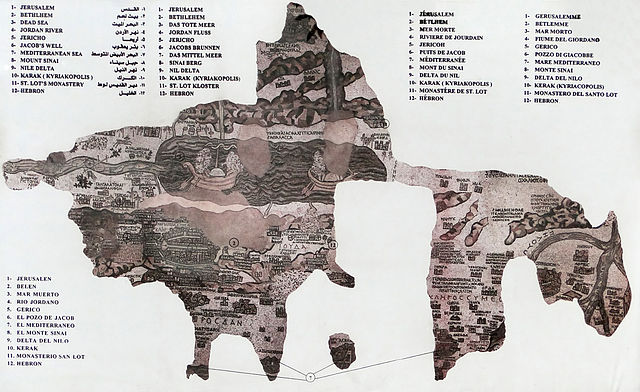
Madaba Map ( Greek Orthodox church ) │ Byzantine Church
Greek Orthodx Church
The Madaba Map (also known as the Madaba Mosaic Map) is part of a floor mosaic in the early Byzantine church of Saint George at Madaba, Jordan. The Madaba Map is a map of the Middle East. Part of it contains the oldest surviving original cartographic depiction of the Holy Land and especially Jerusalem. It dates to the 6th century AD.
History
Reproduction of the Madaba Map
The Madaba Mosaic Map depicts Jerusalem with the Nea Church, which was dedicated on the 20th of November, AD 542. Buildings erected in Jerusalem after 570 are absent from the depiction, thus limiting the date range of its creation to the period between 542 and 570. The mosaic was made by unknown artists, probably for the Christian community of Madaba, which was the seat of a bishop at that time. In 614, Madaba was conquered by the Persian empire. In the 8th century AD, the Muslim Umayyad rulers had some figural motifs removed from the mosaic. In 746, Madaba was largely destroyed by an earthquake and subsequently abandoned. The mosaic was rediscovered in 1884, during the construction of a new Greek Orthodox church on the site of its ancient predecessor.[1] In the following decades, large portions of the mosaic map were damaged by fires, activities in the new church and by the effects of moisture. In December 1964, the Volkswagen Foundation gave the Deutscher Verein für die Erforschung Palästinas (“German Society for the exploration of Palestine”) 90,000 DM to save the mosaic. In 1965, the archaeologists Heinz Cüppers and Herbert Donner undertook the restoration and conservation of the remaining parts of the mosaic.
Description
The floor mosaic is located in the apse of the church of Saint George at Madaba. It is not oriented northwards, like modern maps, but faces east towards the altar in such a fashion that the position of places on the map coincides with the actual compass directions. Originally, it measured 21 by 7 m and contained over two million tesserae. Its current dimensions are 16 by 5 m.
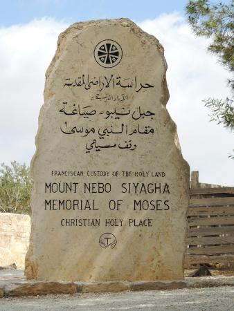
Image credit : tripadvisorThe Serpentine Cross (The Brazen Serpent Monument). This is a symbolic of the Bronze serpent taken by Moses (pbuh) into the desert, and the cross upon which Jesus (pbuh) was crucifiedOn March 19, 2000, Pope John Paul II visited Mt.Nebo during his pilgrimage to the Holy Land, planting an olive tree next to the Byzantine chapel for peace
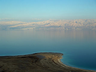
Mount Nebo is an elevated ridge in Jordan, approximately 817 metres (2,680 ft) above sea level, mentioned in the Hebrew Bible as the place where Moses was granted a view of the Promised Land. The view from the summit provides a panorama of the Holy Land and, to the north, a more limited one of the valley of the River Jordan. The West Bank city of Jericho is usually visible from the summit, as is Jerusalem on a very clear day.
Religious significance
According to the final chapter of the Book of Deuteronomy, Moses ascended Mount Nebo to view the Land of Israel, which God had said he would not enter, and to die there; he was buried in an unknown valley location in Moab.
According to Christian tradition, Moses was buried on the mountain, although his place of burial is not specified.(Deuteronomy 34:6) Some Islamic traditions also stated the same, although there is a grave of Moses located at Maqam El-Nabi Musa, 11 km (6.8 mi) south of Jericho and 20 km (12 mi) east of Jerusalem in the Judean wilderness. Scholars continue to dispute whether the mountain currently known as Nebo is the same as the mountain referred to in Deuteronomy.
According to 2 Maccabees, (2:4–7), the prophet Jeremiah hid the tabernacle and the Ark of the Covenant in a cave there.
On March 19, 2000, Pope John Paul II visited the site during his pilgrimage to the Holy Land. During his visit he planted an olive tree beside the Byzantine chapel as a symbol of peace. Pope Benedict XVI visited the site in 2009, gave a speech, and looked out from the top of the mountain in the direction of Jerusalem.
A serpentine cross sculpture (the Brazen Serpent Monument) atop Mount Nebo was created by Italian artist Giovanni Fantoni. It is symbolic of the bronze serpent created by Moses in the wilderness (Numbers 21:4–9) and the cross upon which Jesus was crucified (John 3:14).
Archaeology
On the highest point of the mountain, Syagha, the remains of a Byzantine church and monastery were discovered in 1933.[8] The church was first constructed in the second half of the 4th century to commemorate the place of Moses’ death. The church design follows a typical basilica pattern. It was enlarged in the late fifth century A.D. and rebuilt in A.D. 597. The church is first mentioned in an account of a pilgrimage made by a lady Aetheria in A.D. 394. Six tombs have been found hollowed from the natural rock beneath the mosaic-covered floor of the church. In the modern chapel presbytery, built to protect the site and provide worship space, remnants of mosaic floors from different periods can be seen. The earliest of these is a panel with a braided cross presently placed on the east end of the south wall.
The Moses Memorial that houses the Byzantine mosaics has been closed for renovation from 2007 to 2016. It reopened on 15 October 2016.
Church of AnnunciationCatholic Mass in the Grotto of the Annunciation (lower level of the church).
The Church of the Annunciation, sometimes also referred to as the Basilica of the Annunciation is a church in Nazareth, in northern Israel.
History
The church was established at the site where, according to Roman Catholic tradition, the Annunciation took place. Greek Orthodox tradition holds that this event occurred while Mary was drawing water from a local spring in Nazareth, and the Greek Orthodox Church of the Annunciation was erected at that alternate site.
The current church is a two-story building constructed in 1969 over the site of an earlier Byzantine-era and then Crusader-era church. Inside, the lower level contains the Grotto of the Annunciation, believed by many Christians to be the remains of the original childhood home of Mary. Under Roman Catholic canon law, the church enjoys the status of a minor basilica. A historically significant site, considered sacred within some circles of Christianity, particularly Catholicism, the basilica attracts many Catholic, Anglican, and Eastern Orthodox Christian visitors every year.
The first shrine was probably built sometime in the middle of the 4th century, comprising an altar in the cave in which Mary had lived. A larger structure was commissioned by Emperor Constantine I, who had directed his mother, Saint Helena, to found churches commemorating important events in Jesus Christ’s life. The Church of the Annunciation was founded around the same time as the Church of the Nativity (the birthplace) and the Church of the Holy Sepulchre (the tomb). Some version of it was known to have still been in existence around 570 AD, but it was destroyed in the 7th century after the Muslim conquest of Palestine.
The second church was built over the ruins of the Byzantine era church during the Crusades, following the conquest of Nazareth by Tancred in 1102. The Crusader era church was never fully completed. Five Romanesque capitals carved by artists from northern France, and discovered during excavations in 1909, had not yet been installed in 1187 when news of Saladin’s victory in the Battle of Hittin reached the city. Saladin granted permission to Franciscan priests to remain in Nazareth to oversee services at the church.
In 1260, Baybars and his Mamluk army destroyed the church during their attack on Nazareth. A small number of Franciscans managed to stay in Nazareth until the fall of Acre in 1291. In the three centuries that followed, the Franciscans were in and out of Nazareth, depending on the local political situation, which was constantly in flux. Franciscan accounts of this period document their expulsion in 1363, their return in 1468 and a massacre of some of their members in 1542. Local Christian families with Franciscan support helped take care of the church as well during this period.
Emir Fakr ad-Din granted the Franciscans permission to return in 1620, at which time they constructed a small structure to enclose the holy grotto that is venerated as the house of Mary. In 1730, Zahir al-Umar permitted construction of a new church, which became a central gathering place for Nazareth Latin community. The church was enlarged in 1877, and then completely demolished in 1954 to allow for the construction of a new basilica, which was completed in 1969. The new basilica was designed by the Italian architect Giovanni Muzio, and built by the Israeli building firm Solel Boneh during the years 1960-69. Used by the Latin parish, it remains under the control of the Franciscans. It is the largest Christian sanctuary in the Middle East, and was dedicated in 1964 by Pope Paul VI.
In this Basilica is a gallery with mosaics representing some of the most important Marian devotions in different countries. Among the Marian devotions in Spain include: The Virgin of Candelaria, patron saint of the Canary Islands, the Virgin of Montserrat, patroness of Catalonia, the Virgin of the Forsaken, patroness of Valencia and the Virgin of Guadalupe, patroness of Extremadura.
St. Joseph’s Church is a Franciscan Roman Catholic church in the Old City of Nazareth, modern-day Northern Israel. It was built in 1914 over the remains of much older churches. It is located close to the Church of the Annunciation. It was built in the Romanesque Revival style.
Source : wikipedia
Cana of Galilee. Holy land photographed by Daniel B. Shepp. 1894The “Wedding church”
The Gospel of John refers a number of times to a town called Cana of Galilee.
Biblical references
Among Christians and other students of the New Testament, Cana is best known as the place where, according to the Fourth Gospel, Jesus performed “the first of his signs”, his first public miracle, the turning of a large quantity of water into wine at a wedding feast (John 2:1–11) when the wine provided by the bridegroom had run out. Although none of the synoptic gospels record the event, mainstream Christian tradition holds that this is the first public miracle of Jesus.
John 2:1-11 states that while Jesus was at a wedding in Cana with his disciples, the party ran out of wine. Jesus’ mother (unnamed in John’s Gospel) told Jesus, “They have no wine,” and Jesus replied, “O Woman, what has this to do with me? My hour has not yet come.” His mother then said to the servants, “Do whatever he tells you” (John 2:3-5). Jesus ordered the servants to fill containers with water and to draw out some and take it to the chief steward waiter. After tasting it, without knowing where it came from, the steward remarked to the bridegroom that he had departed from the custom of serving the best wine first by serving it last (John 2:6-10). John adds that: “Jesus did this, the first of his signs, in Cana of Galilee, and it revealed his glory; and his disciples believed in him” (John 2:11).
Mount Tabor is located in Lower Galilee, Israel, at the eastern end of the Jezreel Valley, 11 miles (18 km) west of the Sea of Galilee. It is believed by many Christians to be the site of the Transfiguration of Jesus. It is known as Har Tavor in Hebrew, Itabyrium in the Graeco-Roman world, Jebel et-Tur in Arabic, and the Mount of Transfiguration in Christian context.
Mount Tabor is shaped almost like a half-sphere, suddenly rising from rather flat surroundings and reaching a height of 575 metres (1,886 feet), thus dominating by a good 450 metres the next town in the plain below, Kfar Tavor. The Catholic church at the top is well visible from afar. At the base it is almost fully surrounded by the Arab villages of Daburiyya, Shibli, and Umm al-Ghanam.
Mount Tabor is located off Highway 65, and its summit is accessible by personal vehicle via Shibli. A shuttle service with minibuses transports those tourists which arrive in large coaches, such being too large for the narrow serpentines leading up to the top.
Nowadays reaching the top of the mountain itself does not demand great effort, but some 1,600 years ago one had to walk up no less than 4,340 stairs in order to arrive at the peak of the mountain.
The Church of the Transfiguration is a Franciscan church located on Mount Tabor in Israel. It is traditionally believed to be the site where the Transfiguration of Christ took place, an event in the Gospels in which Jesus is transfigured upon an unnamed mountain and speaks with Moses and Elijah.
The church contains three grottoes belonging to the Crusader church. They were described by Jonas Korte, a publisher from Eldena, as “three chapels, with a small altar. They are called tabernacles, and they are said to represent the three huts which Peter desired to build, one for his Master (Jesus) the other two for Moses and Elias (Elijah)”.
The Grotto of Christ is in the eastern part of the church. Steps lead down to a lower level containing a sanctuary roofed with a modern vault.
There is a chapel in each of the two towers at the western end of the church. The Chapel of Elijah is located in the south tower; the north tower holds the Chapel of Moses.
In the upper part of the church there is a mosaic on a gold ground representing the Transfiguration. On Aug 6th, which is the “day of the Transfiguration” in some church calendars, the sun strikes a glass plate set into the floor so that the golden mosaic is briefly illuminated.
The Transfiguration of Jesus is an event reported by the Synoptic Gospels in which Jesus is transfigured upon a mountain (Matthew 17:1–9, Mark 9:2–8, Luke 9:28–36). Jesus becomes radiant, speaks with Moses and Elijah, and is called “Son” by God. The transfiguration put Jesus above Moses and Elijah, the two preeminent figures of Judaism.
Capernaum was a fishing village established during the time of the Hasmoneans, located on the northern shore of the Sea of Galilee. It had a population of about 1,500. Archaeological excavations have revealed two ancient synagogues built one over the other. A house turned into a church by the Byzantines is said to be the home of Saint Peter.
New Testament
The town is cited in all four gospels (Matthew 4:13, 8:5, 11:23, 17:24, Mark 1:21, 2:1, 9:33, Luke 4:23, 31,7:1, 10:15, John 2:12, 4:46, 6:17, 24,59) where it was reported to have been near the hometown of the apostles Simon Peter, Andrew, James and John, as well as the tax collector Matthew. One Sabbath, Jesus taught in the synagogue in Capernaum and healed a man who was possessed by an unclean spirit (Luke 4:31–36 and Mark 1:21–28). This story is notable for being the only one common between the gospels of Mark and Luke, but not contained in the gospel of Matthew (see Synoptic Gospels for more literary comparison between the gospels). Afterwards, he healed Simon Peter’s mother-in-law of a fever (Luke 4:38-39). According to Luke 7:1–10 and Matthew 8:5, it is also the place where Jesus healed the servant of a Roman centurion who had asked for his help. Capernaum is also the location of the healing of the paralytic lowered through the roof to reach Jesus reported in Mark 2:1–12, and Luke 5:17–26.
In Matthew 9:1 the town is referred to only as “his own city” and the narrative does not mention the paralytic being lowered through the roof. Most traditional biblical commentators assume that “his own city” means Capernaum because of the details which are common to the three synoptic gospels. although the writers of the Jamieson-Fausset-Brown Bible Commentary suggest that alternatively it could refer to Nazareth.
According to the Synoptic Gospels, Jesus selected this town as the center of his public ministry in Galilee after he left the small mountainous hamlet of Nazareth (Matthew 4:12–17). He also formally cursed the city, saying “you will be thrown down to Hades!” (Matthew 11:23) because of their lack of faith in him as the Messiah.
House of Peter
One block of homes, called by the Franciscan excavators the sacra insula or “holy insula” (“insula” refers to a block of homes around a courtyard) was found to have a complex history. Located between the synagogue and the lake shore, it was found near the front of a labyrinth of houses from many different periods. Three principal layers have been identified:
A group of private houses built around the 1st century BC which remained in use until the early 4th century.
The great transformation of one of the homes in the 4th century.
The octagonal church in the middle of the 5th century.
The excavators concluded that one house in the village was venerated as the house of Peter the fisherman as early as the mid-1st century, with two churches having been constructed over it (Loffreda, 1984).
Synagogue
The ruins of this building, among the oldest synagogues in the world, were identified by Charles William Wilson. The large, ornately carved, white building stones of the synagogue stood out prominently among the smaller, plain blocks of local black basalt used for the town’s other buildings, almost all residential. The synagogue was built almost entirely of white blocks of calcareous stone brought from distant quarries.
The building consists of four parts: the praying hall, the western patio, a southern balustrade and a small room at the northwest of the building. The praying hall measured 24.40 m by 18.65 m, with the southern face looking toward Jerusalem.
The internal walls were covered with painted plaster and fine stucco work found during the excavations. Watzinger, like Orfali, believed that there had been an upper floor reserved for women, with access by means of an external staircase located in the small room. But this opinion was not substantiated by the later excavations of the site.
The synagogue appears to have been built around the 4th or 5th century. Beneath the foundation of this synagogue lies another foundation made of basalt, and Loffreda suggests that this is the foundation of a synagogue from the 1st century, perhaps the one mentioned in the Gospels (Loffreda, 1974). Later excavation work was attempted underneath the synagogue floor, but while Loffreda claimed to have found a paved surface, others are of the opinion that this was an open, paved market area.
The ancient synagogue has two inscriptions, one in Greek and the other in Aramaic, that commemorates the benefactors that helped in the construction of the building. There are also carvings of five- and six-pointed stars and of palm trees.
The Church of the Multiplication of the Loaves and Fish, shortened to (The Church of the Multiplication), is a Roman Catholic church located at Tabgha, on the northwest shore of the Sea of Galilee in Israel. The modern church rests on the site of two earlier churches.
The earliest recording of a church commemorating Jesus’ feeding of the five thousand is by the Spanish pilgrim Egeria circa AD 380.
“Not far away from there (Capernaum) are some stone steps where the Lord stood. And in the same place by the sea is a grassy field with plenty of hay and many palm trees. By them are seven springs, each flowing strongly. And this is the field where the Lord fed the people with the five loaves and two fishes. In fact the stone on which the Lord placed the bread has now been made into an altar. Past the walls of this church goes the public highway on which the Apostle Matthew had his place of custom. Near there on a mountain is a cave to which the Savior climbed and spoke the Beatitudes.”
The Church of the Beatitudes is a Roman Catholic church located by the Sea of Galilee near Tabgha and Capernaum in Israel.
Located on a small hill overlooking the Sea of Galilee, and built on the traditional site of Jesus delivery of the Sermon on the Mount, pilgrims are known to have commemorated this site since at least the 4th century. In her itinerary of the Holy Land, after describing the Church of the Loaves and Fishes, the pilgrim Egeria (ca. 381 CE) writes, “Near there on a mountain is the cave to which the Savior climbed and spoke the Beatitudes.” The current church sits near the ruins of a small Byzantine era church dating to the late 4th century, which contains a rock-cut cistern beneath it and the remains of a small monastery to its southeast. Part of the original mosaic floor has also been recovered and is now on display in Capernaum. Both Popes Paul VI and John Paul II celebrated Mass at the church during their pastoral visits to the Holy Land.
The modern church was built between 1936 and 1938 near the site of the fourth-century Byzantine ruins. The floor plan is octagonal, the eight sides representing the eight Beatitudes.[2] The church is Neo-Byzantine in style with a marble veneer casing the lower interior walls and gold mosaic in the dome. Around the altar are mosaic symbols on the pavement representing Justice, Prudence, Fortitude, Temperance, Faith, Hope, and Charity.
Jerome Murphy-O’Connor describes the selection of the site thus: “It was perhaps inevitable that this well-watered area with its shade trees on the shore of the Sea of Galilee, where Byzantine pilgrims ate their picnics, should have been identified as the location of two episodes involving the consumption of food, the multiplication of the loaves and fishes and the conferral on Peter of the responsibility of leadership after a fish breakfast. Then it became convenient to localize the Sermon of the Mount on the small hill nearby.” (The Holy Land: An Oxford Archaeological Guide from Earliest Times to 1700, p. 277) Regardless of whether this is the very spot, the Church of the Beatitudes stands in the general area and in a very similar setting to where Jesus would have stood as he delivered his famous sermon. As Murphy-O’Connor puts it, “from here one can see virtually all the places in which Jesus lived and worked” (p. 280).
The boat on display in its special climatised museum hal
The Ancient Galilee Boat, also known as the Jesus Boat, was an ancient fishing boat from the 1st century AD, discovered in 1986 on the north-west shore of the Sea of Galilee in Israel. The remains of the boat, 27 feet (8.27 meters) long, 7.5 feet (2.3 meters) wide and with a maximum preserved height of 4.3 feet (1.3 meters), first appeared during a drought, when the waters of the Sea (actually a great fresh-water lake) receded. There is no evidence connecting the boat to Jesus or his disciples.
The remains of the Ancient Galilee Boat were found by brothers Moshe and Yuval Lufan, fishermen from Kibbutz Ginnosar. The brothers were keen amateur archaeologists with an interest in discovering artifacts from Israel’s past. It had always been their hope to one day discover a boat in the Sea of Galilee, where they and generations of their family had fished. When drought reduced the water-level of the lake, the two brothers examined the newly exposed beach and stumbled across the remains of the boat buried in the shore.
The brothers reported their discovery to the authorities who sent out a team of archaeologists to investigate. Realising that the remains of the boat were of tremendous historical importance to Jews and Christians alike, an archaeological dig followed, undertaken by members of Kibbutz Ginosar, the Israel Antiquities Authority, and numerous volunteers. Rumour spread that the boat was full of gold and the dig had to be guarded night and day. Excavating the boat from the mud without damaging it, quickly enough to extract it before the water rose again, was a difficult process which lasted 12 days and nights. The ancient wood was extremely fragile when exposed to the atmosphere and the boat had to be rescued from the place it was found by wrapping it in a mantle of fiberglass and insulating foam, which helped with both keeping it together, and floating it to its new location. It was then submerged in a chemical bath for 10 years before it could be displayed at the Yigal Allon Galilee Boat Museum in Kibbutz Ginosar.
The Galilee Boat is historically important to Jews as an example of the type of boat used by their ancestors in the 1st century for both fishing and transportation across the lake. Previously only references made by Roman authors, the Bible and mosaics had provided archeologists insight into the construction of these types of vessels.The boat is also important to Christians because this was the sort of boat used by Jesus and his disciples, several of whom were fishermen.|date=29 February 1980 |accessdate=29 January 2013}}</ref> Boats such as this played a large role in Jesus’ life and ministry, and are mentioned 50 times in the Gospels, though there is no evidence connecting the Sea of Galilee Boat itself to Jesus or his disciples.
The St.Peter’s home (Church) also called the Pilgrimage Church of St. Peter in Capernaum is a modern Catholic pilgrimage church found in the archaeological site of Capernaum, northern Israel. The church is part of the Franciscan monastery in Capernaum. It is dedicated to St. Peters, which Catholics consider the first leader of the Church.
Archaeological excavations carried out in this place, discovered another layer of residential structures, on which the first half of a first century church was built. It is considered “the first church in the world” and believes it could be the place where the house of the Apostle Peter was. In the V century, in place an octagonal church was built. In 1990, with the remains of these ancient temples it was built a church of modern pilgrimage.
The Pilgrimage Church of St. Peter is located in the central part of the archaeological site of Capernaum, at an altitude of 195 meters p.p.m. on the west coast north of the Sea of Galilee, in the depression of the Jordan Valley, in northern Israel.
The Church of the Primacy of St.Peter is a Franciscan church located in Tabgha, Israel, on the northwest shore of the Sea of Galilee. It commemorates, and allegedly marks the spot, of Jesus’ reinstatement of Peter as chief among the Apostles.
The modern structure was built in 1933 and incorporates parts of an earlier 4th century church. At the base of its walls, opposite the main altar, foundations of the 4th century church are visible. In the 9th century, the church was referred to as the Place of the Coals. This name refers to the incident of Jesus’ preparation of meal for the apostles, building a charcoal fire on which to cook the fish. Also first mentioned in the year 808 are the “Twelve Thrones”, a series of heart shaped stones, which were placed along the shore to commemorate the Twelve Apostles. The church survived longer than any other in the area, finally being destroyed in 1263.[1] The present Franciscan chapel was built on the site in 1933. This church was included in the itineraries of Popes Paul VI and John Paul II during their visits to Israel in 1964 and March 2000 respectively.
The church contains a projection of limestone rock in front of the present altar which is venerated as a “Mensa Christi”, Latin for table of Christ. According to tradition this is the spot where Jesus is said to have laid out a breakfast of bread and fish for the Apostles, and told Peter to “Feed my sheep” after the miraculous catch, the third time he appeared to them after his resurrection. (John 21:1-24) It is disputed whether this table, or the one enshrined at the nearby Church of the Multiplication, is the one mentioned by the pilgrim Egeria in her narrative of the Holy Land circa 380. There is also another table of Christ enshrined at the Mensa Christi Church in Nazareth.
Yardenit (Hebrew: ירדנית), also known as the Yardenit Baptismal Site, is a baptism site located along the Jordan River in the Galilee region of northern Israel, which is frequented by Christian pilgrims. The site is located south of the river’s outlet from the Sea of Galilee, near Kibbutz Kvutzat Kinneret, which owns and manages the site. History
According to Christian tradition, the baptism of Jesus (Matthew, 3: 13-17) took place in Qasr el Yahud, north of the Dead Sea and east of Jericho. For centuries, Qasr el Yahud was the most important baptism site for pilgrims, and monasteries and guest houses were established near it. Al-Maghtas in Jordan shows the earliest religious structures connected with baptism or religious baths on the Eastern part of the Jordan, but reverence shifted to the West bank after the Muslim Conquest.
After the Six-Day War Qasr el Yahud fell under Israeli occupation. Due to military activity and excavations, the Israeli Ministry of Tourism established Yardenit in 1981 as an alternative pilgrimage site. Yardenit became the first regulated baptism site on the Israeli side of the river. Qasr el Yahud reopened in 2011. In 2015, the Unesco declared Al Maghtas together with Jabal Mar-Elias (Elijah’s Hill) on the East bank a world heritage site.
The Yardenit Baptismal Site currently averages 400,000 visitors a year and attracts members of all faiths.
Source : wikipedia
Haifa is the third-largest city in the State of Israel, with a population of 278,903 in 2015. The city forms part of the Haifa metropolitan area, the second- or third-most populous metropolitan area in Israel. It is also home to the Bahá’í World Centre, a UNESCO World Heritage Site and a destination for Baha’i pilgrims.
Built on the slopes of Mount Carmel, the settlement has a history spanning more than 3,000 years. The earliest known settlement in the vicinity was Tell Abu Hawam, a small port city established in the Late Bronze Age (14th century BCE). In the 3rd century CE, Haifa was known as a dye-making center. Over the centuries, the city has changed hands: being conquered and ruled by the Phoenicians, Persians, Hasmoneans, Romans, Byzantines, Arabs, Crusaders, Ottomans, British, and the Israelis. Since the establishment of the State of Israel in 1948, the Haifa Municipality has governed the city.
Tourism
In 2005, It has 13 hotels with a total of 1,462 rooms. The city has a 17 kilometres (11 mi) shoreline, of which 5 kilometres (3 mi) are beaches. Haifa’s main tourist attraction is the Bahá’í World Centre, with the golden-domed Shrine of the Báb and the surrounding gardens. Between 2005 and 2006, 86,037 visited the shrine. In 2008, the Bahá’í gardens were designated a UNESCO World Heritage Site. The restored German Colony, founded by the Templers, Stella Maris and Elijah’s Cave also draw many tourists. Located in the Haifa district are the Ein Hod artists’ colony, where over 90 artists and craftsmen have studios and exhibitions, and the Mount Carmel national park, with caves where Neanderthal and early Homo Sapiens remains were found.
Source : wikipedia https://www.youtube.com/watch?v=SW0nnaoTHo8 https://www.youtube.com/watch?v=H1qaMM7QwzY
The Elijah’s Cave is a grotto written about in the Hebrew Bible, where the prophet Elijah took shelter during a journey into the wilderness (1 Kings 19:8).
In the Books of Kings Elijah had been travelling for 40 days and nights, when he takes shelter in the cave on Mount Horeb for the night. Upon awakening he is talked to by God.
In mainstream Jewish, Christian, and Islamic thought, Elijah is indelibly associated with the mountain, and he is regarded as having sometimes resided in a grotto (Elijah’s Cave) on the mountain. Indeed, one name for Mount Carmel is جبل مار إلياس (Jabal Mar Elyas; Mount Saint Elias). In the Books of Kings, Elijah challenges 450 prophets of a particular Baal to a contest at the altar on Mount Carmel to determine whose deity was genuinely in control of the Kingdom of Israel; since the narrative is set during the rule of Ahab and his association with the Phoenicians, biblical scholars suspect that the Baal in question was probably Melqart.
According to the Bible in 1 Kings 18, the challenge was to see which deity could light a sacrifice by fire. After the prophets of Baal had failed to achieve this, Elijah had water poured on his sacrifice to saturate the altar and then he prayed; fire fell and consumed the sacrifice, wood, stones, soil, and water which prompted the Israelite witnesses to proclaim, “The LORD, He is God! The LORD, He is God!”. In the account, Elijah announced the end to a long drought; clouds gathered, the sky turned black, and it rained heavily.
Though there is no biblical reason to assume that the account of Elijah’s victory refers to any particular part of Mount Carmel, Islamic tradition places it at a point known as El-Maharrakah, meaning the burning.
Two places have been appointed as possible site for the story about the battle against the priests of Baal. The slaughter could have taken place near the river Kishon, at the mountain base, in an amphitheater-like flat area. The site where the offering took place is traditionally placed on the mountain above Yokneam, on the road to the Druze village of Daliyat del-Karmil, where there is a monastery built in 1868 called El-Muhraqa (“the Sacrifice”).
Although archeological clues are absent, it has a point in its favor because it has a spring, from which water could have been drawn to wet Elijah’s offering, and secondly there is a sea view, where Elijah looked out to see the cloud announcing rain. On the other hand, in the Bible text it says that Elijah had to climb up to see the sea. There is an altar in the monastery which is claimed to be the one that Elijah built up in God’s honor, but that is unlikely as it’s not made of the local limestone.
Source : wikipedia https://www.youtube.com/watch?v=glcitFc6NBo https://www.youtube.com/watch?v=v9_n51MIVy0 https://www.youtube.com/watch?v=aqGWRuo_0nU Reviews https://goo.gl/AnZczb
The Stella Maris Monastery (Hebrew: מנזר סטלה מאריס) or the Monastery of Our Lady of Mount Carmel for monks is a 19th-century Discalced Carmelite monastery located on the slopes of Mount Carmel in Haifa, Israel. Another Carmelite monastery of the same name (Monastère Notre-Dame-du-Mont-Carmel in French) is reserved for nuns and is located higher up on Mount Carmel.
Monastery
The Monastery serves as a centre of Carmelite spirituality throughout the world. The symbol of the Order is mounted right above the entrance door. During the erection of the church, friars were assaulted by their neighbors and had to defend their property and the church guests. As a result, the monastery’s ground floor is built out of thick walls with few and small openings covered by bars.
Main church
The monastery’s main church resembles the shape of a cross. Its dome is decorated by colorful paintings based on motifs from both the Old and New Testament: Elijah rising to heaven, David stringing his harp, the prophet Isaiah, the Holy Family and the four evangelists. Latin inscriptions of biblical verses are written around the dome.
The altar stands on an elevated platform situated above a small cave associated with Elijah. The cave can be reached from the nave by descending a few steps and holds a stone altar with a small statue of Prophet Elijah. The altar above the cave is dominated by a statue of the Virgin Mary carrying Jesus in her lap, known as “our mistress the Carmel”.
New embossments dedicated to Carmelite figures are hoisted on all four corners of the central hall. On the western wall of the church is a large organ that is played during religious ceremonies and at special church music concerts.
Source : wikipedia https://www.youtube.com/watch?v=Fz5ADVqc1cI https://www.youtube.com/watch?v=EsOpc_Z2RZY Reviews https://goo.gl/iUi6Wj
Bahai Gardens can be found at Bahá’í Holy Places in Israel and elsewhere, and at Bahá’í Houses of Worship. Many Bahá’í holy places in Haifa and around Acre, Israel were inscribed on the World Heritage List in July 2008.
The Terraces of the Bahá’í Faith, also known as the Hanging Gardens of Haifa, are garden terraces around the Shrine of the Báb on Mount Carmel in Haifa, Israel. They are one of the most popular destinations for visitors to Israel. The architect is Fariborz Sahba from Iran, the structural engineers are Karban and Co. from Haifa.
Fariborz Sahba began work in 1987 designing the gardens and oversaw construction. The terraces were opened to the public in June 2001. Beginning at its base, the gardens extend almost a kilometre up the side of Mount Carmel, covering some 200,000 square metres of land. The gardens are linked by a set of stairs flanked by twin streams of running water cascading down the mountainside through the steps and terrace bridges.
The gardens have elements of the Persian gardens of Shiraz, Iran, the Nishat Bagh gardens of Kashmir, India and English gardens, isolating the site from the noise of the surroundings and connecting the different Bahá’í buildings on Mount Carmel together.
From upper left: Panorama of North-Eastern Tel Aviv from Azrieli Center, the Azrieli Center, Gordon Beach, Tel Aviv City Hall, Jaffa Clock Tower, White City and Panorama of South-Western Tel Aviv from Azrieli Center
Tel Aviv-Yafo is a major city in Israel, located on the country’s Mediterranean coastline. It is the financial center and the technology hub of Israel, with a population of 432,892, making it Israel’s second-largest city. It is the largest city in the Gush Dan region of Israel. It is also a focal point in the high-tech concentration known as the Silicon Wadi.
Tel Aviv is governed by the Tel Aviv-Yafo Municipality, headed by Ron Huldai, and is home to many foreign embassies. It is a global city, and is the thirty second most important financial center in the world. It is known to have the third-largest economy of any city in the Middle East after Abu Dhabi and Kuwait City, and has the 31st highest cost of living in the world. The city receives over a million international visitors annually. Known as “The City that Never Sleeps” and a “party capital”, it has a lively nightlife and 24-hour culture.
The city was founded in 1909 by Jewish immigrants on the outskirts of the ancient port city of Jaffa (Hebrew: יָפוֹ Yafo). It is named after the Hebrew translation of Theodor Herzl’s 1902 novel, Altneuland, meaning “Old New Land”. The modern city’s first neighbourhoods had already been established in 1886, the first being Neve Tzedek. Immigration by mostly Jewish refugees meant that the growth of Tel Aviv soon outpaced Jaffa’s, which had a majority Arab population at the time. Tel Aviv and Jaffa were merged into a single municipality in 1950, two years after the establishment of the State of Israel. Tel Aviv’s White City, designated a UNESCO World Heritage Site in 2003, comprises the world’s largest concentration of International Style buildings (Bauhaus and other related modernist architectural styles).
Tourism
Tel Aviv attracts over a million international visitors annually. In 2010, Knight Frank’s world city survey ranked it 34th globally. Tel Aviv has been named the third “hottest city for 2011” (behind only New York City and Tangier) by Lonely Planet, third-best in the Middle East and Africa by Travel + Leisure magazine (behind only Cape Town and Jerusalem), and the ninth-best beach city in the world by National Geographic. Tel Aviv is consistently ranked as one of the top LGBT destinations in the world.
Source : wikipedia https://www.youtube.com/watch?v=9sTB96wHUd0 https://www.youtube.com/watch?v=5Gx-7AVliBM https://www.youtube.com/watch?v=sgP-LEG1jEo
Jaffa or Yafo (Hebrew: יפו, About this sound Yāfō (help·info); Arabic: يَافَا, also called Japho or Joppa), is the southern and oldest part of Tel Aviv-Yafo, an ancient port city in Israel. Jaffa is famous for its association with the biblical stories of Jonah, Solomon and Saint Peter as well as the mythological story of Andromeda and Perseus.
Sights and museums
The Clock Square with its distinctive clocktower was built in 1906 in honor of Sultan Abdul Hamid II. The Saraya (governor’s palace) was built in the 1890s. Andromeda rock is the rock to which beautiful Andromeda was chained in Greek mythology. The Zodiac alleys are a maze of restored alleys leading to the harbor. Jaffa Hill is a center for archaeological finds, including restored Egyptian gates, about 3,500 years old. Jaffa Lighthouse is an inactive lighthouse located in the old port.
The Jaffa Museum of Antiquities is located in an 18th-century Ottoman building constructed on the remains of a Crusader fortress. In 1811, Abu Nabout turned it into his seat of government. In the late 19th century, the governmental moved to the “New Saraya,” and the building was sold to a wealthy Greek-Orthodox family who established a soap factory there. Since 1961, it has housed an archaeological museum,[68] which is currently closed to the general public.
The Libyan Synagogue (Beit Zunana) was a synagogue built by a Jewish landlord, Zunana, in the 18th century. It was turned into a hotel and then a soap factory, and reopened as a synagogue for Libyan Jewish immigrants after 1948. In 1995, it became a museum.
Other museums and galleries in the area include the Farkash Gallery collection.
Source : wikipedia
Jonah: On the Way to Joppa
During the reign of King Jeroboam II (793-753 BC), a Northern Kingdom prophet named Jonah was called by God to “announce the Lord’s judgment” (Jonah 1:1-2) to the Assyrians. God commanded him to go to Assyria’s capital, the city of Nineveh to preach against its wickedness and convince the people to repent. The heart of the Assyrian empire was located around 500 miles northeast of Gath-Hepher, Jonah’s hometown in the Galilean region.
It was clear from the start that Jonah was unwilling to go to Nineveh because the Bible did not mince words with his response to God’s command: he ran away from the Lord and headed for Tarshish (Jonah 1:3). Jonah was understandably resentful about preaching repentance to the Assyrians, so he headed to the port city of Joppa to catch a ship bound for Tarshish. Joppa (modern Jaffa) was a harbor city located far west of Jonah’s village of Gath-Hepher. While the modern location of the famed city of Tarshish is still being disputed (according to the Septuagint and Vulgate translations of the Bible, Tarshish was another name for the city of Carthage while historian Flavius Josephus asserted that it was the Anatolian city of Tarsus).
There is a modern argument, however, that Jonah did not go directly to the port city of Joppa so that he could escape from the presence of God. It was said that he travelled to the city of Joppa to put himself out of God’s reach—which made sense only if God’s power was limited by location (Joppa was a Philistine territory at that time). Perhaps Jonah took the attempt to escape one step further by passing through at least four to five ports to shake off God’s presence. Clever or not, Jonah sent a clear message to God that there was no way he would willingly go to Nineveh.
Source : amazingbibletimeline.com
St. Peter’s Church Joppa (Hebrew: כנסיית פטרוס הקדוש) is a Franciscan church in Joppa / Jaffa, part of Tel Aviv, Israel.
History
The church was built in 1654 in dedication to Saint Peter over a medieval citadel that was erected by Frederick I and restored by Louis IX of France at the beginning of the second half of the thirteenth century. However, in the late eighteenth century the church was twice destroyed and consequently twice rebuilt. The current structure was built between 1888 and 1894 and most recently renovated in 1903.
Architecture
With its tall brick facade and towering bell tower, St. Peter’s Church is the single largest and most distinctive building in Old Jaffa. The interior of the church is reminiscent of cathedrals in Europe, with a high vaulted ceiling, stained glass, and marble walls. The stained glass was manufactured in Munich by renowned artist Franz Xaver Zettler. The four panels in the interior of the church depict episodes from the life of St. Peter, including the miraculous catch of fishes, the giving of the keys, the transfiguration of Jesus on Mount Tabor and the washing of the feet at the Last Supper. With the exception of depictions of Tabitha, Francis of Assisi, and the Immaculate Conception, all of the other windows in the church depict Spanish saints, which is unsurprising since the present building was erected by the Spanish Empire. Also of note is the pulpit which is carved in the shape of a lifelike tree.
St. Peter’s Church also contains thirteenth century remnants of St. Louis’ citadel located outside and to the right of the sacristy. The remnants include two whole rooms which are circular in shape, have low ceilings and fire embrasures. It is in these rooms that Napoleon is said to have lived while he was at St. Peter’s in 1799 during the French campaign in Egypt and Syria.
Significance
The church was constructed on its present location because of the significance Jaffa has to Christianity. It was in Jaffa that Saint Peter raised Tabitha, one of Jesus’ disciples, from the dead according to the Acts of the Apostles, Acts 9:36-43, Acts 10:1-4. The church is dedicated to him.
Since the large church is located on a hill near the shore, the building has historically dominated the view of Jaffa from the sea, thus serving as a beacon to pilgrims, signaling that the Holy Land is near.
Source : wikipedia https://www.youtube.com/watch?v=qvfftNV7Okw https://www.youtube.com/watch?v=6-NNwnyQ41U Reviews https://goo.gl/TVYoGs
The Shepherd’s Field Chapel is the name given to a religious building of the Catholic church that is in the area of Beit Sahur southeast of Bethlehem in the West Bank in Palestine. Has relevance for Catholics because there the first announcement of the birth of Christ is celebrated.
It is a chapel built by the Franciscans and that is very close but separated from other structure belonging to the Greek Orthodox Church. Its history dates back to the V century when the first sanctuary was built. It was built near the ruins of an ancient monastery in 1953 with the design of architect A. Barluzzi and decorated with images of the annunciation to the shepherds and childhood of Jesus.
It has five apses that mimic the structure of a nomadic tent in gray. The words of the angel to the shepherds incristas gold. Under the church is a large cave. An image depicting the birth of Jesus can be seen in the place.
Beit Sahour (Arabic: بيت ساحور pronounced About this sound Bayt Saahoor (help·info)) is a Palestinian town east of Bethlehem under the administration of the Palestinian National Authority. The population of 12,367 is 80% Christian (most of them Greek Orthodox) and 20% Muslim.
There are two enclosures in the eastern part of Beit Sahour that are claimed by different Christian denominations to be the actual ‘Shepherds Field’: one belonging to the Greek Orthodox Church and the other, the Catholic site, to the Franciscan Custody of the Holy Land.
The name Beit Sahur belongs to two places in the vicinity: Beit Sahur al-Atiqah (“ancient Beit Sahur”) and Beit Sahur an-Nasara (“Beit Sahur of the Christians”
Source : wikipedia Wikipedia https://www.youtube.com/watch?v=l1L3ic0otEI https://www.youtube.com/watch?v=3-0G7TkAVj0
The Church of the Nativity is a basilica located in Bethlehem, in the disputed territories of Judea and Samaria, also known as the West Bank.
The church was originally commissioned in 327 by Constantine the Great and his mother Helena over the site that was traditionally considered to be located over the cave that marks the birthplace of Jesus. The Church of the Nativity site’s original basilica was completed in 339 and destroyed by fire during the Samaritan Revolts in the 6th century. A new basilica was built 565 by Justinian, the Byzantine Emperor, restoring the architectural tone of the original. The site of the Church of the Nativity has had numerous additions since this second construction, including its prominent bell towers. Due to its cultural and geographical history, the site holds a prominent religious significance to those of the Christian faith.
The site of the Church of the Nativity is a World Heritage Site, and was the first to be listed under Palestine by the United Nations Educational, Scientific and Cultural Organization (UNESCO). The site is also on UNESCO’s List of World Heritage in Danger.
First-century holy site (c. 4–6 – 327 AD)
The holy site, known as the Grotto, that the Church of the Nativity sits atop, is today associated with the cave in which the birth of Jesus of Nazareth is said to have occurred. In 135, Hadrian is said to have had the Christian site above the Grotto converted into a worship place for Adonis, the Greek god of beauty and desire. A father with the Church of the Nativity, Jerome, noted before his death in 420 that the holy cave was at one point consecrated by the heathen to the worship of Adonis, and that a pleasant sacred grove was planted there in order to wipe out the memory of Jesus. Although some modern scholars dispute this argument and insist that the cult of Adonis-Tammuz originated the shrine and that it was the Christians who took it over, substituting the worship of Jesus, the antiquity of the association of the site with the birth of Jesus is attested by the Christian apologist Justin Martyr (c. 100 – 165 ), who noted in his Dialogue with Trypho that the Holy Family had taken refuge in a cave outside of town:
But when the Child was born in Bethlehem, since Joseph could not find a lodging in that village, he took up his quarters in a certain cave near the village; and while they were there Mary brought forth the Christ and placed Him in a manger, and here the Magi who came from Arabia found Him.(chapter LXXVIII).
Additionally, the Greek philosopher Origen of Alexandria (185 – c. 254) wrote:
In Bethlehem the cave is pointed out where He was born, and the manger in the cave where He was wrapped in swaddling clothes. And the rumor is in those places, and among foreigners of the Faith, that indeed Jesus was born in this cave who is worshipped and reverenced by the Christians. (Contra Celsum, book I, chapter LI).
Fourth-century basilica, (327 – c. 529/556
The first basilica on this site was begun by Saint Helena, the mother of Emperor Constantine I. Under the supervision of Bishop Makarios of Jerusalem, the construction started in 327 and was completed in 333. Construction of this early church was carried out as part of a larger project following the First Council of Nicaea during Constantine’s reign to build on the supposed sites of the life of Jesus. The design of the basilica centered around three major architectural sections: (1) an octagonal rotunda over the area believed to be where Jesus of Nazareth was born; (2) a boxed atrium area of 148 by 92 feet (45 m × 28 m); and (3) double-aisled forecourt of 95 by 93 feet (29 m × 28 m). The structure was burnt down and destroyed in one of the Samaritan Revolts of 529 or 556, in the second of which Jews seem to have joined the Samaritans.
Current restoration
The Church of Nativity, where many Christians believe Jesus Christ was born, in Bethlehem, Disputed Territories, is currently undergoing a major renovation. The Palestinian Presidential Committee for the Restoration of the Nativity Church commenced a massive rehabilitation of the church with the blessings of the Catholic, Greek Orthodox and Armenian Churches, in September 2013. The work is being done by Piacenti S.p.A., an Italian restoration company.
In July 2016, Italian restoration workers uncovered a seventh mosaic angel in the Church of the Nativity which was previously hidden under plaster. The seventh angel was discovered by Silvia Starinieri Piacenti using a thermography technique that scans solid surfaces in the search for works hidden underneath them.
World Heritage Site
In 2012, the church complex became the first Palestinian site to be listed as a World Heritage Site by the World Heritage Committee at its 36th session on 29 June. It was approved by a secret vote of 13–6 in the 21-member committee, according to UNESCO spokeswoman Sue Williams, and following an emergency candidacy procedure that by-passed the 18-month process for most sites, despite the opposition of the United States and Israel. The site was approved under criteria four and six. The decision was a controversial one on both technical and political terms. It has also been placed on the List of World Heritage in Danger as it is suffering from damages due to water leaks,
Source : wikipedia https://www.youtube.com/watch?v=NrMior480Ew https://www.youtube.com/watch?v=2PjR6frXDCw https://www.youtube.com/watch?v=kLzKXhbumL8 Reviews https://goo.gl/ixkab1
Manger Square (Arabic: ميدان المهد) is a city square in the center of Bethlehem in Palestine. It takes its name from the manger where Jesus is said to have been born which, according to Christian tradition, took place at the Nativity Church. A particular building set in Manger Square is the Mosque of Omar, the city’s only mosque, and the Palestinian Peace Center. The streets that lead to the square are related to the Christian faith, such as Star Street and Nativity Street.
In 1998-1999, the square was renovated to relieve the traffic congestion and currently is pedestrian only. It is mainly a meeting place for locals and for the town’s many pilgrims. There are rows of celtis australis that provide shade to its people, with benches and fountains made of white yellowish Naqab marble below.
Christmas Celebrations
Manger Square is a focal point for all of the Christmas celebrations in Bethlehem, with a giant Christmas tree crowning the square. It is the traditional spot where locals and pilgrims sing Christmas carols before the midnight mass at the Church of the Nativity. The Greek Orthodox Patriarchate of Jerusalem and the Armenian Apostolic Church follow the Julian Calendar liturgically, whereas the Roman Catholic Church follows the modern Gregorian Calendar. Thus Christmas Eve services for the Eastern and Western confessions are held on different days. The Roman Catholic Church celebrates the Nativity on December 25; the Orthodox celebrations are on January 7.
Source : wikipedia https://www.youtube.com/watch?v=lQGr7OHM7M0 https://www.youtube.com/watch?v=xj7PwRpcjT0
In Bethlehem, near the Grotto of the Nativity, the Grotto of St.Jerome the place where St. Jerome lived and was buried was commemorated on September 30. The Doctor of the Church dedicated his life to the Word of God, and precisely in the town of Judea, he completed his Latin translation of the Bible, the Vulgate.
In Bethlehem, in front of the church dedicated to Saint Catherine of Alexandria, home of the parish of the Latin rite, a large earthenware statue of St. Jerome occupies the center of the cloister named after the doctor and father of the Church, who is remembered on Sept. 30. On that date – in 419 or 420 – Jerome died in his cell (Grotto of St. Jerome) a few steps away from the Grotto of the Nativity. Here the saint, a native of Dalmatia, had settled more than thirty years previously, and here his remains were buried, then transported to Rome much later by the Crusaders.
In the same places, restored some 40 years ago by the Franciscan father Alberto Farina, are also remembered other members of the community that followed St. Jerome in this holy place, such as St. Eusebius of Cremona, the Roman widow Paola and her daughter Eustochium. They are also buried here, in the caves that pilgrims can still visit today, separated by only a thin wall of rock from the cave where Jesus was born.
Source : cmc-terrasanta.com https://www.youtube.com/watch?v=KMvEwMbcGyc https://www.youtube.com/watch?v=Tmmw1WiOdB8 https://www.youtube.com/watch?v=XQ50gQ18wJ4 Reviews https://goo.gl/5zjp91
The Chapel of the Milk Grotto (Latin: Crypta lactea, Arabic: مغارةآلسثئ) also called Milk Grotto or Grotto of Our Lady, is a Catholic chapel in Bethlehem in the West Bank of the Palestinian Territories, erected in 1872. Since ancient times, the place has been a center of Christian pilgrimage, maintained since its last erection together with its Marian shrine and monastery by the Custody of the Holy Land of the Order of the Friars Minor of the Catholic Church in Palestine.
History
The current Catholic chapel was built in 1872 on the site of a former Byzantine church from around the 5th century, of which only part of the mosaic floor remains.
According to Christian tradition, John the Baptist was born in Ein Karem, leading to the establishment of many churches and monasteries. In 2010 the neighborhood had a population of 2,000. It attracts three million visitors a year, one-third of them pilgrims from around the world.
The Church of Saint John the Baptist is a Catholic church in Ein Karem, Jerusalem, that belongs to the Franciscan order. It was built at the site where Saint John the Baptist was believed to have been born.
John the Baptist known as the prophet Yahya in the Quran), also known as John the Baptizer, was a Jewish itinerant preacher in the early first century AD. John is revered as a major religious figure in Christianity, Islam, the Bahá’í Faith, and Mandaeism. He is called a prophet by all of these traditions, and is honoured as a saint in many Christian traditions.
John used baptism as the central symbol or sacrament of his messianic movement. Most scholars agree that John baptized Jesus. Scholars generally believe Jesus was a follower or disciple of John and several New Testament accounts report that some of Jesus’ early followers had previously been followers of John. John the Baptist is also mentioned by the Jewish historian Josephus. Some scholars maintain that John was influenced by the semi-ascetic Essenes, who expected an apocalypse and practiced rituals corresponding strongly with baptism, although no direct evidence substantiates this.
According to the New Testament, John anticipated a messianic figure greater than himself. Christians commonly refer to John as the precursor or forerunner of Jesus, since John announces Jesus’ coming. John is also identified with the prophet Elijah.
Source : wikipedia https://www.youtube.com/watch?v=wugSIyWFWDE https://www.youtube.com/watch?v=Rs8DwI5LFVQ Reviews https://goo.gl/ZGr3W5
The Church of the Visitation in Ein Karem, Jerusalem, honors the visit paid by the Virgin Mary, the mother of Jesus, to Elizabeth, the mother of John the Baptist. (Luke 1:39–56) This is the site where tradition tells us that Mary recited her song of praise, the Magnificat, one of the most ancient Marian hymns.
History
One tradition attributes the construction of the first church of Ein Karem to Empress Helena of Constantinople, Constantine I’s mother, who identified the site as the home of John’s father, Zachary and the place where Elizabeth and her infant son hid from Herod’s soldiers. Possibly due to the Muslim takeover of Jerusalem in 638, the original shrine must have gone out of reach for Christian pilgrims and by the time the Crusaders conquered the Holy Land, they found in Ein Karem two different locations venerated in connection with the main points of interest for pilgrims: the meeting between Mary and her cousin Elizabeth, the home of Zachary and Elizabeth, the birth of John, and the hiding place of Elizabeth and John. They erected two main churches here, the precursors of what are today the Church of St John the Baptist and the Church of the Visitation. After the departure of the Crusaders, the different traditions shifted back and forth between the two locations.
At the site of the Church of the Visitation the Crusaders erected a two-story church dedicated to the meeting between Elizabeth and Mary over the ancient ruins they found here. When the Crusaders were pushed out of the Holy Land, the church gradually deteriorated. In the 14th century it was for a while under the care of Armenian monks, but in 1480 a pilgrim reports only ruins from the site. The Franciscans bought the property from an Arab family in 1679, excavated the grounds in 1937 and erected a new church in the following years, preserving all extant Byzantine and Crusader remains as part of the new shrine.
Archaeologists found a Byzantine cistern in the courtyard and, more significantly, the remains of a Byzantine chapel over which the later churches were erected.
Description
The courtyard contains a statue of Mary and Elizabeth, and on the wall opposite the entrance to the lower church are forty-two ceramic tablets bearing the verses of the Magnificat in as many different languages. On the facade of the upper church is a striking mosaic commemorating the Visitation. Next to the church proper, a Crusader hall of the 12th century survived in good condition.
The lower church contains a narrow medieval barrel-vaulted crypt ending with a well-head from which, according to tradition, Elizabeth and her infant drank. The well is connected to a Roman or Byzantine overflow pipe running under the medieval floor. The rock with a cleft next to the entrance of the medieval crypt is said to mark the site where the mountain opened up to hide Elizabeth and the infant John from Herod’s soldiers – this is the “Rock of Concealment”. This tradition is based on the 2nd-century apocryphal Protoevangelium of James 22:3. The interior of the lower church holds Italianate frescoes depicting Archangel Gabriel announcing to Zachary, who is shown next to the altar of the Jewish Temple, that he will have a son; the Visitation; and Elizabeth hiding her son during the Massacre of the Innocents in nearby Bethlehem. Also preserved are remains of the ancient church and beautiful mosaic floors.
The upper church is dedicated to Mary, and its walls are decorated with paintings depicting crucial episodes from the evolution of Mariology, such as The Wedding of Cana, which consecrated Mary as the Mediatrix, the prime intercessor between men and Jesus; the Council of Ephesus (431) during which she was defined as Theotokos or the Mother of God; the Battle of Lepanto (1571) in which a united Christian fleet defeated the Ottoman fleet, a victory ascribed to the help of the Virgin Mary and celebrated by the Catholic Church with the feast of Our Lady of the Rosary; and so forth. Verses from the Magnificat are painted on the columns of the church.
Source : Wikipedia https://www.youtube.com/watch?v=wrvqWNbpGug https://www.youtube.com/watch?v=UTWjMs97mpw Reviews https://goo.gl/DFxaPM
The Pool of Bethesda is a pool of water in the Muslim Quarter of Jerusalem, on the path of the Beth Zeta Valley. The fifth chapter of the Gospel of John describes such a pool in Jerusalem, near the Sheep Gate, which is surrounded by five covered colonnades. It is associated with healing. Until the 19th century, there was no evidence outside of John’s Gospel for the existence of this pool; therefore, scholars argued that the gospel was written later, probably by someone without first-hand knowledge of the city of Jerusalem, and that the “pool” had only a metaphorical, rather than historical, significance.
In the 19th century, archaeologists discovered the remains of a pool fitting the description in John’s Gospel.
The name of the pool is said to be derived from the Hebrew language and/or Aramaic language. Beth hesda, meaning either house of mercy or house of grace. In both Hebrew and Aramaic the word could also mean “shame, disgrace”. This dual meaning may have been thought appropriate, since the location was seen as a place of disgrace due to the presence of invalids, and as a place of grace due to the granting of healing.
Source : wikipedia https://www.youtube.com/watch?v=aeZAWxvbVEI https://www.youtube.com/watch?v=DTdWpO5V9vw Reviews https://goo.gl/n02FL8
The Church of St Anne is the best-preserved Crusader church in Jerusalem. It marks the traditional site of the home of Jesus’ maternal grandparents, Anne and Joachim, and the birthplace of the Virgin Mary.
Located just north of the Temple Mount, about 50 metres inside St Stephen’s or Lions’ Gate, the church stands in a courtyard with trees, shrubs and flowers. Its tranquility contrasts with the bustling streets and alleys of the Muslim Quarter.
Next to the church is the large excavation area of the Pools of Bethesda, where Christ healed a sick man (John 5:2-9).
The New Testament says nothing about the birthplace of Mary. However, an ancient tradition, recorded in the apocryphal Gospel of James which dates from around AD 150, places the house of her parents, Anne and Joachim, close to the Temple area.
A church built around 450 on the site of St Anne’s was dedicated to “Mary where she was born”.
Strong lines and thick walls give St Anne’s a fortress-like appearance. Its simple dignity offers a space for prayer and contemplation without distraction. It is also unusually asymmetrical in the detail of its design: Opposite columns do not match, windows are all different sizes, and buttresses differ in thickness and height.
The Church of St Anne is renowned for its remarkable acoustics and reverberating echoes. The voices of even a small choral group can sound like a large congregation in a vast cathedral.
Crypt believed to be Mary’s birthplace
Three episodes from the life of the Virgin Mary are depicted at the front of the high altar in the Church of St Anne: The Annunciation on the right; the Descent of Jesus from the Cross in the centre; and the Nativity of Jesus on the left.
On the left-hand side of the altar is an illustration of the education of Mary by St Anne. On the right-hand side is a portrayal of the Presentation of the Virgin in the Temple.
A flight of stone steps descends from the south aisle to the crypt. This cave is the supposed remains of the house of Anne and Joachim, and the Virgin Mary’s birthplace.
Here, in a tiny chapel with a domed ceiling, an altar is dedicated to the birth of Mary.
The compound containing the Pools of Bethesda and St Anne’s Church is administered by the White Fathers. It also contains a museum and a Greek-Catholic (Melkite) seminary.
Source : seetheholyland.net https://www.youtube.com/watch?v=NDvEoGS6gOc https://www.youtube.com/watch?v=GzRR-HurABU https://www.youtube.com/watch?v=FLJZuQDVffY Reviews https://goo.gl/dXPxol
Way of greif – first stationWay of greif – 14th station
The Via Dolorosa (Latin: “Way of Grief,” “Way of Sorrow,” “Way of Suffering” or simply “Painful Way”; Hebrew: ויה דולורוזה; Arabic: طريق الآلام) is a street within the Old City of Jerusalem, believed to be the path that Jesus walked on the way to his crucifixion. The winding route from the Antonia Fortress west to the Church of the Holy Sepulchre—a distance of about 600 metres (2,000 feet)—is a celebrated place of Christian pilgrimage. The current route has been established since the 18th century, replacing various earlier versions. It is today marked by nine Stations of the Cross; there have been fourteen stations since the late 15th century, with the remaining five stations being inside the Church of the Holy Sepulchre.
Source : wikipedia
In the canonical gospels, Pilate’s court refers to the trial of Jesus in praetorium before Pontius Pilate, preceded by the Sanhedrin preliminary hearing. In the Gospel of Luke, Pilate finds that Jesus, being from Galilee, belonged to Herod Antipas’ jurisdiction, and so he decides to send Jesus to Herod. After questioning Jesus and receiving very few replies, Herod sees Jesus as no threat and returns him to Pilate. Fearing defilement, the Jews did not enter the court, and Pilate’s discussion with them occurred outside the praetorium.
It was noted that Pilate appears as an advocate pleading Jesus’ case rather than as a judge in an official hearing.
Praetorium site
Two possible praetorium sites in Jerusalem have been proposed: the Antonia Fortress and Herod’s Palace. Early pilgrims to Jerusalem generally identified the praetorium with the Antonia Fortress, where the traditional Way of the Cross begins. The archaeological evidence, which dates the fortress remnants to the 2nd century AD, as well as the tense situation requiring Pilate to be near the Second Temple as the center of Passover activity, support the Antonia Fortress location.
The Gospel of Mark uses the word aulē (“hall”, “palace”) to identify the praetorium. Outside the praetorium proper, there was an area called the Pavement.[Jn. 19:13] Pilate’s judgement seat (Greek: bēma), in which he conversed with the Jews, was located there.
As the religions professed by the Jews (Second Temple Judaism) and the Romans (Religion in ancient Rome) were different, and since at the time Jerusalem was part of Roman Judea, the charges of the Sanhedrin against Jesus held no power before Pilate. From the three charges brought by the Jewish leaders (perverting the nation, forbidding the payment of tribute, and sedition against the Roman Empire), Pilate picks up on the third one, asking: “Are you the King of the Jews?” Jesus replies with “You have said so”.[Mt. 27:11][Mk. 15:2][Lk. 23:3] Then the hearing continues,[Jn. 18:33-38] and Pilate finally asks Jesus “What is truth?”
Stepping back outside, Pilate publicly declares that he finds Jesus to be innocent of the charges, but the crowd still insists on capital punishment. The universal rule of the Roman Empire limited capital punishment strictly to the tribunal of the Roman governor and Pilate decided to publicly wash his hands as not being privy to Jesus’ death. Nevertheless, since only the Roman authority could order crucifixion and since the penalty was carried out by Roman soldiers, Pilate was indirectly responsible for the announcement of Jesus’ death.
Source : wikipedia https://www.youtube.com/watch?v=7dAmKSKQikc https://www.youtube.com/watch?v=Ml_ChEW98bk https://www.youtube.com/watch?v=0jjOCe9UZa8
The Catholic Franciscan complex in this site includes a monastery, the Flagellation chapel and the Condemnation chapel. According to tradition, this was the site where the Roman soldiers flogged Jesus after he was convicted and sentenced to death.
The Church of the Flagellation is located on the eastern side of Via Dolorosa inside the old city of Jerusalem. It is close to St. Anna and Lions’ (St. Stephen’s) gate.
John 19 1-3: “And the soldiers platted a crown of thorns, and put it on his head, and they put on him a purple robe, And said, Hail, King of the Jews! and they smote him with their hands”.
Source : biblewalks.com https://www.youtube.com/watch?v=cnt3vYDbH6Q https://www.youtube.com/watch?v=BlcxNuAR80c https://www.youtube.com/watch?v=fMdkLm0LKz8 Reviews https://goo.gl/KNEdnz
Church of Ecce Homo or Basilica of Ecce Homo, is a Roman Catholic church on Via Dolorosa in the Old City of Jerusalem, along the path that according to tradition Jesus walked, carrying his cross, on the way to his crucifixion. The church is now part of the Convent of the Sisters of Zion.
The Latin words Ecce Homo (i.e. Behold the Man) are attributed to Pontius Pilate in the Gospel of John 19:5, when he presented a scourged Jesus Christ, bound and crowned with thorns, to a hostile crowd. The New Testament also says that Jesus was dressed in fake royal attire, to mock the claim that he was “King of the Jews.”
The church contains one arch of a Roman gateway, which has a further arch crossing the Via Dolorosa outside. There was originally a third arch to the gateway, on the other side of the street; in the sixteenth century, it was incorporated into a monastery for Uzbek dervishes in the Order of the Golden Chain, but this was later demolished, taking the arch with it.
Traditionally, the arch was said to have been part of the gate of Herod’s Antonia Fortress, which itself was alleged to be the location of Jesus’ trial by Pontius Pilate; the traditional conclusion was that the arch was the location of Pontius Pilate’s Ecce Homo speech, reported by the Bible. However, due to archaeological investigation, it is now known that the arch is a triple-arched gateway, built by Hadrian, as an entrance to the eastern Forum of Aelia Capitolina; the site of the forum was previously a large open-air pool of water (the Strouthion Pool).
Source : wikipedia https://www.youtube.com/watch?v=A_NGCkg0YpA https://www.youtube.com/watch?v=MpDOAY1TUDU Reviews https://goo.gl/jWHl7g
Church of the Holy Sepulchre │ Tomb of Jesus Christ │Calvery
The Church of the Holy Sepulchre, also called the Church of the Resurrection or Church of the Anastasis by Orthodox Christians) is a church in the Christian Quarter of the Old City of Jerusalem, a few steps away from the Muristan. The church contains, according to traditions dating back to at least the fourth century, the two holiest sites in Christianity: the site where Jesus of Nazareth was circumcised, presented in the temple, where he drove out the money changers, and was crucified, at a place known as “Calvary” or “Golgotha”, and Jesus’s empty tomb, where he is said to have been buried and resurrected. The tomb is enclosed by the 18th-century shrine, called the Aedicule (Edicule).
Within the church proper are the last four (or, by some definitions, five) Stations of the Via Dolorosa, representing the final episodes of Jesus’ Passion. The church has been a major Christian pilgrimage destination since its creation in the fourth century, as the traditional site of the Resurrection of Christ, thus its original Greek name, Church of the Anastasis.
Today, the wider complex accumulated during the centuries around the Church of the Holy Sepulchre also serves as the headquarters of the Greek Orthodox Patriarch of Jerusalem, while control of the church itself is shared between several Christian denominations and secular entities in complicated arrangements essentially unchanged for over 160 years, and some for much longer. The main denominations sharing property over parts of the church are the Greek Orthodox, Armenian Orthodox and Roman Catholic, and to a lesser degree the Egyptian Copts, Syriacs and Ethiopians. Meanwhile, Protestants, including Anglicans, have no permanent presence in the Church and they generally prefer The Garden Tomb, elsewhere in Jerusalem, as either the true place of Jesus’ crucifixion and resurrection, or at least a more evocative site to commemorate those events. Calvary (Golgotha)
Golgotha Alter
On the south side of the altar, via the ambulatory, is a stairway climbing to Calvary (Golgotha), traditionally regarded as the site of Jesus’ crucifixion and the most lavishly decorated part of the church. The main altar there belongs to the Greek Orthodox, which contains the Rock of Calvary (12th Station of the Cross). The rock can be seen under glass on both sides of the altar, and beneath the altar there is a hole said to be the place where the cross was raised. Due to the significance of this, it is the most visited site in the Church of the Holy Sepulchre. The Roman Catholics (Franciscans) have an altar to the side, the Chapel of the Nailing of the Cross (11th Station of the Cross). On the left of the altar, towards the Eastern Orthodox chapel, there is a statue of Mary, believed by some to be miraculous (the 13th Station of the Cross, where Jesus’ body was removed from the cross and given to his family).[citation needed]
Beneath the Calvary and the two chapels there, on the main floor, there is the Chapel of Adam. According to tradition, Jesus was crucified over the place where Adam’s skull was buried. According to some, at the crucifixion, the blood of Christ ran down the cross and through the rocks to fill the skull of Adam. The Rock of Calvary appears cracked through a window on the altar wall, with the crack traditionally claimed to be caused by the earthquake that occurred when Jesus died on the cross, while some scholars claim it to be the result of quarrying against a natural flaw in the rock. Stone of Anointing
The Stone of Anointing, where Jesus’ body is said to have been anointed before burial
Just inside the entrance to the church is the Stone of Anointing (also Stone of the Anointing or Stone of Unction), which tradition believes to be the spot where Jesus’ body was prepared for burial by Joseph of Arimathea. However, this tradition is only attested since the crusader era (notably by the Italian Dominican pilgrim Riccoldo da Monte di Croce in 1288), and the present stone was only added in the 1810 reconstruction.
The wall behind the stone is defined by its striking blue balconies and tau cross-bearing red banners (depicting the insignia of the Brotherhood of the Holy Sepulchre), and is decorated with lamps. The modern mosaic along the wall depicts the anointing of Jesus’ body. Rotunda and Aedicule
The Western Wall, Wailing Wall or Kotel ( Arabic: المبكى al-Mabkā: the Place of Weeping) is an ancient limestone wall in the Old City of Jerusalem. It is a relatively small segment of a far longer ancient retaining wall, known also in its entirety as the “Western Wall”. The wall was originally erected as part of the expansion of the Second Jewish Temple by Herod the Great, which resulted in the encasement of the natural, steep hill known to Jews and Christians as the Temple Mount, in a large rectangular structure topped by a huge flat platform, thus creating more space for the Temple itself and its auxiliary buildings.
The Western Wall is considered holy due to its connection to the Temple Mount. Because of the status quo policy, the Wall is the holiest place where Jews are permitted to pray, though it is not the holiest site in the Jewish faith, which lies behind it. The original, natural and irregular-shaped Temple Mount was gradually extended to allow for an ever-larger Temple compound to be built at its top. This process was finalised by Herod, who enclosed the Mount with an almost rectangular set of retaining walls, built to support extensive substructures and earth fills needed to give the natural hill a geometrically regular shape. On top of this box-like structure Herod built a vast paved esplanade which surrounded the Temple. Of the four retaining walls, the western one is considered to be closest to the former Temple, which makes it the most sacred site recognised by Judaism outside the former Temple Mount esplanade. Just over half the wall’s total height, including its 17 courses located below street level, dates from the end of the Second Temple period, and is commonly believed to have been built around 19 BCE by Herod the Great, although recent excavations indicate that the work was not finished by the time Herod died in 4 BCE. The very large stone blocks of the lower courses are Herodian, the courses of medium-sized stones above them were added during the Umayyad era, while the small stones of the uppermost courses are of more recent date, especially from the Ottoman period.
The term Western Wall and its variations are mostly used in a narrow sense for the section traditionally used by Jews for prayer, and it has also been called the “Wailing Wall”, referring to the practice of Jews weeping at the site over the destruction of the Temples. During the period of Christian Roman rule over Jerusalem (ca. 324–638), Jews were completely barred from Jerusalem except to attend Tisha be-Av, the day of national mourning for the Temples, and on this day the Jews would weep at their holy places. The term “Wailing Wall” was thus almost exclusively used by Christians, and was revived in the period of non-Jewish control between the establishment of British Rule in 1920 and the Six-Day War in 1967. The term “Wailing Wall” is not used by Jews and increasingly many others who consider it derogatory.
Source : wikipedia https://www.youtube.com/watch?v=lIr8mXVxnjU https://www.youtube.com/watch?v=u9zujnEd–g Reviews https://goo.gl/xO09Ox
Bethany is recorded in the New Testament as the home of the siblings Mary, Martha, and Lazarus, as well as that of Simon the Leper. Jesus is reported to have lodged there after his entry into Jerusalem, and it could be from Bethany that he parted from his disciples at the Ascension.
Tomb of Lazarus
Reputed Tomb of Lazarus in Bethany (Arab name: al-Eizariya)
The Tomb of Lazarus is a traditional spot of pilgrimage located in the West Bank town of al-Eizariya, traditionally identified as the biblical village of Bethany, on the southeast slope of the Mount of Olives, some 2.4 km (1.5 miles) east of Jerusalem. The tomb is the purported site of a miracle recorded in the Gospel of John in which Jesus raised Lazarus from the dead.
History
The site, sacred to both Christians and Muslims, has been identified as the tomb of the gospel account since at least the 4th century AD. As the Catholic Encyclopedia of 1913 states, however, while it is “quite certain that the present village formed about the traditional tomb of Lazarus, which is in a cave in the village”, the identification of this particular cave as the actual tomb of Lazarus is “merely possible; it has no strong intrinsic or extrinsic authority.” Archeologists have established that the area was used as a cemetery in the 1st century AD, with tombs of this period found “a short distance north of the church.”
Several Christian churches have existed at the site over the centuries. Since the 16th century, the site of the tomb has been occupied by the al-Uzair Mosque. The adjacent Roman Catholic Church of Saint Lazarus, built between 1952 and 1955 under the auspices of the Franciscan Order, stands upon the site of several much older ones. In 1965, a Greek Orthodox church was built just west of the tomb.
The tomb
The entrance to the tomb today is via a flight of uneven rock-cut steps from the street. As it was described in 1896, there were twenty-four steps from the then-modern street level, leading to a square chamber serving as a place of prayer, from which more steps led to a lower chamber believed to be the tomb of Lazarus. The same description applies today.
The steps enter the antechamber (3.35 m long by 2.20 m wide) through the north wall; the outline of the former entrance via the mosque can still be seen on the east wall. The floor of the antechamber is two steps above the floor level of the mosque, possibly due to rock falls from the soft limestone ceiling during construction of the Crusader-era church above the tomb. The Crusaders strengthened the tomb itself with masonry, which obscures most of the original rock surface (except for a few holes). The alignment of the tomb and antechamber suggests they predate the Byzantine churches and may very well be from the time of Jesus.
Three steps connect the antechamber with the inner burial chamber (which measures a little more than two square metres in size). It contains three funerary niches (arcosolia), now mostly hidden by the Crusader masonry. One tradition places the tomb of Lazarus to the right of the entrance, which was formerly closed by a horizontal stone. Tradition also says that Jesus was standing in this antechamber when he called Lazarus from the grave.
Source : wikipedia https://www.youtube.com/watch?v=gkYECldS7lE https://www.youtube.com/watch?v=RLso51foGmk Reviews https://goo.gl/74yFjO
The Mount of Temptation is said to be the hill in the Judean Desert where Jesus was tempted by the devil (Matthew 4:8). The exact location is unknown and impossible to determine. It is generally identified with Mount Quarantania, Arabic name: Jabal al-Qarantal, a mountain approximately 366 metres (1,201 ft) high, towering from the northwest over the town of Jericho in the West Bank. According to the public domain Catholic Encyclopedia (1907-1914), Quarantania is “a limestone peak on the road from Jerusalem to Jericho”.
Halfway up to the top of the mount is the Greek Orthodox Monastery of the Temptation or “Deir al-Qarantal” in Arabic.
Above Qarantal, on top of the cliff, is a modern wall that sits on the ruins of the Hasmonean (later Herodian) fortress Dok or Duq (1 Macc 16:15), mentioned in the First Book of Maccabees, which appears as “Dagon” in Josephus’ “Antiquities of the Jews” (Ant., XIII, viii, 1; BJ, I, ii, 3). The modern wall was built at the end of the 19th century when the Greek Orthodox hoped to raise another monastery on the top of the mount but ran out of money.
In 1998 an Austrian-Swiss company built a 1,300 metres (4,300 ft)-long cable car from Jericho’s Tell es-Sultan, the mound where the prehistorical and biblical towns once stood, to the level of the monastery, in preparation for the year 2000 when large numbers of tourists were expected.
Zacchaeus, or Zaccheus, was a chief tax-collector at Jericho, mentioned only in the Gospel of Luke. A descendant of Abraham, he was an example of Jesus’ personal, earthly mission to bring salvation to the lost. Tax collectors were despised as traitors (working for the Roman Empire, not for their Jewish community), and as being corrupt.
Because the lucrative production and export of balsam was centered in Jericho, his position would have carried both importance and wealth. In the account, he arrived before the crowd who were later to meet with Jesus, who was passing through Jericho on his way to Jerusalem. Described as a short man, Zacchaeus climbed up a sycamore fig tree so that he might be able to see Jesus. When Jesus reached the spot he looked up into the branches, addressed Zacchaeus by name, and told him to come down, for he intended to visit his house. The crowd was shocked that Jesus, a religious teacher/prophet, would sully himself by being a guest of a tax collector.
Source : wikipedia https://www.youtube.com/watch?v=crZZWm0XvQo https://www.youtube.com/watch?v=xtuvVd7bVvc https://www.youtube.com/watch?v=kmZhUKS_cQA Reviews https://goo.gl/jwwGKp
The Dead Sea is a salt lake bordered by Jordan to the east and Israel and Palestine to the west. Its surface and shores are 430.5 metres (1,412 ft) below sea level, Earth’s lowest elevation on land. It is 304 m (997 ft) deep, the deepest hypersaline lake in the world. With 34.2% salinity (in 2011), it is 9.6 times as salty as the ocean, and one of the world’s saltiest bodies of water. This salinity makes for a harsh environment in which plants and animals cannot flourish, hence its name. The Dead Sea is 50 kilometres (31 mi) long and 15 kilometres (9 mi) wide at its widest point. It lies in the Jordan Rift Valley and its main tributary is the Jordan River.
Dead Sea Panorama
The Dead Sea has attracted visitors from around the Mediterranean basin for thousands of years. It was one of the world’s first health resorts (for Herod the Great), and it has been the supplier of a wide variety of products, from asphalt for Egyptian mummification to potash for fertilizers. People also use the salt and the minerals from the Dead Sea to create cosmetics and herbal sachets.
The Dead Sea water has a density of 1.24 kg/litre, which makes swimming similar to floating.
Biblical period
Dwelling in caves near the Dead Sea is recorded in the Hebrew Bible as having taken place before the Israelites came to Canaan, and extensively at the time of King David.
Just northwest of the Dead Sea is Jericho. Somewhere, perhaps on the southeastern shore, would be the cities mentioned in the Book of Genesis which were said to have been destroyed in the time of Abraham: Sodom and Gomorra (Genesis 18) and the three other “Cities of the Plain”, Admah, Zeboim and Zoar (Deuteronomy 29:23). Zoar escaped destruction when Abraham’s nephew Lot escaped to Zoar from Sodom (Genesis 19:21-22). Before the destruction, the Dead Sea was a valley full of natural tar pits, which was called the vale of Siddim. King David was said to have hidden from Saul at Ein Gedi nearby.
In Ezekiel 47:8-9 there is a specific prophecy that the sea will “be healed and made fresh”, becoming a normal lake capable of supporting marine life. A similar prophecy is stated in Zechariah 14:8, which says that “living waters will go out from Jerusalem, half of them to the eastern sea [likely the Dead Sea] and half to the western sea [the Mediterranean].
Source : wikipedia https://www.youtube.com/watch?v=tWZIowKFbEA https://www.youtube.com/watch?v=-7mpf0_kfoM https://www.youtube.com/watch?v=IuRskCM5jKo
The Mount of Olives or Mount Olivet is a mountain ridge east of and adjacent to Jerusalem’s Old City. It is named for the olive groves that once covered its slopes. The southern part of the Mount was the Silwan necropolis, attributed to the ancient Judean kingdom. The Mount has been used as a Jewish cemetery for over 3,000 years and holds approximately 150,000 graves, making it central in the tradition of Jewish cemeteries. Several key events in the life of Jesus, as related in the Gospels, took place on the Mount of Olives, and in the Acts of the Apostles it is described as the place from which Jesus ascended to heaven. Because of its association with both Jesus and Mary, the Mount has been a site of Christian worship since ancient times and is today a major site of pilgrimage for Catholics, the Eastern Orthodox, and Protestants.
Much of the top of the hill is occupied by At-Tur, a former village and now a neighbourhood of East Jerusalem with a majority-Muslim population.
New Testament references
The Mount of Olives is frequently mentioned in the New Testament (Matthew 21:1; 26:30, etc.) as part of the route from Jerusalem to Bethany and the place where Jesus stood when he wept over Jerusalem (an event known as Flevit super illam in Latin).
Jesus is said to have spent time on the mount, teaching and prophesying to his disciples (Matthew 24–25), including the Olivet discourse, returning after each day to rest (Luke 21:37, and John 8:1 in the additional section of John’s Gospel known as the Pericope Adulterae), and also coming there on the night of his betrayal (Matthew 26:39). At the foot of the Mount of Olives lies the Garden of Gethsemane. The New Testament tells how Jesus and his disciples sang together – “When they had sung the hymn, they went out to the Mount of Olives” Gospel of Matthew 26:30. Jesus ascended to heaven from the Mount of Olives according to Acts 1:9–12.
Source : wikipedia https://www.youtube.com/watch?v=Y4EFWyV_kp4 https://www.youtube.com/watch?v=5fZ87REuynk
The Chapel of the Ascension is a shrine located on the Mount of Olives, in the At-Tur district of Jerusalem. Part of a larger complex consisting first of a Christian church and monastery, then an Islamic mosque, it is located on a site the faithful traditionally believe to be the earthly spot where Jesus ascended into Heaven forty days after his resurrection. It houses a slab of stone believed to contain one of his footprints.
Shortly after the death and resurrection of Jesus, early Christians began gathering in secret to commemorate his Ascension at a small cave on the Mount of Olives. The issuance of the Edict of Milan by the Roman Emperor Constantine I in 313 made it possible for Christians to worship overtly without fear of government persecution. By the time of the pilgrim Egeria’s travels to Jerusalem in 384, the spot of veneration had been moved to the present location, uphill from the cave. Saint Helena, mother of Constantine I, traveled to the holy land between 326 and 328. During her pilgrimage, she identified two spots on the Mount of Olives as being associated with Jesus’ life. The place of his Ascension, and a grotto associated with his teaching of the Lord’s Prayer. On her return to Rome she ordered the construction of two sanctuary complexes at these locations. According to legend, during the 5th century Saint Pelagia of Antioch lived here as a hermit and penitent in a grotto.
The main structure of the chapel of the Ascension is from the Crusader era; the octagonal drum and stone dome are Muslim additions. The exterior walls are decorated with arches and marble columns. The entrance is from the west, the interior of the chapel consists of a mihrab indicating the direction of Mecca in the south wall. On the floor, inside a stone frame, is a slab of stone called the “Ascension Rock”. Ascension rock
Thye Ascension rock
The main octagonal ædicule surrounds the Ascension rock, said to contain the right footprint of Christ., the section bearing the left footprint having been taken to the Al-Aqsa Mosque in the Middle Ages. The faithful believe that the impression was made as Jesus ascended into Heaven and is venerated as the last point on earth touched by the incarnate Christ. Burial crypt
The grounds also contain a burial crypt near the chapel that is revered by three separate monotheistic religions, although opinion differs on the occupant. Jews believe it contains the 7th-century BC prophetess Huldah, Christians believe it to be the tomb of the 5th-century saint Pelagia of Antioch; while Muslims maintain that the 8th-century Sufi mystic and Wali, Rabi’a al-Adawiya is buried there.
Source : wikipedia https://www.youtube.com/watch?v=x-kfOYDNgjQ https://www.youtube.com/watch?v=Ym9-ciZVSDw https://www.youtube.com/watch?v=dzd1azBo_Cs Reviews https://goo.gl/xxt8vW
The Church of the Pater Noster is a Roman Catholic church located on the Mount of Olives in Jerusalem. It is part of a Carmelite monastery’, also known as the Sanctuary of the Eleona (French: Domaine de l’Eleona). The Church of the Pater Noster stands right next to the traditional site of Christ’s teaching of the Lord’s Prayer (Luke 11:2-4), a cave which formed the crypt and centrepiece of the 4th-century Byzantine Church of Eleona. The ruins of the Eleona were rediscovered in the 20th century and its walls were partially rebuilt. Today, the land on which both churches and the entire monastery are standing formally belongs to France.
Design and layout
The 4th-century Byzantine church has been partially reconstructed and provides a good sense of what the original was like. The church’s dimensions are the same as the original and the garden outside the three doors outlines the atrium area. The church is unroofed and has steps that lead into a grotto where some Christians believe that Jesus revealed to his disciples his prophecy of the destruction of Jerusalem and the second coming. Unfortunately the cave containing the grotto partially collapsed when it was discovered in 1910. It also cuts partly into a 1st-century tomb.
Left of the church’s south door is a baptistery paved with mosaic.
The 19th-century cloister is of European style and contains plaques that bear the Lord’s Prayer in over 100 different languages.
A road to the right of the convent leads to the Russian Church of the Ascension and Byzantine tomb chapels where some Armenian mosaics are preserved in a small museum.
Source : Wikipedia https://www.youtube.com/watch?v=7WL1rU_mTM4 https://www.youtube.com/watch?v=bpJ5YIzOwTo Reviews https://goo.gl/KlfN8G
Palm Sunday is a Christian movable feast that falls on the Sunday before Easter. The feast commemorates Jesus’ triumphal entry into Jerusalem, an event mentioned in each of the four canonical Gospels.
In many Christian denominations, worship services on Palm Sunday include a procession of the faithful carrying palms, representing the palm branches the crowd scattered in front of Jesus as he rode into Jerusalem. The difficulty of procuring palms in unfavorable climates led to their substitution with branches of native trees, including box, olive, willow, and yew. The Sunday was often named after these substitute trees, as in Yew Sunday, or by the general term Branch Sunday.
In the accounts of the four canonical Gospels, Jesus’ triumphal entry into Jerusalem takes place about a week before his Resurrection.
Christian theologians believe that the symbolism is captured prophetically in the Old Testament: Zechariah 9:9 “The Coming of Zion’s King – See, your king comes to you, righteous and victorious, lowly and riding on a donkey, on a colt, the foal of a donkey”. It suggests that Jesus was declaring he was the King of Israel to the anger of the Sanhedrin.
According to the Gospels, Jesus Christ rode a donkey into Jerusalem, and the celebrating people there laid down their cloaks and small branches of trees in front of him, and sang part of Psalm 118: 25–26 – … Blessed is He who comes in the name of the Lord. We bless you from the house of the Lord ….
Source : wikipedia
Palm Sunday Road is the biblical road that Jesus followed when he entered into Jerusalem on Palm Sunday. It begins at the Mount of Olives and leads past several holy sites, including the Garden of Gethsemane and Pater Noster Church, and ends inside the Old city of Jerusalem which is a little less than a kilometre.
As the Gospels record, Jesus sent two of his disciples to find a donkey and her colt, and he rode into Jerusalem while crowds spread their cloaks and branches on the road, shouting “Hosanna to the Son of David! Blessed is the one who comes in the name of the Lord!” https://www.youtube.com/watch?v=P-y-QP-uSU4 https://www.youtube.com/watch?v=iBwbHuAsmTM https://www.youtube.com/watch?v=8W2wRhv6pzw Reviews https://goo.gl/KQK3HB
Attribution: HreidView through the window of the church
Dominus Flevit Church is a Roman Catholic church on the Mount of Olives, opposite the walls of the Old City of Jerusalem. The church was designed and constructed between 1953 and 1955 by the Italian architect Antonio Barluzzi and is held in trust by the Franciscan Custody of the Holy Land. During construction of the sanctuary, archaeologists uncovered artifacts dating back to the Canaanite period, as well as tombs from the Second Temple and Byzantine eras.
History
Dominus Flevit, which translates from Latin as “The Lord Wept”, was fashioned in the shape of a teardrop to symbolize the tears of Christ. Here, according to the 19th chapter of the Gospel of Luke, Jesus, while riding toward the city of Jerusalem, becomes overwhelmed by the beauty of the Second Temple and predicting its future destruction, and the diaspora of the Jewish people, weeps openly (an event known as Flevit super illam in Latin language). (Luke 19:37-42)
The site of Christ’s weeping was unmarked until the Crusader era. It was during this time that people began commemorating the site. Eventually a small chapel was built there. After the fall of Jerusalem in 1187, the church fell into ruin. In the early sixteenth century a mosque or madrasah existed at the site, presumably built by the Turks, from the remains of the earlier church, although the exact use is disputed. This place was known as el Mansouriyeh (The Triumphant) and also el Khelweh (The Hermitage).
The Franciscans were unable to obtain the ruins, so, in 1891 they purchased a small plot of land nearby and built a small chapel there. In 1913 a small private home was built in front of the Franciscan chapel by one Miss Mellon. This home eventually passed to the Sisters of St. Joseph, who eventually sold it to a Portuguese woman.
Byzantine mosaic
The Byzantine mosaic floor, dating to the beginning of the seventh century A.D. The floor surrounded by ribbons and waves motifs. The center of the carpet divided by squares inhabit round frames. The circles inhabit fruits, vegetables, flowers and fish. Dominus Flevit Byzantine mosaic attest to the importance of agriculture for the people of the period. The motifs reflect a developed and progressive agriculture of the time, from Israel and Jerusalem. Some models also designed as a unique description. For example, Luffa for the producing of bathing sponge, edible Snakes Melons, and figs tied by a blue string.
Source : wikipedia https://www.youtube.com/watch?v=Qr28ANeowHg https://www.youtube.com/watch?v=wc4od2IshlY https://www.youtube.com/watch?v=2HLpSPFQqFo Reviews https://goo.gl/W4tQx9
The Church of Mary Magdalene is a Russian Orthodox church located on the Mount of Olives, near the Garden of Gethsemane in Jerusalem.
History
The church is dedicated to Mary Magdalene, a follower of Jesus. According to the sixteenth chapter of the Gospel of Mark, Mary Magdalene was the first to see Christ after his resurrection (Mark 16:9). She is considered a crucial and important disciple of Jesus, and seemingly his primary female associate, along with Mary of Bethany, whom some believe to have been the same woman.
The church was built in 1886 by Tsar Alexander III to honor his mother, Empress Maria Alexandrovna of Russia. It was constructed to David Grimm’s design in the traditional tented roof style popular in 16th- and 17th-century Russia, and includes seven distinctive, gilded onion domes. The convent is located directly across the Kidron Valley from the Temple Mount.
The relics of two martyred saints, Grand Duchess Elizabeth Feodorovna of Russia and her fellow nun Varvara Yakovleva, are displayed in the church.
In the 1930s, Princess Alice of Battenberg, mother of the Duke of Edinburgh, visited the church and asked to be buried near her aunt, the Grand-Duchess Elizabeth. In 1969, she died at Buckingham Palace. In 1988, her remains were transferred to a crypt below the church
Source : wikipedia https://www.youtube.com/watch?v=14WBfPgRQWo https://www.youtube.com/watch?v=eGbwjmSJAGU https://www.youtube.com/watch?v=EcvS3r8XUu4 Reviews https://goo.gl/Oa7Yjz
Gethsemane (Greek: Γεθσημανή, Gethsemane; Hebrew: גת שמנים, Gat Shmanim; Syriac: ܓܕܣܡܢ, Gaḏ Šmānê, lit. “oil press”) is a garden at the foot of the Mount of Olives in Jerusalem, most famous as the place where Jesus prayed and his disciples slept the night before his crucifixion.
According to the New Testament it was a place that Jesus and his disciples customarily visited, which allowed Judas to find him on the night of his arrest.
Pilgrimage site
According to Luke 22:43–44, Jesus’ anguish on the Mount of Olives (Luke does not mention Gethsemane; Luke 22:39-40) was so deep that “his sweat was as it were great drops of blood falling down to the ground.” According to the Eastern Orthodox Church tradition, Gethsemane is the garden where the Virgin Mary was buried and was assumed into heaven after her dormition on Mount Zion. The Garden of Gethsemane became a focal site for early Christian pilgrims. It was visited in 333 by the anonymous “Pilgrim of Bordeaux”, whose Itinerarium Burdigalense is the earliest description left by a Christian traveler in the Holy Land. In his Onomasticon, Eusebius of Caesarea notes the site of Gethsemane located “at the foot of the Mount of Olives”, and he adds that “the faithful were accustomed to go there to pray”. Eight ancient olive trees growing in the Latin site of the garden may be 900 years old.
Olive trees
A study conducted by the National Research Council of Italy in 2012 found that several olive trees in the garden are amongst the oldest known to science. Dates of 1092, 1166 and 1198 AD were obtained by carbon dating from older parts of the trunks of three trees. DNA tests show that the trees were originally planted from the same parent plant. This could indicate attempt to keep the lineage of an older species intact. Then again the three trees tested could have been sprouts reviving from the older roots. “The results of tests on trees in the Garden of Gethsemane have not settled the question of whether the gnarled trees are the very same which sheltered Jesus because olive trees can grow back from roots after being cut down”, researchers said.
However Bernabei writes, “All the tree trunks are hollow inside so that the central, older wood is missing . . . In the end, only three from a total of eight olive trees could be successfully dated. The dated ancient olive trees do, however, not allow any hypothesis to be made with regard to the age of the remaining five giant olive trees.”[13] Babcox said that the roots of the oldest trees are possibly much older and then points out the traditional claim that the trees are two thousand years old.
Source : wikipedia https://www.youtube.com/watch?v=VLlN8e7WiRk https://www.youtube.com/watch?v=vCxubx6M3cQ https://www.youtube.com/watch?v=10b-mbQ7FUw Reviews https://goo.gl/y1IlPn
Basilica of Agony is a Catholic Franciscan church, built in 1924 by donations from many nations (hence one of its names). It is one of the most magnificent churches, located on the east bank of valley Kidron at the foothill of Mount of Olives. The front of the church, facing the temple mount, is covered by a large mosaic picture. According to the new testament, this place was the site where Jesus had his last prayer before he was betrayed and arrested by the Romans.
The church is built on the lower western foothills of Mount of Olives, facing the old city of Jerusalem, on the eastern side of Kidron valley. Its name (Gat Shemanim – means in Hebrew: oil press) came from the olive press that was used to process the olives.
The church is located on the junction of 3 roads – to the old city via Lions gate, the road up Mount Olives, and the road to Jericho.
New Testament
Gethsemane is the Greek form of Gat Shemanim, and it is where Jesus had his last prayer before he was betrayed and arrested by the Romans. According to the texts, Jesus and his disciples came to the site in this garden “beyond the Kidron (cedron) brook”, and Jesus prayed alone. Judas (Judah) knew this hiding place from previous times, and gave its position to the Romans. Jesus was apprehended at night (as per John), and led to a Jail within the city.
Modern times
In 1666 the Franciscans purchased the land at this site, but were not allowed to rebuild the ruined church until the British conquest.
During 1919-1924 the Franciscans order built the Catholic church over the ruins of the Crusaders church. It was designed by the Italian famous church architect, Antonio Barluzzi, who also designed the baslica of Beatitudes and the closer Dominus Flevit. The modern church was based on the Crusaders church, and some of its remains were embedded into the modern basilica. The church was constructed with worldwide donations, and therefore one of its names is “the church of all nations”.
Source : biblewalks.com https://www.youtube.com/watch?v=AY458jPRBYU https://www.youtube.com/watch?v=eP3xpEQmub8 Reviews https://goo.gl/VrR8yI
Tomb of the Virgin Mary │Church of the Sepulchre of Saint Mary
Tomb of the Virgin Mary or Church of the Sepulchre of Saint Mary, also Tomb of the Virgin Mary, is a Christian tomb in the Kidron Valley – at the foot of Mount of Olives, in Jerusalem – believed by Eastern Christians to be the burial place of Mary, the mother of Jesus.
History
The Sacred Tradition of Eastern Christianity teaches that the Virgin Mary died a natural death (the Dormition of the Theotokos, the falling asleep), like any human being; that her soul was received by Christ upon death; and that her body was resurrected on the third day after her repose, at which time she was taken up, soul and body, into heaven in anticipation of the general resurrection. Her tomb, according to this teaching, was found empty on the third day.
Roman Catholic teaching holds that Mary was “assumed” into heaven in bodily form, the Assumption; the question of whether or not Mary actually underwent physical death remains open in the Catholic view.
A narrative known as the Euthymiaca Historia (written probably by Cyril of Scythopolis in the 5th century) relates how the Emperor Marcian and his wife, Pulcheria, requested the relics of the Virgin Mary from Juvenal, the Patriarch of Jerusalem, while he was attending the Council of Chalcedon (451). According to the account, Juvenal replied that, on the third day after her burial, Mary’s tomb was discovered to be empty, only her shroud being preserved in the church of Gethsemane. In 452 the shroud was sent to Constantinople, where it was kept in the Church of Our Lady of Blachernae (Panagia Blacherniotissa).
According to other traditions, it was the Cincture of the Virgin Mary which was left behind in the tomb or dropped by her during Assumption.
The church
Preceded by a walled courtyard to the south, the cruciform church shielding the tomb has been excavated in an underground rock-cut cave entered by a wide descending stair dating from the 12th century. On the right side of the staircase (towards the east) there is the chapel of Mary’s parents, Joachim and Anne, initially built to hold the tomb of Queen Melisende of Jerusalem, the daughter of Baldwin II, whose sarcophagus has been removed from there by the Greek Orthodox. On the left (towards the west) there is the chapel of Saint Joseph, Mary’s husband, initially built as the tomb of two other female relatives of Baldwin II.
On the eastern side of the church there is the chapel of Mary’s tomb. Altars of the Greeks and Armenians also own the east apse. A niche south of the tomb is a mihrab indicating the direction of Mecca, installed when Muslims had joint rights to the church. Currently the Muslims have no more ownership rights to this site. On the western side there is a Coptic altar.
The Armenian Patriarchate Armenian Apostolic Church of Jerusalem and Greek Orthodox Church of Jerusalem are in possession of the shrine. The Syriacs, the Copts, and the Ethiopians have minor rights.
Source : wikipedia https://www.youtube.com/watch?v=nkGDCnrMnRU https://www.youtube.com/watch?v=u8WmIP-fQMc https://www.youtube.com/watch?v=9U37qaygz8c
Mount Zion, the highest point in ancient Jerusalem, is the broad hill south of the Old City’s Armenian Quarter.
Also called Sion, its name in Old Testament times became projected into a metaphoric symbol for the whole city and the Promised Land.
Several important events in the early Christian Church are likely to have taken place on Mount Zion:
• The Last Supper of Jesus and his disciples, and the coming of the Holy Spirit on the disciples, both believed to have been on the site of the Cenacle;
• The appearance of Jesus before the high priest Caiaphas, believed to have been at the site of the Church of St Peter in Gallicantu;
• The “falling asleep” of the Virgin Mary, believed to have occurred at the site of the Church of the Dormition.
• The Council of Jerusalem, around AD 50, in which the early Church debated the status of converted gentiles (Acts 15:1-29), perhaps also on the site of the Cenacle.
The mountain that moved
In the Old Testament period, Zion was the eastern fortress that King David captured from the Jebusites and named the City of David (2 Samuel 5:6-9).
A psalmist described Mount Zion as God’s “holy mountain, beautiful in elevation . . . the joy of all the earth” (Psalm 48).
And again, “Those who trust in the Lord are like Mount Zion, which cannot be moved, but abides forever” (Psalm 125).
Ironically, by the time this psalm was composed, the name of Mount Zion had already moved from its original location at the Jebusite fortress — and would move again.
First, perhaps at the time Solomon built his Temple, the Temple Mount came to be called Mount Zion. Then in the first century AD, following the Roman destruction of Jerusalem, the name was transferred to its present location across the Tyropoeon Valley.
Source : seetheholyland.net https://www.youtube.com/watch?v=LYNqLZHZgC8
King David’s Tomb (Hebrew: קבר דוד המלך) is a site viewed as the burial place of David, King of Israel, according to a tradition beginning in the 12th century. It is located on Mount Zion in Jerusalem, near the Hagia Maria Sion Abbey. The tomb is situated in a ground floor corner of the remains of the former Hagia Zion, a Byzantine church. Older Byzantine tradition dating to the 4th century identified the location as the Cenacle of Jesus and the original meeting place of the Christian faith. The building is now part of the Diaspora Yeshiva.
The tomb is located in a corner of a room situated on the ground floor remains of the former Hagia Zion an ancient house of worship; the upper floor of the same building has traditionally been viewed as the Cenacle of Jesus. The site of David’s burial is unknown, though the Tanakh locates it southwards, in the Ir David near Siloam. In the 4th century CE, he and his father Jesse were believed to be buried in Bethlehem. The idea he was entombed on what was later called Mt Zion dates to the 9th century CE. Writing around 1173 Benjamin of Tudela recounted a colourful story that two Jewish workers employed to dig a tunnel came across David’s original splendid palace, replete with gold crown and scepter and decided the site must be his tomb. The Gothic cenotaph preserved to this day was constructed by the Crusaders: the Mount Zion conquered by David according to the Book of Samuel was wrongly ascribed by medieval pilgrims to this site, and David was presumed to be buried there.
Source : wikipedia https://www.youtube.com/watch?v=8aLDXdE53Q8 https://www.youtube.com/watch?v=nm01pIOrFmw Reviews https://goo.gl/zHKAbp
The Cenacle (from Latin cēnāculum “dining room”, later spelt coenaculum and semantically drifting towards “upper room”), also known as the “Upper Room” or Last Supper Room, is a room in Jerusalem traditionally held to be the site of the Last Supper. The word is a derivative of the Latin word cēnō, which means “I dine”. The Gospel of Mark employs the Ancient Greek: ἀνάγαιον, anagaion, (Mark 14:15), whereas the Acts of the Apostles uses Ancient Greek: ὑπερῷον, hyperōion (Acts 1:13), both with the meaning “upper room”. The language in Acts suggests that the apostles used the Upper Room as a temporary residence (Ancient Greek: οὗ ἦσαν καταμένοντες, hou ēsan katamenontes), although the Jamieson-Fausset-Brown Bible Commentary disagrees, preferring to see the room as a place were they were “not lodged, but had for their place of rendezvous”.
Jerome used the Latin coenaculum for both Greek words in his Latin Vulgate translation. In Christian tradition, the “Upper Room” was not only the site of the Last Supper (i.e. the Cenacle), but the room in which the Holy Spirit alighted upon the eleven apostles after Easter. It is sometimes thought to be the place where the apostles stayed in Jerusalem and, according to the Catholic Encyclopedia, it was “the first Christian church”.
The site
The Cenacle or Last Supper Room is considered the site where many other events described in the New Testament took place, such as:
– preparation for the celebration of Jesus’ final Passover meal
– the washing of his disciples’ feet
– certain resurrection appearances of Jesus
– the gathering of the disciples after the Ascension of Jesus
– the election of Saint Matthias as apostle
– the descent of the Holy Spirit upon the disciples on the day of Pentecost.
Source : wikipedia https://www.youtube.com/watch?v=iskPXjwzaKI https://www.youtube.com/watch?v=brTAbTNV8Yk https://www.youtube.com/watch?v=CFBTJQHK56A Reviews https://goo.gl/23SjsU
Saint Mark’s Syrian Orthodox Monastery is a Syriac Orthodox monastery and church in Jerusalem. According to a 6th-century inscription found during a restoration in 1940, the church is on the ancient site of the house of Mary, mother of St. Mark the Evangelist (Acts 12:12) and the place of the Last Supper of Christ with His disciples.
Inscription
“This is the house of Mary, mother of John, called Mark. Proclaimed a church by the holy apostles under the name of the Virgin Mary, mother of God, after the ascension of our Lord Jesus Christ into heaven. Renewed after the destruction of Jerusalem by Titus in the year A.D. 73.”
History
There is a large collection of manuscripts written by various Holy fathers of Christianity like that of, Mor Kurillos, Patriarch of Alexandria who presided over the third Universal Synod of Christianity held at Ephesus in AD 431; Mor Severious, Patriarch of Antioch (A.D 538); Mor Gregorios Bar Ebroyo Maphriyono of the East (13th century); Mor Dionysius; Mor Chrysostom (4th century); Mor Aphrem (AD 378); Mor Kuriakose, Patriarch of Antioch (AD 817); Mor Michael Rabo, Patriarch of Antioch (AD 1199) and others, in the monastery’s famous library.
A piece of Holy Cross in which Lord Christ was crucified and relics of many Saints are preserved in Saint Mark’s Syrian Orthodox Monastery. Mary’s baptismal basin, and an image of Virgin Mary painted by the apostle St. Luke can also be viewed in the Church.
History records that the site was visited by many ancient pilgrims from the West as well as the East, including the Bordeaux Pilgrim in 333 A.D., St. Cyril of Jerusalem in 348 A.D., and Silvia the Spanish nun in 385 A.D.
This is the center of the Syrian Orthodox (Syriac) community, which was established by the apostle St. Peter. In the 6th century the community was persecuted and its leadership was later reestablished by Jacob Baradaeus; for this reason they are also known as “Jacobites.” After the Syriac Orthodox Church lost its other churches and properties in the Holy City, St. Mark’s became the seat of the Archbishop of Jerusalem. The first known bishop to have lived there is Ignatius III in the year 1471. The monastery was rebuilt a few times, once by Metropolitan Gregorius Shem`un in 1718 and again by `Abdel Ahad Ben Fenah of Mardin in 1719 who also took care of restoring the manuscripts in the monastery’s famous library. During the following century the monastery was restored at least five times, the last in 1858 after which it was left intact.
St. Mark’s monastery was rebuilt a few times: in 6th century AD, 1009, 1718, 1791, 1833, 1858, and in 1940.
Source : wikipedia https://www.youtube.com/watch?v=BqcxTDBUhAs https://www.youtube.com/watch?v=FTtVmp7hCFo
Church of Saint Peter in Gallicantu is a Roman Catholic church located on the eastern slope of Mount Zion, just outside the Old (walled) City of Jerusalem.
History
The church of Saint Peter in Gallicantu takes its name from the Latin word “Gallicantu”, meaning cock’s-crow. This is in commemoration of Peter’s triple rejection of Jesus “… before the cock crows twice.” (Mark 14:30)
A Byzantine shrine dedicated to Peter’s repentance was erected on this spot in 457 AD, but was destroyed by the Fatimid caliph Al-Hakim bi-Amr Allah in 1010. The chapel was rebuilt by Crusaders in 1102 and given its present name. After the fall of Jerusalem the church again fell into ruin and was not rebuilt until 1931. Today a golden rooster protrudes prominently from the sanctuary roof in honor of its biblical connection. This spot is also believed to be the location of the High Priest Caiaphas’ palace. According to the Pilgrim of Bordeaux in his Itinerarium Burdigalense, “…going up from the Pool of Siloe to Mount Zion one would come across the House of the Priest Caiaphas.”
Layout and Design
The entrance to the church is from a parking lot located above the main level of the church. In the courtyard is a statue that depicts the events of the denial and include its main figures; the cock, the woman, and the Roman soldier. The inscription includes the biblical passage; But he denied him, saying “Woman, I know him not”! (Luke 22:57) The entrance itself is flanked by wrought iron doors covered with biblical bas reliefs. To the right are two Byzantine-era mosaics found during excavation, these were most likely part of the floor of the fifth-century shrine. The main sanctuary contains large, multi-colored mosaics portraying figures from the New Testament. Facing the entrance is a bound Jesus being questioned at Caiaphas’ palace; on the right Jesus and the disciples are shown dining at the Last Supper; and on the left Peter, considered the first Pope, is pictured in ancient papal dress. Perhaps the most striking feature of the interior is the ceiling, which is dominated by a huge cross-shaped window designed in a variety of colors. The fourteen Stations of the Cross also line the walls and are marked with simple crosses.
Beneath the upper church is a chapel which incorporates stone from ancient grottos inside its walls. Down a hole in the center of the sanctuary one can see caves that may have been part of the Byzantine shrine. These walls are engraved with crosses left by fifth-century Christians. On an even lower level there is a succession of caves from the Second Temple period. Since tradition places the palace of Caiaphas on this site, many believe that Jesus may have been imprisoned in one of these underground crypts after his arrest, however, these underground caves were normal in many Roman-era homes, and often served as cellars, water cisterns, and baths. On the north side of the church is an ancient staircase that leads down towards the Kidron Valley. This may have been a passage from the upper city to the lower city during the first temple period. Many Christians believe that Jesus followed this path down to Gethsemane the night of his arrest.
Source : wikipedia https://www.youtube.com/watch?v=og8GnG6voG8 https://www.youtube.com/watch?v=77imhCg2pWs Reviews https://goo.gl/K2z2IA
The House of High Preist Caiaphas or Palace of Caiaphas was the place where the High Priest of Israel resided, and it was here that Jesus was tried informally by the Sanhedrin. Peter also denied Jesus in one of the courts of this palace.
The palace of the high priest where the Lord Jesus was examined before the Council in Jerusalem, the Sanhedrin, was not only mentioned in the Bible but also became a site for a Christian church to be built, on the Hill of the Upper City.
The idea that this is the exact site of the House of High Preist Caiaphas is open for debate. Before Christ and during the time of Nehemiah, the high priest resided on the western side of the temple court area. During the time of the Maccabees the high priest resided at the Asmonaean Palace. Josephus makes mention that during the time of Jesus in first century Jerusalem, the house of Ananias (High-priest during the time of Gessius Florus) stood near the Palace of the Asmonaeans, on the eastern part of the Upper City. Caiaphas The High Priest
Caiaphas, who’s name means “searcher” was appointed high priest (after Simon ben Camith) by the procurator Valerius Gratus, under Tiberius, 18 A.D. He continued in office from A.D. 26 to 37, when the proconsul Vitellius deposed him. He was the president of the Jewish council (Sanhedrim) which condemned the Lord Jesus to death, Caiaphas declaring Him guilty of blasphemy.
Caiaphas was the official high priest during the ministry and trial of Jesus (Matt 26:3, 57; Luke 3:2; John 11:49; 18:13, 14, 24, 28; Acts 4:6).
It was Caiaphas who, unknowingly, made the incredible prophecy concerning God’s plan of sacrificing Jesus for the sins of the nation and even the whole world:
John 11:49-50 And one of them, Caiaphas, being high priest that year, said to them, “You know nothing at all, nor do you consider that it is expedient for us that one man should die for the people, and not that the whole nation should perish.”
Source : bible-history.com https://www.youtube.com/watch?v=NEd_6g4K3Xo https://www.youtube.com/watch?v=qFEULNye4l4 Reviews https://goo.gl/tMTIzR
The Dead Sea Scrolls, in the narrow sense of Qumran Caves Scrolls, are a collection of some 981 different manuscripts discovered between 1946/47, 1956 and 2017 in 12 caves (Qumran Caves) in the immediate vicinity of the Hellenistic-period Jewish settlement at Khirbet Qumran in the eastern Judaean Desert, the modern West Bank. The caves are located about two kilometres (1.2 miles) inland from the northwest shore of the Dead Sea, from which they derive their name. The consensus is that the Qumran Caves Scrolls date from the last three centuries BCE and the first century CE.[2] Bronze coins found at the same sites form a series beginning with John Hyrcanus (135–104 BCE) and continuing until the First Jewish–Roman War (66–73 CE), supporting the radiocarbon and paleographic dating of the scrolls.
In the larger sense, the Dead Sea Scrolls include manuscripts from additional Judaean Desert sites, which go back as far as the 8th century BCE to as late as the 11th century CE.
Discovery
The Dead Sea Scrolls were discovered in a series of twelve caves around the site known as Wadi Qumran near the Dead Sea in the West Bank (of the Jordan River) between 1946 and 1956 by Bedouin shepherds and a team of archeologists. The practice of storing worn-out sacred manuscripts in earthenware vessels buried in the earth or within caves is related to the ancient Jewish custom of Genizah.
Scrolls and fragments
The 972 manuscripts found at Qumran were found primarily in two separate formats: as scrolls and as fragments of previous scrolls and texts. In the fourth cave the fragments were torn into up to 15,000 pieces. These small fragments created somewhat of a problem for scholars. G.L. Harding, director of the Jordanian Department of Antiquities, began working on piecing the fragments together and after forty years of work he was still not finished.
The original seven scrolls from Cave 1 at Qumran are the Great Isaiah Scroll (1QIsaa), a second copy of Isaiah (1QIsab), the Community Rule Scroll (4QSa-j), the Pesher on Habakkuk (1QpHab), the War Scroll (1QM), the Thanksgiving Hymns (1QH), and the Genesis Apocryphon (1QapGen).
Source : wikipedia https://www.youtube.com/watch?v=9I2a1zuJznU https://www.youtube.com/watch?v=ybvt4cR23co Reviews https://goo.gl/bNh7L2
In the Bible, Lot’s wife is a figure first mentioned in Genesis 19. The Book of Genesis describes how she became a pillar of salt after she looked back at Sodom. She is called “Ado” or “Edith” in some Jewish traditions, but is not named in the Bible. She is also referred to in the deuterocanonical books at Wisdom 10:7 and the New Testament at Luke 17:32. Islamic accounts also talk about the wife of Prophet Lut (Lot) when mentioning ‘People of Lut’.
Genesis narrative
The narrative of Lot’s wife begins in Genesis 19 after two angels arrived in Sodom, at eventide, and were invited to spend the night at Lot’s home. As dawn was breaking, Lot’s visiting angels urged him to get his family and flee, so as to avoid being caught in the impending disaster for the iniquity of the city. Lot delayed, so the angels took hold of his hand, his wife’s hand, and his daughters and brought them out of the city. The command was given, “Flee for your life! Do not look behind you, nor stop anywhere in the Plain; flee to the hills, lest you be swept away.”:465 Lot objected to the idea of fleeing to the hills and requested safe haven at a little town nearby. The request was granted and the town became known as Zoar. Traveling behind her husband, Lot’s wife looked back, and became a pillar of salt.
Pillar of salt
The story appears to be based in part on a folk legend explaining a geographic feature.
A pillar of salt named “Lot’s wife” is located near the Dead Sea at Mount Sodom in Israel. The Mishnah states that a blessing should be said at the place where the pillar of salt is. Other pillars are said to be at the crossing of the Red Sea as well as at the Wall of Jericho.
The Jewish historian Josephus claimed to have seen the pillar of salt which was Lot’s wife. Its existence is also attested to by the early church fathers Clement of Rome and Irenaeus.
Source : wikipedia https://www.youtube.com/watch?v=MkkbN7sgRb8