Bikaner
336 kms from Jaipur and 254 kms from Pushkar
Bikaner is a city in the northwest of the state of Rajasthan in northern India. It is located 330 kilometres northwest of the state capital, Jaipur. Bikaner city is the administrative headquarters of Bikaner District and Bikaner division
Bikaner, the desert city of Rajasthan draws large number of tourists for its picturesque golden sand dunes, striking red sandstone forts, stunning palaces and havelis and certainly its camel safaris. The city boasts of having the best camels and has the largest Camel research and breeding farm in the world, hence the name camel country. The camel festival is also a major tourist attraction.
Climate
Lying in the Western Desert region of the state of Rajasthan, the climate of Bikaner is not different from the other cities of the same region. Bikaner’s climate is typical to the Thar Desert area with extreme temperatures.
During the summer, the temperature in Bikaner rises very often above 48° Centigrade. The extreme heat becomes unbearable but humidity is not so high. Winter in Bikaner witnesses a drastic change when temperature comes down to 4° to 5° Centigrade.
Best time to visit : October to March
Airport : The nearest airports to Bikaner are in Jodhpur (251 km) and Jaipur (330 km), the capital of Rajasthan. These two airports, Jodhpur Airport and Jaipur International Airport, are well connected with regular flights from all the metros cities of India.
Railway Station :
Bikaner railway station comes under Bikaner division and connected with all broad guage lines with cities like Delhi, Mumbai, Bhubaneswar, Sambalpur, Bilashpur, Kanpur, Agra, Jalandhar, Baroda, Hyderabad, Kolkata, Guwahati, Jaipur, Surat, Jalandhar, Puri, Coimbatore, Thiruvananthapuram, Chandigarh, Kota, Jammu, Jodhpur and Ahmedabad.
Phone : 0151-2523131,2523132,2523134.
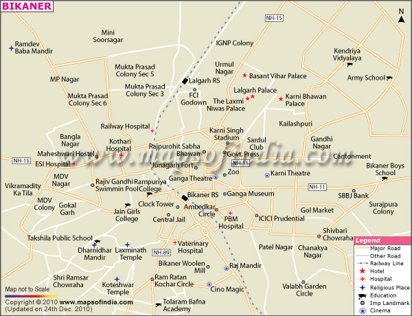
Bikaner city map :


Places Of Interest
Bhandashah Jain Temple
BikanerShare this:
Bhandashah Jain Temple Bhandashah Jain Temple is the oldest existing structure in Bikaner. The beautiful temple was erected near Laxminath temple in 1514 A.D. by two brothers Bhandeshwar and Sandheswar and named after them. It is believed that the temple was made with 40,000 kilograms of ghee instead of mortar, which locals insist seeps through … Continue reading Bhandashah Jain Temple →
Junagarh Fort
BikanerShare this:
Junagarh Fort Junagarh Fort Road, Bikaner, Rajasthan 334001 Phone: 0151 220 2297 Junagarh Fort is a fort in the city of Bikaner. The fort was originally called Chintamani and was renamed Junagarh or “Old Fort” in the early 20th century when the ruling family moved to Lalgarh Palace outside the fort limits. It is one of the few major forts in … Continue reading Junagarh Fort →
Karnimata Rat Temple
BikanerShare this:
Karnimata Rat Temple Karni Mata Temple Road Deshnok, NH 89, Bikaner – 334801 Phone :+91 98984 67264 Karni Mata Rat Temple is a Hindu temple dedicated to Karni Mata at Deshnoke, 30 km from Bikaner, in Rajasthan, India. It is also known as the Temple of Rats. The Karni Mata Rat Temple temple is famous … Continue reading Karnimata Rat Temple →
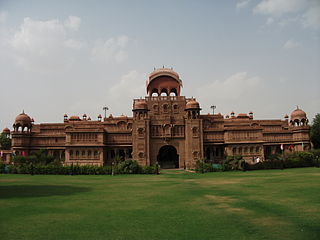
Lalgarh Palace & Sadul Museum
BikanerShare this:
Lalgarh Palace & Sadul Museum Lalgarh Palace, Bikaner – 334001 Phone : +91 151 2540201 Lalgarh Palace was built between 1902 and 1926 according to Rajput, Mughal and European architectural styles, being largely in the Indo- Saracenic style. The building was commissioned by the British -controlled regency for Maharaja Ganga Singh (1881–1942) while he was still in his minority as they … Continue reading Lalgarh Palace & Sadul Museum →
National Research Centre on Camel
BikanerShare this:
National Research Centre on Camel Post Box – 07, Jodhpur Bypass, Rajasthan 334001 Phone : 0151 223 0183 The Camel is an important animal component of the fragile desert eco-system. The camel has played a significant role in civil law and order, defense and battles from the ancient times till date. The camel helped the … Continue reading National Research Centre on Camel →
Prachina Museum
BikanerShare this:
Prachina Museum Bikaner Fort, Bikaner, Rajasthan 334001 Phone : 0151 2525609 PRACHINA Bikaner Cultural Center and Museum was established by Siddhi Kumari daughter of Late Maharaja Narendra Singhji of Bikaner in 2000, at the beginning of the new millennium with a vision to preserve Bikaner’s rich cultural diversity and to showcase monolithic identity of Bikaner … Continue reading Prachina Museum →
The Royal Cenotaphs
BikanerShare this:
The Royal Cenotaphs Sagar Rd, Ridmalsar, Rajasthan Considered as one of the finest examples of Rajasthani art and architecture, Devi Kund Sagar, situated 8 kilometers from Bikaner attracts large number of tourist every year. Devi Kund is a classic example of the Rajputana style of architecture. Devi Kund is a royal crematorium with elegant cenotaphs … Continue reading The Royal Cenotaphs →