Manali
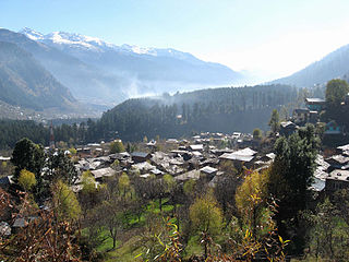
Manali is a hill station nestled in the mountains of the Himachal Pradesh near the northern end of the Kulu Valley, at an altitude of 2,050 m (6,726 ft) in the Beas River Valley . It is located in the Kulu district, about 270 km (168 mi) north of the state capital, Shimla. The small town, with a population of 8,096, is the beginning of an ancient trade route to Ladakh and from there over the Karakonam Pass on to Yarkand and Khotan in the Tarim Basin. It is a popular tourist destination and serves as the roadway to other northern hill stations
Manali is located at about 40 km (25 mi) north of Kullu town. The town ranges in elevation from 1,800 m (5,900 ft) to 2,000 m (6,600 ft) in the uppermost Old Manali section.
Climate
The climate in Manali is predominantly cold during winters, and moderately cool during summers. The temperatures range from 4 °C (39 °F) to 20 °C (68 °F) over the year. The average temperature during summer is between 04 °C (39 °F) and 15 °C (59 °F), and between −15 °C (5 °F) and 05 °C (41 °F) in the winter.
Tourism in Manali received a boost after the rise of militancy in Kashmir in the late 1980s. Manali, once quiet village was transformed into a bustling town with many hotels and restaurants.
Airport
The nearest airport Bhuntar Airport (IATA code KUU) is at Bhuntar town, situated on NH21 about 50 km (31 mi) south of Manali and 10 km (6.2 mi) south of Kullu town. The airport is also known as Kullu-Manali airport and has more than a kilometre long runway. Air India and some private airlines have regular flights to the airport. Chandigarh Airport is the nearest international airport.
Source : Wikipedia
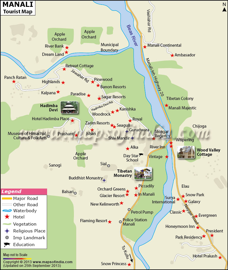
Tourist map of manali


Places Of Interest
Bhrigu Lake
ManaliShare this:
Bhrigu Lake Bhrigu Lake is a lake located at an elevation of around 4,300 metres (14,100 ft) in Kullu, Himachal Pradesh, India. It is located to the east of Rohtang Pass and is around 6 kilometres (3.7 mi) from Gulaba village. It can be reached by trekking either from the Vashishth temple, which is famous for its hot water springs, which is close to the town … Continue reading Bhrigu Lake →
Gulaba camp
ManaliShare this:
Gulaba camp Source : tripadvisor.com Gulaba, located 22 kms. from Manali is yet another excellent point to enjoy snow specially when Rohtang Pass is closed. . It is higher than Manali town and on the way to Rohtang Pass towards Spiti valley. This place is surrounded by snow lines and tall pine trees. Here there are beautiful … Continue reading Gulaba camp →
Hidimpa Temple
ManaliShare this:
Hidimpa Temple Circuit House Road, Old Manali, Manali, Himachal Pradesh 175131 Hidimbi Devi Temple, also known variously as the Hadimba Temple, is located in Manali, a hill station in the State of Himachal Pradesh.It is an ancient cave temple dedicated to Hidimbi Devi, sister of Hidimba, a figure in the Indian epic Mahabharata. The temple is surrounded by a cedar forest at … Continue reading Hidimpa Temple →
Manu Maharishi Temple
ManaliShare this:
Manu Maharishi Temple Old Manali, Manali, Himachal Pradesh 175131 The Manu Maharishi Temple is in the Old Manali region and is considered very sacred by the people of the town. This is the only temple in the country dedicated to the worship the Rishi Manu. As per Hindu mythology, Manu sage is considered to be the originator of … Continue reading Manu Maharishi Temple →
Pin Valley National Park
ManaliShare this:
Pin Valley National Park Spiti Valley, Himachal Pradesh 172117 The park is located 70kms.from Manali Pin Valley National Park is a National park of India located within the Lahaul and Spiti district, within the Cold Desert Biosphere Reserve, in the Himalayas region, in the state of Himachal Pradesh, in far Northern India. Spreading south of Dhankar Gompa near the Tibetan border, the park marks the border between the formerly separate … Continue reading Pin Valley National Park →
Rohtang Pass
ManaliShare this:
Rohtang Pass Rohtang Pass , (elevation 3,978 m (13,050 ft)), is a high mountain pass on the eastern Pir Panjal Range of the Himalayas around 51 km (32 mi) from Manali. The Rohtang pass provides a natural divide between the humid Kullu Valley with a primarily Hindu culture (in the south), and the arid high-altitude Lahaul and Spiti valleys with a Buddhist culture (in the north). The pass lies on the watershed between … Continue reading Rohtang Pass →
Solang Valley
ManaliShare this:
Solang Valley Solang Nala (Valley) drives its name from combination of words Solang (Nearby village) and Nullah (water stream). It is a side valley at the top of the Kullu Valley in Himachal Pradesh, 14 km northwest of the resort town Manali on the way to Rohtang Pass, and is known for its summer and winter sport conditions. The sports most commonly offered … Continue reading Solang Valley →
The Tibetan Monastery
ManaliShare this:
The Tibetan Monastery NH21, Siyal, Manali, Himachal Pradesh 175131 With a huge population of Tibetan people settled in the region of Kullu, several Tibetan Monasteries have been set up in Manali. The monasteries are rich in preserving the culture of the Tibetan people. The literature and the handicrafts of the people of Tibet are preserved … Continue reading The Tibetan Monastery →
Van Vihar
ManaliShare this:
Van Vihar NH21, Dhungri Village, Manali, Himachal Pradesh 175131 Van Vihar National Park is main attraction in Manali. Located near the Mall Road, this park is full of deodar trees that provide shade to the whole area. It has swings, slides and play areas for kids and benches where adults can sit back and enjoy … Continue reading Van Vihar →
Vashisht village
ManaliShare this:
Vashisht Village Vashisht village is located about 2 kms from Manali on the slopes above the Beas river. In the earlier vedic texts and In Ramayana Vashisht is mentioned as the home of one of the seven rishis or founding fathers of Vedic Civilization.The Vashisht temple with its hot sulphur springs is a popular destination. … Continue reading Vashisht village →